
Japan is an island nation in the northwest Pacific Ocean, stretching in a long arc from the Sea of Okhotsk in the north to the East China Sea in the south. Composed of four main islands — Honshu, Hokkaido, Kyushu, and Shikoku — along with thousands of smaller islands, Japan is defined by mountainous terrain, volcanic activity, and extensive coastlines.
The country lies along the Pacific Ring of Fire at the convergence of multiple tectonic plates, including the Pacific Plate, Philippine Sea Plate, and Eurasian Plate. This complex interaction has produced intense seismic activity, frequent earthquakes, and numerous volcanoes. Many of Japan’s mountains are volcanic in origin, and active peaks remain scattered throughout the archipelago.
Approximately 70% of Japan’s land area is mountainous, with narrow coastal plains supporting the majority of its population and agriculture. Rivers are typically short and fast-flowing due to steep gradients from mountain to sea.
The climate varies significantly by latitude and topography. Northern regions experience cold winters and heavy snowfall, while southern islands have subtropical conditions. The country is strongly influenced by seasonal monsoons and ocean currents, including the warm Kuroshio Current and the cold Oyashio Current.
Japan’s geography is dynamic — shaped by tectonic uplift, volcanic eruptions, typhoons, and coastal erosion. Mountains, forests, river valleys, and rugged shorelines define a landscape that is both dramatic and continuously evolving.
15. Tokyo

Tokyo lies on the eastern coast of Honshu along Tokyo Bay. Geography here is expansive coastal plain formed by river deposition and tectonic subsidence.
The city occupies much of the Kanto Plain, Japan’s largest lowland region. Over thousands of years, rivers such as the Tone and Arakawa carried sediment from surrounding mountains, gradually building fertile alluvial plains.

Tokyo Bay provides a sheltered maritime environment shaped by tidal processes and gradual land reclamation. Portions of the modern shoreline consist of reclaimed land built outward into the bay.

The region sits near the junction of several tectonic plates, making it one of the world’s most seismically active urban areas. Earthquakes are frequent due to subduction along the Pacific and Philippine Sea plates.

The climate is humid subtropical, with hot, wet summers influenced by the East Asian monsoon and mild winters. Typhoons occasionally impact the area in late summer and autumn.
Geologically, the Kanto Plain consists of layered sedimentary deposits overlying older bedrock. River flooding historically shaped settlement patterns, requiring extensive flood-control infrastructure.

Endurance here is tectonic and hydrological. Earthquake-resistant construction and river management are central to sustaining life on this low-lying plain.
Tokyo reflects eastern Japan’s basin-and-bay geography — river-built, sea-facing, and tectonically dynamic. Visitors encounter broad urban expanses framed by distant mountains, illustrating the balance between natural forces and coastal settlement.
14. Kyoto
Kyoto lies in a valley within central Honshu, surrounded by low mountains. Geography here is inland basin terrain shaped by tectonic movement and river erosion.
The Kyoto Basin formed along fault lines that created a depression later filled with sediment. Rivers such as the Kamo flow through the valley before joining larger river systems.
Mountains encircle the basin on three sides, limiting expansion and creating a distinct topographic enclosure. These uplands consist largely of sedimentary and metamorphic rock.
The climate is humid subtropical but more continental than coastal regions. Summers are hot and humid, while winters are cooler due to basin confinement.
Geologically, Kyoto sits on sediment layers over older bedrock shaped by tectonic uplift and erosion. Seasonal rainfall contributes to minor flooding along rivers.
Endurance here is fluvial and tectonic. Flood control and seismic resilience remain important in this enclosed valley setting.
Kyoto reflects central Japan’s basin geography — mountain-ringed, river-fed, and structurally defined by fault systems. Visitors encounter a landscape where enclosed valleys contrast sharply with Japan’s rugged coastal terrain.
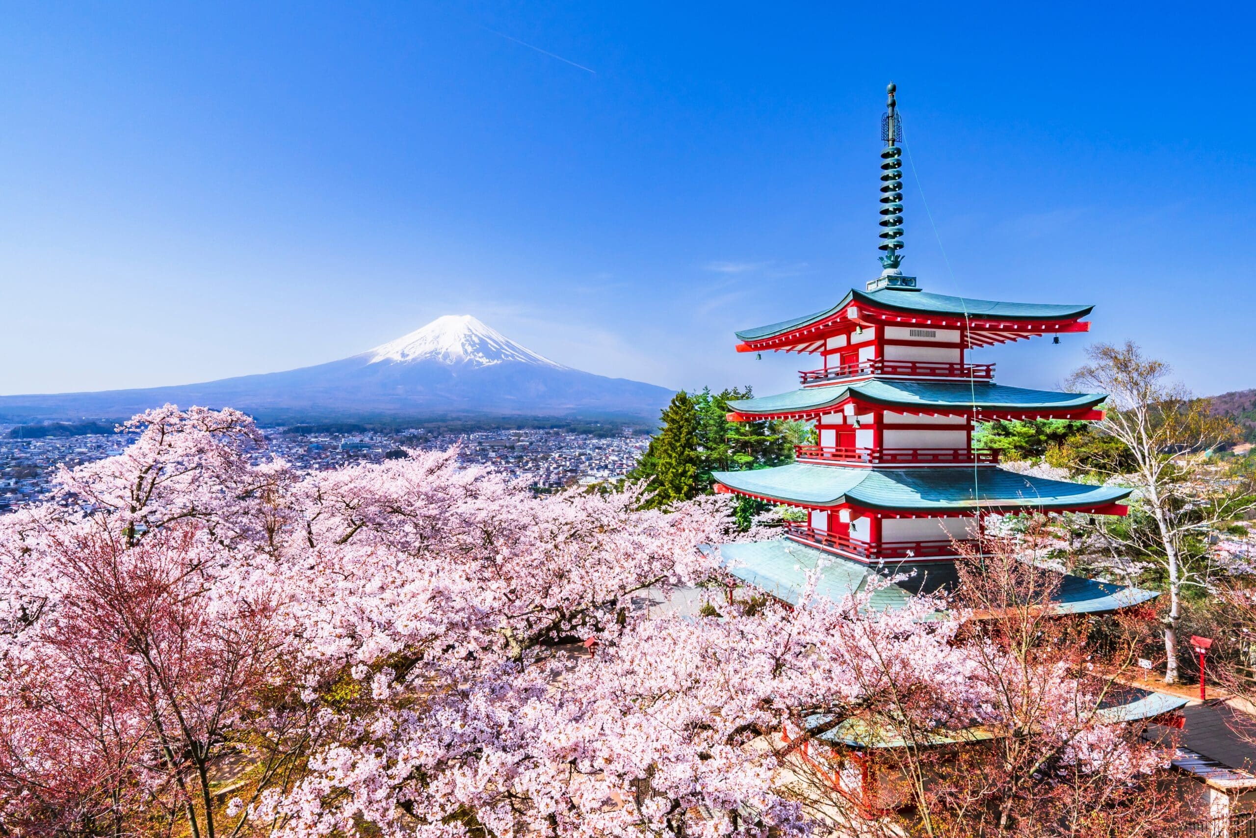
13. Mount Fuji
Mount Fuji rises to 3,776 meters and stands as Japan’s highest and most iconic mountain. Geography here is stratovolcanic peak formed by repeated eruptions along a complex plate boundary.
Mount Fuji sits near the convergence of the Pacific, Philippine Sea, and Eurasian plates. Subduction of oceanic plates beneath the Japanese archipelago generates magma that feeds volcanic activity.
The mountain’s symmetrical cone was built over thousands of years through alternating lava flows, ash deposits, and pyroclastic material. The most recent major eruption occurred in 1707–1708.
The surrounding terrain includes lava fields, volcanic forests, and crater lakes formed by previous eruptions. The Fuji Five Lakes lie along its northern base.
The climate varies with elevation. Lower slopes experience humid subtropical conditions, while the summit has alpine weather with snowfall in winter and early spring.
Geologically, Mount Fuji is considered active, though currently dormant. Volcanic monitoring systems track seismic and geothermal changes.
Endurance here is volcanic and climatic. Hazard preparedness is essential due to potential future eruptions.
Mount Fuji reflects Japan’s volcanic geography — plate-driven, symmetrical, and elevated above surrounding plains. Visitors encounter stark volcanic slopes that demonstrate the archipelago’s tectonic origin.
12. Osaka
Osaka lies on the southern edge of the Osaka Plain along Osaka Bay in central Honshu. Geography here is broad coastal lowland formed by river deposition and marine processes.
The plain developed from sediments carried by rivers such as the Yodo River, which drains Lake Biwa and surrounding mountains. Over time, alluvial deposits created fertile, flat terrain extending into Osaka Bay.
Much of the modern waterfront consists of reclaimed land built outward into the shallow bay. The coastline is shaped by tidal movement and gradual sediment accumulation.
The region sits near active fault systems associated with Japan’s complex plate boundaries. Earthquakes periodically affect the area due to regional tectonic stress.
The climate is humid subtropical, with hot, humid summers and relatively mild winters. Typhoons may bring heavy rainfall in late summer.
Geologically, Osaka rests on thick sedimentary layers overlying older bedrock. River flood control and coastal defenses are central to long-term stability.
Endurance here is coastal and tectonic. Seismic-resistant infrastructure and bay management are essential in this low-elevation urban plain.
Osaka reflects western Honshu’s delta-and-bay geography — river-built, sea-oriented, and tectonically influenced. Visitors encounter expansive flatlands framed by distant hills, demonstrating the role of sediment and shoreline evolution.
11. Hiroshima
Hiroshima lies along the Seto Inland Sea in southwestern Honshu. Geography here is river delta opening into a sheltered inland sea dotted with islands.
The city developed on a delta formed by multiple river channels descending from nearby mountains. Over centuries, sediment deposition created flat land extending toward the coast.
The Seto Inland Sea is partially enclosed by surrounding islands and peninsulas, resulting in relatively calm waters compared to the open Pacific.
The region’s terrain includes low mountains composed primarily of granite and other igneous rock. River systems carve valleys through these uplands before reaching the sea.
The climate is humid subtropical but moderated by the inland sea, resulting in relatively mild winters and warm summers.
Geologically, Hiroshima lies in an area shaped by ancient volcanic and tectonic processes. Though less seismically intense than eastern Japan, earthquakes still occur.
Endurance here is fluvial and coastal. Delta management and shoreline stability are ongoing considerations.
Hiroshima reflects southwestern Honshu’s island-delta geography — river-shaped, sea-buffered, and granite-framed. Visitors encounter layered waterways and calm maritime landscapes that contrast with Japan’s more exposed Pacific coast.
10. Sapporo
Sapporo lies in western Hokkaido on the Ishikari Plain. Geography here is northern alluvial plain bordered by volcanic and forested mountains.
The Ishikari River system deposited sediments across this broad lowland, forming fertile soils. Surrounding mountains include volcanic ranges shaped by subduction-related activity.
Hokkaido sits at the meeting point of the Pacific and Okhotsk tectonic systems. Volcanic peaks such as Mount Teine and nearby ranges reflect this geological history.
The climate is humid continental, distinct from much of Japan. Winters are long and snowy due to cold air masses from Siberia interacting with moisture from the Sea of Japan. Summers are mild and shorter.
Geologically, the region contains sedimentary deposits layered over older volcanic rock. Snowmelt contributes significantly to river flow each spring.
Endurance here is climatic. Heavy snowfall and seasonal freeze-thaw cycles influence infrastructure and land use.
Sapporo reflects northern Japan’s cold-climate plain geography — river-built, mountain-backed, and winter-dominated. Visitors encounter expansive snowy landscapes that illustrate Japan’s latitudinal climatic variation.
9. Nagasaki
Nagasaki lies on the western coast of Kyushu along a deeply indented natural harbor. Geography here is rugged coastal terrain shaped by submerged valleys and tectonic uplift.
The city occupies narrow inlets surrounded by steep hills composed largely of volcanic and sedimentary rock. The ria coastline formed as rising sea levels flooded river valleys, creating elongated bays and peninsulas.
Kyushu sits near active volcanic zones linked to subduction of the Philippine Sea Plate beneath the Eurasian Plate. The surrounding region contains geothermal activity and volcanic mountains.
The climate is humid subtropical, with warm summers and mild winters influenced by maritime conditions. Typhoons occasionally affect the area.
Geologically, Nagasaki rests on complex rock formations shaped by volcanic processes and crustal compression. The steep topography restricts flat land, concentrating development in valleys.
Endurance here is coastal and tectonic. Slope stability and harbor management are essential in this confined, mountainous shoreline.
Nagasaki reflects southwestern Japan’s ria-coast geography — valley-flooded, hill-bound, and sea-carved. Visitors encounter dramatic harbor views framed by steep slopes that demonstrate how tectonics and sea-level change shape coastal settlements.
8. Nara
Nara lies in the Nara Basin of central Honshu, surrounded by low mountains. Geography here is inland basin terrain formed by tectonic subsidence and sediment accumulation.
The basin developed along fault lines associated with crustal movement across central Japan. Rivers descending from surrounding hills deposited alluvial material across the valley floor.
Mountains enclosing the basin consist mainly of sedimentary and metamorphic rock uplifted through plate interaction. The enclosed topography creates a sheltered environment.
The climate is humid subtropical with relatively hot summers and cooler winters than coastal regions due to reduced maritime influence.
Geologically, Nara rests on layered sediments over older bedrock shaped by long-term tectonic processes. Seasonal rainfall supports river flow but can cause localized flooding.
Endurance here is fluvial and tectonic. Basin drainage management and seismic resilience remain ongoing concerns.
Nara reflects central Japan’s valley geography — mountain-ringed, sediment-filled, and structurally defined by faults. Visitors encounter enclosed plains that contrast with Japan’s steep coastal landscapes.
7. Hakone
Hakone lies within a volcanic caldera southwest of Tokyo. Geography here is mountainous volcanic terrain formed by repeated eruptions and crater collapse.
Hakone sits within the Fuji-Hakone-Izu volcanic zone, created by subduction of the Philippine Sea Plate beneath the Eurasian Plate. Explosive eruptions formed a caldera, later filled partly by Lake Ashi.
The surrounding mountains consist of volcanic rock including andesite and basalt. Steam vents, hot springs, and sulfur deposits indicate ongoing geothermal activity.
Lake Ashi occupies part of the caldera floor, formed when volcanic activity dammed river systems. The lake drains through short rivers descending toward the Pacific.
The climate is humid temperate, with cooler conditions at higher elevations. Rainfall is abundant due to orographic lifting of moist air.
Geologically, Hakone remains volcanically monitored. Though not currently erupting, geothermal activity is continuous.
Endurance here is volcanic and hydrological. Monitoring systems track seismic changes and geothermal fluctuations.
Hakone reflects eastern Honshu’s volcanic caldera geography — crater-formed, geothermal, and mountain-encircled. Visitors encounter steaming valleys and crater lakes that reveal the archipelago’s ongoing tectonic energy.
6. Sendai
Sendai lies along the Pacific coast of northeastern Honshu in the Tōhoku region. Geography here is coastal plain bordered by low mountains and river systems descending toward the ocean.
The city sits on the Sendai Plain, formed by sediment deposited from rivers flowing out of the Ou Mountain Range. Over time, alluvial material built flat land extending to the Pacific shoreline.
Offshore, the Pacific Plate subducts beneath the Okhotsk Plate along the Japan Trench. This tectonic boundary is responsible for major earthquakes and tsunami activity in the region.
The coastline consists of sandy beaches and low-lying agricultural land, making it vulnerable to storm surge and seismic sea waves.
The climate is humid temperate, with cold winters and warm summers. Snowfall occurs in winter, though less heavily than on the Sea of Japan side of Honshu.
Geologically, Sendai rests on thick sedimentary layers over older volcanic and metamorphic bedrock. Seismic activity remains a defining feature of the region.
Endurance here is tectonic and coastal. Tsunami preparedness and earthquake-resistant infrastructure are critical for long-term resilience.
Sendai reflects northeastern Japan’s subduction-zone geography — river-built, ocean-facing, and seismically active. Visitors encounter broad plains shaped by rivers yet defined by the powerful tectonic forces offshore.
5. Kobe
Kobe lies between the Rokko Mountains and Osaka Bay in western Honshu. Geography here is narrow coastal corridor compressed between steep uplands and the sea.
The Rokko Mountains rise sharply behind the city, composed largely of granite uplifted by tectonic movement. Rivers descending from these mountains carve short valleys before entering Osaka Bay.
The coastline includes both natural shoreline and reclaimed land extending into the bay. The region sits near active fault lines, including those associated with significant seismic events.
The climate is humid subtropical, moderated by Osaka Bay. Summers are warm and humid, while winters are relatively mild.
Geologically, the area is shaped by crustal compression and faulting linked to Japan’s broader plate interactions. The steep topography limits flat land availability.
Endurance here is tectonic and coastal. Earthquake-resistant construction and slope management are central to the city’s stability.
Kobe reflects western Honshu’s mountain-to-bay geography — granite-backed, sea-bound, and structurally constrained. Visitors encounter dramatic contrasts between steep hillsides and open harbor waters.
4. Yakushima
Yakushima is an island south of Kyushu in the East China Sea. Geography here is steep, mountainous island terrain shaped by granite uplift and heavy rainfall.
The island rises sharply from the sea, with peaks exceeding 1,900 meters. Much of its interior consists of ancient granite formed deep within Earth’s crust and later uplifted.
Yakushima receives some of the highest rainfall levels in Japan. Moist air from the surrounding ocean rises along steep slopes, producing persistent precipitation and dense forest growth.
Rivers are short and fast-flowing, cutting deep valleys through granite bedrock before reaching the coastline. The shoreline features rocky cliffs and small inlets shaped by wave erosion.
The climate ranges from subtropical at sea level to cool temperate conditions at higher elevations. Seasonal typhoons contribute to erosion and landscape change.
Geologically, Yakushima represents exposed plutonic rock uplifted through tectonic processes rather than volcanic activity.
Endurance here is climatic and erosional. Heavy rainfall and steep terrain continually reshape the island’s surface.
Yakushima reflects southern Japan’s high-rainfall island geography — granite-built, ocean-surrounded, and vertically dramatic. Visitors encounter mist-covered peaks that illustrate the interplay of uplift and persistent precipitation.
3. Kanazawa
Kanazawa lies along the Sea of Japan coast in central Honshu. Geography here is coastal plain backed by forested mountains and shaped by heavy winter snowfall.
The city developed on land formed by rivers descending from the Hakusan mountain range. Over time, alluvial sediments built flat terrain extending toward the sea.
Offshore, cold winter winds from Siberia cross the Sea of Japan, absorbing moisture before releasing heavy snowfall along the coast. This climatic pattern distinguishes the region from the Pacific side of Japan.
The surrounding mountains consist of volcanic and sedimentary rock uplifted by tectonic forces associated with Japan’s plate boundaries.
The climate is humid temperate, with significant snowfall in winter and warm, humid summers.
Geologically, the region reflects a combination of tectonic uplift and sediment deposition. Rivers continue to transport material from mountains to coast.
Endurance here is climatic and fluvial. Snow management and river control are central to long-term resilience.
Kanazawa reflects Sea of Japan coastal geography — snow-influenced, mountain-fed, and sediment-built. Visitors encounter a landscape shaped as much by winter storms as by tectonic forces.
2. Aso Caldera
Mount Aso is located in central Kyushu and contains one of the world’s largest volcanic calderas. Geography here is massive volcanic basin formed by catastrophic eruptions.
Thousands of years ago, explosive eruptions emptied underground magma chambers, causing the land above to collapse and form a wide caldera approximately 25 kilometers across. Within it rise several active volcanic cones.
The terrain consists largely of volcanic rock, ash deposits, and lava flows. Grasslands now cover portions of the caldera floor, while steep crater walls encircle the basin.
Kyushu lies near the subduction zone where the Philippine Sea Plate descends beneath the Eurasian Plate. This tectonic interaction drives volcanic activity.
The climate is humid subtropical, though higher elevations experience cooler temperatures. Rainfall contributes to erosion along caldera walls.
Geologically, Mount Aso remains active, with periodic eruptions and continuous monitoring.
Endurance here is volcanic. Hazard preparedness and monitoring are central to settlement and tourism in the area.
Aso Caldera reflects Kyushu’s explosive volcanic geography — collapse-formed, magma-driven, and tectonically active. Visitors encounter vast crater landscapes that demonstrate the immense scale of Japan’s volcanic processes.
1. Okinawa
Okinawa Island lies in the Ryukyu Archipelago between Kyushu and Taiwan. Geography here is subtropical coral island terrain shaped by marine processes and tectonic uplift.
Unlike mainland Japan’s steep mountains, Okinawa consists primarily of uplifted limestone derived from ancient coral reefs. Over time, tectonic forces raised reef formations above sea level.
The island features coastal cliffs, sandy beaches, and karst landscapes formed by dissolution of limestone. Coral reefs continue to grow in surrounding warm waters.
The climate is subtropical, with warm temperatures year-round and significant rainfall during monsoon and typhoon seasons.
Geologically, Okinawa sits along the Ryukyu Trench, where the Philippine Sea Plate subducts beneath the Eurasian Plate. Though less mountainous than Honshu, the region remains tectonically active.
Endurance here is marine and climatic. Typhoon resilience and coral conservation are essential for long-term environmental stability.
Okinawa reflects southern Japan’s reef-built island geography — uplifted, ocean-bound, and subtropical. Visitors encounter turquoise waters and limestone coasts that contrast sharply with Japan’s volcanic and mountainous mainland.