
Myanmar lies in mainland Southeast Asia, bordered by India, China, Laos, Thailand, and Bangladesh, with a long coastline along the Bay of Bengal and the Andaman Sea. Geography defines the country through mountain arcs, central river basins, and coastal deltas.
The Ayeyarwady River forms the backbone of Myanmar’s lowland system. Geography reinforces agricultural productivity through fertile floodplains shaped by monsoon cycles.
Mountain ranges frame the country on three sides. Geography binds settlement to river valleys carved between upland ridges.
The central dry zone contrasts with humid coastal regions. Geography emphasizes climatic variation influenced by elevation and monsoon direction.
The Ayeyarwady Delta opens toward the Andaman Sea. Geography requires adaptation to flooding, cyclones, and tidal influence.
Myanmar inspires through dramatic shifts between mountain highlands, central plains, and expansive coastline. The land teaches endurance through adaptation to seasonal rainfall extremes and river-based livelihoods, showing how resilience develops where uplands channel water toward fertile lowlands.
Endurance here is hydrological and climatic. Geography requires watershed preservation in mountainous regions and flood management in delta plains. Stability depends on balancing forest conservation with agricultural sustainability.
Myanmar reflects a Southeast Asian nation shaped by river systems, monsoon climate, and tectonic mountain arcs. Visitors encounter a landscape where resilience emerges from coexistence between Himalayan foothills, fertile basins, and coastal waters.
20. Yangon
Yangon lies in southern Myanmar near the Andaman Sea within the Ayeyarwady Delta region. Geography here is low-lying and riverine, defined by tidal creeks and deltaic plains.
The Yangon River flows southward into the Gulf of Martaban. Geography reinforces maritime orientation and river-based connectivity.
Flat terrain dominates the region. Geography binds urban expansion to slightly elevated ground above seasonal flood levels.
Monsoon rains bring heavy precipitation. Geography requires drainage systems and flood adaptation in soft alluvial soil.
Coastal proximity influences humidity and storm exposure. Geography emphasizes tidal patterns and sediment deposition.
Yangon inspires through alignment between river channels and tropical greenery. The land teaches endurance through adaptation to delta hydrology and seasonal rainfall, showing how resilience develops where urban life integrates with tidal waterways.
Endurance here is fluvial and coastal. Geography requires riverbank stabilization and protection from storm surge. Stability depends on managing sediment flow and preserving wetlands.
Yangon reflects Myanmar’s southern delta geography shaped by river discharge and monsoon intensity. Visitors encounter a landscape where resilience emerges from coexistence between fertile lowlands and maritime exposure.
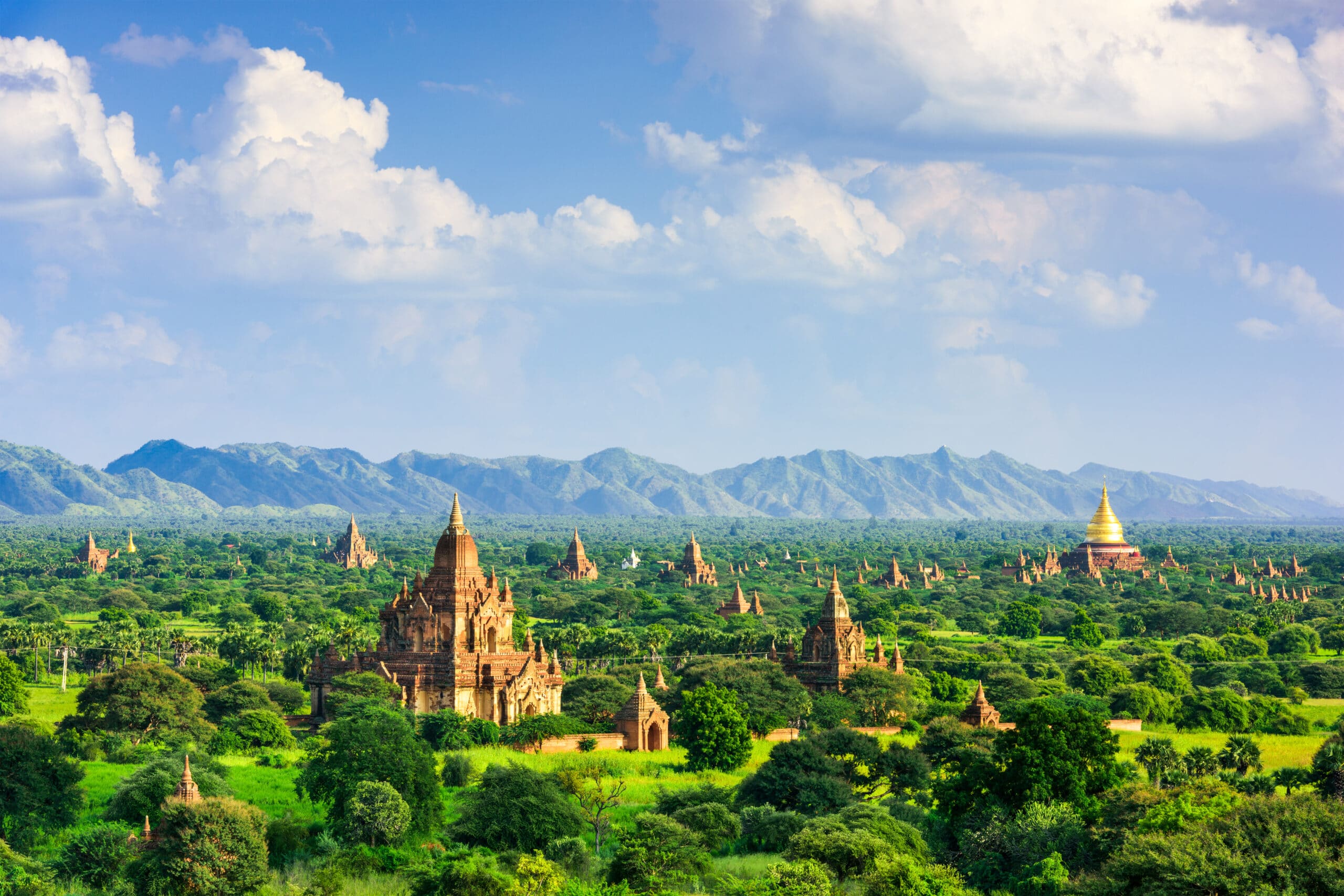
19. Bagan
Bagan lies in central Myanmar along the eastern bank of the Ayeyarwady River. Geography here is semi-arid plain within the country’s central dry zone.
The Ayeyarwady flows southward past the city. Geography reinforces settlement on slightly elevated terraces above seasonal flood levels.
The surrounding terrain is flat with sandy soils. Geography binds vegetation to drought-resistant species adapted to limited rainfall.
The dry zone climate contrasts sharply with Myanmar’s humid delta regions. Geography emphasizes monsoon variability and long dry seasons.
Low hills frame the western horizon. Geography requires adaptation to heat extremes and water scarcity.
Bagan inspires through its vast open plains beneath expansive skies. The land teaches endurance through adaptation to aridity and river proximity, showing how resilience develops where irrigation supports life in a semi-dry landscape.
Endurance here is climatic and hydrological. Geography requires sustainable water management and soil conservation. Stability depends on preserving river health while preventing desertification.
Bagan reflects Myanmar’s central basin geography shaped by tectonic subsidence and monsoon shadow effects. Visitors encounter a landscape where resilience emerges from coexistence between fertile riverbanks and arid plains.
18. Mandalay
Mandalay lies in upper central Myanmar along the Ayeyarwady River at the edge of the Shan Plateau. Geography here is transitional between river basin and upland highlands.
The Ayeyarwady widens through the region. Geography reinforces trade corridors and fertile floodplain agriculture.
To the east, the Shan Plateau rises abruptly. Geography binds settlement to the flatter western lowlands.
Seasonal monsoon rains moderate a generally dry climate. Geography emphasizes irrigation networks supporting cultivation.
Low isolated hills punctuate the plain. Geography requires adaptation to both river flooding and dry-season water limitations.
Mandalay inspires through its position between basin and plateau. The land teaches endurance through adaptation to geographic contrast, showing how resilience develops where river valleys meet upland terrain.
Endurance here is structural and hydrological. Geography requires careful watershed management and sustainable land use. Stability depends on balancing agricultural productivity with upland forest conservation.
Mandalay reflects Myanmar’s central geographic hinge between highland and lowland systems. Visitors encounter a landscape where resilience emerges from coexistence between expansive river plains and rising plateau formations.
17. Inle Lake
Inle Lake lies within the Shan Plateau in eastern Myanmar at an elevation of over 800 meters. Geography here is highland basin surrounded by rolling hills.
The lake occupies a natural depression. Geography reinforces freshwater storage within an upland watershed.
Surrounding hills channel rainfall into the basin. Geography binds agricultural practices to water-level fluctuations.
The plateau climate is cooler than central Myanmar. Geography emphasizes seasonal variation and reduced humidity.
Wetlands fringe the lake’s margins. Geography requires protection of aquatic ecosystems and sediment control.
Inle Lake inspires through its calm waters framed by distant hills. The land teaches endurance through adaptation to highland hydrology, showing how resilience develops where communities integrate livelihoods with freshwater ecosystems.
Endurance here is ecological and watershed-based. Geography requires preservation of upland forests and responsible lake management. Stability depends on maintaining water quality and preventing erosion.
Inle Lake reflects Myanmar’s eastern highland geography shaped by tectonic uplift and basin formation. Visitors encounter a landscape where resilience emerges from coexistence between mountain-fed waters and elevated plains.
16. Ngapali Beach
Ngapali Beach stretches along the Bay of Bengal in Rakhine State on Myanmar’s western coast. Geography here is coastal and tropical, defined by sandy shoreline backed by palm-lined plains and low hills.
The coastline curves gently along the open sea. Geography reinforces exposure to southwest monsoon winds and seasonal wave intensity.
Inland terrain rises gradually into modest elevations. Geography binds settlement to flat coastal strips and fishing corridors.
The Bay of Bengal influences tidal cycles and storm systems. Geography requires adaptation to cyclonic weather and coastal erosion.
Access routes follow narrow coastal roads. Geography emphasizes linear development parallel to the shoreline.
Ngapali Beach inspires through its open horizon and rhythmic surf. The land teaches endurance through adaptation to monsoon seas and maritime climate, showing how resilience develops where coastal communities align with seasonal tides.
Endurance here is coastal and climatic. Geography requires shoreline protection and sustainable marine resource management. Stability depends on preserving sandy beaches and coastal vegetation buffers.
Ngapali reflects Myanmar’s western maritime geography shaped by monsoon patterns and ocean exposure. Visitors encounter a landscape where resilience emerges from coexistence between palm-fringed beaches and the vast Bay of Bengal.
15. Hpa-An
Hpa-An lies in southeastern Myanmar along the Thanlwin River near the Thai border. Geography here is river valley framed by limestone karst formations.
The Thanlwin flows southward through the region. Geography reinforces settlement along fertile floodplains.
Dramatic limestone mountains rise sharply from flat terrain. Geography binds karst geology to cave systems and steep vertical relief.
Monsoon rains intensify river flow and sustain lush vegetation. Geography requires adaptation to flooding and slope erosion.
Transport corridors follow the river valley. Geography emphasizes natural passageways between rugged uplands.
Hpa-An inspires through towering limestone peaks reflected in calm river waters. The land teaches endurance through adaptation to karst landscapes and seasonal rainfall, showing how resilience develops where river systems carve pathways between ancient rock formations.
Endurance here is hydrological and geological. Geography requires conservation of limestone ecosystems and watershed stability. Stability depends on protecting forest cover on surrounding slopes.
Hpa-An reflects Myanmar’s southeastern geography shaped by tectonic uplift and fluvial processes. Visitors encounter a landscape where resilience emerges from coexistence between river plains and jagged karst ridges.
14. Pyin Oo Lwin
Pyin Oo Lwin sits on the Shan Plateau northeast of Mandalay at an elevation of approximately 1,000 meters. Geography here is upland and temperate relative to surrounding lowlands.
Rolling hills and forested slopes dominate the landscape. Geography reinforces cooler temperatures and higher rainfall compared to central dry zones.
Streams descend toward the Ayeyarwady basin. Geography binds watershed health to upland forest preservation.
Mist and cloud cover are common during monsoon months. Geography requires adaptation to variable mountain weather.
Road access climbs steadily from the plains below. Geography emphasizes transition from lowland heat to highland climate.
Pyin Oo Lwin inspires through its elevated vantage and cooler air. The land teaches endurance through adaptation to altitude and seasonal moisture, showing how resilience develops where upland plateaus moderate tropical extremes.
Endurance here is climatic and environmental. Geography requires slope management and protection of headwater streams. Stability depends on maintaining forest cover that regulates downstream water flow.
Pyin Oo Lwin reflects Myanmar’s plateau geography shaped by uplift and monsoon interaction. Visitors encounter a landscape where resilience emerges from coexistence between highland terrain and tropical climate systems.
13. Kyaiktiyo (Golden Rock)
Kyaiktiyo Pagoda stands atop Mount Kyaiktiyo in Mon State in southeastern Myanmar. Geography here is mountainous and elevated, defined by forested ridges rising above surrounding plains.
The pagoda sits near the summit on a granite boulder balanced on a cliff edge. Geography reinforces dramatic elevation and steep slopes that limit access.
Dense forest covers much of the mountain. Geography binds watershed systems to upland vegetation and monsoon rainfall.
Heavy seasonal rains influence slope stability. Geography requires adaptation to erosion risks and mountain weather variability.
Access roads wind upward from lowland towns. Geography emphasizes vertical ascent through narrowing ridgelines.
Kyaiktiyo inspires through its commanding position above vast lowland views. The land teaches endurance through adaptation to altitude and terrain steepness, showing how resilience develops where spiritual sites align with natural highpoints.
Endurance here is geological and climatic. Geography requires slope stabilization and forest preservation. Stability depends on protecting upland ecosystems that regulate water flow to lower regions.
Kyaiktiyo reflects Myanmar’s southeastern highland geography shaped by tectonic uplift and monsoon climate. Visitors encounter a landscape where resilience emerges from coexistence between granite summit and surrounding forested slopes.
12. Mrauk U
Mrauk U lies in northern Rakhine State near the Kaladan River. Geography here is river valley interspersed with low hills and wetlands.
The Kaladan River connects inland valleys to the Bay of Bengal. Geography reinforces settlement along navigable waterways.
Rolling hills rise amid flat plains. Geography binds agricultural land to fertile alluvial soils.
The region experiences heavy monsoon rainfall. Geography requires adaptation to flooding and soil erosion.
Limited overland routes increase reliance on river access. Geography emphasizes fluvial corridors over mountain crossings.
Mrauk U inspires through mist-covered hills and winding waterways. The land teaches endurance through adaptation to seasonal rainfall and riverine transport, showing how resilience develops where low hills and fertile plains converge.
Endurance here is hydrological and climatic. Geography requires riverbank protection and watershed management. Stability depends on maintaining soil fertility and wetland ecosystems.
Mrauk U reflects Myanmar’s western geography shaped by river systems flowing toward the Bay of Bengal. Visitors encounter a landscape where resilience emerges from coexistence between rolling hills and tidal river channels.
11. Kalaw
Kalaw sits on the western edge of the Shan Plateau at an elevation exceeding 1,300 meters. Geography here is highland and cool relative to Myanmar’s central basin.
Undulating hills and pine forests define the terrain. Geography reinforces moderate temperatures compared to surrounding lowlands.
Streams descend from plateau slopes into the Ayeyarwady watershed. Geography binds water systems to upland forest cover.
Frequent mist and rainfall occur during monsoon months. Geography requires adaptation to mountain weather and soil conservation.
Roads climb steadily from the plains toward the plateau. Geography emphasizes elevation gain and terrain transition.
Kalaw inspires through rolling uplands and forested ridges. The land teaches endurance through adaptation to altitude and seasonal variation, showing how resilience develops where plateau landscapes moderate tropical heat.
Endurance here is climatic and ecological. Geography requires slope protection and maintenance of forest cover. Stability depends on safeguarding headwater streams that sustain downstream communities.
Kalaw reflects Myanmar’s eastern highland geography shaped by plateau uplift and monsoon interaction. Visitors encounter a landscape where resilience emerges from coexistence between pine-covered hills and tropical lowlands below.
10. Bago
Bago lies northeast of Yangon along the Bago River in southern Myanmar. Geography here is lowland river plain shaped by monsoon-fed waterways and fertile soils.
The Bago River flows southward toward the Gulf of Martaban. Geography reinforces settlement along navigable channels and elevated floodplain terraces.
Flat terrain dominates the region. Geography binds agriculture to predictable seasonal flooding and sediment deposition.
Heavy monsoon rains influence river levels. Geography requires adaptation to periodic inundation and drainage management.
Transport corridors follow the river basin connecting inland towns to coastal ports. Geography emphasizes fluvial connectivity across the southern lowlands.
Bago inspires through its open plains framed by distant hills. The land teaches endurance through adaptation to delta proximity and seasonal water cycles, showing how resilience develops where communities align with river dynamics.
Endurance here is hydrological and agricultural. Geography requires riverbank stabilization and floodplain management. Stability depends on maintaining soil fertility while controlling flood risks.
Bago reflects Myanmar’s southern basin geography shaped by river systems flowing toward the Andaman Sea. Visitors encounter a landscape where resilience emerges from coexistence between fertile plains and monsoon-driven waterways.
9. Loikaw
Loikaw lies in eastern Myanmar within a valley surrounded by forested hills. Geography here is upland basin defined by rolling terrain and seasonal streams.
The Thanlwin River system influences the broader region. Geography reinforces watershed connections between upland hills and lowland valleys.
Elevated terrain moderates temperatures compared to central dry zones. Geography binds agriculture to terraced fields and river-fed irrigation.
Monsoon rainfall sustains dense vegetation. Geography requires adaptation to slope erosion and seasonal water flow.
Road access winds through mountain corridors. Geography emphasizes passage along natural valleys rather than across steep ridges.
Loikaw inspires through its quiet basin framed by green hills. The land teaches endurance through adaptation to upland isolation and rainfall variability, showing how resilience develops where plateau landscapes sustain valley communities.
Endurance here is climatic and ecological. Geography requires forest preservation and watershed stability. Stability depends on maintaining upland vegetation that regulates downstream water systems.
Loikaw reflects Myanmar’s eastern highland geography shaped by plateau uplift and monsoon interaction. Visitors encounter a landscape where resilience emerges from coexistence between rolling uplands and fertile valley floors.
8. Sittwe
Sittwe lies at the mouth of the Kaladan River on Myanmar’s western coast along the Bay of Bengal. Geography here is coastal estuary shaped by tidal influence and river discharge.
The Kaladan widens as it approaches the sea. Geography reinforces maritime trade routes and estuarine ecosystems.
Low-lying terrain extends inland. Geography binds settlement to slightly raised ground above tidal reach.
Cyclonic storms occasionally affect the region. Geography requires adaptation to storm surge and coastal erosion.
Fishing and river transport remain central. Geography emphasizes marine connectivity and delta navigation.
Sittwe inspires through its meeting point of river and ocean. The land teaches endurance through adaptation to tidal rhythms and monsoon storms, showing how resilience develops where freshwater systems merge with the Bay of Bengal.
Endurance here is coastal and hydrological. Geography requires mangrove preservation and shoreline stabilization. Stability depends on balancing estuarine ecology with urban settlement.
Sittwe reflects Myanmar’s western maritime geography shaped by river outflow and open-sea exposure. Visitors encounter a landscape where resilience emerges from coexistence between tidal waterways and coastal plains.
7. Hsipaw
Hsipaw lies in northern Shan State within a valley carved by the Dokhtawady River. Geography here is highland basin framed by forested ridges and rolling hills.
The Dokhtawady flows southward through the valley. Geography reinforces agricultural activity along fertile riverbanks.
Steep hills surround the settlement. Geography binds transport routes to narrow passes and river corridors.
The plateau climate brings cooler temperatures compared to central Myanmar. Geography requires adaptation to seasonal rainfall and upland soil conditions.
Terraced cultivation appears on valley slopes. Geography emphasizes land use shaped by elevation and watershed dynamics.
Hsipaw inspires through its layered hills and quiet river bends. The land teaches endurance through adaptation to upland isolation and climatic variation, showing how resilience develops where plateau valleys sustain rural communities.
Endurance here is climatic and hydrological. Geography requires slope conservation and maintenance of forest cover to protect river systems. Stability depends on safeguarding upland watersheds feeding the Dokhtawady.
Hsipaw reflects Myanmar’s northern highland geography shaped by tectonic uplift and plateau formation. Visitors encounter a landscape where resilience emerges from coexistence between terraced hillsides and flowing river channels.
6. Dawei
Dawei lies along Myanmar’s southeastern coast facing the Andaman Sea. Geography here is coastal plain bordered by mountain ridges of the Tenasserim Range.
The Dawei River flows westward into the sea. Geography reinforces settlement along estuarine lowlands.
Sandy beaches stretch along portions of the coastline. Geography binds marine livelihoods to seasonal tidal patterns.
Monsoon systems bring heavy rainfall during the wet season. Geography requires adaptation to flooding and coastal weather shifts.
Mountain ranges rise inland toward the Thai border. Geography emphasizes natural barriers that shape inland connectivity.
Dawei inspires through its balance between forested highlands and open sea horizons. The land teaches endurance through adaptation to maritime exposure and monsoon rainfall, showing how resilience develops where river valleys open into coastal plains.
Endurance here is coastal and hydrological. Geography requires mangrove preservation and watershed management from upland slopes. Stability depends on protecting estuarine ecosystems and regulating soil erosion.
Dawei reflects Myanmar’s southern maritime geography shaped by mountain ridges and Andaman currents. Visitors encounter a landscape where resilience emerges from coexistence between coastal plains and rising interior ranges.
5. Putao
Putao lies in far northern Myanmar near the foothills of the eastern Himalayas. Geography here is alpine and riverine, surrounded by some of Southeast Asia’s highest mountain peaks.
Snow-fed rivers descend from glaciated summits. Geography reinforces freshwater systems flowing into the Ayeyarwady basin.
Steep valleys and dense forests dominate the terrain. Geography binds isolation to rugged topography and limited road access.
The climate varies sharply with elevation. Geography requires adaptation to cooler temperatures and seasonal rainfall influenced by mountain weather systems.
Mountain passes restrict connectivity. Geography emphasizes natural remoteness shaped by high-altitude terrain.
Putao inspires through dramatic peaks rising above deep green valleys. The land teaches endurance through adaptation to altitude and environmental extremes, showing how resilience develops where Himalayan foothills merge with tropical forests.
Endurance here is ecological and climatic. Geography requires protection of alpine ecosystems and careful watershed conservation. Stability depends on preserving headwater rivers that supply downstream regions.
Putao reflects Myanmar’s northern frontier geography shaped by Himalayan uplift and river formation. Visitors encounter a landscape where resilience emerges from coexistence between towering mountains and remote forest valleys.
4. Mawlamyine
Mawlamyine lies in southeastern Myanmar at the confluence of the Thanlwin River and the Gulf of Martaban. Geography here is coastal estuary shaped by wide river channels and tidal influence.
The Thanlwin widens dramatically before reaching the sea. Geography reinforces settlement on elevated ridges above tidal plains.
Low hills rise behind the city. Geography binds upland forest cover to river watershed stability.
Monsoon rains swell the river during the wet season. Geography requires adaptation to seasonal flooding and shoreline erosion.
Bridges and ferries connect communities across broad waterways. Geography emphasizes river-based transport and estuarine navigation.
Mawlamyine inspires through expansive river views merging into coastal horizons. The land teaches endurance through adaptation to tidal rhythms and monsoon rains, showing how resilience develops where major river systems meet open sea.
Endurance here is hydrological and coastal. Geography requires mangrove preservation and riverbank stabilization. Stability depends on protecting estuarine ecosystems that buffer storm impact.
Mawlamyine reflects Myanmar’s southeastern geography shaped by the powerful Thanlwin watershed and maritime exposure. Visitors encounter a landscape where resilience emerges from coexistence between river delta and coastal waters.
3. Pyay
Pyay lies along the eastern bank of the Ayeyarwady River in central Myanmar. Geography here is river plain transitioning toward low mountain ridges to the west.
The Ayeyarwady flows steadily southward through the region. Geography reinforces agricultural productivity along fertile alluvial soils.
Low hills form part of the Rakhine Yoma range nearby. Geography binds the central basin to western upland systems.
The area experiences a dry-season climate typical of Myanmar’s central zone. Geography requires adaptation to limited rainfall outside monsoon months.
River transport remains important. Geography emphasizes the Ayeyarwady as a central corridor linking upper and lower Myanmar.
Pyay inspires through its open river vistas and proximity to rising western hills. The land teaches endurance through adaptation to seasonal water cycles and climatic contrast, showing how resilience develops where river plains meet mountain foothills.
Endurance here is agricultural and hydrological. Geography requires irrigation systems and slope conservation in adjacent uplands. Stability depends on balancing river management with forest preservation in the Rakhine Yoma.
Pyay reflects Myanmar’s central geographic corridor shaped by the Ayeyarwady basin and surrounding highlands. Visitors encounter a landscape where resilience emerges from coexistence between broad river plains and protective mountain arcs.
2. Tachileik
Tachileik lies in eastern Shan State along the border with Thailand. Geography here is mountainous frontier terrain defined by ridges and narrow valleys.
The Mae Sai River marks part of the international boundary. Geography reinforces settlement along valley floors where water and arable land are available.
Steep forested hills surround the town. Geography binds transport routes to mountain passes and river crossings.
The climate is tropical but moderated slightly by elevation. Geography requires adaptation to heavy monsoon rainfall and hillside runoff.
Cross-border roads pass through natural corridors in the hills. Geography emphasizes connectivity shaped by terrain constraints.
Tachileik inspires through its position at the meeting of upland ranges and river valleys. The land teaches endurance through adaptation to frontier geography and monsoon weather, showing how resilience develops where mountainous landscapes define boundaries.
Endurance here is climatic and topographical. Geography requires erosion control and protection of upland forests. Stability depends on safeguarding watershed systems feeding regional rivers.
Tachileik reflects Myanmar’s eastern border geography shaped by plateau ridges and river valleys. Visitors encounter a landscape where resilience emerges from coexistence between mountain terrain and valley settlement.
1. Hakha
Hakha lies in western Myanmar within the Chin Hills near the border with India. Geography here is mountainous and elevated, characterized by steep ridgelines and narrow valleys.
The city sits along a high ridge at approximately 1,800 meters above sea level. Geography reinforces dramatic elevation changes and limited flat land for expansion.
Deep valleys descend toward tributaries feeding the Kaladan River system. Geography binds watershed integrity to forest cover on surrounding slopes.
The climate is cooler than Myanmar’s central plains due to altitude. Geography requires adaptation to heavy monsoon rains and landslide risks on steep terrain.
Road access winds through mountain passes linking Hakha to lower regions. Geography emphasizes natural isolation shaped by rugged relief.
Hakha inspires through sweeping mountain panoramas and layered hill silhouettes fading into mist. The land teaches endurance through adaptation to altitude, slope instability, and climatic variation, showing how resilience develops where communities anchor themselves along narrow ridges.
Endurance here is topographical and climatic. Geography requires slope stabilization, forest conservation, and careful road engineering. Stability depends on protecting upland vegetation that regulates rainfall runoff and prevents erosion.
Hakha reflects Myanmar’s western highland geography shaped by tectonic uplift and monsoon interaction. Visitors encounter a landscape where resilience emerges from coexistence between steep mountain ridges and remote upland valleys.