
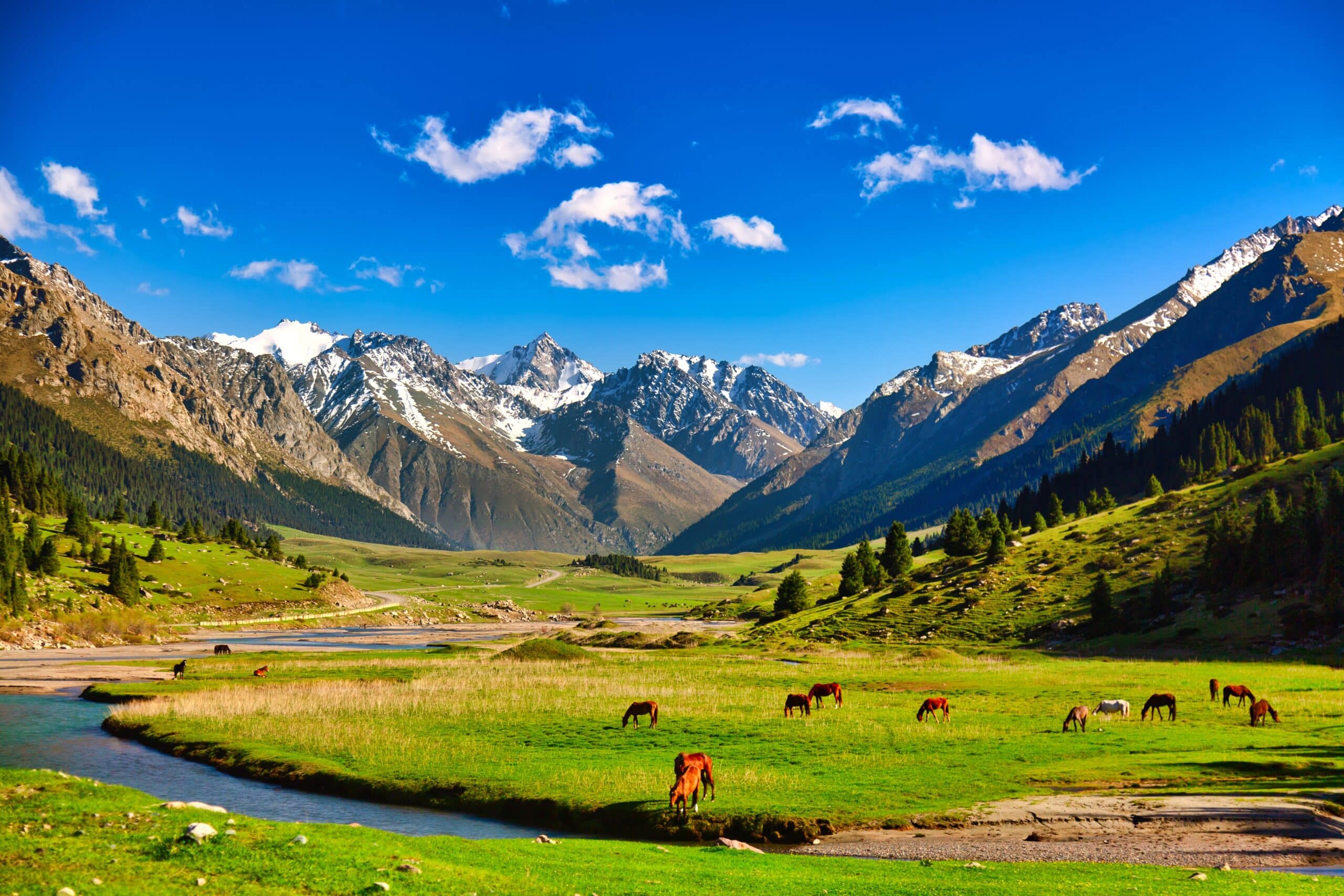
Kyrgyzstan is a country defined less by borders than by elevation. More than ninety percent of its territory rises into mountains, and geography here does not decorate life — it governs it. The Tian Shan range carves the nation into valleys, plateaus, and high basins where rivers begin and routes narrow. Flatness is rare; horizon is earned.
Altitude shapes climate, movement, settlement, and tradition. Winters gather heavily in enclosed valleys. Summers open alpine pastures to grazing. Rivers descend from glaciers that hold the memory of winter even in July. Geography determines timing. It determines where roads can pass, where crops can grow, where herds can rest.
Yet Kyrgyzstan is not only vertical. Between peaks lie wide grasslands, mineral lakes, and sheltered valleys that soften severity. These spaces do not contradict the mountains; they depend on them. Snowmelt sustains irrigation. Passes enable trade. Basins cradle communities that would otherwise scatter across impossible terrain.
Movement in Kyrgyzstan follows natural logic. Roads bend around ridges. Trails climb toward summer pastures. Settlements cluster where water collects. Geography teaches orientation and patience. Distance is measured less in kilometers than in ascent and descent.
What defines Kyrgyzstan is not isolation, but resilience shaped by terrain. Life here adapts rather than resists. Architecture lowers against wind. Traditions migrate with season. Strength emerges through adjustment to gradient, altitude, and exposure.
To travel through Kyrgyzstan is to understand geography as authority. The land instructs quietly but firmly. It offers beauty without excess, challenge without hostility. And within its valleys and along its ridgelines, endurance becomes not an act of struggle, but a habit shaped by mountains that never withdraw.
18. Issyk-Kul Lake
Issyk-Kul lies in eastern Kyrgyzstan, held within a vast mountain basin between the Terskey and Kungey Ala-Too ranges. Geography here is protective and expansive at once. Snow-fed peaks rise sharply from a shoreline that curves for hundreds of kilometers, enclosing one of the world’s largest alpine lakes.
Despite its elevation, Issyk-Kul rarely freezes. Mineral content and depth stabilize its waters, reinforcing the lake’s identity as a constant presence within a changing climate. Geography gathers rivers from surrounding slopes and holds them in long blue suspension.
Movement along Issyk-Kul follows the arc of the basin. Roads trace the shoreline, shifting between open steppe and cultivated fields. Geography shapes rhythm through contrast—mountain wall and water plane existing in steady dialogue.
The lake inspires through balance. The land teaches endurance through containment, showing how resilience can emerge where geography shelters life without isolating it. Communities align along its margins, sustained by water, soil, and moderated air.
Endurance here is climatic and spatial. Geography softens extremes, creating habitable continuity within high altitude. The mountains protect, yet they do not confine entirely.
Issyk-Kul reflects a Kyrgyzstan where geography gathers strength through enclosure and openness combined. Visitors encounter a landscape that reinforces resilience as equilibrium—between height and depth, cold and warmth, isolation and connection.
17. Ala Archa National Park
Ala Archa rises south of Bishkek, where the Tian Shan thrust upward in steep granite ridges and glaciated valleys. Geography here is immediate and vertical. Snowfields and exposed rock dominate skyline and perception.
Rivers descend quickly from high glaciers, cutting narrow gorges through forested lower slopes. Geography shapes intensity; altitude increases sharply within short distances, transforming vegetation and temperature within hours of ascent.
Movement through Ala Archa is deliberate and upward. Trails follow river valleys before climbing toward alpine basins and peaks. Geography dictates pace through gradient and thinning air, reinforcing awareness of effort.
The park inspires through clarity. The land teaches endurance through elevation, showing how resilience grows when ascent demands patience and adaptation. Each step upward reshapes horizon and perspective.
Endurance here is physical and environmental. Geography offers little moderation at higher altitudes, exposing visitors to wind, snow, and sudden change. Strength develops through adjustment rather than resistance.
Ala Archa reflects a Kyrgyzstan where geography defines identity through height. Visitors encounter a landscape that reinforces resilience as upward striving—measured not by speed, but by persistence within steep and unyielding terrain.
16. Song-Kul Lake
Song-Kul rests high on a plateau in central Kyrgyzstan, surrounded by rolling grasslands and distant mountain walls. Geography here is elevated but open. The lake sits above tree line, exposed to wind and vast sky.
Water gathers quietly within this high basin, fed by snowmelt and seasonal streams. Geography supports pastoral life rather than dense settlement. Grasslands extend outward in soft curves, shaped by grazing and climate.
Movement across Song-Kul is horizontal rather than vertical. Riders and travelers follow gentle slopes and wide valleys, guided by natural contours instead of fixed roads. Geography encourages seasonal migration, reinforcing mobility.
Song-Kul inspires through simplicity. The land teaches endurance through rhythm, showing how resilience can flourish where life aligns with seasonal return. Summers bring habitation; winters restore solitude.
Endurance here is nomadic and cyclical. Geography requires flexibility—structures are temporary, yet patterns are enduring. Adaptation becomes tradition rather than disruption.
Song-Kul reflects a Kyrgyzstan where geography shapes resilience through openness. Visitors encounter a landscape that emphasizes continuity through movement, reminding that endurance may depend on returning in season rather than remaining permanently.
15. Tash Rabat Caravanserai
Tash Rabat stands in a high valley of the At-Bashy range, a stone structure embedded directly into mountainous terrain. Geography here is remote and deliberate. The caravanserai occupies a sheltered basin once aligned with trade routes crossing formidable passes.
The surrounding land is austere—rolling uplands, cold streams, and distant ridges marking the edges of movement. Geography dictates isolation; snow and wind restrict access for much of the year. Yet the valley itself softens exposure, creating a pocket of relative calm within high elevation.
Movement toward Tash Rabat follows narrow roads that mirror ancient pathways. Geography shapes approach gradually, reinforcing awareness of ascent and distance from lowland settlements. Arrival feels earned.
The site inspires through endurance across centuries. The land teaches resilience through positioning, showing how geography can provide protection even within severe surroundings. Stone walls merge with hillside, reducing vulnerability to wind and cold.
Endurance here is architectural and geographic. Geography dictated the caravanserai’s placement; its survival affirms the wisdom of that alignment. Shelter emerges not from domination of terrain but from cooperation with it.
Tash Rabat reflects a Kyrgyzstan where geography governs both commerce and survival. Visitors encounter a landscape that reinforces resilience as foresight—strength achieved through understanding terrain before confronting it.
14. Jeti-Ögüz Gorge
Jeti-Ögüz Gorge cuts into red sandstone cliffs south of Issyk-Kul, forming one of Kyrgyzstan’s most visually distinctive valleys. Geography here is expressive. Layers of mineral-rich rock rise in sculpted formations shaped by erosion and time.
The gorge narrows between forested slopes, guiding a river through its center. Geography binds water, vegetation, and stone into a contained corridor. The red cliffs absorb and reflect sunlight differently throughout the day, shifting tone and intensity.
Movement through Jeti-Ögüz follows the river upward. Paths ascend gradually, allowing terrain to unfold through curvature rather than abrupt change. Geography shapes pace through enclosure rather than steepness.
The gorge inspires through contrast. The land teaches endurance through color and formation, showing how resilience can manifest visibly within fragile rock shaped by persistent erosion. Time here is layered and exposed.
Endurance is geological and seasonal. Geography allows snow to settle in winter and wildflowers to bloom in summer, reinforcing cyclical renewal within fixed stone boundaries.
Jeti-Ögüz reflects a Kyrgyzstan where geography reveals endurance through transformation. Visitors encounter a landscape that emphasizes resilience as adaptation to light, water, and gradual change rather than resistance to them.
13. Sary-Chelek Lake
Sary-Chelek lies in western Kyrgyzstan within a forested biosphere reserve enclosed by steep ridges. Geography here is protective and humid compared to the country’s drier high plateaus. The lake occupies a deep basin formed by ancient landslides and tectonic activity.
Dense woodland surrounds its shoreline, reinforcing enclosure. Geography moderates temperature and gathers biodiversity rarely found elsewhere in the country. Multiple smaller lakes dot the surrounding slopes, shaped by the same geological forces.
Movement through Sary-Chelek follows winding mountain roads and forest paths. Geography restricts speed, encouraging deliberate navigation through narrow valleys and shaded corridors.
The lake inspires through quiet abundance. The land teaches endurance through concentration, showing how resilience can develop where geography gathers water, soil, and shelter within confined terrain. Life thrives not because conditions are easy, but because they are balanced.
Endurance here is ecological. Geography sustains layered systems—forest canopy, undergrowth, freshwater, and wildlife interdependent within a limited basin.
Sary-Chelek reflects a Kyrgyzstan where geography nurtures resilience through protection. Visitors encounter a landscape that reinforces endurance as harmony—formed not by vast openness, but by carefully enclosed and sustained life.
12. Kel-Suu Lake
Kel-Suu lies in southeastern Kyrgyzstan near the Chinese border, concealed within a narrow mountain gorge at high elevation. Geography here is secretive and severe. Steep limestone walls enclose the lake so tightly that access is possible only through remote valleys and rugged tracks.
The lake’s water gathers from underground springs and snowmelt, filling a basin shaped by tectonic forces. Geography dictates unpredictability; water levels fluctuate seasonally, sometimes draining partially into subterranean channels. The land appears stable, yet change remains constant beneath the surface.
Movement toward Kel-Suu is gradual and demanding. Trails cross open plateau before narrowing into confined canyon corridors. Geography reduces scale step by step, shifting from expansive grassland to enclosed rock walls.
Kel-Suu inspires through concealment. The land teaches endurance through patience, showing how resilience can be found where geography withholds easy access. The lake does not reveal itself quickly; arrival requires adaptation to altitude, remoteness, and wind.
Endurance here is elemental. Geography exposes travelers to open sky before guiding them into stone embrace. Survival and experience depend on preparation rather than impulse.
Kel-Suu reflects a Kyrgyzstan where geography shapes resilience through remoteness. Visitors encounter a landscape that reinforces endurance as quiet persistence within terrain that reveals its depth only to those willing to reach it.
11. Arslanbob Walnut Forest
Arslanbob spreads across the Fergana Range in western Kyrgyzstan, where the world’s largest natural walnut forest grows along mountain slopes. Geography here is generous compared to the surrounding highlands. Moisture gathers along ridges, sustaining dense woodland in a country largely defined by alpine pasture.
Streams descend through forested valleys, nourishing orchards and villages below. Geography supports agriculture and gathering, reinforcing a relationship between land and livelihood shaped by season and elevation.
Movement through Arslanbob follows shaded paths and terraced slopes. Geography moderates climate beneath tree canopy, softening summer heat and protecting soil from erosion. The terrain rises and falls gently rather than abruptly.
The forest inspires through continuity. The land teaches endurance through renewal, showing how resilience develops where geography permits regeneration. Walnut trees mature slowly yet live long, embodying patience within growth.
Endurance here is ecological and communal. Geography sustains harvest cycles that link families to forest across generations. The land provides not abundance without effort, but abundance aligned with stewardship.
Arslanbob reflects a Kyrgyzstan where geography nurtures resilience through fertility and care. Visitors encounter a landscape that reinforces endurance as continuity between people and terrain, shaped by slopes that protect life rather than challenge it.
10. Alay Valley
The Alay Valley stretches across southern Kyrgyzstan as a broad corridor between the Tian Shan and Pamir ranges. Geography here is expansive yet elevated. Snow-capped peaks frame an open grassland plain that rises more than three thousand meters above sea level.
Rivers thread across the valley floor, fed by glaciers that dominate the horizon. Geography balances enclosure with openness. The mountains confine the valley laterally, yet the plain itself allows unobstructed movement across its width.
Travel through the Alay Valley emphasizes horizontal distance rather than ascent. Roads follow the natural corridor, linking passes that connect Central Asia’s high mountain systems. Geography defines the valley as passage rather than isolation.
The Alay inspires through scale. The land teaches endurance through coexistence with immensity, showing how resilience grows where exposure and shelter exist simultaneously. Wind sweeps across open pasture, yet peaks provide orientation and protection.
Endurance here is pastoral and climatic. Geography supports seasonal grazing within a high-altitude environment that demands adaptation to cold and wind. Strength emerges through rhythm rather than resistance.
The Alay Valley reflects a Kyrgyzstan where geography shapes resilience through breadth within elevation. Visitors encounter a landscape that reinforces endurance as balance—between openness and boundary, exposure and refuge—formed by mountains that define space without suffocating it.
9. Lenin Peak Base Area
Lenin Peak rises along the southern frontier of Kyrgyzstan, forming one of the most prominent summits in the Pamir-Alay system. Geography here is monumental and exposed. The mountain dominates the skyline above broad alpine meadows that serve as seasonal base camps.
Glaciers descend from its upper slopes, feeding streams that cross the Achik-Tash valley below. Geography binds ice and grassland into one dramatic system, where summer pasture exists beneath permanent snow. Elevation shapes every condition—temperature, vegetation, and movement.
Approach to the base area follows gradual ascent through open terrain. The valley widens before narrowing toward the mountain’s mass. Geography creates anticipation through visibility; the summit remains constantly in view, reinforcing scale and distance.
The region inspires through magnitude. The land teaches endurance through aspiration, showing how resilience develops in the presence of overwhelming height. Even without summiting, visitors confront the discipline required by altitude and exposure.
Endurance here is glacial and human. Geography sustains ice fields that endure across centuries, while climbers adapt to thin air and shifting weather. Strength depends on preparation and humility before terrain.
The Lenin Peak Base Area reflects a Kyrgyzstan where geography defines ambition through elevation. Visitors encounter a landscape that reinforces resilience as measured persistence—progress shaped by respect for altitude rather than conquest of it.
8. Skazka Canyon
Skazka Canyon lies along the southern shore of Issyk-Kul, where wind and water have sculpted sandstone into layered formations. Geography here is imaginative yet grounded in erosion. Red and ochre ridges rise in shapes that resemble fortresses and flowing waves.
The canyon is dry for most of the year, carved by seasonal runoff that cuts narrow channels into soft rock. Geography reveals process openly; every ridge records gradual transformation shaped by climate and time.
Movement through Skazka is exploratory rather than linear. Paths wind between formations, rising gently toward viewpoints overlooking the lake. Geography shapes perception through curvature and color rather than altitude.
Skazka inspires through creativity. The land teaches endurance through gradual shaping, showing how resilience can emerge from persistent natural forces acting without haste. What appears fragile persists through balance between erosion and structure.
Endurance here is visual and geological. Geography transforms light across surfaces throughout the day, reinforcing awareness of change within continuity. The canyon shifts in tone yet remains fundamentally intact.
Skazka reflects a Kyrgyzstan where geography expresses resilience through form. Visitors encounter a landscape that reframes endurance as adaptation to elements, shaped slowly by wind and water across generations.
7. Chong-Kemin Valley
Chong-Kemin Valley stretches between parallel mountain ridges east of Bishkek, forming a long, fertile corridor sustained by the Chong-Kemin River. Geography here is protective and agricultural. Forested slopes descend into cultivated fields that line the valley floor.
Snowmelt from surrounding peaks feeds the river system, reinforcing the valley’s role as a natural conduit for water and settlement. Geography balances elevation with habitability, allowing orchards and pasture to thrive within mountain enclosure.
Movement through Chong-Kemin follows the river’s course. Roads remain close to water, guided by terrain that narrows and widens in gentle sequence. Geography determines settlement patterns, clustering life along fertile margins.
The valley inspires through continuity. The land teaches endurance through integration, showing how resilience develops where geography aligns water, soil, and shelter within manageable scale. Unlike higher alpine regions, this valley supports sustained habitation rather than seasonal return.
Endurance here is agricultural and ecological. Geography enables renewal through seasonal cycles—spring thaw, summer growth, autumn harvest. The mountains protect without isolating entirely.
Chong-Kemin Valley reflects a Kyrgyzstan where geography sustains resilience through balance. Visitors encounter a landscape that reinforces endurance as coexistence—between cultivation and wilderness, movement and rootedness—shaped by a river that binds mountain and meadow into one continuous system.
6. Saimaluu-Tash Petroglyphs
Saimaluu-Tash lies high in the Fergana Range of western Kyrgyzstan, where alpine meadows conceal one of Central Asia’s most extensive collections of petroglyphs. Geography here is elevated and seasonal. Snow covers the plateau for much of the year, revealing stone only during brief summer months.
Thousands of engraved boulders scatter across rolling grassland shaped by glacial movement. Geography preserves and exposes simultaneously. The altitude restricts access, while summer pasture opens the plateau to grazing and exploration.
Movement toward Saimaluu-Tash requires ascent along steep tracks and remote valleys. Geography limits approach to those prepared for isolation and changing weather. The journey itself reinforces awareness of remoteness.
The site inspires through continuity across time. The land teaches endurance through record, showing how resilience can be etched directly into terrain. Carved images of animals, rituals, and daily life persist because geography shielded them through altitude and seasonal concealment.
Endurance here is cultural and environmental. Geography shaped not only preservation but also meaning; the plateau once served as summer pasture, linking spiritual expression to seasonal migration.
Saimaluu-Tash reflects a Kyrgyzstan where geography safeguards memory. Visitors encounter a landscape that reinforces resilience as transmission—knowledge carried across generations and protected by mountains that open only part of the year.
5. Karakol
Karakol rests at the eastern edge of Issyk-Kul, where mountain foothills descend toward open basin. Geography here is transitional. Snow-fed peaks rise immediately south, while steppe and lake expand northward.
The town occupies a fertile corridor shaped by glacial rivers descending from the Terskey Ala-Too range. Geography supports agriculture and trade, positioning Karakol as a junction between alpine routes and lowland settlement.
Movement through Karakol is defined by proximity to elevation. Roads extend quickly into mountain valleys, leading toward trekking routes and alpine lakes. Geography compresses vertical change within short distance.
Karakol inspires through accessibility. The land teaches endurance through connection, showing how resilience develops where geography links different ecological zones. Mountain and basin meet without conflict, creating balance.
Endurance here is communal and climatic. Geography moderates extremes through lake influence while maintaining access to high terrain. Life adapts to both winter snowfall and summer pasture.
Karakol reflects a Kyrgyzstan where geography fosters resilience through junction. Visitors encounter a landscape that reinforces endurance as integration—between valley settlement and mountain ascent, water and stone, movement and permanence.
4. Kyzyl-Oi Village
Kyzyl-Oi lies within a narrow red-rock valley in central Kyrgyzstan, surrounded by arid hills shaped by erosion. Geography here is intimate and enclosed. The settlement rests along a river corridor that cuts through otherwise dry terrain.
The valley walls rise steeply, composed of layered sediment that absorbs sunlight and intensifies color. Geography channels wind and water through confined passage, sustaining limited agriculture along the riverbanks.
Movement toward Kyzyl-Oi follows winding mountain roads that descend gradually into the valley basin. Geography shapes arrival through enclosure, shifting from open highland to sheltered corridor.
The village inspires through adaptation. The land teaches endurance through alignment with narrow opportunity, showing how resilience can flourish where geography offers only small zones of fertility within broader aridity.
Endurance here is modest yet consistent. Geography does not provide abundance, but it offers stability through water and protection from extreme exposure. Life organizes itself along the river’s path.
Kyzyl-Oi reflects a Kyrgyzstan where geography defines resilience through concentration. Visitors encounter a landscape that reinforces endurance as careful use of limited space, shaped by stone walls that confine yet sustain.
3. Sary-Jaz Valley
Sary-Jaz Valley stretches across eastern Kyrgyzstan near the Chinese frontier, framed by some of the highest peaks in the central Tian Shan. Geography here is expansive and elevated. Glaciers descend from distant summits, feeding braided rivers that cross wide alpine plains.
The valley lies at considerable altitude, where air thins and vegetation shortens. Geography shapes exposure; wind moves unobstructed across open ground, while mountains anchor the horizon with glacial permanence. Snow remains visible even in summer.
Movement through Sary-Jaz follows long, gradual corridors rather than steep ascent. The terrain widens unexpectedly between towering ridges, reinforcing a sense of scale defined by breadth within elevation.
The valley inspires through magnitude without spectacle. The land teaches endurance through coexistence with vast systems—ice, river, and plateau operating in quiet continuity. Human presence feels measured rather than dominant.
Endurance here is glacial and climatic. Geography sustains water cycles that extend beyond national borders, reminding that resilience often begins in high, remote sources.
Sary-Jaz reflects a Kyrgyzstan where geography shapes endurance through altitude and distance. Visitors encounter a landscape that reinforces resilience as alignment with powerful natural systems rather than opposition to them.
2. Terskey Ala-Too Range
The Terskey Ala-Too range forms the southern wall of the Issyk-Kul basin, rising sharply from shoreline to snow-covered crest. Geography here is defensive and vertical. The mountains protect the basin from severe southern winds while collecting winter snowfall along their slopes.
Glacial valleys carve deeply into the range, guiding rivers downward toward cultivated land. Geography creates contrast—fertile lake margin below, alpine severity above. Elevation changes rapidly within short horizontal distance.
Movement through the Terskey follows narrow gorges and steep trails that ascend from forest to meadow to rock. Geography defines progression clearly, reinforcing the physical reality of height.
The range inspires through structure. The land teaches endurance through containment, showing how resilience can flourish when geography shields and sustains simultaneously. Snow stored in winter becomes water released in spring.
Endurance here is hydrological and seasonal. Geography binds lake and mountain into one functional system, where protection and provision are inseparable.
The Terskey Ala-Too reflects a Kyrgyzstan where geography reinforces resilience through elevation that serves rather than isolates. Visitors encounter a landscape that balances strength with support, shaped by ridgelines that guard the basin below.
1. Chatyr-Kul Lake
Chatyr-Kul rests in a high basin near the Torugart Pass, close to the Chinese border. Geography here is austere and wind-swept. The lake lies above three thousand meters, surrounded by rounded hills and distant snow peaks.
Unlike Issyk-Kul, Chatyr-Kul freezes fully in winter. Geography permits little moderation at this altitude. Vegetation remains sparse, and human presence is seasonal. The basin feels remote even within an already mountainous nation.
Movement toward Chatyr-Kul follows open plateau roads that emphasize horizontal exposure rather than steep climbing. Geography stretches distance outward, reinforcing isolation through space rather than barrier.
The lake inspires through simplicity. The land teaches endurance through acceptance of extremes, showing how resilience can exist where geography offers little shelter. Water remains despite cold; pasture returns each summer.
Endurance here is climatic and cyclical. Geography shapes life around seasons with precision—arrival, departure, return. Permanence lies not in constant occupation but in repeated adaptation.
Chatyr-Kul reflects a Kyrgyzstan where geography defines resilience through altitude and restraint. Visitors encounter a landscape that reinforces endurance as seasonal rhythm, shaped by a basin that holds water high above the plains.