
The Gambia is defined not by scale, but by coherence. Stretching inland from the Atlantic Ocean, the country follows the course of the Gambia River, a single waterway that shapes geography, culture, and identity. Rather than spreading outward, the nation unfolds lengthwise, creating unity through flow rather than expansion.
For centuries, the river has been the country’s primary artery. It carried traders, farmers, fishermen, and storytellers, connecting inland communities to coastal exchange and the wider world. Settlements grew along its banks, forming a linear society where movement, communication, and sustenance were inseparable from water. Even today, the river remains central to transport, agriculture, and memory.
Culturally, The Gambia is deeply communal. Mandinka, Wolof, Fula, Jola, and Serer traditions coexist through shared values of hospitality, respect, and oral transmission of history. Griots preserve lineage and collective memory through spoken word and music, ensuring continuity across generations. Identity here is lived rather than displayed.
Religion reinforces harmony rather than division. Islam, Christianity, and traditional beliefs exist side by side, embedded quietly into daily routines. Faith shapes rhythm, ethics, and social responsibility without dominating public life.
The country’s pace is deliberate. Urban centers remain human-scaled, while rural life follows seasonal cycles tied to rain and river. Development occurs cautiously, shaped by awareness of environmental limits and social cohesion.
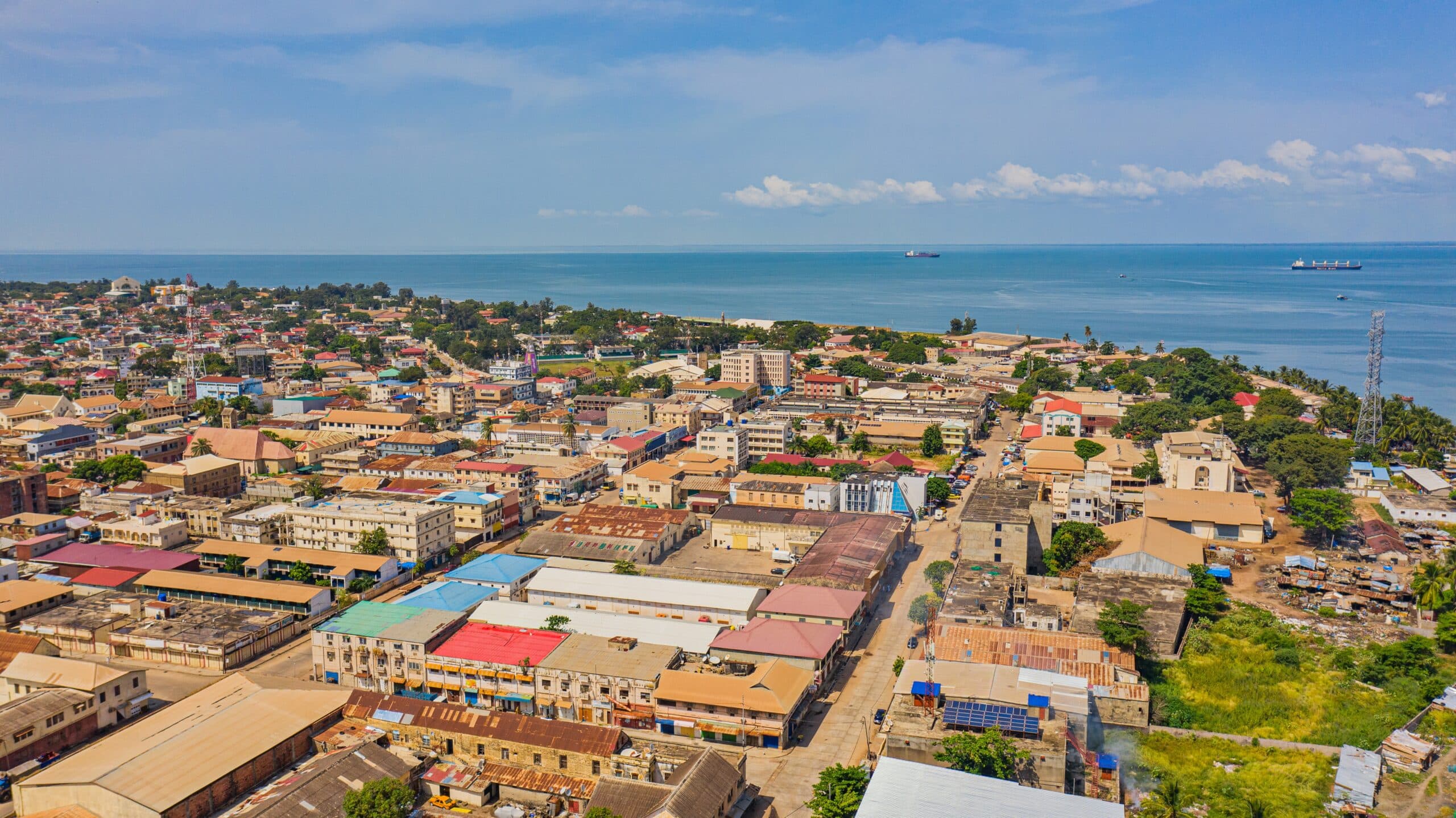
25. Banjul: Capital at the Mouth of the River
Banjul stands where the Gambia River meets the Atlantic Ocean, occupying a position shaped by passage rather than dominance. As one of Africa’s smallest capitals, it reflects governance built on accessibility, proximity, and restraint.
Surrounded by water and mangroves, the city functions as both administrative center and maritime gateway. Ferries move constantly between Banjul and surrounding settlements, reinforcing movement as part of daily life. The capital remains physically and socially connected to the nation it serves.
Colonial-era structures coexist with markets, mosques, and residential neighborhoods, creating a cityscape where history remains visible but unassertive. Economic life unfolds at street level—fish markets, produce stalls, and small shops sustain livelihoods without spectacle.
Social rhythm in Banjul is calm and measured. Religious institutions share space peacefully, and governance feels present rather than distant. The city’s modest scale allows personal interaction between citizens and institutions, reinforcing trust and familiarity.
The Arch 22 monument rises above the city as a symbolic overview. From its height, river, sea, and settlement merge into a single frame, reflecting the country’s compact coherence.
Banjul represents The Gambia’s political identity expressed through humility. It is a capital that serves rather than commands, shaped by water, continuity, and human scale. In its restraint, Banjul reflects a nation comfortable with balance and proportion.
24. Bakau and Kachikally: Sacred Tradition in Living Space
Bakau stretches along the Atlantic coast as a dense urban community shaped by fishing, trade, and long-established settlement. Within its neighborhoods lies Kachikally Crocodile Pool, one of The Gambia’s most spiritually significant sites.
The pool is sacred, associated with fertility, healing, and ancestral protection. Crocodiles live here not as captive attractions but as revered guardians. Interaction is guided by belief rather than control, demonstrating a rare form of coexistence rooted in tradition.
Kachikally remains integrated into everyday life. Local residents visit for ritual purposes alongside travelers, reinforcing authenticity rather than performance. A small museum contextualizes the site within Mandinka cosmology, emphasizing continuity between belief and environment.
Bakau itself reflects social density shaped by cooperation. Fishing livelihoods, markets, and transport create constant interaction, reinforcing communal responsibility. The town operates through familiarity, where shared knowledge supports resilience.
Kachikally illustrates how spirituality can function as conservation. Sacred status protects life without enforcement, ensuring survival through respect. This model reflects broader Gambian values, where belief systems reinforce ecological balance.
Bakau represents living culture rather than preserved heritage. It shows how tradition remains relevant when embedded in daily systems. Here, sacred and ordinary coexist naturally, reinforcing identity through practice rather than display.
23. Tanji Fishing Village: Atlantic Labor and Collective Rhythm
Tanji lies along The Gambia’s Atlantic coast as one of the country’s most active fishing communities, defined by labor, cooperation, and ocean-driven rhythm. The sea here is not scenery—it is sustenance.
Fishing boats return daily from open water, bringing catches that are immediately processed through coordinated effort. Sorting, smoking, drying, and trading involve entire families, with women playing central roles in sustaining household economies and food distribution networks.
The shoreline is animated yet structured. Work follows routines refined over generations, where timing, trust, and shared responsibility ensure continuity. Collective labor reinforces identity built on contribution rather than competition.
Tanji’s harbor supplies markets across the country, linking coastal resources with inland communities. The village functions as a national artery, supporting food security through discipline and cooperation.
Environmental awareness is embedded in practice. Fishermen understand seasonal cycles and limits, adapting techniques to preserve future yield. Knowledge is transmitted orally, reinforcing respect for the ocean as a living system.
Tanji represents The Gambia’s working coastline. It shows how tradition and economy intertwine without romanticism. In this village, resilience is practiced daily through repetition, cooperation, and respect for forces larger than human ambition.
22. Kiang West National Park: Mangroves, River, and Stillness
Kiang West National Park stretches along the lower Gambia River as a protected landscape of mangroves, savannah, and wetlands. Quiet and expansive, it forms an ecological backbone for the country’s riverine system.
The park supports diverse birdlife, primates, reptiles, and plant species adapted to tidal movement and seasonal flooding. Water governs life here, shaping migration, breeding, and vegetation patterns.
Human access remains limited and deliberate. Community-based conservation ensures that protection aligns with livelihood rather than exclusion. Fishing and harvesting follow regulated systems built on shared responsibility.
Kiang West’s defining quality is stillness. Canoes move slowly through mangrove channels, and observation replaces intervention. The park does not impress through spectacle, but through continuity.
Ecologically, it stabilizes surrounding environments, protecting coastlines, supporting fisheries, and filtering water systems. Its influence extends beyond its borders.
Kiang West represents The Gambia’s environmental core. It demonstrates how conservation rooted in proximity and respect sustains both nature and community. Here, protection is quiet, deliberate, and enduring.
21. Janjanbureh (Georgetown): Island of Memory and Continuity
Janjanbureh lies on an island in the middle of the Gambia River, positioned deep within the country’s interior. Formerly known as Georgetown, it has long served as an administrative, commercial, and cultural anchor linking riverine communities.
The island’s geography defines its rhythm. Surrounded by slow-moving water, life here unfolds deliberately. Ferries and small boats connect Janjanbureh to surrounding villages, reinforcing the river’s role as connector rather than barrier. Movement is constant but unhurried.
Historically, Janjanbureh played a central role in trade and governance during the colonial era. Remnants of administrative buildings and river infrastructure remain, yet the town’s significance today lies more in continuity than preservation. The island has adapted without abandoning its core identity.
Agriculture and fishing sustain livelihoods, shaped by seasonal flooding and fertile soil. Rice fields, gardens, and river harvests support local food systems, reinforcing self-reliance. Knowledge of land and water is transmitted through practice rather than instruction.
Social life is deeply communal. Elders hold authority through experience, while storytelling maintains collective memory. Religious practice blends seamlessly into daily routines, reinforcing cohesion rather than hierarchy.
Janjanbureh represents The Gambia’s interior soul. It shows how identity persists through adaptation rather than expansion. Anchored by water and memory, the island reflects a nation shaped by patience, resilience, and continuity along the river that binds it together.
20. Tendaba and the Central River Region: Where Nature and Village Align
Tendaba sits along the south bank of the Gambia River within the Central River Region, an area defined by wetlands, savannah, and deeply rooted rural life. The village serves as a gateway to surrounding ecosystems while remaining firmly grounded in tradition.
The river dominates daily existence. Fishing, transport, and agriculture depend on its cycles, reinforcing close attention to seasonal change. Mangroves and tidal channels create habitats for fish and birds, sustaining both ecology and economy.
Villages here maintain strong communal organization. Farming is collective, labor is shared, and resources are managed through consensus. This social structure ensures resilience in an environment shaped by uncertainty.
Wildlife exists in proximity rather than separation. Monkeys, birds, and reptiles move freely through village edges, reinforcing coexistence rather than conflict. Conservation here is informal yet effective, guided by necessity and inherited knowledge.
Tendaba reflects a balanced relationship between people and environment. Lodges and visitors remain secondary to village life, ensuring that outside presence adapts to local rhythm rather than altering it.
The Central River Region represents The Gambia’s rural foundation. It shows how sustainability emerges naturally when communities remain attentive to land and water. Here, survival and stewardship are inseparable, practiced daily through restraint, cooperation, and respect for the river’s authority.
19. Abuko Nature Reserve: Conservation at Human Scale
Abuko Nature Reserve lies near the coastal corridor as The Gambia’s oldest protected area, demonstrating how conservation can function within reach of urban life. Small in size yet significant in impact, it protects a vital slice of forest and wetland ecosystem.
The reserve shelters monkeys, reptiles, birds, and diverse plant species adapted to freshwater and woodland environments. Narrow trails guide visitors quietly through shaded corridors, emphasizing observation rather than intrusion.
Abuko’s importance lies in accessibility. Proximity to towns allows education, awareness, and connection to nature for Gambians who might otherwise be separated from wildlife. Conservation here is participatory rather than distant.
Management prioritizes restraint. Visitor numbers are controlled, and intervention remains minimal. The reserve’s success depends on balance—protecting ecosystems while remaining open to learning.
Abuko represents The Gambia’s environmental consciousness expressed practically. It shows that protection does not require vast distance or isolation. When care is localized and intentional, conservation becomes part of daily life rather than an abstract ideal.
18. Kunta Kinteh Island: Silence and Reflection on the River
Kunta Kinteh Island lies within the Gambia River as a place of historical gravity and collective reflection. Once a holding point during the transatlantic slave trade, the island stands today as a site of memory rather than explanation.
The island’s ruins remain sparse. Stone walls, foundations, and eroded structures speak quietly, allowing space for contemplation. The river flows steadily around it, reinforcing continuity beyond trauma.
Visiting the island requires crossing water, a symbolic passage that reinforces separation between past and present. Silence dominates, encouraging reflection rather than narration.
Kunta Kinteh Island holds national and global significance, yet it avoids dramatization. Memory here is preserved through restraint, allowing dignity to guide interpretation.
The island represents The Gambia’s role in global history acknowledged with humility. It stands as a reminder that memory must be held carefully, allowing space for understanding, respect, and continuity.
17. Farafenni: Northern Gateway of Exchange
Farafenni sits near The Gambia’s northern border as a town shaped by movement, trade, and transition. Positioned along a major crossing route between Senegal and the river interior, it functions as a gateway rather than a terminus.
The town’s identity is inseparable from circulation. Markets draw traders from surrounding regions, while transport routes funnel goods, livestock, and people through its streets. This constant flow sustains Farafenni’s economy and reinforces its outward-facing character.
Daily life revolves around exchange. Produce, textiles, and household goods change hands through negotiation rooted in familiarity and trust. The market is not only commercial but social, serving as a meeting point where news, tradition, and obligation circulate alongside goods.
Farafenni’s population reflects ethnic and cultural diversity shaped by border proximity. Languages, customs, and livelihoods overlap naturally, reinforcing tolerance through necessity rather than ideology. Difference here is functional, not divisive.
The surrounding landscape is dry and open, reinforcing reliance on trade rather than agriculture alone. Seasonal rhythms influence availability and movement, demanding adaptability from residents.
Farafenni represents The Gambia’s northern interface. It shows how border towns can function as connectors rather than margins. Through exchange and interaction, the town sustains cohesion across regions, demonstrating that identity is strengthened—not diluted—by movement.
16. Kartong: Southern Edge and Coastal Continuity
Kartong lies at The Gambia’s southernmost edge where the Atlantic coast meets the border with Senegal. Defined by fishing, wetlands, and relative isolation, it offers a quieter vision of coastal life shaped by continuity rather than expansion.
The village remains closely tied to the sea. Fishing sustains households, while mangroves and tidal flats support biodiversity essential to long-term survival. Environmental awareness here is practiced instinctively, shaped by dependence rather than policy.
Kartong’s wetlands function as natural buffers, protecting coastline and fisheries. Community-led conservation initiatives reinforce stewardship rooted in lived experience. Protection here is personal, not abstract.
Social organization remains intimate. Extended families, shared labor, and collective decision-making shape daily rhythm. Outsiders are welcomed carefully, reinforcing hospitality balanced with preservation of identity.
Kartong represents The Gambia’s southern anchor. It shows how peripheral locations can sustain stability through restraint. Here, life unfolds at the pace of tide and season, reinforcing balance between human need and ecological responsibility.
15. Lamin and the Bolong Wetlands: Living with Water
Lamin sits along tidal creeks known locally as bolongs, where mangroves and waterways dominate the landscape. These wetlands shape settlement patterns, livelihoods, and worldview.
Fishing, oyster harvesting, and small-scale agriculture sustain the community. Women play central roles in wetland economies, reinforcing social balance through labor and knowledge.
The bolongs regulate water flow, support fisheries, and protect inland areas from erosion. Lamin’s survival depends on respecting these systems rather than altering them.
Housing and movement adapt to water’s presence. Canoes remain essential, and seasonal flooding is anticipated rather than resisted. This acceptance defines Lamin’s resilience.
Lamin represents riverine adaptation. It shows how communities thrive when built around environmental reality rather than against it. Here, water is not obstacle—it is structure.
14. Barra: Ferry Town of Passage
Barra lies opposite Banjul across the river mouth, functioning as a vital ferry hub connecting capital and north bank. Its identity is shaped by waiting, movement, and exchange.
The ferry defines daily rhythm. Markets, transport services, and informal trade cluster around arrival points. Barra exists in anticipation, structured around transition rather than permanence.
Despite constant movement, the town maintains strong social cohesion. Families, traders, and transport workers rely on familiarity and routine to manage unpredictability.
Barra represents The Gambia’s threshold spaces—places where patience, adaptability, and connection define survival. It shows how waiting itself becomes a form of labor.
13. Tendaba Wetlands Extension: Where River Widens
Beyond the village, the Tendaba wetlands stretch outward as a vast riverine ecosystem supporting fish nurseries, migratory birds, and floodplain agriculture. This wider landscape reinforces the Central River Region’s ecological importance.
Seasonal flooding renews soil fertility, enabling farming without intensive inputs. Communities adapt schedules and movement accordingly, reinforcing coexistence with natural cycles.
Birdlife dominates skies and waterways, making the wetlands vital for regional biodiversity. Human presence remains light, guided by inherited restraint.
This extended landscape represents The Gambia’s ecological continuity. It shows how protection emerges when people remain attentive to rhythm rather than control.
12. Niumi National Park: Mangroves at the Nation’s Edge
Niumi National Park occupies The Gambia’s westernmost edge, where the river opens into the Atlantic and land dissolves into mangrove, mudflat, and tidal creek. This liminal landscape defines the country’s first and last impression, shaped by water, salt, and movement.
The park protects critical ecosystems that stabilize coastlines and sustain fisheries. Mangroves act as nurseries for fish and crustaceans, while mudflats support migratory birds traveling vast intercontinental routes. Life here depends on rhythm rather than permanence.
Human presence exists through proximity, not intrusion. Nearby communities rely on the park’s health for fishing and harvesting, reinforcing stewardship born of necessity. Conservation is practical, guided by lived dependence rather than abstraction.
Movement dominates the landscape. Tides advance and retreat, reshaping channels daily. Boats navigate narrow waterways with precision learned over generations. Nothing here is fixed; adaptation defines survival.
Niumi represents The Gambia’s environmental threshold. It shows how national identity begins not at borders drawn on land, but at ecosystems that sustain life beyond visibility. At this edge, the country reveals its commitment to balance between use and protection, reinforcing continuity through restraint.
11. Wassu Stone Circles: Geometry of Ancestral Memory
Wassu lies inland along the north bank of the Gambia River, home to one of West Africa’s most significant prehistoric monuments. The stone circles rise quietly from open land, arranged with precision that reflects ancient cosmology rather than decoration.
These stones mark burial sites dating back over a millennium, constructed through collective effort and long-term planning. Their alignment suggests knowledge of time, movement, and ritual beyond written record.
The surrounding village maintains a respectful relationship with the site. The stones are not isolated from daily life; they exist within agricultural fields and footpaths, reinforcing continuity between ancestors and present community.
Interpretation here is minimal. Silence allows meaning to emerge through observation rather than explanation. The stones command attention through endurance rather than scale.
Wassu represents The Gambia’s deep temporal dimension. It reveals a nation whose history extends far beyond colonial timelines, grounded in ancestral knowledge of land and memory. The circles remind visitors that identity is shaped not only by movement, but by what remains.
10. Brikama: Craft, Sound, and Urban Rhythm
Brikama stands inland as one of The Gambia’s largest towns, defined by craft, music, and dense urban life. Unlike coastal settlements shaped by trade routes, Brikama grew through internal exchange and artisanal tradition.
The town is renowned for craftsmanship, particularly wood carving and instrument making. Workshops operate openly, allowing skill transmission through observation and repetition. Creation here is functional, cultural, and economic.
Music flows through Brikama’s streets. Drumming, kora melodies, and rehearsal spaces reinforce sound as social glue. Performance is not staged; it is practiced daily.
Markets anchor the town’s rhythm, supplying goods to surrounding regions. Despite its size, Brikama maintains communal familiarity, shaped by shared labor and lineage.
Brikama represents The Gambia’s creative core. It shows how urban growth can sustain tradition rather than erase it. In sound and craft, the town expresses continuity through making rather than monument.
9. River Villages of Lower Saloum: Life Between Banks
Along the lower stretches of the Gambia River, small villages cluster close to water, shaped by fishing, farming, and seasonal movement. These settlements operate through attentiveness rather than infrastructure.
Homes face the river, reinforcing dependence and orientation. Canoes serve as transport, storage, and livelihood. Daily routines align with water level and current.
Social organization is collective. Labor is shared, decisions are communal, and survival depends on cooperation. External presence remains minimal, preserving internal rhythm.
These villages represent The Gambia in its most elemental form. They reveal how life organized around water fosters resilience, patience, and continuity.
8. Juffureh and Albreda: Villages of Shared History
Juffureh and Albreda sit along opposite banks of the Gambia River as small villages bound to global history through local experience. Their significance is not expressed through scale or monument, but through memory carried quietly within place.
Juffureh is widely associated with ancestral narratives of the transatlantic slave trade, yet it remains first and foremost a living village. Daily life revolves around farming, fishing, and family structure. Memory here is not abstract; it is embedded within lineage, oral history, and land.
Across the river, Albreda developed historically as a trading post influenced by European presence. Architectural remnants reflect exchange and encounter rather than dominance. Today, the village exists through continuity, not preservation, balancing livelihood with remembrance.
The river connects the two settlements, reinforcing movement as shared condition. Canoes and ferries sustain interaction, reminding residents that history unfolded along water, not borders.
Interpretation of the past is measured. Museums and storytelling exist, but restraint allows dignity to guide understanding. Reflection is encouraged rather than directed.
Juffureh and Albreda represent The Gambia’s approach to difficult history—acknowledgment without spectacle. They show how memory can be preserved through lived continuity, allowing communities to remain rooted while carrying stories that extend far beyond the river’s banks.
7. Sanyang and the Coastal Forests: Edge of Sand and Green
Sanyang lies along the Atlantic coast where forest meets shoreline, forming a transitional landscape shaped by restraint rather than development. Unlike heavily urbanized beaches, this stretch remains defined by vegetation, community, and continuity.
The coastal forests stabilize dunes and protect inland settlements. Palms, scrub, and mangrove systems regulate erosion while supporting birdlife and small fauna. Environmental balance here is visible and functional.
Fishing and small-scale trade sustain livelihoods. The beach operates as workspace, not resort, reinforcing practical connection to the ocean. Community presence discourages overexploitation through shared responsibility.
Sanyang’s growth remains measured. Guesthouses and visitors exist, but local rhythm governs interaction. External presence adapts to place rather than altering it.
The forest-beach interface creates natural calm. Sound softens, light filters through foliage, and movement slows. Observation replaces urgency.
Sanyang represents The Gambia’s capacity for coastal preservation through moderation. It shows how landscapes remain resilient when development follows community pace. At this edge of sand and green, balance becomes both practice and principle.
6. Soma: Inland Market of River and Road
Soma stands at a strategic crossing point where river transport meets inland roads, forming one of The Gambia’s most important commercial junctions. The town’s identity is shaped by coordination rather than display.
Markets dominate daily life. Agricultural produce, livestock, and goods converge here before dispersing across regions. Trade sustains the town’s vitality and reinforces its role as intermediary.
Transport defines Soma’s rhythm. Trucks, ferries, and foot traffic intersect continuously, demanding organization and adaptability. Movement is expected, not disruptive.
Despite commercial intensity, social cohesion remains strong. Ethnic diversity coexists through shared economic purpose. Familiarity governs exchange, reinforcing trust across difference.
Soma’s surrounding countryside depends on the town for access and distribution. In turn, the town relies on rural production, reinforcing interdependence.
Soma represents The Gambia’s logistical heart. It shows how connectivity sustains cohesion, linking river and land into a functional whole. Through movement and exchange, Soma maintains balance between progress and continuity.
5. Bintang Bolong: Wetland of Reflection
Bintang Bolong lies along a tidal creek branching from the Gambia River, surrounded by mangroves and open water. This quiet wetland landscape emphasizes stillness and ecological interdependence.
Water defines space here. Channels shift with tides, reshaping access and visibility. Birdlife dominates soundscape, reinforcing the wetland’s role as refuge and nursery.
Fishing and small-scale harvesting occur with care. Knowledge of seasons governs activity, ensuring sustainability through restraint. Human presence adapts rather than imposes.
Bintang Bolong’s isolation encourages reflection. Movement slows, and attention sharpens. Observation replaces consumption.
The bolong represents The Gambia’s reflective dimension. It shows how environments invite patience, reinforcing respect for rhythm rather than control. Here, balance is not managed—it is lived.
4. Gunjur: Coastal Community and Environmental Resolve
Gunjur lies along the Atlantic coast in southern Gambia as a town defined by strong civic identity and environmental awareness. Fishing, farming, and small-scale trade sustain livelihoods, while community organization shapes decision-making.
The coastline here reflects both abundance and vulnerability. Fishing remains central, yet residents are acutely aware of pressure on marine resources. This awareness has fostered grassroots environmental movements that prioritize long-term sustainability over short-term gain.
Gunjur’s strength lies in collective action. Local associations address waste management, coastal protection, and youth engagement, reinforcing responsibility as shared obligation. Environmental stewardship is not framed as activism alone, but as preservation of livelihood and identity.
Social life remains deeply communal. Markets, mosques, and meeting spaces anchor daily interaction, reinforcing familiarity across generations. Youth involvement in civic initiatives reflects continuity rather than rupture.
The surrounding landscape blends beach, forest, and agricultural land, reinforcing interdependence between ecosystems. Seasonal cycles dictate work patterns, maintaining alignment with natural rhythms.
Gunjur represents The Gambia’s capacity for self-determination at local scale. It shows how communities can respond proactively to environmental and economic challenges without losing cohesion. In Gunjur, resilience is practiced through participation, restraint, and shared accountability.
3. Basse Santa Su: Eastern Capital of the River
Basse Santa Su sits in the Upper River Region as the easternmost major town in The Gambia. Positioned along the river’s inland stretch, it anchors administration, trade, and culture in a region shaped by distance and continuity.
The river remains central to Basse’s identity. Agriculture depends on seasonal flooding, while transport and trade follow riverine routes linking villages across wide distances. Movement here is purposeful, shaped by necessity rather than speed.
Markets sustain the town’s vitality. Grains, livestock, and produce converge from surrounding rural areas, reinforcing Basse’s role as regional hub. Exchange supports cohesion across dispersed settlements.
Cultural life reflects strong Mandinka traditions. Music, storytelling, and religious practice reinforce continuity, while elders guide social structure through experience. Modern influences exist, but adaptation occurs without erasure.
Basse’s pace is steady. Infrastructure develops gradually, aligned with regional needs rather than external demand. The town remains rooted in service rather than expansion.
Basse Santa Su represents The Gambia’s eastern anchor. It shows how distance from coast and capital fosters independence without isolation. Through river, land, and tradition, Basse sustains identity deep within the country’s interior.
2. Kerewan: Groundnut Basin and Rural Stability
Kerewan lies within the North Bank Region as a center of agricultural production, historically associated with groundnut farming. The surrounding plains shape livelihoods defined by patience, planning, and seasonal awareness.
Farming governs daily life. Planting and harvest cycles dictate movement, labor, and social organization. Cooperation ensures efficiency, reinforcing shared responsibility across families and villages.
Markets connect rural production to national networks. Groundnuts, grains, and produce move through Kerewan, sustaining regional economy. Trade here remains practical rather than speculative.
Social structure emphasizes continuity. Elders guide decisions, while younger generations inherit responsibility through participation. Knowledge of land, weather, and soil is transmitted through practice.
The landscape appears open and unassuming, yet it requires attentiveness. Rainfall variability demands adaptation, reinforcing resilience through experience.
Kerewan represents The Gambia’s agricultural backbone. It shows how food security and social stability emerge from collective labor aligned with land. In Kerewan, endurance is quiet, grounded, and essential.
1. River Islands of the Upper Gambia: Scattered Anchors
Along the upper reaches of the Gambia River, small islands emerge as scattered anchors within flowing water. These islands support farming, fishing, and seasonal settlement, shaping micro-communities defined by adaptation.
Access depends on water level. Canoes and shallow boats connect islands to mainland villages, reinforcing movement as condition of life. Isolation is temporary, governed by season.
Farming occurs on fertile soils renewed by floods. Rice and vegetables thrive, sustaining households through careful timing and shared labor.
Social life remains tightly knit. Island communities rely on trust and cooperation, reinforcing bonds through proximity and necessity. External presence remains rare, preserving internal rhythm.
These islands represent The Gambia’s most distilled expression of river-based living. They show how settlement adapts fluidly to environment, reinforcing resilience through acceptance rather than control.