
Pakistan occupies a diverse geographic position in South Asia, bordered by Afghanistan, Iran, India, and China, with a southern coastline along the Arabian Sea. Its terrain encompasses towering mountains in the north, fertile plains along the Indus River, arid plateaus in the west, and coastal delta regions in the south.
Northern Pakistan is dominated by the Himalaya, Karakoram, and Hindu Kush ranges, containing some of the world’s highest peaks, including K2. Geography here is rugged, glaciated, and tectonically active, producing valleys, rivers, and alpine ecosystems that support both human settlement and unique biodiversity.
The Indus River and its tributaries shape the central plains, creating fertile floodplains that sustain Pakistan’s dense population and agricultural economy. Seasonal monsoon rainfall and river flooding have historically dictated settlement patterns, irrigation practices, and urban growth.
Western Pakistan transitions into the arid and semi-arid Balochistan Plateau, characterized by deserts, rocky hills, and sparse vegetation. Water scarcity and extreme temperatures define human adaptation in this region.
The southern coastline along the Arabian Sea, including the Indus Delta, supports mangroves, fisheries, and port cities like Karachi. Geography here combines tidal influences, sediment deposition, and tropical aridity, creating a unique coastal ecosystem.
Pakistan’s geographic diversity — from glacial mountains to fertile plains, deserts, and coastal zones — has shaped its cultural, economic, and historical development. Trade routes, ancient civilizations, and modern cities all reflect human adaptation to varied terrain.
In the chapters ahead, Pakistan will be explored through its major geographic regions: the northern mountains, the Indus plains, the western plateaus, and the southern coastal zones — revealing a country whose identity is inseparable from its mountains, rivers, and deserts.
21. Hunza Valley

Hunza Valley lies in northern Pakistan within Gilgit-Baltistan, surrounded by the towering peaks of the Karakoram Range. Geography here is high-altitude mountain valley shaped by tectonic uplift, glacial carving, and river erosion.
The valley follows the Hunza River, which cuts through steep rock walls and terraced slopes. Snow-fed glaciers descending from surrounding peaks, including Rakaposhi and Ultar Sar, sustain perennial water flow. Geography reinforces agricultural adaptation through terracing, where apricot orchards and small grain fields cling to steep mountainsides.

Elevations range from roughly 2,000 meters in the valley floor to over 7,000 meters in surrounding summits. The climate is alpine, with cold winters and mild summers. Limited arable land has historically required efficient irrigation systems channeling glacial meltwater across terraced fields.
The region lies along the historic Silk Road corridor connecting South Asia to Central Asia and China. Geography shaped trade routes through high mountain passes, reinforcing cultural exchange and strategic importance.

Endurance here is glacial and tectonic. Mountain landscapes are dynamic, with landslides, glacial movement, and seismic activity influencing settlement patterns. Sustainable tourism and environmental stewardship are essential to preserve fragile alpine ecosystems.
Hunza Valley reflects Pakistan’s northern high-mountain geography — dramatic, elevated, and shaped by ice and rock. Visitors encounter sharp peaks, turquoise rivers, and terraced agriculture, illustrating how communities adapt to extreme elevation while maintaining harmony with glacial landscapes.
20. Lahore
Lahore is located in northeastern Pakistan along the fertile plains of the Ravi River, one of the major tributaries of the Indus system. Geography here is alluvial lowland characterized by flat terrain, rich soils, and monsoon-influenced agriculture.
The Ravi’s historic floodplain created fertile ground for settlement, enabling Lahore to grow into one of South Asia’s major cultural and urban centers. Irrigation canals branching from the Indus system support extensive cultivation of wheat, rice, and sugarcane in the surrounding countryside.
The climate is subtropical, with hot summers, monsoon rains between July and September, and mild winters. Geography requires adaptation to seasonal flooding and intense heat. Urban design historically incorporated courtyards, shaded bazaars, and thick masonry walls to mitigate high temperatures.
The city lies near historic overland trade routes linking Central Asia to the Indian subcontinent. Geography reinforced Lahore’s strategic position as a gateway between regions, supported by the productivity of its agricultural hinterland.
Endurance here is fluvial and climatic. Sustainable development depends on effective river management, groundwater conservation, and mitigation of monsoon flooding. Soil fertility remains a central geographic asset.
Lahore reflects Pakistan’s Indus plain geography — fertile, densely settled, and shaped by river systems. Visitors encounter a landscape defined by agricultural abundance and monsoon rhythms, demonstrating how the Indus basin remains the country’s demographic and cultural heartland.
19. Mohenjo-daro
Mohenjo-daro lies in Sindh Province near the Indus River. Geography here is low-lying floodplain formed by centuries of sediment deposition from the Indus system.
Founded around 2500 BCE, Mohenjo-daro developed within one of the world’s earliest urban civilizations. The Indus River provided fertile soils and reliable water supply, enabling large-scale agriculture and urban planning. Geography reinforced grid-based city layout and sophisticated drainage systems designed to manage seasonal flooding.
The terrain is flat and expansive, with minimal natural elevation. To protect against river overflow, sections of the city were built on raised platforms. Geography required precise water control — too much water threatened structural stability, while insufficient irrigation risked crop failure.
The climate is hot semi-arid, with intense summer heat and limited rainfall. River proximity moderated agricultural potential but also introduced risks of salinity and sediment shifts as river channels migrated over time.
Geologically, the region consists of fine alluvial silt, making mudbrick the primary building material. Over centuries, shifting Indus courses gradually altered the site’s accessibility and contributed to its decline.
Endurance here is fluvial and environmental. Preservation today must contend with rising groundwater, salinity, and erosion of ancient mudbrick structures in a fragile floodplain ecosystem.
Mohenjo-daro reflects Pakistan’s southern Indus basin geography — a civilization born directly from river sediment and hydraulic ingenuity. Visitors encounter the remnants of a meticulously planned city, demonstrating how early urban life thrived in harmony with one of South Asia’s most powerful river systems.
18. Skardu
Skardu lies in northern Pakistan within Gilgit-Baltistan, positioned at the confluence of the Indus and Shigar Rivers. Geography here is dramatic high-altitude basin surrounded by the Karakoram Mountains, with peaks rising above 7,000 meters.
The Skardu Valley sits at approximately 2,500 meters above sea level. Glaciers descending from nearby massifs, including the Baltoro Glacier system, feed the Indus River, reinforcing the region’s hydrological significance. Geography shapes both agriculture and settlement through meltwater irrigation supporting barley, wheat, and orchards.
The terrain combines broad alluvial plains within the basin and steep rocky slopes surrounding it. Seasonal extremes define the climate — cold winters with snowfall and relatively mild summers. Limited precipitation makes glacial runoff essential for sustaining life.
Skardu serves as a gateway to some of the world’s highest peaks, including K2, located further north in the Karakoram Range. Geography reinforces its role as a staging point for mountaineering expeditions and high-altitude trekking routes.
Endurance here is glacial and tectonic. The region lies within an active seismic zone shaped by the collision of the Indian and Eurasian plates. Landslides, glacial lake outburst floods, and rockfall present natural hazards.
Skardu reflects Pakistan’s extreme northern mountain geography — vast, elevated, and glacially carved. Visitors encounter sweeping valleys framed by jagged summits, demonstrating how alpine ecosystems and snow-fed rivers define the upper Indus watershed.
17. Karachi
Karachi is Pakistan’s largest city, located along the Arabian Sea coast in Sindh Province. Geography here is coastal plain shaped by marine processes, deltaic sediment, and arid subtropical climate.
Situated west of the Indus Delta, Karachi occupies a relatively dry coastal stretch characterized by sandy beaches, rocky outcrops, and shallow bays. The Arabian Sea moderates temperatures compared to inland desert regions, though summers remain hot and humid.
The coastline supports Pakistan’s primary seaport, linking the country to global maritime trade routes. Geography reinforces Karachi’s economic centrality, as deep-water access and proximity to shipping lanes make it a natural maritime hub.
Rainfall is limited and irregular, mostly arriving during the monsoon season. Freshwater availability depends on pipelines and reservoirs fed by the Indus River system. Geography therefore requires careful water resource management in an arid coastal environment.
The surrounding terrain consists of low hills composed of sedimentary rock, providing natural drainage but also limiting groundwater reserves. Coastal mangroves in nearby delta regions play an essential role in protecting against erosion and storm surges.
Endurance here is coastal and climatic. Sustainable urban growth must address sea-level rise, coastal erosion, and freshwater scarcity.
Karachi reflects Pakistan’s maritime geography — where desert plains meet the Arabian Sea. Visitors encounter a landscape shaped by tides, trade winds, and port infrastructure, illustrating how coastal positioning has made the city Pakistan’s economic gateway to the world.
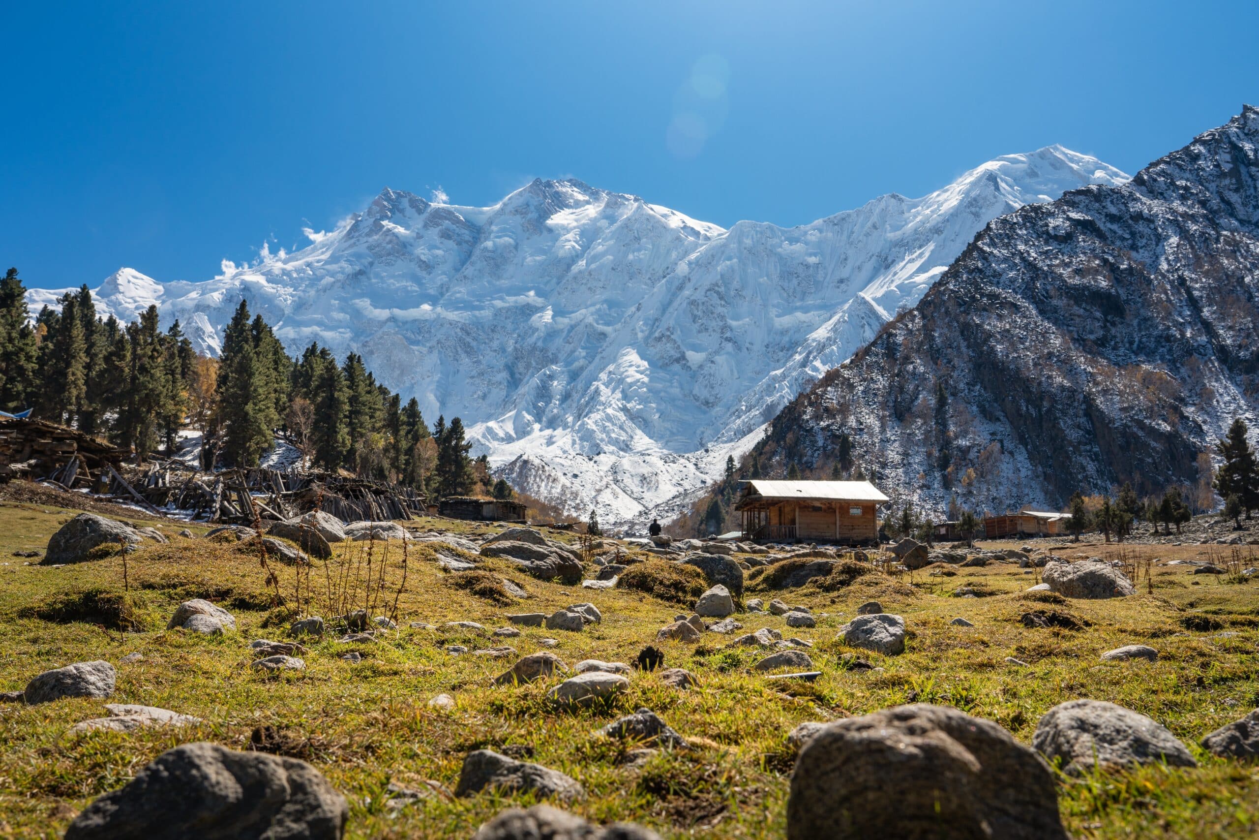
16. Fairy Meadows
Fairy Meadows is a high-altitude alpine meadow located near the base of Nanga Parbat in northern Pakistan. Geography here is defined by dramatic vertical relief, dense pine forests, and glacial proximity.
Situated at approximately 3,300 meters above sea level, the meadow overlooks the Raikot Glacier and the towering slopes of Nanga Parbat, the ninth-highest mountain in the world. The surrounding terrain is part of the western Himalayas, shaped by tectonic uplift and glacial erosion.
The climate is alpine, with cool summers and harsh winters. Snowfall blankets the region for much of the year, while short growing seasons allow grasses and wildflowers to flourish in summer months. Geography supports pastoral grazing during warmer seasons.
The meadow rests on relatively gentle terrain compared to the surrounding steep mountain faces. This natural plateau provides rare open space in an otherwise rugged landscape. Snowmelt streams nourish forested slopes below.
Geologically, the area reflects the immense forces generated by the collision of the Indian and Eurasian tectonic plates. Rock faces, ice fields, and glacial valleys dominate the horizon.
Endurance here is glacial and ecological. The fragile alpine ecosystem depends on controlled tourism and protection against deforestation. Climate change influences glacial stability and seasonal snow cover.
Fairy Meadows reflects Pakistan’s high Himalayan geography — pristine, elevated, and glacially sculpted. Visitors encounter panoramic views of massive peaks and ice fields, illustrating how mountain landscapes dominate northern Pakistan’s environmental identity.
15. Islamabad
Islamabad is located in northern Pakistan at the foothills of the Margalla Hills, where the Pothohar Plateau transitions into the lower Himalayas. Geography here combines rolling uplands, forested ridges, and seasonal streams.
The city sits at approximately 540 meters above sea level, enjoying a slightly cooler climate than the southern plains. The Margalla Hills to the north form a natural barrier and part of the Himalayan foothill system. These limestone ridges influence drainage patterns, channeling rainwater into streams that feed Rawal Lake and surrounding reservoirs.
Islamabad’s terrain is gently undulating, with planned urban sectors aligned to natural contours. Geography influenced its selection as the national capital in the 1960s, offering a more temperate environment and defensible positioning compared to lowland cities.
The climate is humid subtropical, with hot summers, monsoon rains, and mild winters. Seasonal rainfall sustains surrounding forests and supports limited agriculture on the plateau.
Geologically, the region reflects uplift from the ongoing collision between the Indian and Eurasian plates. Erosion over time carved valleys and shaped the scenic hill backdrop.
Endurance here is climatic and hydrological. Sustainable urban growth depends on watershed protection, forest conservation, and careful groundwater management.
Islamabad reflects Pakistan’s northern transitional geography — bridging fertile plains and rising mountains. Visitors encounter a landscape of green hills and structured urban planning, illustrating how geography influenced the capital’s placement at the gateway to the Himalayas.
14. Gwadar
Gwadar lies on Pakistan’s southwestern Arabian Sea coast in Balochistan Province. Geography here is coastal desert, defined by rocky headlands, arid hills, and a hammerhead-shaped peninsula projecting into the sea.
The surrounding terrain consists of barren mountains and sandy plains shaped by tectonic uplift and marine erosion. Gwadar’s natural deep-water harbor gives it strategic maritime significance, as it sits near vital shipping lanes linking the Middle East with South Asia.
The climate is hot desert with strong coastal influence. Rainfall is scarce, and freshwater availability is limited. Geography requires desalination, reservoirs, and water transport systems to sustain urban expansion.
Coastal currents and tidal action shape the shoreline, creating sandy beaches and fishing zones. The arid hinterland contrasts sharply with the open Arabian Sea, highlighting Pakistan’s geographic diversity.
Geologically, the Makran Coastal Range nearby reflects subduction-related tectonic activity where the Arabian Plate moves beneath the Eurasian Plate. This tectonic setting contributes to seismic vulnerability and rugged coastal landscapes.
Endurance here is coastal and climatic. Long-term sustainability depends on water security, shoreline protection, and adaptation to rising sea levels.
Gwadar reflects Pakistan’s southwestern maritime geography — stark desert meeting open sea. Visitors encounter windswept hills and expansive horizons, illustrating how coastal positioning shapes economic opportunity and environmental challenge in Pakistan’s most remote province.
13. Multan
Multan is situated in southern Punjab along the fertile plains of the Chenab River, a major tributary of the Indus. Geography here is classic Indus basin lowland, defined by flat alluvial soils and extensive irrigation networks.
The Chenab River historically deposited nutrient-rich sediment across the floodplain, enabling large-scale agriculture. Wheat, cotton, and mango orchards thrive in this region due to fertile soils and canal irrigation branching from the Indus system.
The climate is hot semi-arid, with extremely high summer temperatures and limited winter rainfall. Monsoon rains contribute seasonal moisture but can also cause localized flooding. Geography requires efficient canal management to balance water distribution and prevent salinity buildup.
The surrounding terrain is expansive and level, allowing urban growth across broad plains. Multan’s location near historical trade routes linking Central Asia with the Indian subcontinent reinforced its importance as a regional center.
Geologically, the area consists primarily of river-deposited silt and clay, making mudbrick a traditional construction material. Shifting river channels over centuries have reshaped parts of the surrounding landscape.
Endurance here is fluvial and agricultural. Sustainable development depends on maintaining Indus water flow and preventing groundwater depletion. Soil health remains essential to the region’s economy.
Multan reflects Pakistan’s southern Punjab geography — fertile, river-shaped, and agriculturally productive. Visitors encounter wide horizons and irrigated farmland, demonstrating how the Indus river system continues to define settlement and economic life across Pakistan’s central plains.
12. Peshawar
Peshawar lies in northwestern Pakistan near the entrance of the historic Khyber Pass, where the mountains of the Hindu Kush transition into the plains of the Indus basin. Geography here forms a strategic gateway between Central Asia and South Asia.
The city sits within the Peshawar Valley, a broad alluvial basin nourished by the Kabul River and seasonal tributaries. Fertile soils support wheat, sugarcane, and fruit cultivation, while surrounding hills create a natural enclosure around the valley.
The nearby Khyber Pass cuts through rugged mountain ridges, historically serving as one of the most significant overland corridors linking Afghanistan with the Indian subcontinent. Geography reinforced Peshawar’s importance as a trade, migration, and military route for centuries.
The climate is semi-arid with hot summers and mild winters. Rainfall occurs primarily during winter and early spring, supplemented by irrigation systems that draw from river channels.
Geologically, the region reflects tectonic uplift associated with the collision of the Indian and Eurasian plates. Folded hills and gravel plains define the valley’s perimeter.
Endurance here is strategic and hydrological. The sustainability of settlement depends on maintaining agricultural productivity and managing seasonal water flows.
Peshawar reflects Pakistan’s northwestern gateway geography — where mountain passes open into fertile plains. Visitors encounter a landscape shaped by trade routes, valley agriculture, and the enduring influence of highland corridors connecting regions.
11. Swat Valley
Swat Valley is located in northern Pakistan within the Hindu Kush foothills. Geography here is mountainous river valley carved by the Swat River through forested slopes and alpine meadows.
The valley lies at elevations ranging from 1,000 to over 3,000 meters. Snowfall in winter and glacial melt in spring feed the Swat River, sustaining fertile agricultural terraces along its banks. Geography supports orchards, wheat fields, and forest ecosystems.
Steep mountain ridges rise on both sides of the valley, creating dramatic vertical relief. These ridges are part of tectonic formations shaped by plate collision, producing folded rock layers and narrow gorges.
The climate is temperate compared to southern Pakistan, with cool winters and pleasant summers. Rainfall and snowmelt ensure more reliable water availability than in arid plains regions.
Geologically, erosion has shaped river terraces and gravel beds that define settlement zones. The valley’s relative isolation historically preserved distinct cultural landscapes while still maintaining connectivity through mountain passes.
Endurance here is fluvial and ecological. Forest preservation and watershed management are critical to prevent landslides and soil erosion in this mountainous environment.
Swat Valley reflects Pakistan’s northern mountain geography — lush, river-fed, and elevated. Visitors encounter green slopes and flowing rivers that contrast sharply with the dry lowlands, illustrating how altitude and rainfall transform the landscape.
10. Cholistan Desert
Cholistan Desert stretches across southern Punjab near the Indian border, forming part of the greater Thar Desert system. Geography here is arid plain characterized by sand dunes, sparse vegetation, and extreme temperatures.
The terrain consists of shifting dunes, clay flats, and intermittent dry riverbeds known as “hakras,” remnants of ancient river channels that once flowed through the region. Rainfall is minimal and highly irregular, occurring mainly during the monsoon season.
Temperatures rise sharply in summer, often exceeding 45°C, while winters can be surprisingly cool at night. Geography demands adaptation to water scarcity; traditional settlements rely on deep wells and seasonal rainwater storage systems.
The desert supports nomadic pastoralism, with herders moving livestock according to limited grazing availability. Vegetation includes hardy shrubs and grasses capable of surviving prolonged drought.
Geologically, the desert reflects ancient fluvial systems that dried as river courses shifted over millennia. Wind erosion continually reshapes dune formations.
Endurance here is climatic and ecological. Sustainable land use requires careful grazing management and groundwater conservation to prevent further desertification.
The Cholistan Desert reflects Pakistan’s southeastern arid geography — expansive, sun-scorched, and shaped by wind. Visitors encounter vast horizons and rolling dunes, demonstrating how environmental extremes define settlement and survival in Pakistan’s desert frontier.
9. Quetta
Quetta lies in western Pakistan within Balochistan Province, positioned in a high-altitude valley surrounded by the Toba Kakar Range. Geography here is arid mountain basin, elevated at approximately 1,680 meters above sea level.
The valley floor supports orchards and limited agriculture sustained by seasonal rainfall and underground aquifers. Unlike the Indus plains, Quetta depends primarily on groundwater and snowmelt from surrounding hills rather than major river systems.
The terrain consists of rugged mountains encircling a relatively flat basin. These ridges are part of tectonic formations shaped by the ongoing collision between the Arabian and Eurasian plates. Seismic activity is a defining geographic feature of the region.
The climate is semi-arid continental, with cold winters that can bring snowfall and hot summers moderated slightly by elevation. Limited precipitation demands careful water management to prevent aquifer depletion.
Historically, Quetta’s location near passes linking Pakistan with Afghanistan reinforced its strategic significance. Geography positioned it as a transit hub between Central Asia and South Asia through highland corridors.
Endurance here is tectonic and hydrological. Sustainable growth depends on groundwater conservation and seismic resilience in construction.
Quetta reflects Pakistan’s western highland geography — elevated, dry, and structurally complex. Visitors encounter mountain-ringed horizons and cool highland air, illustrating how altitude and tectonic forces shape life in Balochistan’s interior.
8. Khunjerab Pass
Khunjerab Pass marks the highest paved international border crossing in the world, located in northern Pakistan within Gilgit-Baltistan along the Karakoram Range. Geography here is extreme high-altitude mountain terrain exceeding 4,600 meters.
The pass forms part of the Karakoram Highway, linking Pakistan with China. Snow-capped peaks, glacial valleys, and alpine tundra dominate the landscape. The region lies within the Khunjerab National Park, where high-altitude ecosystems support rare wildlife adapted to thin air and cold temperatures.
The climate is harsh alpine, with long winters, heavy snowfall, and brief cool summers. Oxygen levels are significantly reduced at this elevation. Geography reinforces isolation, with access often restricted during winter months due to snow accumulation.
Geologically, the pass sits within a zone shaped by the convergence of the Indian and Eurasian tectonic plates. Rock formations reflect immense compressional forces, producing jagged peaks and deep valleys.
The area functions as a watershed dividing river systems flowing toward the Indus basin and those draining into Central Asia. Glacial melt contributes to the Indus River system downstream.
Endurance here is glacial and climatic. Infrastructure must withstand freezing temperatures, avalanches, and seismic activity. Environmental protection is critical to preserve fragile alpine ecosystems.
Khunjerab Pass reflects Pakistan’s extreme northern geography — elevated, rugged, and tectonically active. Visitors encounter vast mountain expanses that illustrate the dramatic topography defining Pakistan’s connection to Central Asia.
7. Thatta
Thatta is located in southern Sindh near the Indus Delta, east of Karachi. Geography here is deltaic lowland shaped by distributary channels of the Indus River and influenced by Arabian Sea tides.
The surrounding terrain consists of flat floodplains, wetlands, and mangrove ecosystems. Sediment deposition from the Indus has gradually built up this region over millennia. Agriculture depends on irrigation from river branches and seasonal freshwater flow.
The climate is hot and humid during summer, moderated by coastal breezes. Rainfall is limited but influenced by the monsoon. Salinity intrusion from tidal waters presents challenges to soil fertility and freshwater supply.
Thatta lies near the Keenjhar Lake (also known as Kalri Lake), one of Pakistan’s largest freshwater reservoirs. Geography reinforces the importance of water storage in delta environments where river discharge fluctuates seasonally.
Geologically, the delta reflects continuous interaction between fluvial sediment and marine processes. River channel migration has reshaped settlement patterns over time.
Endurance here is deltaic and hydrological. Sustainable land use depends on maintaining adequate Indus River flow to counter saltwater intrusion and preserve wetlands.
Thatta reflects Pakistan’s southern delta geography — where river and sea converge. Visitors encounter wetlands, tidal flats, and irrigated farmland, illustrating how the Indus River’s final journey to the Arabian Sea shapes life in the coastal south.
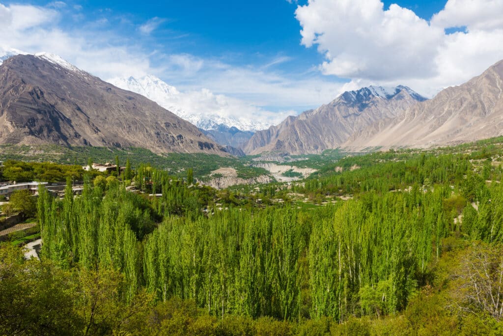
6. Gilgit
Gilgit is located in northern Pakistan at the confluence of the Gilgit and Indus Rivers. Geography here is high-altitude river valley framed by the Karakoram and western Himalaya mountain systems.
Situated at approximately 1,500 meters above sea level, Gilgit occupies a relatively broad valley floor compared to the surrounding rugged terrain. Snowmelt from glaciers in the Karakoram feeds both rivers, sustaining irrigation systems that support orchards and small-scale agriculture.
The valley lies along historic Silk Road corridors that linked South Asia with Central Asia and western China. Geography reinforced Gilgit’s role as a mountain crossroads where river routes and high passes converge.
The climate is dry continental, with cold winters and warm summers. Limited rainfall means agriculture depends heavily on glacial meltwater channeled through carefully maintained irrigation canals.
Geologically, the region is shaped by tectonic collision between the Indian and Eurasian plates. Steep rock faces, folded strata, and seismic activity characterize the broader landscape.
Endurance here is glacial and tectonic. Long-term stability depends on sustainable water management and monitoring of landslide and earthquake risks in a dynamic mountain environment.
Gilgit reflects Pakistan’s northern river-confluence geography — elevated, strategic, and defined by mountain watersheds. Visitors encounter stark rock faces and turquoise rivers, illustrating how glacial systems shape life in the upper Indus basin.
5. Hingol National Park
Hingol National Park stretches along Pakistan’s Makran Coast in Balochistan, encompassing desert plains, rugged mountains, and sections of the Arabian Sea shoreline. Geography here is coastal desert shaped by tectonic uplift and wind erosion.
The Hingol River flows intermittently through the park, carving valleys through sedimentary rock formations. The landscape features dramatic mud volcanoes, limestone cliffs, and unusual rock formations sculpted by wind and water.
Rainfall is scarce and irregular, creating an arid ecosystem adapted to extreme heat and drought. Despite harsh conditions, the park supports diverse wildlife adapted to desert and coastal habitats.
The Makran Coastal Range reflects active tectonic processes where the Arabian Plate subducts beneath the Eurasian Plate. This geological setting produces seismic activity and unique landforms including uplifted marine terraces.
The coastline within the park includes sandy beaches and rocky promontories shaped by tides and coastal currents. Marine and desert ecosystems intersect here, creating ecological diversity uncommon in inland regions.
Endurance here is tectonic and climatic. Preservation requires balancing tourism with protection of fragile desert soils and coastal habitats.
Hingol National Park reflects Pakistan’s southwestern coastal geography — stark, windswept, and geologically dynamic. Visitors encounter expansive desert horizons meeting the sea, illustrating how tectonic forces and arid climate define Pakistan’s remote Makran coast.
4. Sukkur
Sukkur is located in northern Sindh along the Indus River. Geography here is classic riverine floodplain shaped by centuries of sediment deposition and irrigation development.
The Indus flows directly through the city, dividing into channels around rocky outcrops that create natural river islands. The fertile plains surrounding Sukkur support wheat, rice, and date cultivation through extensive canal systems.
The Sukkur Barrage, constructed during the British colonial period, regulates water distribution across Sindh’s agricultural lands. Geography reinforces the importance of hydraulic infrastructure in managing seasonal river fluctuations and sustaining farming in an otherwise semi-arid climate.
The climate is hot desert, with extremely high summer temperatures and limited rainfall. Irrigation is therefore essential for agricultural productivity.
Geologically, the area consists primarily of alluvial silt and clay deposited by the Indus. Occasional rocky ridges interrupt the flat terrain, adding structural variation to the floodplain.
Endurance here is fluvial and infrastructural. Stability depends on consistent river flow and maintenance of canal systems to prevent salinity and waterlogging.
Sukkur reflects Pakistan’s central Indus geography — river-dependent and agriculturally productive. Visitors encounter wide river channels and irrigated plains, demonstrating how water engineering sustains settlement across the lower Indus basin.
3. Murree
Murree is a hill station located in northern Punjab within the outer Himalayan foothills. Geography here is mountainous and forested, positioned at elevations between 1,500 and 2,300 meters above sea level.
The town sits along a ridgeline within the Pir Panjal range, overlooking deep valleys and layered hills stretching toward the plains. Dense pine and oak forests cover the slopes, sustained by higher rainfall than much of Pakistan’s interior.
The climate is temperate, with cool summers and cold winters that often bring snowfall. Monsoon rains contribute significantly to annual precipitation, supporting forest ecosystems and small-scale terrace farming in nearby valleys.
Geologically, the region reflects uplift from the Himalayan orogeny, with folded sedimentary rock shaping steep hillsides and winding mountain roads. Frequent rainfall increases landslide susceptibility, requiring careful slope management.
Murree historically developed as a retreat due to its cooler climate compared to the Indus plains. Geography reinforces its role as a climatic refuge, offering relief from extreme summer heat in southern regions.
Endurance here is climatic and ecological. Sustainable tourism depends on forest conservation, erosion control, and protection of mountain watersheds.
Murree reflects Pakistan’s lower Himalayan geography — elevated, green, and monsoon-fed. Visitors encounter mist-covered ridges and forested slopes, illustrating how altitude transforms climate and landscape within short geographic distances.
2. Bahawalpur
Bahawalpur lies in southern Punjab near the edge of the Cholistan Desert. Geography here marks a transition between irrigated Indus plains and arid desert terrain.
The city benefits from canal systems branching from the Sutlej River, enabling agriculture despite proximity to desert conditions. Surrounding farmland produces wheat, cotton, and mangoes, sustained by managed irrigation.
To the south, the Cholistan Desert stretches into sandy expanses shaped by wind and limited rainfall. This sharp contrast between fertile fields and desert dunes highlights the impact of water distribution on settlement viability.
The climate is hot semi-arid, with extremely high summer temperatures and minimal annual rainfall. Monsoon influence is weaker here than in northern Punjab.
Geologically, the region consists of river-deposited silt near canals and wind-shaped sand farther south. Ancient dry riverbeds reflect historical shifts in watercourses.
Endurance here is hydrological and climatic. Sustainable agriculture depends on canal maintenance and groundwater management to prevent salinity intrusion.
Bahawalpur reflects Pakistan’s transitional geography — where irrigation transforms semi-arid plains into productive farmland at the desert’s edge. Visitors encounter cultivated fields blending into sand dunes, demonstrating how water access defines the boundary between fertility and aridity.
1. Nanga Parbat
Nanga Parbat rises to 8,126 meters in northern Pakistan, forming the western anchor of the Himalayas. Geography here is extreme high-mountain terrain characterized by massive vertical relief and glacial systems.
The mountain stands near the Indus River bend, where the river cuts deeply through rock formations at the edge of the Tibetan Plateau. Nanga Parbat’s dramatic elevation gain from valley floor to summit exceeds 7,000 meters, making it one of the world’s most prominent peaks.
Glaciers descend from its flanks, feeding tributaries that join the Indus River system. Snowfall and ice accumulation dominate the upper slopes, while alpine meadows appear at lower elevations during summer months.
Geologically, Nanga Parbat lies at a complex tectonic junction where the Indian Plate collides with Eurasia. Rapid uplift and erosion create unstable rock faces and frequent avalanches.
The climate is alpine, with severe winters and short climbing seasons. High winds, extreme cold, and glacial crevasses define the environment.
Endurance here is tectonic and glacial. Climate change influences glacier stability and meltwater flow, affecting downstream hydrology in the Indus basin.
Nanga Parbat reflects Pakistan’s extreme Himalayan geography — monumental, glaciated, and tectonically dynamic. Visitors encounter towering ice-clad slopes that symbolize the immense geological forces shaping northern Pakistan.