
Azerbaijan lies at the crossroads of Eastern Europe and Western Asia along the western shore of the Caspian Sea. Geography defines the country through contrasting landscapes of high mountains, semi-arid plains, inland basins, and maritime coastline.
The Greater Caucasus Mountains rise across the north. Geography reinforces natural climatic separation between cooler alpine zones and warmer lowlands.
The Lesser Caucasus extends through the southwest. Geography binds upland plateaus to volcanic formations and mineral-rich soils.
Between these ranges lies the Kura–Aras Lowland. Geography emphasizes fertile plains shaped by river deposition and semi-arid climate.
The Caspian Sea forms Azerbaijan’s eastern boundary. Geography requires adaptation to inland sea conditions, fluctuating water levels, and coastal winds.
The Absheron Peninsula projects into the Caspian. Geography highlights arid steppe landscapes influenced by strong winds and limited rainfall.
Azerbaijan inspires through stark contrasts between snow-capped peaks, mud volcano plains, and coastal horizons. The land teaches endurance through adaptation to seismic activity, dry climate zones, and shifting river systems, showing how resilience develops where tectonic uplift meets inland maritime influence.
Endurance here is geological and climatic. Geography requires slope stabilization in mountainous regions and water management in semi-arid lowlands. Stability depends on balancing watershed protection with sustainable agricultural use in the Kura basin.
Azerbaijan reflects a South Caucasus nation shaped by mountain building, inland sea dynamics, and steppe ecology. Visitors encounter a landscape where resilience emerges from coexistence between alpine ridges, fertile plains, and the vast Caspian shoreline.
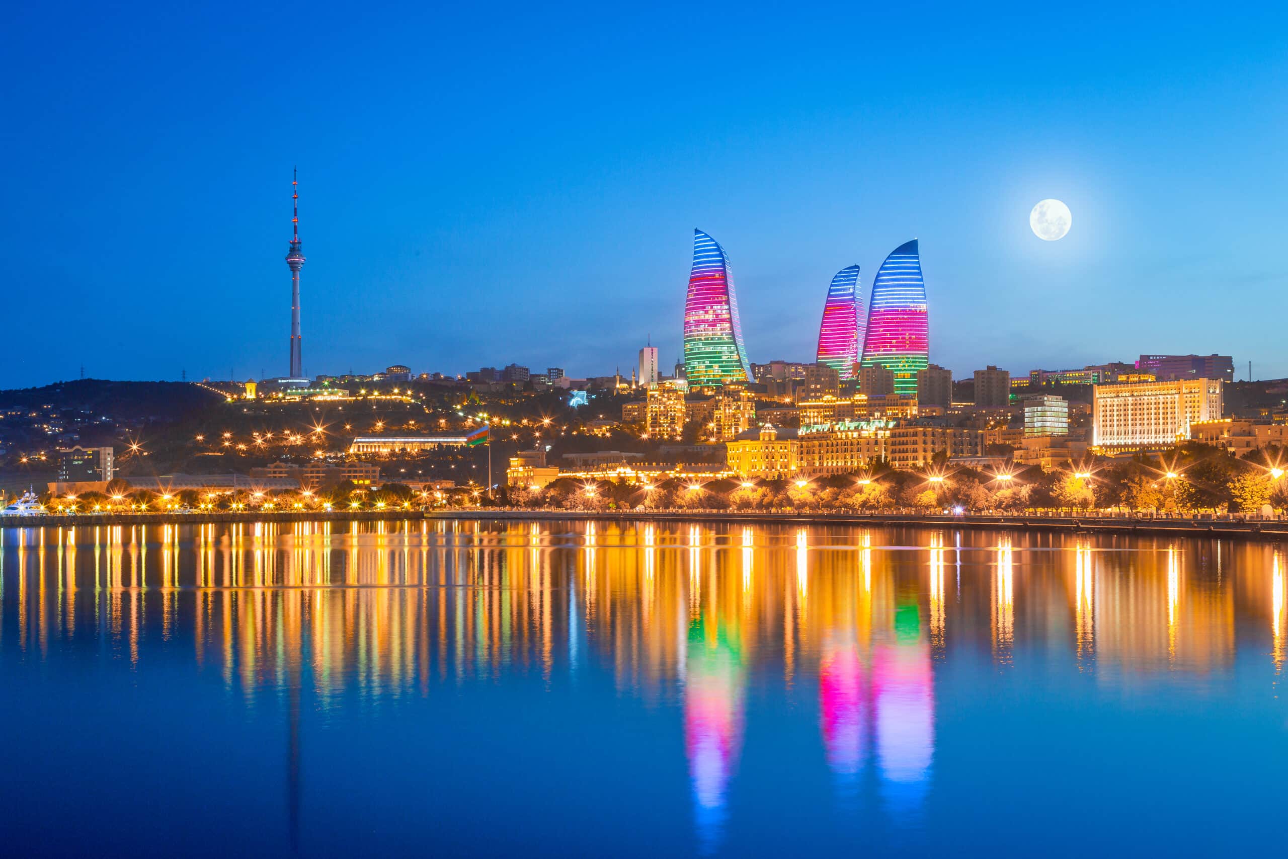
20. Baku
Baku lies on the Absheron Peninsula along the western coast of the Caspian Sea. Geography here is semi-arid coastal plateau characterized by low rainfall, strong winds, and saline soil conditions.
The Caspian Sea moderates temperature extremes. Geography reinforces maritime influence despite the region’s dry climate.
Flat steppe terrain surrounds the urban core. Geography binds development to exposed plains shaped by wind erosion.
The Absheron Peninsula contains mud volcanoes and natural gas vents. Geography emphasizes tectonic activity beneath sedimentary layers.
Coastal inlets form sheltered bays along the shoreline. Geography requires adaptation to fluctuating Caspian water levels.
Baku inspires through expansive sea views contrasting with arid inland horizons. The land teaches endurance through adaptation to dry winds and seismic terrain, showing how resilience develops where inland maritime geography meets semi-desert ecology.
Endurance here is climatic and geological. Geography requires coastal stabilization and careful management of groundwater resources. Stability depends on protecting shoreline ecosystems from erosion and salinity shifts.
Baku reflects Azerbaijan’s eastern coastal geography shaped by Caspian dynamics and tectonic forces. Visitors encounter a landscape where resilience emerges from coexistence between wind-swept peninsula and inland sea waters.
19. Sheki
Sheki lies in northwestern Azerbaijan at the southern foothills of the Greater Caucasus Mountains. Geography here is transitional between alpine slopes and fertile lowland plains.
Forested hills rise sharply behind the city. Geography reinforces protection from northern winds descending from high Caucasus ridges.
Seasonal rivers flow southward toward the Kura basin. Geography binds settlement to freshwater sources and alluvial soils.
The climate is more temperate than the Absheron Peninsula. Geography requires adaptation to cooler winters and moderate rainfall.
Mountain passes connect the region to neighboring valleys. Geography emphasizes natural corridors shaped by tectonic uplift.
Sheki inspires through layered mountain backdrops overlooking green foothill landscapes. The land teaches endurance through adaptation to altitude gradients and seasonal climate shifts, showing how resilience develops where alpine terrain meets agricultural lowlands.
Endurance here is climatic and hydrological. Geography requires slope stabilization and forest preservation to protect watersheds. Stability depends on maintaining balanced runoff from mountain streams feeding lower basins.
Sheki reflects Azerbaijan’s northern foothill geography shaped by Caucasus uplift and river erosion. Visitors encounter a landscape where resilience emerges from coexistence between forested slopes and fertile valley floors.
18. Ganja
Ganja lies in western Azerbaijan within the Kura–Aras Lowland near the foothills of the Lesser Caucasus. Geography here is broad plain framed by distant mountain ridges.
The Ganjachay River flows through the city toward the Kura basin. Geography reinforces agricultural productivity supported by irrigation.
Steppe terrain surrounds the urban area. Geography binds settlement to fertile soils shaped by river deposition.
The climate is semi-arid with hot summers and cool winters. Geography requires adaptation to limited rainfall and seasonal drought.
Nearby uplands moderate local winds. Geography emphasizes the transition from mountain foothill to open lowland basin.
Ganja inspires through expansive plains set against distant mountain silhouettes. The land teaches endurance through adaptation to semi-arid climate and irrigation-based agriculture, showing how resilience develops where foothill streams sustain steppe environments.
Endurance here is agricultural and climatic. Geography requires water management systems and soil conservation. Stability depends on protecting upstream watersheds feeding the Ganjachay River.
Ganja reflects Azerbaijan’s western lowland geography shaped by river systems and steppe ecology. Visitors encounter a landscape where resilience emerges from coexistence between fertile plains and rising Lesser Caucasus slopes.
17. Quba
Quba lies in northeastern Azerbaijan at the foothills of the Greater Caucasus near the Qudyal River. Geography here is mountainous transition zone between alpine ridges and rolling uplands.
The Qudyal River descends rapidly from higher elevations. Geography reinforces fertile valleys carved by fluvial erosion.
Forested slopes surround the city. Geography binds biodiversity to cooler mountain air and increased precipitation.
The climate is milder than central lowlands. Geography requires adaptation to seasonal rainfall and hillside runoff.
Roads follow river valleys toward mountain passes. Geography emphasizes natural corridors shaped by tectonic uplift.
Quba inspires through green valleys framed by rugged peaks. The land teaches endurance through adaptation to elevation gradients and river-carved terrain, showing how resilience develops where mountain waters sustain foothill agriculture.
Endurance here is hydrological and ecological. Geography requires forest conservation and erosion control on sloped land. Stability depends on preserving headwater streams feeding the Qudyal basin.
Quba reflects Azerbaijan’s northeastern foothill geography shaped by Caucasus uplift and river incision. Visitors encounter a landscape where resilience emerges from coexistence between alpine ridges and cultivated valleys.
16. Lankaran
Lankaran lies in southeastern Azerbaijan along the Caspian Sea near the border with Iran. Geography here is humid subtropical lowland backed by the Talysh Mountains.
The Lankaran Lowland stretches between mountain slopes and coastline. Geography reinforces fertile soils enriched by river sediments.
Rivers descend from the Talysh range into the Caspian basin. Geography binds agriculture to reliable freshwater and high rainfall compared to northern regions.
The climate is warmer and wetter than most of Azerbaijan. Geography requires adaptation to humidity and seasonal flooding.
Dense vegetation thrives along foothill zones. Geography emphasizes biodiversity supported by subtropical conditions.
Lankaran inspires through lush green plains framed by misty mountain ridges. The land teaches endurance through adaptation to humid climate and coastal proximity, showing how resilience develops where subtropical ecosystems meet inland sea shores.
Endurance here is climatic and hydrological. Geography requires watershed protection and coastal stabilization. Stability depends on maintaining forest cover in the Talysh Mountains to regulate runoff into lowland plains.
Lankaran reflects Azerbaijan’s southern maritime geography shaped by Caspian influence and mountain rainfall patterns. Visitors encounter a landscape where resilience emerges from coexistence between fertile coastal plains and forested uplands.
15. Gobustan
Gobustan National Park lies southwest of Baku on the semi-arid Absheron Plateau. Geography here is dry steppe and rocky outcrop shaped by wind erosion and tectonic movement.
Low limestone hills rise above flat plains. Geography reinforces exposure to strong Caspian winds.
Mud volcanoes dot the surrounding landscape. Geography binds subterranean gas pressure to surface geological formations.
Rainfall is limited and vegetation sparse. Geography requires adaptation to arid conditions and saline soils.
Seasonal streams carve shallow channels after rare rains. Geography emphasizes erosion shaped by episodic water flow.
Gobustan inspires through stark open horizons and textured rock formations. The land teaches endurance through adaptation to dryness and seismic forces, showing how resilience develops where sedimentary layers shift above active geological faults.
Endurance here is geological and climatic. Geography requires protection of fragile rock formations and management of erosion. Stability depends on preserving natural drainage patterns across the plateau.
Gobustan reflects Azerbaijan’s arid eastern geography shaped by tectonic uplift and inland sea winds. Visitors encounter a landscape where resilience emerges from coexistence between wind-swept plains and volatile mud volcano fields.
14. Nakhchivan
Nakhchivan lies in southwestern Azerbaijan as an exclave bordered by Armenia, Iran, and Turkey. Geography here is mountainous basin surrounded by the Zangezur range and arid uplands.
The Aras River flows along the southern boundary. Geography reinforces agricultural use of irrigated valley floors.
Rocky mountains dominate the skyline. Geography binds settlement to narrow fertile corridors between steep ridges.
The climate is continental and dry with hot summers and cold winters. Geography requires adaptation to limited rainfall and temperature extremes.
Mineral springs emerge from tectonic fault lines. Geography emphasizes active geological processes beneath the basin.
Nakhchivan inspires through rugged mountain silhouettes and expansive valley views. The land teaches endurance through adaptation to arid highland climate and seismic terrain, showing how resilience develops where enclosed basins rely on river-fed irrigation.
Endurance here is climatic and geological. Geography requires careful water management and slope conservation. Stability depends on preserving watershed integrity in surrounding mountain ranges.
Nakhchivan reflects Azerbaijan’s southwestern highland geography shaped by tectonic uplift and river incision. Visitors encounter a landscape where resilience emerges from coexistence between enclosed valleys and surrounding mountain barriers.
13. Gabala
Gabala lies in north-central Azerbaijan at the southern foothills of the Greater Caucasus Mountains. Geography here is transitional highland where alpine ridges descend into forested valleys and open plains.
Mountain slopes rise sharply north of the city. Geography reinforces elevation-driven climate moderation and increased precipitation compared to eastern lowlands.
The Damiraparan and Tikanli rivers flow through the region. Geography binds agricultural land to freshwater corridors fed by mountain runoff.
Forests cover the foothills. Geography requires protection of watershed areas vulnerable to erosion during heavy rains.
Higher elevations receive winter snowfall. Geography emphasizes seasonal contrasts shaped by altitude.
Gabala inspires through green valleys framed by distant snow-capped peaks. The land teaches endurance through adaptation to mountain climate and hydrological cycles, showing how resilience develops where Caucasus uplands nourish fertile lower basins.
Endurance here is climatic and ecological. Geography requires forest conservation and river management. Stability depends on safeguarding headwater streams that feed the broader Kura basin.
Gabala reflects Azerbaijan’s northern foothill geography shaped by tectonic uplift and fluvial erosion. Visitors encounter a landscape where resilience emerges from coexistence between alpine slopes and cultivated valley floors.
12. Mingachevir
Mingachevir lies in central Azerbaijan along the Kura River within the broad Kura–Aras Lowland. Geography here is flat steppe plain shaped by river deposition and semi-arid climate.
The Kura widens significantly in this region. Geography reinforces formation of reservoir basins and irrigated agricultural land.
Open plains stretch across the surrounding landscape. Geography binds settlement to water availability in otherwise dry terrain.
Rainfall is limited and summers are hot. Geography requires adaptation through irrigation and water storage systems.
Low hills appear distantly toward the west. Geography emphasizes the expansive nature of central lowlands.
Mingachevir inspires through broad water surfaces contrasting with surrounding steppe horizons. The land teaches endurance through adaptation to arid climate and river management, showing how resilience develops where large river systems sustain dry plains.
Endurance here is hydrological and climatic. Geography requires careful regulation of water flow and soil conservation to prevent salinization. Stability depends on maintaining upstream watershed balance within the Kura basin.
Mingachevir reflects Azerbaijan’s central lowland geography shaped by river systems and semi-desert ecology. Visitors encounter a landscape where resilience emerges from coexistence between major waterways and wide steppe plains.
11. Khinalug
Khinalug lies high in the Greater Caucasus Mountains of northeastern Azerbaijan at an elevation exceeding 2,000 meters. Geography here is extreme alpine terrain characterized by steep slopes and rocky ridgelines.
The village sits on a mountain plateau overlooking deep valleys. Geography reinforces natural isolation shaped by altitude and rugged relief.
Snow covers the region for much of the year. Geography binds habitation to short growing seasons and limited arable land.
Mountain streams descend toward the Qudyal River basin. Geography requires protection of fragile alpine watersheds.
Access roads wind through narrow passes. Geography emphasizes remoteness created by tectonic uplift.
Khinalug inspires through panoramic mountain vistas and expansive skies. The land teaches endurance through adaptation to high elevation and harsh winters, showing how resilience develops where communities inhabit exposed alpine plateaus.
Endurance here is climatic and geological. Geography requires slope stabilization and preservation of high-altitude grasslands. Stability depends on maintaining vegetation cover that protects against erosion during snowmelt.
Khinalug reflects Azerbaijan’s northeastern alpine geography shaped by Caucasus mountain building and erosion. Visitors encounter a landscape where resilience emerges from coexistence between high mountain ridges and isolated plateau settlements.
10. Shamakhi
Shamakhi lies in central Azerbaijan on the southeastern slopes of the Greater Caucasus Mountains. Geography here is transitional upland marked by rolling hills, seismic fault lines, and semi-arid valleys.
Elevations rise gradually toward forested ridges. Geography reinforces climatic variation between cooler uplands and warmer lowlands.
Seasonal rivers descend toward the Kura basin. Geography binds agriculture to irrigation supported by mountain runoff.
The region sits within an active seismic zone. Geography requires adaptation to tectonic instability and careful structural planning.
Open steppe alternates with patches of woodland. Geography emphasizes contrast between dry plains and elevated relief.
Shamakhi inspires through expansive upland views framed by distant Caucasus peaks. The land teaches endurance through adaptation to seismic terrain and variable rainfall, showing how resilience develops where tectonic forces shape rolling highland corridors.
Endurance here is geological and climatic. Geography requires slope stabilization and protection of upstream watersheds. Stability depends on preserving vegetation that prevents erosion during seasonal rains.
Shamakhi reflects Azerbaijan’s central upland geography shaped by mountain uplift and fault activity. Visitors encounter a landscape where resilience emerges from coexistence between seismic hills and cultivated valleys.
9. Astara
Astara lies at Azerbaijan’s southernmost point along the Caspian Sea near the border with Iran. Geography here is humid coastal plain backed by the Talysh Mountains.
The Astara River forms part of the international boundary. Geography reinforces settlement along fertile riverbanks and coastal strips.
The Talysh Mountains rise steeply inland. Geography binds dense forests to increased rainfall compared to northern regions.
The climate is subtropical with high humidity. Geography requires adaptation to heavy precipitation and occasional flooding.
Low-lying wetlands appear along the shoreline. Geography emphasizes ecological interaction between mountain runoff and Caspian waters.
Astara inspires through lush greenery contrasting with open sea horizons. The land teaches endurance through adaptation to moisture-rich climate and coastal exposure, showing how resilience develops where forested slopes descend into maritime plains.
Endurance here is climatic and hydrological. Geography requires watershed protection and shoreline management. Stability depends on preserving mountain forests that regulate water flow into lowlands.
Astara reflects Azerbaijan’s southern maritime geography shaped by Caspian influence and mountain rainfall patterns. Visitors encounter a landscape where resilience emerges from coexistence between subtropical foothills and inland sea coastline.
8. Lahij
Lahij lies in the Ismayilli district within the southern slopes of the Greater Caucasus. Geography here is mountainous terrain characterized by deep gorges and forested ridges.
The Girdimanchay River cuts through a narrow valley below the settlement. Geography reinforces natural defense created by steep canyon walls.
Elevated slopes surround the village. Geography binds habitation to terraces carved into rugged hillsides.
The climate is cooler than nearby lowlands. Geography requires adaptation to seasonal snow and limited agricultural space.
Access roads follow winding mountain corridors. Geography emphasizes isolation shaped by tectonic uplift.
Lahij inspires through dramatic canyon scenery and panoramic upland views. The land teaches endurance through adaptation to seismic terrain and climatic variation, showing how resilience develops where mountain valleys sustain small communities.
Endurance here is geological and hydrological. Geography requires erosion control and forest preservation on steep slopes. Stability depends on maintaining vegetation that protects the Girdimanchay watershed.
Lahij reflects Azerbaijan’s northeastern upland geography shaped by Caucasus mountain processes and river incision. Visitors encounter a landscape where resilience emerges from coexistence between narrow mountain valleys and surrounding forested ridges.
7. Naftalan
Naftalan lies in western Azerbaijan within the Goranboy district on the edge of the Kura–Aras Lowland. Geography here is semi-arid plain transitioning toward the foothills of the Lesser Caucasus.
Flat steppe terrain surrounds the settlement. Geography reinforces exposure to hot summers and limited annual rainfall.
Seasonal streams flow toward the Kura basin. Geography binds agriculture to irrigation systems sustained by regional waterways.
Low hills appear to the west. Geography emphasizes gradual elevation change between plain and upland zones.
The climate is continental with pronounced seasonal variation. Geography requires adaptation to drought conditions and soil management challenges.
Naftalan inspires through wide horizons and open skies characteristic of Azerbaijan’s western plains. The land teaches endurance through adaptation to dry climate and steppe ecology, showing how resilience develops where limited water resources must sustain settlement.
Endurance here is climatic and hydrological. Geography requires careful groundwater regulation and soil conservation to prevent salinity. Stability depends on protecting upstream river systems feeding irrigation networks.
Naftalan reflects Azerbaijan’s central-western lowland geography shaped by river deposition and semi-desert conditions. Visitors encounter a landscape where resilience emerges from coexistence between steppe plains and distant mountain silhouettes.
6. Ordubad
Ordubad lies in the Nakhchivan Autonomous Republic near the border with Iran, nestled at the foothills of the Zangezur Mountains. Geography here is enclosed mountain valley shaped by tectonic uplift and river erosion.
The Ordubadchay River flows through the settlement. Geography reinforces agriculture supported by mountain-fed irrigation.
Steep ridges surround the valley. Geography binds habitation to narrow fertile corridors carved between rocky slopes.
The climate is dry continental with hot summers and cold winters. Geography requires adaptation to limited rainfall and snowmelt cycles.
Terraced slopes appear along valley edges. Geography emphasizes efficient land use in constrained mountain terrain.
Ordubad inspires through rugged mountain backdrops and compact valley landscapes. The land teaches endurance through adaptation to arid highland conditions and seismic terrain, showing how resilience develops where enclosed basins depend on carefully managed water resources.
Endurance here is climatic and geological. Geography requires slope stabilization and watershed preservation in surrounding mountains. Stability depends on maintaining snowmelt-fed streams that sustain valley agriculture.
Ordubad reflects Azerbaijan’s southwestern highland geography shaped by mountain building and river incision. Visitors encounter a landscape where resilience emerges from coexistence between steep ridges and irrigated valley floors.
5. Zagatala
Zagatala lies in northwestern Azerbaijan near the border with Georgia at the southern foothills of the Greater Caucasus. Geography here is fertile foothill basin framed by forested mountains.
Rivers descend from high Caucasus peaks into the Alazani basin. Geography reinforces rich alluvial soils and reliable freshwater supply.
Dense forests blanket the surrounding slopes. Geography binds biodiversity to cooler mountain climate and increased precipitation.
The region receives more rainfall than central lowlands. Geography requires management of hillside runoff and erosion.
Mountain passes connect valleys across the border. Geography emphasizes natural corridors shaped by tectonic uplift.
Zagatala inspires through green landscapes set against dramatic Caucasus ridgelines. The land teaches endurance through adaptation to elevation gradients and seasonal climate shifts, showing how resilience develops where alpine waters nourish foothill plains.
Endurance here is ecological and hydrological. Geography requires forest conservation and careful watershed protection. Stability depends on maintaining mountain vegetation that regulates river flow into lowland basins.
Zagatala reflects Azerbaijan’s northwestern foothill geography shaped by Caucasus uplift and fluvial processes. Visitors encounter a landscape where resilience emerges from coexistence between forested slopes and fertile valleys.
4. Bilgah
Bilgah lies on the northeastern coast of the Absheron Peninsula along the Caspian Sea. Geography here is low-lying semi-arid shoreline shaped by wind erosion and shifting coastal sediments.
Flat sandy terrain stretches inland from the water. Geography reinforces exposure to strong Caspian winds and saline soils.
The peninsula’s arid climate limits natural vegetation. Geography binds settlement to managed water resources and coastal wells.
Shallow coastal waters extend gradually offshore. Geography requires adaptation to fluctuating Caspian sea levels.
Inland steppe dominates beyond the narrow coastal strip. Geography emphasizes the fragile balance between dry plains and marine influence.
Bilgah inspires through open sea horizons contrasting with wind-swept inland flats. The land teaches endurance through adaptation to dry climate and coastal exposure, showing how resilience develops where inland sea dynamics shape sandy shorelines.
Endurance here is climatic and coastal. Geography requires shoreline stabilization and protection of dune systems from erosion. Stability depends on maintaining natural sediment flow and regulating groundwater extraction in semi-arid terrain.
Bilgah reflects Azerbaijan’s eastern maritime geography shaped by Caspian winds and steppe ecology. Visitors encounter a landscape where resilience emerges from coexistence between exposed peninsula and inland sea waters.
3. Ismayilli
Ismayilli lies in north-central Azerbaijan on the southern slopes of the Greater Caucasus. Geography here is mountainous foothill terrain characterized by forested ridges and deep valleys.
Elevations rise steadily toward alpine peaks. Geography reinforces climatic moderation compared to arid eastern lowlands.
Rivers descend through narrow gorges toward the Kura basin. Geography binds settlement to fertile valley floors sustained by mountain runoff.
Mixed forests blanket higher slopes. Geography requires protection of biodiversity and erosion control on steep gradients.
Seasonal snowfall occurs in upland zones. Geography emphasizes altitude-driven weather variation.
Ismayilli inspires through green hills framed by distant Caucasus summits. The land teaches endurance through adaptation to mountainous terrain and hydrological cycles, showing how resilience develops where upland waters sustain lower agricultural plains.
Endurance here is ecological and hydrological. Geography requires forest conservation and watershed management. Stability depends on maintaining vegetation cover that regulates stream flow into broader river systems.
Ismayilli reflects Azerbaijan’s northern foothill geography shaped by tectonic uplift and river erosion. Visitors encounter a landscape where resilience emerges from coexistence between forested highlands and cultivated valleys.
2. Masalli
Masalli lies in southeastern Azerbaijan between the Talysh Mountains and the Caspian Sea. Geography here is humid lowland transitioning toward densely forested foothills.
The Vilash River flows through the region toward the Caspian. Geography reinforces fertile soils and abundant freshwater supply.
The Talysh range rises to the west. Geography binds heavy rainfall to mountain slopes and subtropical vegetation growth.
The climate is warm and humid. Geography requires adaptation to periodic flooding and soil drainage management.
Low coastal plains extend eastward. Geography emphasizes the meeting of mountain runoff and inland sea shoreline.
Masalli inspires through lush landscapes backed by green mountain ridges. The land teaches endurance through adaptation to humid subtropical climate and hydrological abundance, showing how resilience develops where forested slopes descend into fertile coastal plains.
Endurance here is climatic and ecological. Geography requires preservation of mountain forests and regulation of river systems. Stability depends on maintaining watershed balance between uplands and lowlands.
Masalli reflects Azerbaijan’s southern maritime geography shaped by Caspian influence and Talysh mountain rainfall. Visitors encounter a landscape where resilience emerges from coexistence between humid foothills and expansive coastal plains.
1. Yanar Dag
Yanar Dag lies on the Absheron Peninsula north of Baku, where natural gas seeps ignite along a low sandstone hillside. Geography here is semi-arid steppe shaped by sedimentary basins rich in hydrocarbons.
The hillside burns continuously due to underground gas emissions. Geography reinforces the presence of tectonic fractures allowing natural gas to reach the surface.
Dry terrain surrounds the site. Geography binds sparse vegetation to saline soils and limited rainfall.
Strong Caspian winds influence flame movement. Geography requires adaptation to exposed plateau conditions.
The Absheron Peninsula contains numerous mud volcanoes and gas vents. Geography emphasizes active geological processes beneath seemingly flat landscapes.
Yanar Dag inspires through the striking image of flames rising from bare earth against open sky. The land teaches endurance through adaptation to tectonic forces and arid climate, showing how resilience develops where subterranean energy interacts with surface terrain.
Endurance here is geological and climatic. Geography requires protection of fragile sedimentary structures and careful management of surrounding steppe ecosystems. Stability depends on monitoring gas emissions linked to regional fault systems.
Yanar Dag reflects Azerbaijan’s eastern peninsula geography shaped by hydrocarbon deposits, tectonic uplift, and Caspian environmental influence. Visitors encounter a landscape where resilience emerges from coexistence between dry steppe plains and persistent natural fire.