
Afghanistan is a country defined by elevation. Mountain systems dominate its structure, dividing terrain into high plateaus, narrow valleys, and desert basins. Geography here is not background but framework. The Hindu Kush cuts diagonally across the nation, shaping climate, settlement, and movement.
Rivers descend from glaciated peaks into arid plains, sustaining life in corridors carved by time. Geography fragments and connects simultaneously. Passes open briefly between ranges, while valleys shelter agriculture within otherwise severe terrain. The land determines rhythm—winter isolation, summer mobility.
Afghanistan’s position at the crossroads of Central and South Asia has long reinforced its geographic significance. Routes through mountain passes once carried caravans, scholars, and empires. Geography dictated exchange, but also defense. High ridges offered protection; narrow corridors required resilience.
The landscape inspires through scale and endurance. The land teaches persistence where altitude, climate, and distance impose discipline. Settlements rise where water permits, and architecture reflects adaptation to heat, cold, and wind.
Endurance here is environmental before it is historical. Geography shapes experience through exposure and contrast—snowfields above, deserts below, fertile valleys suspended between extremes.
Afghanistan reflects a country where resilience emerges from terrain itself. Visitors encounter a landscape that reinforces survival through adaptation, shaped by mountains that demand patience and valleys that reward careful alignment with water and season.
18. Bamyan Valley
Bamyan Valley rests high within central Afghanistan, enclosed by branches of the Hindu Kush. Geography here is protective and expansive at once. The valley floor stretches wide beneath towering sandstone cliffs carved by centuries of erosion.
Snowmelt from surrounding peaks feeds agricultural fields along the valley basin. Geography sustains cultivation through controlled water flow, allowing settlement within otherwise mountainous terrain. The cliffs form a natural wall that frames sky and land in balanced proportion.
Movement through Bamyan follows open plains rather than narrow corridors. Geography provides relative breadth compared to steeper valleys elsewhere in the country. Elevation moderates temperature, creating seasonal cycles distinct from lowland deserts.
Bamyan inspires through openness within enclosure. The land teaches endurance through continuity, showing how resilience can flourish where geography offers both protection and space. The valley holds memory within stone and soil alike.
Endurance here is agricultural and climatic. Geography enables cultivation at altitude while requiring adaptation to long winters. Strength emerges from alignment with seasonal rhythm.
Bamyan reflects an Afghanistan shaped by mountain shelter and highland fertility. Visitors encounter a landscape that reinforces resilience as coexistence between cliff and field, elevation and sustenance.
17. Band-e-Amir National Park
Band-e-Amir lies west of Bamyan, where a chain of deep blue lakes fills travertine basins formed by mineral deposits. Geography here is rare and precise. Natural dams of limestone separate each lake, creating distinct terraces of water across a high plateau.
Snow-fed streams feed the basins slowly, depositing minerals that strengthen the dams over time. Geography demonstrates accumulation rather than erosion—water building structure instead of removing it. The lakes sit at altitude, surrounded by barren hills that emphasize their color and clarity.
Movement between the lakes follows gentle rises and natural viewpoints. Geography shapes visibility; each basin reveals itself sequentially, reinforcing the sense of progression through landscape.
Band-e-Amir inspires through contrast. The land teaches endurance through formation, showing how resilience can arise from gradual deposition. In a country marked by rugged mountains, these lakes represent delicate equilibrium sustained by time and chemistry.
Endurance here is geological and hydrological. Geography binds water and stone into stable relationship, maintained through steady mineral flow and seasonal melt.
Band-e-Amir reflects an Afghanistan where resilience forms through patience. Visitors encounter a landscape that reinforces endurance as accumulation—structure built quietly across centuries within a high and austere environment.
16. Panjshir Valley
Panjshir Valley cuts sharply through the Hindu Kush northeast of Kabul. Geography here is narrow and forceful. The Panjshir River descends rapidly between steep rock walls, carving a corridor that stretches deep into mountainous interior.
Snow and glacier melt from surrounding peaks sustain the river year-round. Geography dictates settlement along its banks, where fertile strips of land support orchards and small villages. Beyond these margins, slopes rise abruptly into stone and scree.
Movement through Panjshir follows the river’s course. The valley functions as passage through otherwise impenetrable terrain. Geography compresses life into linear form, concentrating agriculture, transport, and habitation along a single axis.
The valley inspires through determination. The land teaches endurance through constraint, showing how resilience develops where geography offers little lateral expansion. Strength arises from adaptation to narrow opportunity.
Endurance here is hydrological and communal. Geography binds community to river, requiring careful management of water and terrain. Winter snow isolates upper sections, reinforcing reliance on seasonal planning.
Panjshir reflects an Afghanistan where geography shapes resilience through corridor and containment. Visitors encounter a landscape that reinforces endurance as focus—life sustained along a river that threads through mountain mass with persistent force.
15. Wakhan Corridor
The Wakhan Corridor stretches as a narrow arm of territory in northeastern Afghanistan, wedged between Tajikistan, Pakistan, and China. Geography here is elongated and elevated. The corridor extends for hundreds of kilometers, rising steadily into the high Pamir plateau where altitude defines climate and movement.
Mountain chains flank the corridor on both sides. The Pamir and Hindu Kush systems converge, creating a landscape of snow peaks, glacial rivers, and broad alpine plains. Geography enforces remoteness. Settlements remain sparse, and distances between them are considerable.
Rivers fed by glaciers shape the valley floor, providing narrow strips of arable land within a predominantly rugged environment. Geography determines survival through water access and seasonal migration. Pastoralism remains aligned with altitude and grass availability.
Movement through the Wakhan follows natural river corridors and high passes. Geography permits passage, yet only gradually. Winter snow closes routes; summer opens them. Access depends entirely on season.
The corridor inspires through isolation and scale. The land teaches endurance through patience, showing how resilience develops where geography limits density and rewards mobility. Life adapts to thin air and extreme climate through repetition rather than expansion.
Endurance here is environmental and spatial. Geography stretches perception, reinforcing awareness of distance and elevation as defining forces. Human presence feels integrated rather than imposed.
The Wakhan Corridor reflects an Afghanistan where resilience emerges from coexistence with high-altitude vastness. Visitors encounter a landscape that reinforces endurance as sustained movement through remote terrain shaped by mountain systems that converge without softening.
14. Minaret of Jam
The Minaret of Jam stands within a remote valley in central-western Afghanistan, rising unexpectedly above rugged hills along the Hari River. Geography here is concealed and dramatic. The monument occupies a narrow corridor shaped by steep slopes and river erosion.
Built of fired brick and decorated with intricate calligraphy, the minaret rises more than sixty meters from a gravel plain. Geography isolates the structure, protecting it through inaccessibility. Surrounding terrain remains largely undeveloped, reinforcing its solitary presence.
The valley floor is shaped by seasonal flooding. Geography binds monument and river in shared vulnerability. Erosion continues slowly, reminding that preservation depends on balance between water flow and structural stability.
Movement toward Jam requires passage along winding dirt tracks and mountain roads. Geography discourages casual visitation, reinforcing awareness of remoteness.
The site inspires through vertical emphasis within horizontal landscape. The land teaches endurance through placement, showing how resilience can be expressed architecturally within challenging terrain. The minaret rises not in urban density but in rural isolation.
Endurance here is structural and environmental. Geography tests durability through climate and river proximity. Survival depends on foundation and maintenance against natural forces.
The Minaret of Jam reflects an Afghanistan where geography frames cultural resilience. Visitors encounter a landscape that reinforces endurance as continuity between human construction and mountain valley environment.
13. Herat
Herat lies in western Afghanistan near the Iranian border, positioned within a fertile plain sustained by the Hari River. Geography here is transitional. The surrounding landscape shifts from semi-arid plateau to cultivated fields nourished by irrigation.
Unlike the high mountain regions of central Afghanistan, Herat occupies lower elevation with broader agricultural potential. Geography supports settlement through water management and trade access. Historic routes connecting Persia and Central Asia converged here due to relatively navigable terrain.
The city’s built environment reflects adaptation to climate. Thick walls and courtyards moderate heat, while open plains allow expansion beyond fortified cores. Geography encourages outward orientation rather than confinement within steep valleys.
Movement through Herat follows flat corridors shaped by river flow and historic caravan routes. Geography permits connectivity across distance more readily than mountainous provinces.
Herat inspires through continuity across landscape and culture. The land teaches endurance through openness, showing how resilience can grow where geography allows exchange instead of isolation. Fertile plains sustain agriculture while trade routes sustain interaction.
Endurance here is agricultural and regional. Geography binds city and countryside in functional partnership, reinforcing stability through irrigation and accessible terrain.
Herat reflects an Afghanistan where resilience is shaped by plains rather than peaks. Visitors encounter a landscape that reinforces endurance as sustained cultivation within open, river-fed environment.
12. Nuristan
Nuristan occupies a remote region in eastern Afghanistan where steep valleys descend from the southern Hindu Kush. Geography here is abrupt and forested. Unlike much of the country’s arid terrain, Nuristan supports dense woodland across sharp inclines shaped by heavy precipitation and snowmelt.
Rivers cut deeply through rock, creating narrow valleys that isolate communities from one another. Geography fragments settlement into distinct pockets separated by ridges and fast-moving water. Access remains difficult, often limited to winding mountain tracks.
Elevation changes rapidly within short distances. Geography dictates agricultural practice through terraced slopes and seasonal migration between valley floor and upland pasture. Timber and water define the region’s material structure.
Nuristan inspires through vertical intensity. The land teaches endurance through adaptation to steepness, showing how resilience can form where geography offers little horizontal expansion. Architecture responds directly to slope and climate.
Endurance here is ecological and communal. Geography demands cooperation within confined valleys while reinforcing independence between them. Winter snow increases isolation, shaping seasonal rhythm.
Nuristan reflects an Afghanistan where resilience emerges from forested mountain terrain. Visitors encounter a landscape that reinforces endurance as alignment with steep, water-fed valleys shaped by altitude and containment.
11. Mazar-i-Sharif
Mazar-i-Sharif lies in northern Afghanistan near the plains that extend toward Central Asia. Geography here is broad and comparatively level. The city stands within an agricultural basin nourished by irrigation channels branching from regional rivers.
Unlike the rugged Hindu Kush interior, the northern plains offer greater horizontal continuity. Geography supports cultivation of wheat, cotton, and orchards across wide fields. Settlement expands outward rather than upward.
Movement through Mazar-i-Sharif follows open road networks shaped by flat terrain. Geography facilitates connectivity with neighboring regions, reinforcing its role as a northern hub.
The city inspires through openness. The land teaches endurance through cultivation and trade, showing how resilience develops where geography permits agricultural stability. Water management determines productivity in an otherwise semi-arid plain.
Endurance here is infrastructural and agricultural. Geography binds urban life to irrigation systems that sustain surrounding farmland. Seasonal cycles govern yield and livelihood.
Mazar-i-Sharif reflects an Afghanistan where resilience is shaped by plains rather than mountain enclosure. Visitors encounter a landscape that reinforces endurance as sustained cultivation within expansive northern terrain.
10. Kabul
Kabul rests within a high valley surrounded by mountain ridges of the eastern Hindu Kush. Geography here is enclosed yet central. The city occupies a basin through which the Kabul River flows, linking highlands to eastern corridors.
Mountains rise sharply around the urban core, defining skyline and limiting expansion. Geography shapes settlement density through confinement. Elevation moderates climate but reinforces winter cold and summer heat contrasts.
Historic routes converged in Kabul due to its position between passes leading toward Central Asia and the Indian subcontinent. Geography positioned the city as a crossroads while also sheltering it within surrounding hills.
Movement through Kabul reflects valley structure. Roads follow natural contours and river alignment. Geography continues to influence expansion, with development spreading along accessible corridors rather than steep slopes.
Kabul inspires through centrality within constraint. The land teaches endurance through balance, showing how resilience forms where geography both protects and restricts. Water, altitude, and access combine to define possibility.
Endurance here is urban and environmental. Geography requires adaptation to seasonal variation and limited space within mountain boundaries. Growth must negotiate terrain rather than override it.
Kabul reflects an Afghanistan where resilience arises from functioning within enclosed highland geography. Visitors encounter a landscape that reinforces endurance as coexistence between basin settlement and mountain perimeter.
9. Kandahar
Kandahar lies in southern Afghanistan within a broad arid plain shaped by desert margins and irrigated cultivation. Geography here is open and dry. The surrounding terrain consists of gravel flats, low hills, and agricultural fields sustained by underground water systems and seasonal rivers.
Unlike the mountain-enclosed cities of the north and east, Kandahar occupies horizontal space. Geography allows outward expansion across relatively level land. Irrigation channels and traditional karez systems draw groundwater toward orchards and vineyards, reinforcing settlement within an otherwise harsh environment.
Movement through Kandahar follows desert corridors that connect southern Afghanistan with routes toward Iran and Pakistan. Geography facilitates trade through plains rather than mountain passes. Distance defines travel more than elevation.
Kandahar inspires through persistence in aridity. The land teaches endurance through water management, showing how resilience develops where rainfall is scarce but underground systems sustain continuity. Agriculture depends entirely on careful allocation.
Endurance here is climatic and hydrological. Geography binds settlement to wells and channels that must be maintained over generations. Heat shapes architecture and daily rhythm.
Kandahar reflects an Afghanistan where resilience emerges from adaptation to desert-edge conditions. Visitors encounter a landscape that reinforces endurance as stewardship of water within expansive southern plains.
8. Balkh
Balkh stands near the northern plains close to the Amu Darya basin. Geography here is ancient and sedimentary. Fertile soils deposited by rivers have supported settlement for millennia within otherwise semi-arid surroundings.
The land stretches flat toward Central Asia, allowing agricultural continuity across distance. Geography encourages cultivation and connectivity rather than isolation. Irrigation transforms dry plains into productive farmland.
Movement through Balkh is shaped by openness. Roads and trade routes follow gentle terrain, reinforcing exchange with neighboring regions. Geography offers access without significant topographic barrier.
Balkh inspires through longevity rooted in landscape. The land teaches endurance through stability, showing how resilience develops where soil fertility and water access sustain continuous habitation. Settlement rests upon geological accumulation.
Endurance here is agricultural and historical. Geography supports permanence through fertile plains that buffer against extreme scarcity.
Balkh reflects an Afghanistan where resilience grows from river-fed sediment and open terrain. Visitors encounter a landscape that reinforces endurance as continuity across generations shaped by plain and river.
7. Salang Pass
Salang Pass cuts through the Hindu Kush north of Kabul, forming a high-altitude corridor that links central Afghanistan with northern plains. Geography here is steep and decisive. The pass rises above 3,000 meters, where snow and rock dominate much of the year.
Mountains flank the route closely. Slopes ascend sharply from the road, emphasizing the narrowness of passage. Geography compresses movement into a defined corridor, with little deviation possible. Winter snow frequently restricts travel.
A tunnel beneath the highest point reinforces the pass’s strategic importance. Geography demanded engineering adaptation to maintain connectivity between regions divided by the Hindu Kush.
Movement through Salang is vertical before horizontal. Travelers ascend through winding roads before descending into northern valleys. Geography enforces transition through elevation change rather than gradual slope.
The pass inspires through determination in high terrain. The land teaches endurance through ascent, showing how resilience forms where geography challenges continuity between regions. Connectivity depends on maintaining passage against climate and altitude.
Endurance here is infrastructural and environmental. Geography tests both road and traveler through snow accumulation, rockfall, and seasonal variability.
Salang Pass reflects an Afghanistan where resilience is defined by maintaining corridors through mountain mass. Visitors encounter a landscape that reinforces endurance as persistence across elevation and constraint within one of the country’s most significant highland routes.
6. Panjshir Valley
The Panjshir Valley extends northeast of Kabul, carved by the Panjshir River through the Hindu Kush. Geography here is linear and enclosed. Steep mountains rise sharply from the valley floor, forming a corridor defined by rock, water, and elevation.
The river sustains narrow agricultural strips along its banks. Geography concentrates cultivation within limited flat land, reinforcing settlement in compact clusters. Beyond irrigated zones, slopes ascend quickly into rugged highland terrain.
Movement through the valley follows the river’s course. Geography dictates direction, offering few alternative routes. Side valleys branch upward into alpine areas, but the main corridor remains the central axis of habitation and transit.
The valley inspires through alignment with terrain. The land teaches endurance through adaptation to enclosure, showing how resilience develops within confined mountain spaces shaped by water flow and seasonal change. Winter snow isolates upper sections, reinforcing rhythm through climate.
Endurance here is hydrological and structural. Geography binds life to river access while testing stability through rockfall and snowmelt. Architecture reflects slope and stone availability.
Panjshir Valley reflects an Afghanistan where resilience emerges from narrow highland corridors sustained by river systems. Visitors encounter a landscape that reinforces endurance as coexistence between water, rock, and altitude.
5. Band-e Amir
Band-e Amir consists of a chain of deep blue lakes in the central highlands of Bamyan Province. Geography here is elevated and mineral-formed. Natural travertine dams created by mineral deposits separate the lakes, shaping stepped basins within arid surroundings.
The lakes sit above 2,900 meters in altitude. Geography isolates them within broad plateau terrain framed by low mountains. Water color shifts with depth and light, reflecting mineral composition and clarity.
Movement around Band-e Amir follows plateau roads and footpaths. Geography allows horizontal travel across high elevation plains, contrasting with steeper nearby valleys. The lakes occupy natural depressions shaped over centuries.
The site inspires through contrast. The land teaches endurance through persistence of water in high-altitude dryness, showing how resilience can appear in unexpected forms within otherwise stark terrain. Mineral processes shape both structure and appearance.
Endurance here is geological and climatic. Geography sustains fragile balance between evaporation, inflow, and mineral formation. Seasonal variation affects accessibility and temperature.
Band-e Amir reflects an Afghanistan where resilience arises from geological patience. Visitors encounter a landscape that reinforces endurance as continuity between water, mineral, and plateau environment.
4. Khyber Pass
The Khyber Pass lies along Afghanistan’s eastern frontier, forming a mountain corridor linking Kabul’s basin to the plains of Pakistan. Geography here is transitional and strategic. The pass cuts through arid ridges, creating a narrow route between highland and lowland regions.
Rock formations rise steeply along the passage. Geography compresses movement into a defined channel shaped by erosion and tectonic uplift. The corridor gradually descends toward warmer, lower terrain.
Unlike high alpine passes, the Khyber’s elevation is moderate, yet its surrounding ridges remain imposing. Geography emphasizes directionality—movement flows along the pass rather than across it. Natural constraints define access between regions.
The pass inspires through connectivity shaped by terrain. The land teaches endurance through navigation of corridor geography, showing how resilience develops where mountains guide exchange rather than block it entirely. Climate shifts noticeably along the route.
Endurance here is geographic and transitional. Geography links ecological zones, reinforcing adaptation to changing altitude and temperature. Infrastructure follows natural contours rather than overriding them.
Khyber Pass reflects an Afghanistan where resilience is shaped by maintaining pathways through rugged frontier terrain. Visitors encounter a landscape that reinforces endurance as movement between distinct geographic worlds aligned along a mountain corridor.
3. Badakhshan
Badakhshan occupies Afghanistan’s far northeastern highlands, where the Hindu Kush merges with the Pamir system. Geography here is elevated and fragmented. Sharp ridgelines divide deep valleys fed by glacial meltwater descending toward the Amu Darya basin.
The terrain rises abruptly from cultivated valley floors into snow-covered peaks. Geography restricts settlement to narrow river corridors, reinforcing agricultural dependence on seasonal water flow. Beyond irrigated margins, slopes remain rocky and sparsely vegetated.
Movement through Badakhshan follows valley channels and high passes. Geography enforces gradual ascent and descent between isolated districts. Winter snow frequently closes routes, strengthening reliance on seasonal planning.
The province inspires through remoteness shaped by altitude. The land teaches endurance through adaptation to fragmented terrain, showing how resilience forms where geography divides yet sustains through water networks.
Endurance here is glacial and communal. Geography ties life to meltwater cycles and limited arable land. Communities persist through alignment with seasonal rhythm rather than expansion.
Badakhshan reflects an Afghanistan where resilience emerges from high mountain fragmentation. Visitors encounter a landscape that reinforces endurance as coexistence with glacier-fed systems and enclosed valley spaces.
2. Dasht-e Margo
Dasht-e Margo stretches across southwestern Afghanistan as an expanse of desert plateau and gravel plain. Geography here is stark and horizontal. Sparse vegetation dots wide terrain shaped by wind erosion and limited rainfall.
The name translates to “Desert of Death,” reflecting harsh environmental conditions rather than constant inhabitation. Geography limits permanent settlement, confining life to oases and seasonal grazing zones.
Movement across Dasht-e Margo emphasizes distance rather than elevation. The horizon remains uninterrupted for long stretches, reinforcing scale through openness. Water sources remain scattered and critical.
The desert inspires through austerity. The land teaches endurance through restraint, showing how resilience develops where geography offers minimal abundance. Survival depends on mobility and knowledge of terrain.
Endurance here is climatic and spatial. Geography enforces adaptation to heat, aridity, and limited water access. Wind reshapes surface subtly but persistently.
Dasht-e Margo reflects an Afghanistan where resilience forms at desert margins. Visitors encounter a landscape that reinforces endurance as navigation across wide, uncompromising terrain shaped by dryness and exposure.
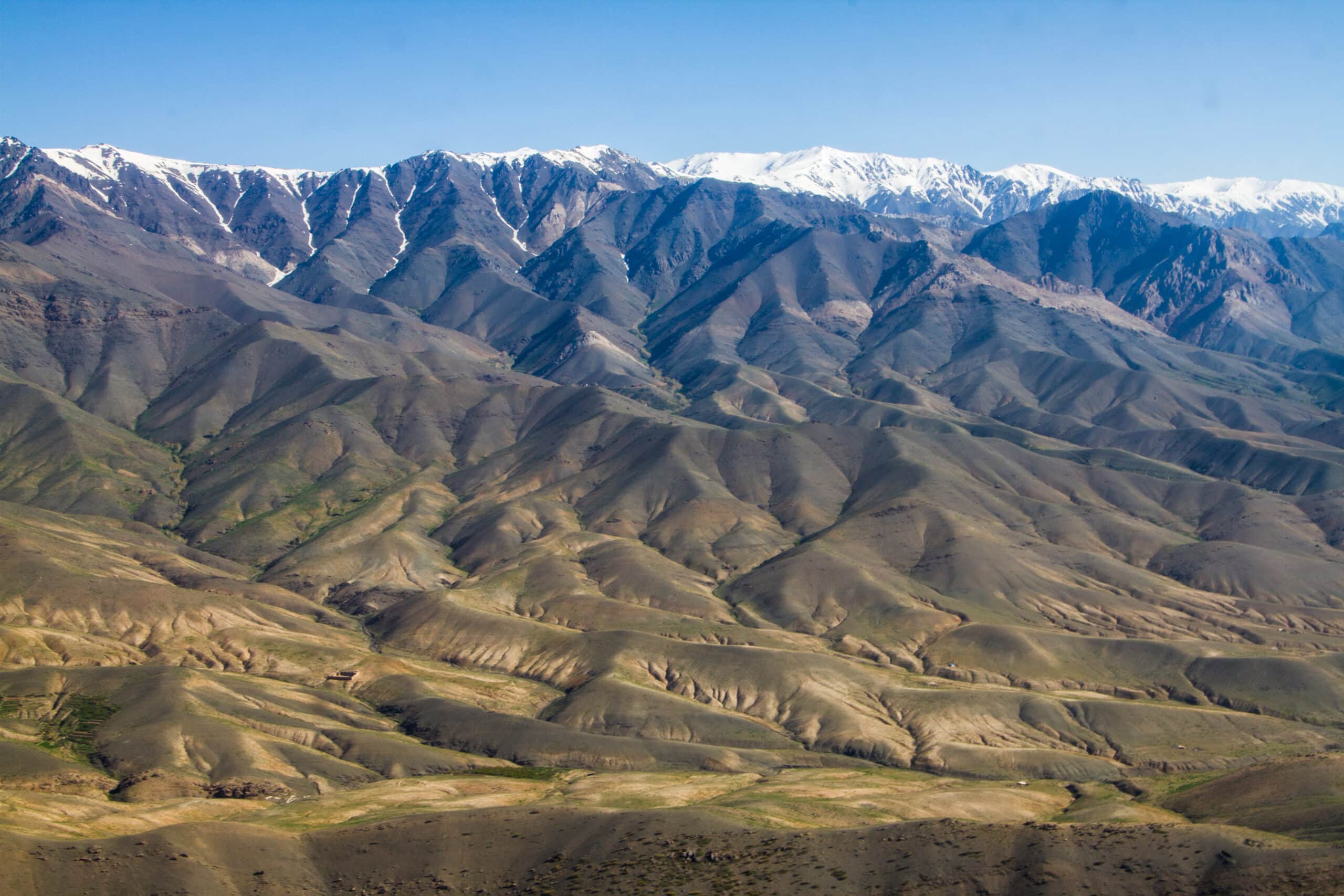
1. Hindu Kush Mountains
The Hindu Kush forms the central spine of Afghanistan, extending diagonally across the country from northeast to southwest. Geography here is monumental. Peaks rise above 7,000 meters, separating northern plains from southern basins through formidable elevation.
Glaciers crown the highest summits, feeding rivers that sustain valleys below. Geography defines national structure—climate patterns, transportation routes, and settlement clusters all respond to mountain placement. Passes carve limited corridors through otherwise continuous ridges.
The mountains create microclimates across short distances. Geography shapes variation between alpine snowfields, forested slopes, and arid foothills. Elevation influences agriculture, architecture, and seasonal movement.
Movement across the Hindu Kush demands ascent through winding passes and steep valleys. Geography reinforces transition through vertical change. Connectivity between regions relies on maintaining routes through challenging terrain.
The range inspires through scale and dominance. The land teaches endurance through persistence in high-altitude conditions, showing how resilience develops where geography imposes constraint but also supplies water and protection.
Endurance here is hydrological and structural. Glacial systems sustain downstream life, while rock formations test infrastructure and mobility. Strength depends on respect for terrain.
The Hindu Kush reflects an Afghanistan where resilience originates in mountain systems that shape every aspect of life. Visitors encounter a landscape that reinforces endurance as adaptation within a country defined by elevation and division.