
Gabon unfolds as one of Africa’s most quietly intact countries, a land where geography still leads and human presence follows with restraint. Positioned along the equator on the Atlantic coast of Central Africa, Gabon is defined less by cities or monuments than by ecosystems of extraordinary continuity. Rainforest dominates its interior, rivers carve long patient routes toward the sea, and coastlines remain shaped by tides rather than concrete. This is a country where nature is not scenery but structure.
More than eighty percent of Gabon is covered in forest, forming one of the largest remaining stretches of equatorial rainforest on Earth. These forests are not empty. They sustain complex systems of wildlife, waterways, and human communities whose lives are organized around rainfall, soil, and movement rather than extraction. Elephants walk from forest to beach, rivers function as roads, and seasons are read through water levels and light rather than calendars.
Gabon’s geography creates balance through contrast. Dense interior forests give way to open savannas, high plateaus rise above low wetlands, and quiet coastal lagoons meet the force of the Atlantic. Each transition zone carries its own rhythm and identity, reinforcing a national character built on coexistence rather than dominance. Urban centers remain compact and grounded, never fully detached from the ecosystems that surround them.
What distinguishes Gabon is not isolation but proportion. Development exists, yet it is measured against ecological permanence. Conservation is not an afterthought but a geographic necessity, reflected in a vast network of national parks protecting forest, savanna, rivers, and coast.
To travel through Gabon is to move through layers of time—geological, ecological, and cultural—where continuity outweighs urgency. It is a country that invites attention rather than consumption, offering meaning through depth, patience, and alignment with the land itself.
20. Libreville: Coastal Capital Between Forest and Sea
Libreville sits along Gabon’s Atlantic coast where dense equatorial forest meets open ocean. Its geography defines its identity as a capital shaped less by monumentality than by balance between land, water, and movement.
The city stretches parallel to the shoreline, oriented toward breezes, tides, and coastal access. Fishing villages, ports, and residential districts coexist, reinforcing continuity between traditional livelihoods and modern administration. The sea moderates climate and pace, preventing the city from overwhelming its surroundings.
Inland, forest presses close. Green corridors weave through neighborhoods, and vegetation remains a constant presence rather than a distant boundary. This proximity shapes urban consciousness, reinforcing awareness of ecological limits.
Libreville’s social life unfolds in markets, seaside promenades, and informal gathering spaces. Movement is steady rather than hurried, reflecting a capital that functions as connector rather than spectacle.
Libreville represents Gabon’s coastal equilibrium. It shows how a capital can exist in dialogue with its environment, sustaining identity through proximity and restraint rather than dominance.
19. Fernan Vaz Lagoon: Coastal Wetlands and Memory
The Fernan Vaz Lagoon lies along Gabon’s western coast as a vast estuarine system where rivers, mangroves, and the Atlantic Ocean converge. Its geography creates a landscape defined by movement and reflection.
Water dominates perception. Channels shift with tide and season, shaping fishing routes and settlement placement. Life here adapts through observation and inherited knowledge of currents.
Mangroves sustain biodiversity. Fish nurseries, bird habitats, and plant life depend on the lagoon’s brackish balance, reinforcing ecological interdependence.
Human presence remains light. Villages and paths follow natural contours, avoiding disruption. Travel occurs primarily by boat, reinforcing rhythm governed by water rather than road.
Fernan Vaz represents Gabon’s wetland continuity. It shows how coastal systems preserve meaning through subtlety, sustaining life and memory through flow and restraint.
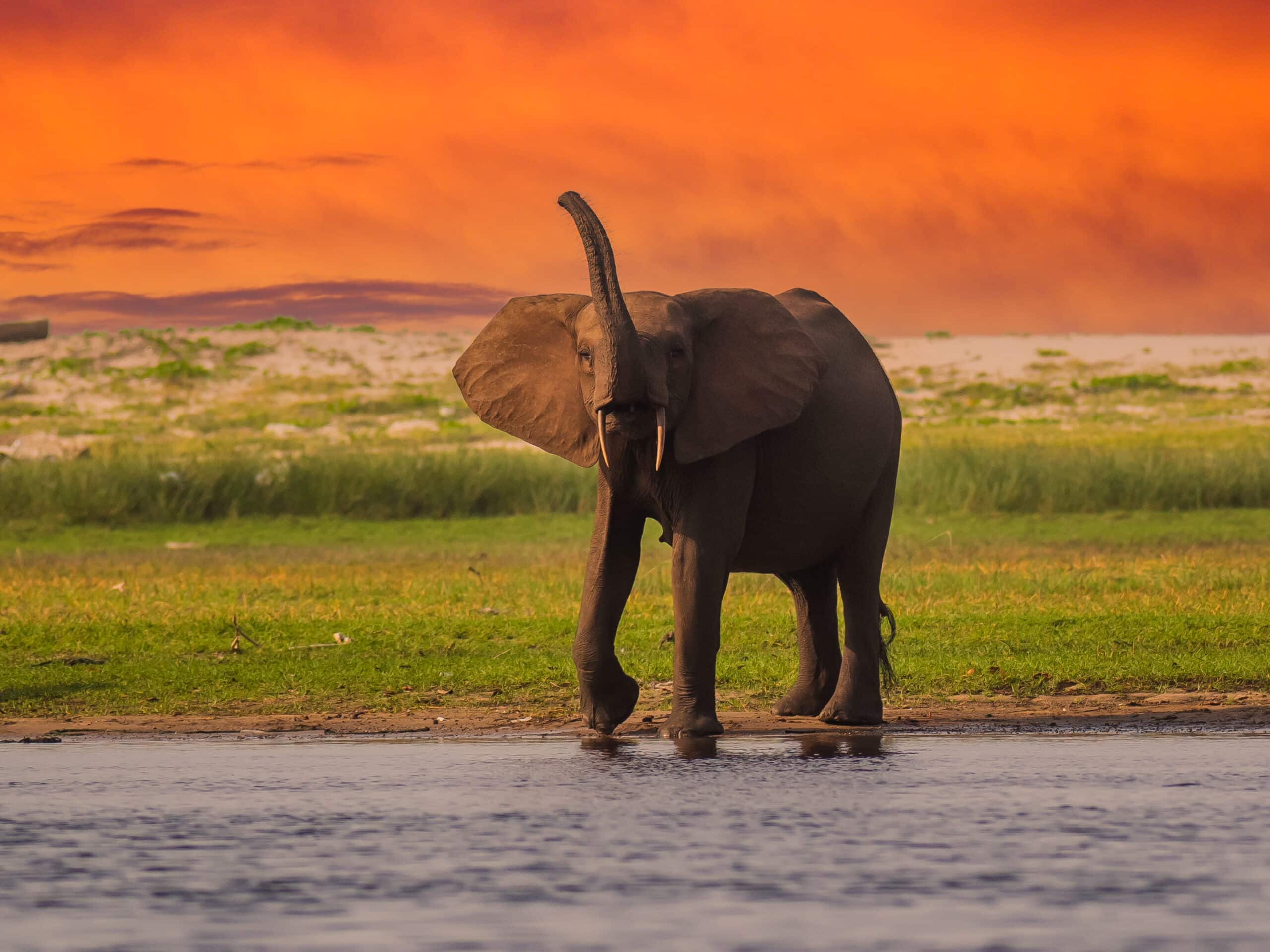
18. Loango National Park: Where Forest, Savanna, and Ocean Converge
Loango National Park lies along Gabon’s western coast as one of Africa’s most diverse protected landscapes. Here, rainforest, savanna, lagoons, and Atlantic beaches intersect without clear boundary.
Wildlife moves freely across ecosystems. Forest elephants emerge onto open beaches, hippos navigate lagoons, and birds follow seasonal patterns shaped by water and vegetation. Life adapts through mobility rather than confinement.
Human presence is minimal and deliberate. Access routes follow natural contours, emphasizing observation over intrusion. Conservation relies on space and continuity rather than enclosure.
The ocean plays a defining role. Tides influence lagoons and river mouths, shaping feeding cycles and migration patterns. The coast is dynamic, reinforcing constant adjustment.
Loango represents Gabon’s ecological synthesis. It shows how protection succeeds when landscapes remain whole, allowing systems to interact naturally. Here, convergence becomes resilience.
17. Lambaréné and the Ogooué River: Life Along a Waterway
Lambaréné lies along the Ogooué River, Gabon’s largest waterway and central artery. The town’s identity is inseparable from the river, which structures transport, economy, and daily rhythm.
Boats replace roads. Movement follows currents and channels, linking villages across forested interiors. Fishing, trade, and communication depend on water levels and seasonal flow.
Settlements cluster along riverbanks, elevated against flooding yet close enough for access. Architecture reflects adaptation—light structures, shaded spaces, and open alignment with water.
The river sustains agriculture through fertile banks and periodic flooding. Crops align with hydrological cycles, reinforcing knowledge passed through generations.
Lambaréné represents Gabon’s riverine coherence. It shows how waterways anchor social and ecological systems, sustaining continuity through flow rather than permanence. Here, the river is both path and provider.
16. Ivindo National Park: Forest Depth and Geological Time
Ivindo National Park occupies northeastern Gabon as a vast expanse of intact rainforest shaped by rivers, rock formations, and isolation. Its scale reinforces humility through depth and density.
The Ivindo River cuts through forest, forming waterfalls and rapids that expose ancient rock layers. These formations reveal geological time far exceeding human presence.
Biodiversity thrives through continuity. Dense canopy, understory, and waterways support countless species, many dependent on undisturbed habitat. Life here persists through balance rather than abundance.
Human access remains limited. Trails and research stations prioritize study and preservation, recognizing fragility beneath apparent vastness.
Ivindo represents Gabon’s forest core. It shows how depth and restraint sustain resilience, and how protection aligns with time rather than immediacy. Here, the forest endures through quiet continuity.
15. Port-Gentil: Island City of Tides and Industry
Port-Gentil sits on Mandji Island along Gabon’s Atlantic coast, defined by water on all sides and movement shaped by tide rather than road. As the country’s economic capital, it reflects a life oriented outward—toward the sea, offshore platforms, and shifting horizons.
The ocean structures daily rhythm. Fishing boats, supply vessels, and ferries punctuate time, while mangroves and estuaries buffer the city from open waters. Access remains deliberate, reinforcing the sense of separation that defines island living.
Industry plays a visible role. Energy infrastructure operates alongside residential districts, yet the city avoids sprawl. Its compact form maintains proximity between work, home, and shoreline.
Social life unfolds through markets, waterfront gatherings, and neighborhood ties strengthened by isolation. Movement is cyclical rather than linear, mirroring tides and return.
Port-Gentil represents Gabon’s maritime pragmatism. It shows how an industrial city can remain grounded in geography, sustained by water, rhythm, and restraint rather than scale.
14. Plateaux Batéké: Savannah Above the Forest
The Plateaux Batéké rise in southeastern Gabon as a highland savanna distinct from the surrounding rainforest. Rolling grasslands, sandy soils, and open skies create a landscape of exposure and distance.
Seasonal fires and rainfall shape vegetation, sustaining grasses rather than forest. Wildlife adapts through movement, grazing, and seasonal migration rather than concealment.
Human settlement remains sparse. Villages align with water sources and elevated ground, reinforcing adaptation to wind, soil, and climate variability. Agriculture remains limited and selective.
The plateau’s openness encourages perspective. Long sightlines and subtle elevation shifts contrast with the enclosure of forest regions, reinforcing awareness of space and vulnerability.
Plateaux Batéké represents Gabon’s geographic contrast. It shows how variation sustains national balance, and how openness can be as defining as density. Here, elevation becomes identity.
13. Mouila and the Ngounié Valley: Fertile Interior Corridor
Mouila lies within the Ngounié River valley of southern Gabon, a region shaped by fertility, rainfall, and interior connectivity. The valley functions as an agricultural corridor anchoring surrounding highlands.
Rivers sustain farming and transport. Cassava, plantain, and vegetables grow in abundance, structured by seasonal cycles and river flow. Knowledge of soil and water governs productivity.
The town serves as a regional hub. Markets connect rural producers with broader networks, reinforcing exchange through proximity rather than speed.
Settlement patterns emphasize balance. Villages remain integrated with fields and forest edges, sustaining livelihoods through mixed use rather than specialization.
Mouila represents Gabon’s agrarian continuity. It shows how interior valleys sustain cohesion through fertility, rhythm, and environmental familiarity.
12. Mayumba Coast: Southern Shores and Migration
The Mayumba coast stretches along Gabon’s southern Atlantic edge as a quiet shoreline shaped by sand, wind, and migration. Beaches extend uninterrupted, framed by forest and sea.
Marine life defines significance. Sea turtles return seasonally to nest, guided by instinct older than settlement. Conservation efforts protect these cycles through restraint and monitoring.
Human presence remains light. Fishing villages and small paths align with dunes and vegetation, minimizing disruption. Life adapts to weather and tides rather than permanence.
The coast’s remoteness reinforces stillness. Sound is dominated by waves and wind, creating an atmosphere of continuity rather than activity.
Mayumba represents Gabon’s coastal humility. It shows how protection rooted in geography preserves both wildlife and meaning. Here, the shore remains a place of return rather than departure.
11. Franceville: Highland Gateway of the Southeast
Franceville lies in southeastern Gabon near the borders of Congo and the Central African Republic, positioned on elevated terrain shaped by plateaus, rivers, and mineral-rich ground. Its geography defines it as a gateway rather than a terminus.
The surrounding landscape alternates between savanna and forest, creating a zone of transition that influences agriculture, settlement, and movement. Rivers such as the Mpassa structure life through water access, transport, and fertile banks.
The city’s layout reflects function over form. Administrative centers, schools, and residential districts remain compact, reinforcing accessibility and regional cohesion. Social life centers on markets and shared public spaces shaped by proximity.
Franceville’s inland position fosters resilience. Distance from the coast encourages self-reliance and regional exchange, connecting interior communities through road and river networks rather than maritime routes.
Franceville represents Gabon’s southeastern anchor. It shows how elevated inland cities sustain continuity through adaptation, grounding identity in transition landscapes that link forest, savanna, and neighboring regions.
10. Lopé National Park: Forest–Savanna Boundary
Lopé National Park occupies central Gabon as a landscape defined by contrast. Here, ancient rainforest meets open savanna, forming one of Central Africa’s most significant ecological boundaries.
This transition sustains biodiversity. Species adapted to forest canopy coexist with savanna dwellers, relying on seasonal movement and habitat overlap rather than isolation. Life here depends on permeability.
The terrain reveals deep time. Rock formations and archaeological sites indicate long human presence shaped by climate shifts and environmental adaptation. The land records continuity rather than rupture.
Human access remains controlled. Research stations and limited paths prioritize observation and preservation, reinforcing respect for fragile balance.
Lopé represents Gabon’s ecological dialogue. It shows how boundaries generate resilience, and how diversity thrives when landscapes remain connected rather than compartmentalized.
9. Tchibanga: Southern Interior and Cultural Persistence
Tchibanga lies in southern Gabon near forested lowlands and river systems feeding coastal plains. Its geography supports agriculture, trade, and cultural continuity rooted in interior landscapes.
Farming structures daily life. Cassava, bananas, and maize grow in fertile soils shaped by rainfall and river cycles. Agricultural rhythm reinforces community cooperation and seasonal awareness.
The town functions as a regional center. Markets link surrounding villages, sustaining exchange through familiarity rather than scale. Social life emphasizes kinship and shared labor.
Settlement remains modest. Homes and paths integrate with vegetation and water flow, reinforcing adaptation rather than transformation of landscape.
Tchibanga represents Gabon’s southern stability. It shows how interior towns preserve continuity through land-based livelihoods and social cohesion shaped by geography.
8. Akanda National Park: Mangroves and Urban Edge
Akanda National Park lies just north of Libreville, protecting mangroves, wetlands, and coastal forests along Gabon’s estuarine edge. Its proximity to the capital highlights coexistence between urban life and conservation.
Mangroves dominate the landscape. These tidal forests filter water, support fish nurseries, and buffer coastline erosion. Life here depends on tidal cycles rather than permanence.
Birdlife flourishes. Migratory species rely on mudflats and wetlands, reinforcing Akanda’s importance within global ecological networks.
Human activity is regulated. Boardwalks and observation zones allow access without disruption, emphasizing protection through restraint.
Akanda represents Gabon’s conservation threshold. It shows how ecological systems persist at urban edges when geography guides development. Here, mangroves sustain both nature and balance.
7. Oyem: Northern Crossroads of Forest and Trade
Oyem lies in northern Gabon near the borders with Cameroon and Equatorial Guinea, positioned within dense equatorial forest shaped by rainfall, agriculture, and regional exchange. Its geography defines it as a crossroads rather than a destination.
The surrounding forest supports farming and gathering, with cacao, plantain, cassava, and fruit trees forming the basis of livelihoods. Agriculture follows rainfall cycles, reinforcing familiarity with soil, shade, and seasonal variation.
Oyem’s role as a border town shapes movement. Trade routes and roads connect interior villages to neighboring countries, sustaining flow of goods, people, and ideas. Markets function as social anchors where regional networks converge.
Urban form remains compact and pragmatic. Administrative buildings, schools, and neighborhoods cluster around transport corridors, reinforcing accessibility rather than expansion.
Oyem represents Gabon’s northern connectivity. It shows how border regions sustain identity through exchange and adaptation, grounding continuity in forest landscapes that link rather than divide.
6. Ndendé: River Valley and Southern Rhythm
Ndendé lies in southern Gabon within a landscape shaped by rivers, rolling hills, and fertile valleys. Its environment supports agriculture and movement, anchoring life through water systems and land familiarity.
Rivers structure settlement. Villages align along banks and tributaries, balancing access with protection from flooding. Farming depends on seasonal cycles, reinforcing patience and cooperation.
The town functions as a local center for trade and administration. Markets connect rural producers with broader networks, sustaining exchange through proximity and trust rather than scale.
Social life emphasizes continuity. Family networks, shared labor, and agricultural rhythm sustain cohesion across generations.
Ndendé represents Gabon’s southern grounding. It shows how river valleys sustain stability through fertility and rhythm, reinforcing identity rooted in land and water alignment.
5. Minkébé National Park: Remote Forest and Scale
Minkébé National Park occupies northeastern Gabon as one of the country’s most remote and extensive forest reserves. Its vastness defines experience through scale and isolation.
Dense rainforest dominates, crossed by rivers and ridges that support wildlife adapted to minimal disturbance. Elephants, primates, and countless species rely on uninterrupted habitat.
Human access is extremely limited. Protection here emphasizes absence rather than presence, recognizing that remoteness itself sustains balance.
The park’s scale reframes perspective. Distance and density dissolve human centrality, reinforcing awareness of ecological time and endurance.
Minkébé represents Gabon’s forest immensity. It shows how preservation depends on restraint, allowing landscapes to persist through continuity rather than control.
4. Koulamoutou: Forest Capital of the Interior
Koulamoutou lies in east-central Gabon within dense rainforest shaped by rivers, rainfall, and interior isolation. Its geography defines it as a forest capital—anchored in depth rather than reach.
The surrounding landscape is dominated by towering trees, understory growth, and winding waterways. Agriculture and gathering shape livelihoods, with crops cultivated in forest clearings aligned to soil and water conditions.
Movement is deliberate. Roads connect Koulamoutou to neighboring regions, but daily life unfolds locally through footpaths, river routes, and neighborhood networks. Distance reinforces self-reliance.
The town functions as an administrative and cultural hub for surrounding communities. Markets, schools, and civic spaces sustain cohesion through proximity and shared rhythm rather than density.
Koulamoutou represents Gabon’s interior continuity. It shows how forest towns persist through adaptation and restraint, grounding identity in environments that demand respect rather than transformation.
3. Booué: River Junction and Passage
Booué lies along the Ogooué River where waterways intersect with forest corridors, shaping the town as a place of passage rather than destination. Its identity is defined by flow.
The river structures all movement. Boats carry people, goods, and information across long distances, linking interior regions to downstream centers. Seasonal water levels dictate rhythm and access.
Settlements align along riverbanks, elevated for protection yet close enough for daily use. Fishing, farming, and trade remain interconnected through water-based mobility.
Booué’s social life reflects transience. Travelers pass through, markets shift daily, and the town adapts continuously to changing flow.
Booué represents Gabon’s riverine impermanence. It shows how communities thrive through movement and flexibility, sustaining meaning through connection rather than permanence.
2. Nyanga Province: Southern Frontier Landscapes
Nyanga Province stretches across Gabon’s southern frontier, encompassing forests, rivers, and coastal zones shaped by distance and low population density. Its geography reinforces patience and continuity.
The landscape supports mixed livelihoods. Farming, fishing, and forest use coexist, aligned with seasonal cycles and environmental limits. Settlements remain dispersed and deliberate.
Movement across Nyanga follows rivers and sparse road networks, reinforcing regional isolation while sustaining local cohesion. Social ties bridge distance through kinship and shared memory.
The province’s remoteness preserves ecological integrity. Forests remain largely intact, and wildlife corridors persist across boundaries.
Nyanga represents Gabon’s frontier resilience. It shows how peripheral regions sustain balance through restraint, grounding identity in scale and environmental familiarity.
1. Woleu-Ntem Rivers: Northern Watershed
The Woleu-Ntem river system shapes northern Gabon through interconnected waterways feeding into broader Central African basins. Its geography sustains life through continuity rather than spectacle.
Rivers define settlement placement. Villages cluster near banks, balancing access to water with protection from seasonal flooding. Agriculture depends on fertile soils replenished by flow.
Movement follows water. Canoes and small boats link communities across forested interiors, reinforcing exchange through shared reliance on rivers.
The watershed connects Gabon to neighboring regions, reinforcing regional interdependence shaped by hydrology rather than borders.
Woleu-Ntem represents Gabon’s hydrological unity. It shows how rivers anchor cultural and ecological continuity, sustaining life through flow, memory, and shared geography.