
Madagascar is not simply an island; it is a world set apart. Separated from mainland Africa for over eighty million years, it evolved in isolation, allowing life to follow its own logic, pace, and imagination. The result is a place unlike anywhere else on Earth, where landscapes feel ancient, species feel mythical, and culture reflects a deep dialogue between land and survival.
Geographically, Madagascar is vast and varied. Rainforests cloak the eastern escarpment, absorbing moisture from the Indian Ocean. Central highlands rise into cooler plateaus shaped by terraced agriculture and historic kingdoms. To the west and south, dry forests, canyons, and spiny deserts dominate, sculpted by scarcity and resilience. This diversity creates not contrast, but continuity—each region adapting to its conditions with remarkable precision.
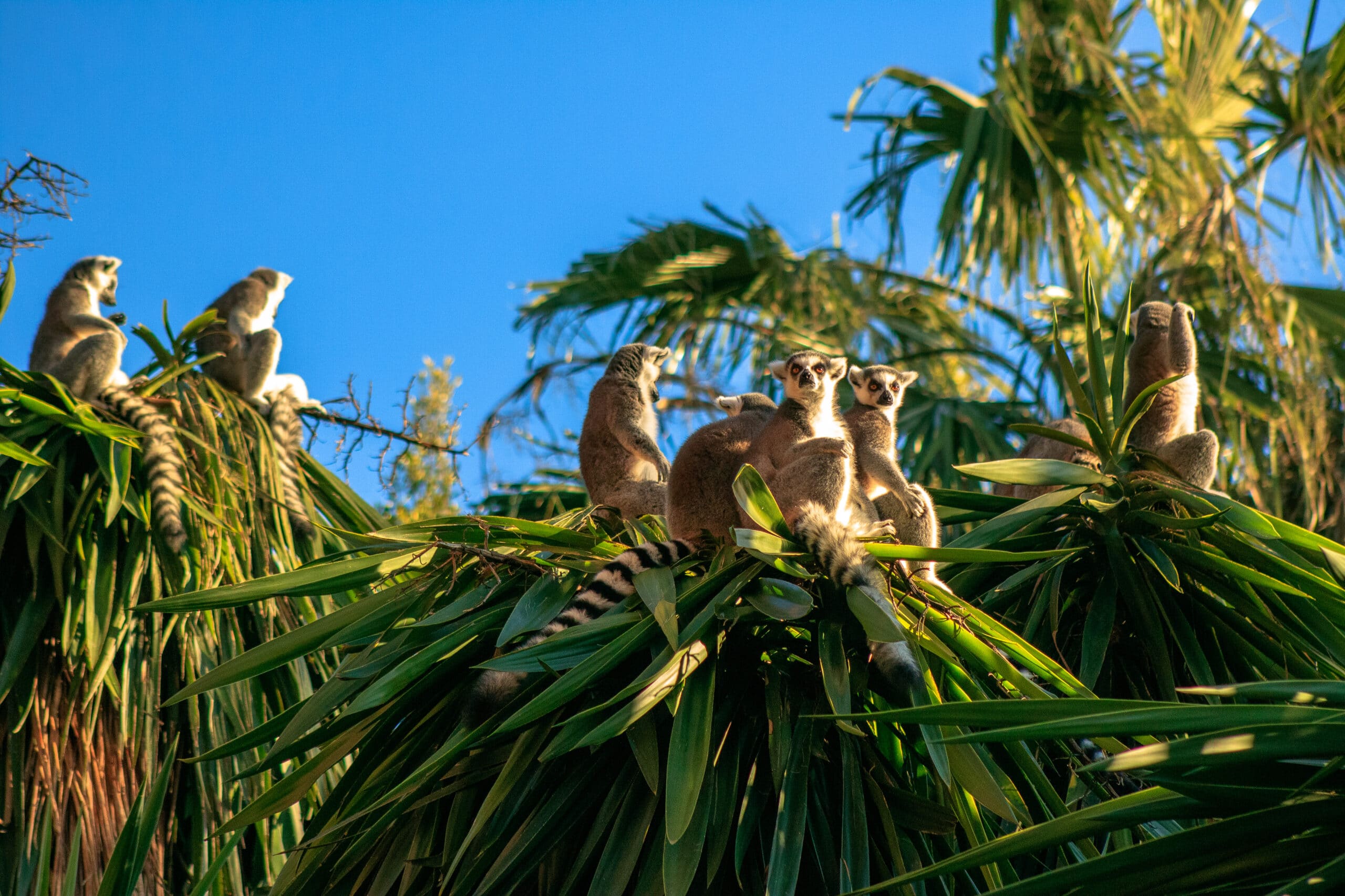
Madagascar’s biodiversity is legendary. The majority of its plants and animals exist nowhere else. Lemurs, baobabs, chameleons, and orchids evolved without external competition, becoming symbols of both wonder and vulnerability. Conservation here is not abstract; it is essential to global ecological heritage.
Culturally, Madagascar reflects layered influence. Austronesian seafarers, African traditions, Arab trade, and European contact shaped a society rooted in ancestry, land stewardship, and ritual. Respect for elders, burial traditions, and spiritual ties to nature remain central to Malagasy identity.
Travel in Madagascar requires patience. Roads are slow, distances deceptive, and comfort secondary to authenticity. Yet this deliberate pace preserves the island’s integrity. Madagascar does not offer convenience—it offers truth.
16. Avenue of the Baobabs: Time Standing Upright

The Avenue of the Baobabs rises near Morondava as one of Madagascar’s most iconic landscapes, where towering trees line a sandy track like ancient guardians. These baobabs, some over eight hundred years old, are not forest remnants but survivors—standing witnesses to environmental change and human history.
Baobabs evolved to store water within massive trunks, allowing them to thrive in arid conditions. Their ability to endure drought reflects Madagascar’s broader narrative of adaptation through scarcity. Stripped of leaves during the dry season, they appear inverted, as if roots reach skyward.
The avenue’s power lies in simplicity. No dense vegetation obscures the view, and the land opens toward horizon and sky. At sunrise and sunset, light transforms the scene into quiet spectacle, where shadow, color, and scale dominate perception.
Local communities regard the baobabs with reverence. They are embedded in folklore and belief, symbolizing ancestry, protection, and continuity. Their survival amid deforestation reinforces the urgency of conservation.
The Avenue of the Baobabs is not merely photogenic; it is symbolic. It shows how resilience becomes beauty when time is allowed to work undisturbed. Standing among these giants, one feels small not because of insignificance, but because endurance commands respect. Madagascar speaks here through stillness, reminding visitors that survival itself can become monument.
15. Andasibe-Mantadia National Park: Forest of First Voices
Andasibe-Mantadia National Park lies east of Antananarivo as a rainforest sanctuary defined by sound, mist, and vertical life. This is one of Madagascar’s most accessible yet biologically rich protected areas.
The forest is famous for the indri, the island’s largest lemur. Its haunting calls echo through the canopy at dawn, marking territory and presence. These vocalizations feel primal, reinforcing the forest as a living organism rather than a backdrop.
Dense vegetation creates layered ecosystems. Moss-covered trunks, orchids, and ferns support insects, reptiles, and birds found nowhere else. Movement here is upward and inward, shaped by branches rather than paths.
Conservation in Andasibe balances research, tourism, and community involvement. Local guides bring generational knowledge, reinforcing stewardship through livelihood rather than exclusion.
Andasibe reveals Madagascar’s intimacy. It teaches attention—to sound, movement, and subtle change. This forest does not overwhelm; it invites listening. In doing so, it offers one of the clearest introductions to the island’s evolutionary soul.
14. Antananarivo: Highlands of Memory and Motion
Antananarivo, Madagascar’s capital, rises across the central highlands as a city shaped by elevation, history, and endurance. Built on ridges and valleys, it reflects centuries of political power, colonial transformation, and modern adaptation.
The city’s heart lies in its upper town, where former royal compounds and historic churches overlook dense neighborhoods below. This vertical layout mirrors social and historical layering, where past authority and present life intersect visibly.
Markets, workshops, and street life animate the lower city. Commerce here is informal but essential, driven by resilience rather than expansion. Antananarivo moves quickly in places, slowly in others, responding to terrain rather than planning.
Despite challenges, cultural identity remains strong. Music, language, and communal ties shape daily interaction. The city serves as Madagascar’s intellectual and administrative center, negotiating tradition and modernity simultaneously.
Antananarivo represents Madagascar’s human dimension. It shows how history, hardship, and hope coexist, grounding the island’s natural wonders in lived experience.
13. Tsingy de Bemaraha: Stone Forest of Extremes
Tsingy de Bemaraha National Park stands in western Madagascar as one of the most extreme geological landscapes on Earth. Sharp limestone pinnacles rise into dense formations, creating a “stone forest” shaped by erosion over millions of years.
Movement through the Tsingy is deliberate and physical. Narrow bridges, ladders, and crevices require focus and respect. This difficulty preserves isolation and biodiversity.
Plants and animals adapted uniquely to this terrain thrive within cracks and elevated platforms. Lemurs, birds, and reptiles navigate vertical space with ease, illustrating evolution shaped by challenge.
The Tsingy is both barrier and sanctuary. It protects life through inaccessibility, reinforcing the relationship between terrain and survival.
This landscape reveals Madagascar’s raw ingenuity. It demonstrates how life persists even where the land appears hostile, completing a portrait of an island shaped by adaptation rather than abundance.
12. Isalo National Park: Canyon of Wind and Time
Isalo National Park unfolds across southern Madagascar as a landscape shaped by erosion, endurance, and elemental contrast. Sandstone massifs rise from open plains, carved over millions of years by wind and water into deep canyons, sculpted cliffs, and hidden pools. The result is a terrain that feels both ancient and alive.
Unlike Madagascar’s rainforests, Isalo is defined by openness. Grasslands stretch between rocky formations, while narrow gorges shelter palms, ferns, and clear streams. These oases sustain life amid aridity, forming micro-ecosystems where lemurs, birds, and reptiles survive through adaptation.
The park holds deep cultural significance for the Bara people, who regard the canyons as sacred burial grounds. Tombs hidden within rock walls reinforce the connection between land and ancestry, turning geography into memory. Movement through Isalo is therefore both physical and spiritual, guided by respect.
Hiking reveals constant transition. Heat gives way to shade, silence to birdsong, stone to water. Natural pools invite rest, offering rare refreshment in an otherwise demanding environment. These contrasts define Isalo’s emotional power.
Isalo National Park embodies Madagascar’s southern character—resilient, austere, and quietly profound. It shows how life organizes itself around scarcity, and how beauty emerges from survival rather than abundance. In Isalo, the land does not soften itself for visitors. Instead, it asks for patience, awareness, and humility, rewarding those qualities with perspective and timeless scale.
11. Nosy Be: Island of Fragrance and Light
Nosy Be rests off Madagascar’s northwest coast as an island shaped by scent, sea, and slow rhythm. Known as the “Perfume Island,” it carries the aroma of ylang-ylang, vanilla, and spices, blending natural abundance with cultural warmth.
Volcanic origins give Nosy Be rolling hills and fertile soil, supporting lush vegetation and vibrant agriculture. Beaches curve gently into clear waters, protected by coral reefs that shelter marine life. The island’s scale encourages ease rather than urgency, inviting lingering rather than conquest.
Marine ecosystems define daily life. Fishing villages line the coast, and boats move between islands carrying people, goods, and tradition. Whales migrate offshore seasonally, reinforcing Nosy Be’s connection to larger natural cycles.
Cultural influence here is layered. African, Arab, and European traces appear in architecture, cuisine, and language, yet local identity remains central. Music, hospitality, and communal gathering shape interaction, preserving authenticity despite growing tourism.
Nosy Be represents Madagascar’s gentler side. It offers contrast to the island’s harsher interiors, proving that resilience can coexist with generosity. The island does not overwhelm with spectacle; it comforts through harmony.
In Nosy Be, Madagascar exhales. Land and sea collaborate rather than compete, reminding visitors that balance itself can be extraordinary.
10. Ranomafana National Park: Rain, Renewal, and Research
Ranomafana National Park lies along Madagascar’s southeastern rainforest belt, where rainfall defines rhythm and biodiversity thrives in density. Mist hangs constantly over the canopy, feeding one of the island’s most complex ecosystems.
The park gained global recognition through scientific discovery, particularly the identification of the golden bamboo lemur. Research remains central here, with conservation science integrated into protection strategies. Ranomafana represents collaboration between global knowledge and local stewardship.
Dense forest layers support extraordinary diversity. Ferns, mosses, orchids, insects, and amphibians occupy every vertical level, creating constant movement and sound. Trails wind through humid corridors where attention becomes essential, as life reveals itself slowly.
Nearby communities participate in conservation through education and employment, linking survival to sustainability rather than exploitation. This partnership strengthens both environment and society.
Ranomafana demonstrates Madagascar’s future. It shows that preservation depends not on isolation, but on shared responsibility. The forest is not frozen in time—it is actively studied, protected, and lived with.
Here, renewal is constant. Rain falls, growth responds, and balance is maintained through vigilance. Ranomafana is not dramatic; it is profound. It teaches that continuity, when protected, becomes the greatest achievement of all.
9. Ifaty and the Southern Coast: Where Desert Meets Sea
The southern coast near Ifaty presents one of Madagascar’s most striking contrasts. Spiny desert vegetation reaches toward turquoise waters, forming an environment where land and sea meet without transition.
Baobabs and thorny plants dominate inland terrain, adapted to drought and poor soil. Offshore, coral reefs support vibrant marine ecosystems. This proximity creates dual dependence, where communities rely equally on fishing and pastoral survival.
Vezo fishing culture defines the coast. Knowledge of tides, winds, and reefs passes through generations, reinforcing identity shaped by movement rather than settlement. Boats are handmade, navigation intuitive.
Despite environmental fragility, life persists through understanding rather than force. Conservation efforts focus on reef protection and sustainable fishing, recognizing that balance ensures survival.
Ifaty reveals Madagascar’s extremes in harmony. It shows how adaptation bridges desert and ocean, completing the island’s ecological spectrum. Here, survival is not a struggle—it is a practiced art.
8. Île Sainte-Marie: Island of Whales and Memory
Île Sainte-Marie, also known as Nosy Boraha, stretches along Madagascar’s eastern coast as a slender island shaped by sea, history, and seasonal return. Once a pirate haven and trading outpost, it now carries a quieter legacy defined by migration—both human and marine.
Between July and September, humpback whales arrive in the warm waters surrounding the island to breed and calve. Their presence transforms the coastline into a living theater of migration, reinforcing Madagascar’s role within global ecological cycles. Whale sightings here are intimate, framed by calm seas and low-impact observation.
On land, the island moves at a measured pace. Palm-lined beaches, fishing villages, and inland forests create a setting where life unfolds slowly. Cemeteries from the pirate era sit beside churches and rice fields, blending myth and memory without spectacle.
Cultural identity remains strong. Music, oral history, and communal traditions shape daily interaction. The island’s isolation preserved both language and rhythm, allowing continuity rather than reinvention.
Île Sainte-Marie offers reflection rather than excitement. It reveals Madagascar’s connection to the wider ocean world while maintaining local integrity. Here, history does not dominate—it coexists. The island teaches that movement, when cyclical and respectful, strengthens rather than erases identity.
7. Masoala National Park: Where Forest Meets Ocean
Masoala National Park occupies Madagascar’s northeastern peninsula as the country’s largest protected rainforest. It is a place of convergence, where dense tropical forest descends directly into the Indian Ocean, creating one of the island’s most complex ecosystems.
Rainfall is constant, feeding rivers that support mangroves, coral reefs, and terrestrial biodiversity in seamless transition. Lemurs, birds, insects, and marine species exist within interconnected systems rather than isolated zones.
Access to Masoala is difficult, and that difficulty preserves its integrity. Trails are narrow, villages small, and infrastructure minimal. This remoteness ensures that human presence remains measured and intentional.
Community-based conservation defines the park’s management. Local populations depend on sustainable fishing, agroforestry, and ecotourism, reinforcing stewardship through participation rather than restriction.
Masoala represents Madagascar’s ecological completeness. It shows how forest and ocean function as one living system, each supporting the other. This integration makes Masoala not just biologically important, but conceptually powerful.
The park teaches that preservation requires respect for complexity. Nothing here exists alone. Masoala stands as a reminder that nature’s greatest strength lies in connection, not dominance.
6. Antsirabe: Highlands of Craft and Continuity
Antsirabe rests within Madagascar’s central highlands as a city shaped by altitude, craftsmanship, and quiet persistence. Cooler temperatures and fertile land made it a historic retreat, while mineral springs gave it early prominence.
Today, Antsirabe is known for artisanal production. Workshops create metal goods, textiles, and hand-carved objects that support local economy and cultural continuity. Craft here is not nostalgic—it is functional, adaptive, and essential.
The city’s layout reflects colonial influence layered over Malagasy structure. Rickshaws move through broad streets, blending tradition and adaptation. Markets anchor social life, reinforcing exchange as community rather than transaction.
Antsirabe also serves as a regional agricultural center. Surrounding fields produce vegetables, grains, and dairy, linking urban life directly to rural rhythms.
Unlike larger cities, Antsirabe does not seek expansion. It sustains itself through balance. The pace is deliberate, shaped by season and labor rather than demand.
Antsirabe represents Madagascar’s interior resilience. It demonstrates how cultural skill, environmental suitability, and social cohesion create durability. The city reminds visitors that progress does not require speed—only continuity and care.
5. Ankarana Reserve: Limestone, Shadow, and Survival
Ankarana Special Reserve rises in northern Madagascar as a dramatic limestone plateau marked by caves, canyons, and tsingy formations. Though smaller than Bemaraha, Ankarana offers equal intensity through density and vertical complexity.
Underground rivers carve vast cave systems beneath sharp pinnacles, creating hidden ecosystems that sustain bats, crocodiles, and specialized insects. Above ground, dry forests cling to rock, supporting lemurs and endemic plant life adapted to thin soil.
Movement through Ankarana alternates between open exposure and enclosed darkness. Bridges span deep gorges, while cave passages reveal geological time compressed into stone.
Local communities recognize the reserve as both resource and heritage. Sacred sites and oral traditions connect landscape to ancestry, reinforcing respectful use rather than extraction.
Ankarana completes Madagascar’s geological narrative. It shows how life adapts not only to climate, but to constraint. The reserve is harsh, beautiful, and uncompromising—yet full of movement and survival.
Here, Madagascar speaks through stone and shadow, reminding us that endurance often thrives where conditions seem least forgiving.
4. Zafimaniry Cultural Landscape: Wood, Belief, and Belonging
The Zafimaniry Cultural Landscape unfolds in Madagascar’s central highlands as a living expression of craftsmanship, belief, and continuity. Home to the Zafimaniry people, this region is internationally recognized for its intricate woodcarving tradition, which permeates architecture, objects, and daily life.
Villages are built almost entirely of wood, assembled without nails. Doors, windows, pillars, and furniture are carved with symbolic geometric patterns that reflect ancestral values, cosmology, and social order. Each motif carries meaning, transforming domestic space into cultural narrative.
Craftsmanship here is not decorative—it is identity. Skills pass through generations, taught through observation and practice rather than formal instruction. The act of carving reinforces patience, respect, and belonging, embedding culture into material form.
The surrounding landscape supports this way of life. Terraced hills, forests, and footpaths connect villages through physical effort rather than infrastructure, reinforcing self-sufficiency and communal interdependence.
Modern pressures challenge continuity. Access to alternative materials and economic change threaten traditional practice. Yet cultural preservation efforts emphasize living tradition rather than museum display, supporting adaptation without erasure.
The Zafimaniry Landscape represents Madagascar’s intangible heritage made visible. It shows how culture can be built, quite literally, into everyday life. Here, survival is not only ecological—it is cultural. Through wood and memory, the Zafimaniry demonstrate that tradition endures when it remains useful, meaningful, and shared.
3. Marojejy National Park: Rainforest in Vertical Motion
Marojejy National Park rises in northeastern Madagascar as a dramatic mountain rainforest where elevation defines biodiversity. Slopes ascend from lowland forest to cloud-covered peaks, creating layered ecosystems within a compact area.
Rainfall shapes everything. Moisture feeds dense vegetation, rivers, and mist that drapes the upper elevations. This vertical gradient supports exceptional species diversity, including rare lemurs, amphibians, and high-altitude plants found nowhere else.
Trails through Marojejy are demanding, climbing steep terrain where movement slows and attention sharpens. The difficulty of access preserves ecological integrity, limiting human impact while rewarding perseverance.
Local communities engage in conservation through partnership, recognizing that protection ensures long-term survival. Research and monitoring strengthen understanding of climate sensitivity and species adaptation.
Marojejy feels dynamic. Sound, movement, and shifting weather create constant change. Unlike static landscapes, this forest evolves visibly, reminding visitors that nature is process, not object.
The park represents Madagascar’s vertical complexity. It shows how altitude creates opportunity for life to diversify rather than diminish. Marojejy teaches that resilience often lies in gradient—where change itself becomes shelter.
2. Fianarantsoa: City of Learning and Faith
Fianarantsoa sits in Madagascar’s southern highlands as a city shaped by education, religion, and layered history. Its name, meaning “where one learns good,” reflects its longstanding role as an intellectual and spiritual center.
Founded in the nineteenth century, the city developed around missionary schools and churches that introduced literacy and formal education. These institutions remain influential, anchoring Fianarantsoa’s identity in learning and discourse.
The old town climbs steep hills, marked by churches and colonial-era buildings that overlook modern neighborhoods below. This elevation mirrors cultural hierarchy, where tradition and belief maintain visible presence.
Markets, universities, and transport routes link Fianarantsoa to surrounding agricultural regions. Tea plantations and vineyards nearby reflect adaptation to highland climate and soil.
Despite modernization, communal values remain strong. Faith, family, and education guide social life, reinforcing cohesion amid change.
Fianarantsoa represents Madagascar’s intellectual resilience. It shows how knowledge, belief, and place can coexist without dominance. The city does not impose authority—it cultivates understanding. In doing so, it anchors the island’s future in reflection rather than reaction.
1. Lokobe National Park: Last Forest of Nosy Be
Lokobe National Park preserves the last remaining primary rainforest on Nosy Be, offering a concentrated glimpse into Madagascar’s original coastal ecosystems. Small in size but rich in life, it stands as a reminder of what once covered much of the island.
Mangroves, towering trees, and dense undergrowth define the park’s interior. Lemurs, chameleons, frogs, and birds inhabit tight ecological niches, surviving through specialization and balance.
Access to Lokobe is guided and controlled. Canoes glide through mangroves, reinforcing the park’s fragility and the importance of low-impact movement. Silence dominates, allowing nature to define pace.
Local communities manage the park collaboratively, linking conservation with livelihood. This model reinforces protection through responsibility rather than restriction.
Lokobe represents Madagascar in miniature. It demonstrates how biodiversity concentrates where space is protected and intention is clear. The park’s small scale amplifies its significance.
Here, preservation feels intimate. Lokobe teaches that safeguarding even fragments of original landscape preserves memory, function, and hope. It closes Madagascar’s narrative by showing that protection, when shared, can be both effective and enduring.