
China is the world’s third-largest country by land area, stretching from the Pacific coastline in the east to high plateaus and deserts in the west. Its geography is vast and highly varied, encompassing some of Earth’s most dramatic landscapes — towering mountains, expansive river basins, arid deserts, fertile plains, and subtropical coastlines.
Western China is dominated by high elevations, particularly the Tibetan Plateau, often called the “Roof of the World.” This immense uplifted region was formed by the ongoing collision between the Indian and Eurasian tectonic plates. From this plateau rise major mountain ranges including the Himalayas, Kunlun, and Tianshan.
Moving eastward, elevation gradually decreases into basins and deserts such as the Tarim Basin and the Gobi Desert. Further east lie fertile lowlands shaped by two of Asia’s most important river systems: the Yellow River (Huang He) and the Yangtze River (Chang Jiang). These rivers deposit nutrient-rich sediments that sustain agriculture across northern and central China.
Southern China features karst landscapes, subtropical hills, and monsoon-influenced river valleys. Along the eastern seaboard, long coastlines open onto the Yellow Sea, East China Sea, and South China Sea, supporting major port cities and maritime trade.
China’s climate ranges from subarctic conditions in the northeast to tropical environments in the far south. The East Asian monsoon strongly influences rainfall patterns, delivering heavy summer precipitation to much of the country.
Geologically and climatically, China is a land of contrasts — high plateau and low delta, desert and rainforest, glacier and rice field. In the chapters ahead, China will be explored through its mountains, rivers, deserts, plains, and coastal regions.
26. Beijing
Beijing lies in northern China at the northern edge of the North China Plain. Geography here is transitional — flat alluvial lowlands bordered by mountains to the north and west.
The city sits on sediments deposited by rivers flowing from the Taihang and Yanshan mountain ranges. These uplands form natural barriers that historically influenced settlement and defense.
The North China Plain is one of the country’s most important agricultural regions, sustained by the Yellow River system and seasonal monsoon rains. However, rainfall is moderate and highly seasonal, arriving primarily during summer.
The climate is continental monsoon, with hot, humid summers and cold, dry winters influenced by Siberian air masses.
Geologically, the region rests on thick alluvial deposits overlying stable continental crust. Seismic activity occurs due to regional fault systems, though major earthquakes are infrequent.
Endurance here is climatic and hydrological. Water scarcity and groundwater management remain significant challenges in this densely populated plain.
Beijing reflects northern China’s geographic structure — fertile lowland framed by protective mountains. Visitors encounter expansive plains and distant ridges that illustrate the interplay between river sedimentation and upland geology.
25. Shanghai
Shanghai is located on China’s eastern coast at the mouth of the Yangtze River. Geography here is deltaic lowland formed by centuries of sediment deposition.
The Yangtze, Asia’s longest river, carries vast amounts of silt from western highlands to the East China Sea. Over time, these sediments created the Yangtze River Delta, one of the most fertile and economically significant regions in China.
The terrain is extremely flat and low-lying, with an intricate network of waterways, canals, and tidal channels. The Huangpu River flows through the city before joining the Yangtze estuary.
The climate is humid subtropical, with hot summers, monsoon rains, and mild winters. Typhoons occasionally impact the coastal region.
Geologically, Shanghai rests on deep alluvial and marine sediments, making land subsidence and flood protection ongoing concerns.
Endurance here is fluvial and coastal. Sea-level rise, storm surges, and river management are central to long-term sustainability in this delta environment.
Shanghai reflects eastern China’s maritime geography — river-built, sea-facing, and monsoon-influenced. Visitors encounter expansive waterways and flat horizons that demonstrate the power of sedimentary processes shaping the coastline.
24. Xi’an
Xi’an lies in central China within the Guanzhong Plain, bordered by the Qinling Mountains to the south and the Loess Plateau to the north.
The city sits along the Wei River, a tributary of the Yellow River. Over millennia, wind-blown loess — fine, fertile silt carried from desert regions — accumulated across the surrounding plateau.
The Loess Plateau is highly erodible, forming steep gullies and terraced slopes. Seasonal monsoon rains carve deep channels into the soft sediment.
The Qinling Mountains act as a climatic divide between northern and southern China, influencing rainfall patterns and biodiversity.
The climate is temperate continental with hot summers, moderate rainfall, and cold winters.
Geologically, the region consists of thick loess deposits overlying older sedimentary and crystalline rock. Soil erosion remains a major environmental concern due to the loose structure of loess.
Endurance here is erosional and climatic. Sustainable land management and reforestation are essential to reduce sediment loss into the Yellow River basin.
Xi’an reflects central China’s transitional geography — wind-deposited plateau and river valley bordered by mountain ranges. Visitors encounter terraced hills and fertile plains shaped by both wind and water over thousands of years.
23. Guangzhou
Guangzhou lies in southern China along the Pearl River Delta near the South China Sea. Geography here is low-lying deltaic plain formed by sediment carried from inland river systems.
The Pearl River (Zhujiang) network drains much of southern China before dispersing into a complex web of distributaries and estuaries. Over thousands of years, sediment accumulation created fertile floodplains and wetlands across Guangdong Province.
The terrain is flat and interlaced with waterways, tidal channels, and reclaimed land. Mangroves and estuarine ecosystems occupy portions of the delta.
The climate is humid subtropical, characterized by hot, wet summers and mild winters. The East Asian monsoon delivers heavy rainfall, while typhoons periodically affect the coastal region.
Geologically, Guangzhou sits on thick layers of alluvial and marine sediments. Land subsidence and flood control are long-term environmental considerations in this rapidly urbanizing delta.
Endurance here is fluvial and coastal. Sustainable river management and storm protection are central to maintaining stability in the Pearl River basin.
Guangzhou reflects southern China’s delta geography — river-built, monsoon-fed, and sea-facing. Visitors encounter expansive waterways and flat horizons that demonstrate the dynamic interaction between inland rivers and coastal tides.
22. Chengdu
Chengdu is located in southwestern China within the Sichuan Basin. Geography here is enclosed fertile lowland surrounded by mountains.
The basin is bordered by the Tibetan Plateau to the west and high mountain ranges on other sides, creating a natural enclosure. Rivers descending from the plateau deposit rich sediments across the plain.
The Min River, a tributary of the Yangtze, flows near the city and historically supported extensive irrigation networks. The basin’s flat terrain and fertile soils make it one of China’s most productive agricultural regions.
The climate is humid subtropical, with frequent cloud cover, moderate rainfall, and relatively mild winters compared to northern China.
Geologically, the Sichuan Basin consists of thick sedimentary rock layers formed over millions of years. Surrounding tectonic activity along the plateau margin makes the region seismically sensitive.
Endurance here is fluvial and tectonic. Water control systems and earthquake preparedness remain vital in this enclosed basin.
Chengdu reflects southwestern China’s basin geography — fertile, river-fed, and mountain-ringed. Visitors encounter expansive plains framed by distant peaks that illustrate the contrast between lowland productivity and highland tectonics.
21. Lhasa
Lhasa lies on the Tibetan Plateau at an elevation of approximately 3,650 meters above sea level. Geography here is high-altitude plateau shaped by continental collision.
The Tibetan Plateau was formed by the ongoing convergence of the Indian and Eurasian tectonic plates, lifting vast regions to extreme elevations. Surrounding mountains include segments of the Himalayas and Transhimalayan ranges.
The terrain consists of broad valleys, alpine grasslands, and snow-capped peaks. The Lhasa River, a tributary of the Yarlung Tsangpo (upper Brahmaputra), flows through the region.
The climate is highland continental, with strong solar radiation, cool summers, and cold winters. Precipitation is limited compared to monsoon-dominated eastern China.
Geologically, the region remains tectonically active, with frequent minor earthquakes and ongoing uplift.
Endurance here is climatic and tectonic. Adaptation to thin air, intense sunlight, and seismic conditions defines life on the plateau.
Lhasa reflects western China’s high-altitude geography — elevated, tectonically dynamic, and climatically extreme. Visitors encounter vast open landscapes and towering peaks that demonstrate the immense geological forces shaping the Roof of the World.
20. Guilin
Guilin lies in southern China within the Guangxi Zhuang Autonomous Region. Geography here is dominated by dramatic karst limestone formations shaped by millions of years of chemical weathering.
The region’s distinctive cone-shaped hills and steep limestone towers formed as slightly acidic rainwater dissolved soluble carbonate rock. Over geological time, underground caverns collapsed and erosion sculpted isolated peaks rising from relatively flat valley floors.
The Li River flows through the landscape, carving gentle bends between karst formations. Seasonal monsoon rains feed the river system, sustaining agriculture in the surrounding valleys.
The climate is humid subtropical, with hot summers and abundant rainfall during the monsoon season. Lush vegetation thrives in the fertile lowlands between limestone hills.
Geologically, Guilin’s terrain consists primarily of Devonian and Carboniferous limestone deposited in ancient shallow seas. Continued erosion maintains the region’s striking topography.
Endurance here is erosional and hydrological. Water quality preservation and careful land management are essential to protect fragile karst systems.
Guilin reflects southern China’s karst geography — limestone-shaped, river-carved, and monsoon-fed. Visitors encounter steep green peaks and winding waterways that illustrate the long-term interaction between rainfall and soluble rock.
19. Harbin
Harbin is located in northeastern China near the Songhua River. Geography here is broad river plain influenced by continental climatic extremes.
The city sits within the Northeast China Plain, one of the country’s major agricultural regions. The Songhua River, a tributary of the Amur River system, provides water resources and shapes local floodplains.
The terrain is largely flat, with fertile soils formed through sediment deposition and glacial processes during past ice ages. Surrounding regions include forested uplands and wetlands.
The climate is humid continental, characterized by long, severe winters and short, warm summers. Siberian air masses dominate winter conditions, bringing heavy snowfall and freezing temperatures.
Geologically, the region rests on ancient crystalline bedrock overlain by glacial and river sediments. Seasonal freeze-thaw cycles influence soil structure and hydrology.
Endurance here is climatic. Infrastructure and agriculture must adapt to prolonged freezing conditions and short growing seasons.
Harbin reflects northeastern China’s cold plain geography — river-fed, glacial-influenced, and winter-dominated. Visitors encounter wide horizons and snow-covered landscapes that demonstrate the climatic contrasts within China’s vast territory.
18. Urumqi
Urumqi lies in northwestern China within the Xinjiang region, near the northern edge of the Tianshan Mountains. Geography here is arid basin framed by high mountain ranges.
The city is positioned near the Junggar Basin, a vast semi-desert region enclosed by mountains. The Tianshan range rises sharply to the south, capturing limited precipitation and feeding glacier-derived streams.
The climate is continental arid, with hot summers, cold winters, and low annual rainfall. Temperature variation between seasons is extreme.
Geologically, the region formed through complex tectonic interactions associated with the collision of continental plates. The surrounding mountains continue to experience uplift and seismic activity.
Vegetation is sparse in lowlands but increases in mountain zones where snowmelt sustains alpine ecosystems. Rivers originating in the Tianshan provide critical water resources for agriculture and settlement.
Endurance here is climatic and hydrological. Water management from mountain runoff is essential for sustaining life in this desert-margin environment.
Urumqi reflects western China’s basin-and-range geography — mountain-framed, arid, and tectonically shaped. Visitors encounter stark desert plains and snow-capped peaks that illustrate the dramatic elevation contrasts of inland Asia.
17. Hangzhou
Hangzhou lies in eastern China at the southern end of the Yangtze River Delta. Geography here is low-lying plain bordered by gentle hills and freshwater lakes.
The city is closely associated with West Lake, a shallow freshwater body formed through sediment deposition and gradual separation from the Qiantang River system. Surrounding hills consist of weathered sedimentary and igneous rock, softened by subtropical rainfall.
The broader delta region was built by sediment carried downstream by the Yangtze River over thousands of years. This fertile alluvial plain supports dense agriculture and settlement.
The climate is humid subtropical, with hot, rainy summers influenced by the East Asian monsoon and mild winters. Seasonal typhoons can impact the region.
Geologically, Hangzhou rests on deep alluvial deposits over stable continental crust. River management and flood prevention are central concerns in this low-elevation environment.
Endurance here is fluvial and coastal. Wetland conservation and water-level control are essential for ecological balance.
Hangzhou reflects eastern China’s delta-and-lake geography — river-built, monsoon-fed, and gently contoured. Visitors encounter calm waters framed by green hills that illustrate the harmony between sedimentary plains and surrounding uplands.
16. Zhangjiajie
Zhangjiajie is located in northwestern Hunan Province within a mountainous sandstone region. Geography here is defined by dramatic pillar-like rock formations carved by erosion.
The landscape consists of towering quartz-sandstone columns rising from forested valleys. Over millions of years, water erosion and weathering sculpted vertical pillars separated by deep ravines.
The area lies within the Wuling Mountains, where uplift and river incision shaped rugged terrain. Numerous streams flow through narrow gorges before joining larger river systems.
The climate is humid subtropical, with abundant monsoon rainfall that accelerates erosion and sustains dense vegetation.
Geologically, the sandstone formations date back hundreds of millions of years. Fractures in the rock allowed water to carve the distinct vertical structures seen today.
Endurance here is erosional and ecological. Protection of forest cover helps stabilize slopes and preserve fragile rock formations.
Zhangjiajie reflects central China’s mountainous geography — uplifted, rain-carved, and forested. Visitors encounter soaring stone pillars and mist-filled valleys that demonstrate the sculpting power of water over geological time.
15. Dunhuang
Dunhuang lies in northwestern China at the edge of the Gobi Desert. Geography here is arid desert basin surrounded by mountain ranges.
The city is positioned near the convergence of the Gobi Desert and the foothills of the Qilian Mountains. Sparse rivers fed by snowmelt create isolated oases amid expansive sand and gravel plains.
Wind erosion shapes the landscape into dunes and yardangs — streamlined ridges carved by persistent desert winds. Vegetation is limited to areas supported by groundwater or seasonal streams.
The climate is extremely arid, with low rainfall, large temperature swings, and intense solar radiation.
Geologically, Dunhuang sits within an inland basin formed by tectonic compression and uplift along Central Asian mountain belts. Sediment from surrounding highlands accumulates in desert depressions.
Endurance here is climatic and hydrological. Water conservation and oasis management are essential for sustaining settlement in this desert environment.
Dunhuang reflects northwestern China’s desert geography — wind-shaped, mountain-framed, and water-scarce. Visitors encounter sweeping dunes and stark horizons that illustrate the environmental extremes of inland Asia.
14. Nanjing
Nanjing lies in eastern China along the lower reaches of the Yangtze River. Geography here is riverine lowland bordered by rolling hills.
The Yangtze, Asia’s longest river, flows west to east across central China before widening near Nanjing. Over centuries, sediment deposition created fertile floodplains that support dense agriculture and settlement.
Unlike the extremely flat terrain of Shanghai’s delta, Nanjing features modest hills composed of sedimentary and volcanic rock. These uplands rise gently above the surrounding plains.
The climate is humid subtropical, with hot, rainy summers influenced by the East Asian monsoon and cool winters.
Geologically, the region consists of layered sedimentary rock overlain by alluvial deposits. Seasonal flooding historically shaped land use patterns along the riverbanks.
Endurance here is fluvial. Flood control systems and riverbank reinforcement are essential to managing Yangtze water levels.
Nanjing reflects eastern China’s river corridor geography — fertile, strategically positioned, and monsoon-fed. Visitors encounter broad waterways and low hills that demonstrate the dynamic influence of the Yangtze basin.
13. Kunming
Kunming is located in southwestern China on the Yunnan-Guizhou Plateau at an elevation of approximately 1,900 meters. Geography here is highland basin surrounded by limestone hills.
The city sits near Dianchi Lake, a large freshwater body occupying a tectonic depression. Surrounding terrain consists of karst formations shaped by the dissolution of limestone rock.
The plateau landscape was uplifted through complex tectonic interactions between the Indian and Eurasian plates. Rivers descending from surrounding hills drain toward larger systems that ultimately feed the Mekong and Yangtze basins.
The climate is subtropical highland, with mild temperatures year-round due to elevation. Monsoon rains arrive in summer, supporting agriculture across fertile valleys.
Geologically, the region is diverse, with limestone, sandstone, and metamorphic formations. Earthquake activity occurs periodically due to tectonic stress.
Endurance here is tectonic and hydrological. Lake preservation and watershed management are essential in this enclosed plateau basin.
Kunming reflects southwestern China’s upland geography — elevated, karst-influenced, and climatically moderate. Visitors encounter gentle highland scenery that contrasts sharply with the deserts of the northwest and plains of the east.
12. Qingdao
Qingdao lies on China’s eastern coast along the Yellow Sea. Geography here is rugged shoreline backed by low granite hills.
The city occupies a peninsula extending into the sea, with rocky headlands, sandy bays, and offshore islands shaped by wave erosion and coastal processes.
Inland terrain consists of weathered crystalline rock forming modest hills and ridges. Streams descending from these uplands drain into the Yellow Sea.
The climate is temperate maritime, moderated by ocean currents. Summers are warm and humid, while winters are cold but less severe than inland regions at similar latitudes.
Geologically, Qingdao rests on ancient granite and metamorphic rock, resistant to erosion compared to sedimentary coastal plains further south.
Endurance here is coastal. Shoreline protection and storm preparedness are necessary to mitigate impacts from typhoons and seasonal storms.
Qingdao reflects northern China’s maritime geography — rocky, sea-facing, and climatically moderated by ocean influence. Visitors encounter rugged coastlines and rolling hills that illustrate the contrast between granite uplands and the surrounding Yellow Sea.
11. Chongqing
Chongqing is located in southwestern China at the confluence of the Yangtze and Jialing Rivers. Geography here is mountainous river valley terrain within the eastern Sichuan Basin.
Unlike the flat plains of eastern China, Chongqing rises across steep hills and layered ridges carved by powerful river systems. The Yangtze cuts deeply through surrounding uplands before continuing eastward toward the coast.
The region receives abundant rainfall due to monsoon patterns and basin-induced humidity. Frequent cloud cover and fog are common, shaped by the basin’s enclosed geography.
Geologically, Chongqing lies on thick sedimentary rock formations that have been uplifted and eroded over millions of years. River incision has produced dramatic gorges and steep slopes.
The climate is humid subtropical, with hot summers and mild winters compared to northern China.
Endurance here is fluvial and topographic. Slope stabilization and river management are vital in this terrain where urban development meets steep gradients.
Chongqing reflects central-western China’s river gorge geography — mountainous, humid, and water-carved. Visitors encounter layered hills and deep waterways that illustrate the erosive force of the Yangtze system.
10. Hohhot
Hohhot lies in northern China within the Inner Mongolia Autonomous Region. Geography here is steppe plain transitioning toward desert landscapes.
The city is situated near the edge of the Mongolian Plateau, characterized by rolling grasslands and semi-arid conditions. To the north stretches the vast Gobi Desert, while low mountains rise to the south.
The climate is semi-arid continental, with cold winters, warm summers, and relatively low annual precipitation. Strong winds frequently influence the region.
Geologically, the area rests on ancient crystalline bedrock overlain by loess and desert sediments. Wind erosion plays a major role in shaping the terrain.
Vegetation consists primarily of drought-resistant grasses adapted to seasonal rainfall variability.
Endurance here is climatic and ecological. Grassland preservation and desertification control are central environmental concerns.
Hohhot reflects northern China’s steppe geography — wind-shaped, semi-arid, and transitional between fertile plains and desert basins. Visitors encounter wide horizons that demonstrate the climatic shift from monsoon-dominated east to continental interior.
9. Sanya
Sanya lies on the southern coast of Hainan Island in the South China Sea. Geography here is tropical coastal terrain bordered by forested hills.
Hainan Island is separated from mainland China by the Qiongzhou Strait and features volcanic and sedimentary rock formations. Sanya occupies a curved bay backed by low mountains.
The coastline includes sandy beaches, coral reefs, and rocky headlands shaped by marine erosion and tropical weather systems.
The climate is tropical monsoon, with high humidity, warm temperatures year-round, and distinct wet and dry seasons. Typhoons periodically affect the island.
Geologically, parts of Hainan contain volcanic features formed during periods of tectonic activity. Coral reef development occurs in shallow, warm coastal waters.
Endurance here is coastal and climatic. Protection against storm surges and preservation of reef ecosystems are essential for sustainability.
Sanya reflects southern China’s tropical island geography — marine, monsoon-driven, and biologically diverse. Visitors encounter palm-lined shores and clear waters that illustrate China’s extension into the tropical South China Sea.
8. Taiyuan
Taiyuan lies in northern China within the Fen River valley, surrounded by the uplands of Shanxi Province. Geography here is basin-and-plateau terrain shaped by river erosion and loess deposition.
The city sits along the Fen River, a tributary of the Yellow River. Over millennia, windblown loess accumulated across surrounding highlands, creating thick, fertile but erosion-prone soils.
The Loess Plateau to the west is deeply dissected by gullies carved by seasonal rainfall. Terraced agriculture is common on slopes to reduce erosion.
The climate is semi-arid continental, with hot summers, cold winters, and moderate rainfall concentrated during the monsoon season.
Geologically, Taiyuan lies on sedimentary rock layers overlain by loess deposits. The region also contains significant coal-bearing strata formed during ancient swamp conditions.
Endurance here is erosional and climatic. Soil conservation and water management are critical in this fragile plateau environment.
Taiyuan reflects northern China’s plateau geography — wind-deposited, river-cut, and climatically variable. Visitors encounter layered hills and river valleys that illustrate the interplay of wind and water shaping inland terrain.
7. Xiamen
Xiamen is located on China’s southeastern coast along the Taiwan Strait. Geography here is rocky coastline interspersed with islands and sheltered bays.
The city occupies both mainland shoreline and offshore islands formed from granite and other crystalline rock. Wave action and tidal currents sculpt headlands and sandy coves.
Inland terrain consists of low hills rising behind narrow coastal plains. Numerous small rivers drain from uplands into the strait.
The climate is humid subtropical, strongly influenced by the East Asian monsoon. Summers are hot and wet, while winters are mild. Typhoons occasionally impact the region.
Geologically, Xiamen rests on ancient igneous formations resistant to erosion, contributing to its rugged shoreline compared to deltaic coasts further north.
Endurance here is coastal and climatic. Storm preparedness and marine ecosystem conservation are essential in this sea-facing environment.
Xiamen reflects southeastern China’s maritime geography — granite-based, monsoon-influenced, and island-dotted. Visitors encounter rocky shores and calm bays that demonstrate the interaction between crystalline bedrock and coastal processes.
6. Lanzhou
Lanzhou lies in northwestern China along a narrow stretch of the Yellow River. Geography here is elongated river valley enclosed by arid mountains.
The city occupies a tight corridor where the Yellow River cuts through the Loess Plateau. Steep hills composed of windblown silt rise on both sides of the river.
The surrounding terrain is semi-arid, with sparse vegetation and limited rainfall. Seasonal monsoon influence weakens significantly this far inland.
The Yellow River carries heavy sediment loads eroded from upstream loess deposits. River management has long been necessary to control flooding and sediment accumulation.
Geologically, Lanzhou sits on thick loess and sedimentary rock layers shaped by wind deposition and river incision. Erosion remains a defining environmental process.
The climate is continental semi-arid, with hot summers and cold winters.
Endurance here is fluvial and erosional. Soil stabilization and sediment control are essential in this fragile inland river valley.
Lanzhou reflects northwestern China’s river-desert transition geography — sediment-laden, wind-shaped, and mountain-confined. Visitors encounter dramatic valley landscapes that illustrate the power of the Yellow River carving through loess highlands.
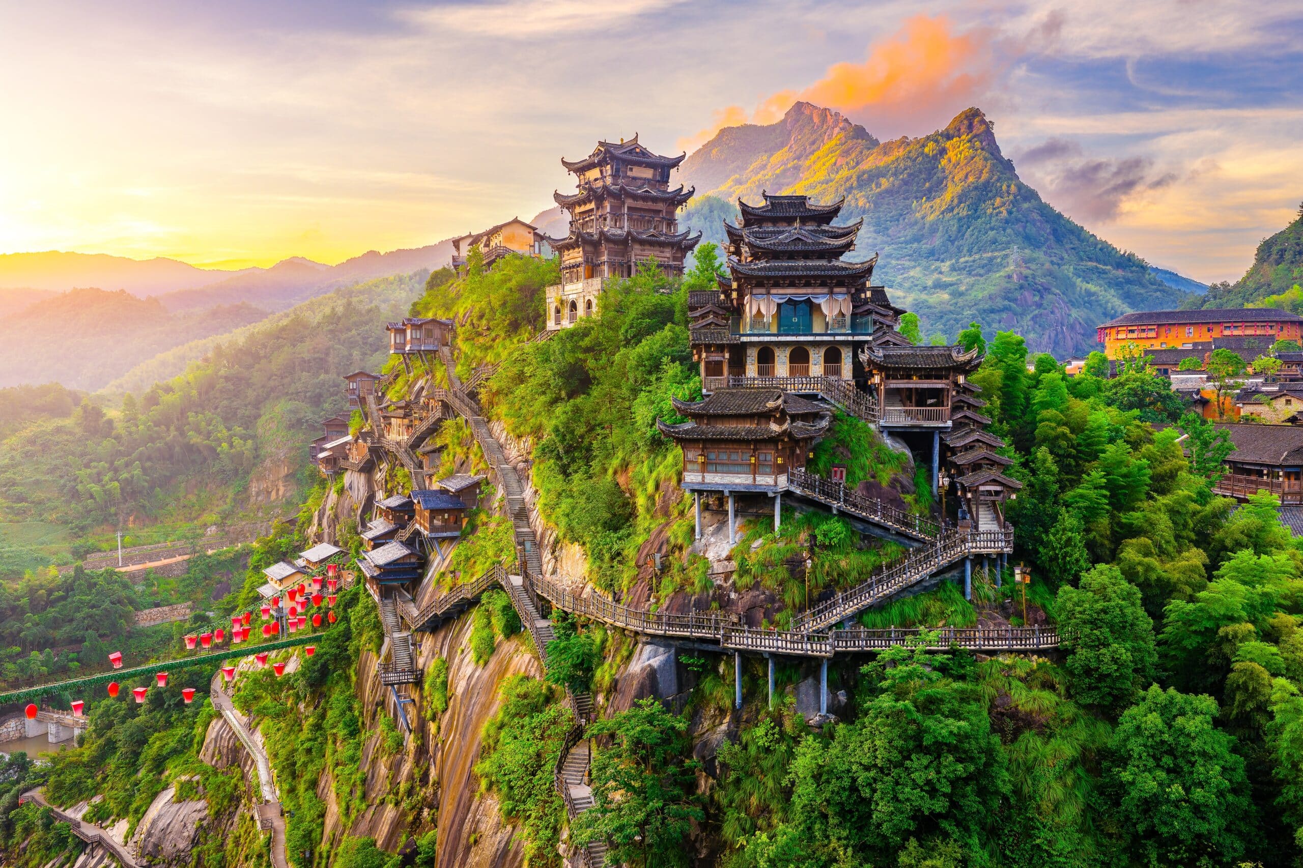
5. Mount Huangshan
Mount Huangshan is located in eastern China’s Anhui Province. Geography here is granite mountain terrain shaped by tectonic uplift and long-term erosion.
The range consists of steep granite peaks rising sharply above surrounding lowlands. Over millions of years, weathering fractured the rock into dramatic spires and rounded summits.
The mountains were uplifted during Mesozoic tectonic activity and later sculpted by wind, rain, and freeze-thaw cycles. Ancient glaciers also contributed to shaping certain valleys and rock faces.
Vegetation varies with elevation, from subtropical forest at lower slopes to hardy pine trees clinging to exposed granite ridges. Cloud cover frequently drifts among peaks due to humid monsoon air rising from the plains.
The climate is humid subtropical at lower elevations, becoming cooler at higher altitudes. Rainfall is abundant during the summer monsoon.
Endurance here is erosional and climatic. Granite stability and forest preservation are vital to protecting fragile mountain ecosystems.
Mount Huangshan reflects eastern China’s mountain geography — uplifted, mist-covered, and granite-sculpted. Visitors encounter sharp peaks rising above seas of clouds that illustrate the slow geological transformation of solid rock into dramatic alpine forms.
4. Kashgar
Kashgar lies in far western China near the edge of the Tarim Basin. Geography here is desert oasis framed by some of Asia’s highest mountain ranges.
The city sits at the western margin of the Taklamakan Desert, where limited rivers descending from the Pamir and Kunlun Mountains create pockets of irrigated land.
Surrounding terrain includes vast sand dunes, gravel plains, and snow-capped peaks. The Tianshan and Kunlun mountain systems influence regional climate and water supply.
The climate is arid continental, with hot summers, cold winters, and minimal annual rainfall. Snowmelt from surrounding mountains is essential for agriculture and settlement.
Geologically, the Tarim Basin formed through tectonic compression between continental plates. Thick sediment layers accumulated over millions of years in this inland depression.
Endurance here is hydrological and climatic. Oasis irrigation and water conservation are central to survival in this desert environment.
Kashgar reflects western China’s basin-and-mountain geography — arid, high-contrast, and mountain-fed. Visitors encounter stark desert expanses beneath towering peaks that illustrate the environmental extremes of Central Asia.
3. Dalian
Dalian lies on the southern tip of the Liaodong Peninsula in northeastern China. Geography here is rocky peninsula extending into the Yellow Sea.
The city occupies coastal headlands and low hills composed largely of resistant crystalline rock. Wave action has shaped cliffs, coves, and sandy beaches along the shoreline.
Inland terrain consists of rolling hills descending toward the sea. The peninsula separates the Bohai Sea from the open Yellow Sea, influencing regional maritime conditions.
The climate is temperate maritime, with warm summers and cold but moderated winters compared to inland northeastern regions.
Geologically, the area rests on ancient bedrock that has withstood extensive marine erosion. Coastal processes continue to reshape shorelines over time.
Endurance here is coastal. Marine weather systems and shoreline stability influence long-term development.
Dalian reflects northeastern China’s maritime geography — peninsula-based, sea-exposed, and climatically moderated. Visitors encounter rocky shores and expansive ocean views that demonstrate the contrast between inland continental plains and China’s northern seacoast.
2. Tianjin
Tianjin is a major port city in northern China, located along the western coast of the Bohai Bay, approximately 120 kilometers southeast of Beijing. Its strategic position at the mouth of the Hai River has historically made it a critical hub for trade, transport, and cultural exchange.
Geographically, Tianjin occupies a flat alluvial plain formed by sediments carried from the surrounding mountains and the Hai River system. The city’s low-lying terrain, averaging only a few meters above sea level, has made it naturally suited for harbor construction, yet also vulnerable to flooding. Canals and river channels crisscross the urban area, reflecting centuries of hydrological management to control water flow and facilitate navigation.
Tianjin’s climate is classified as humid continental, influenced by monsoon winds. Summers are hot and humid, while winters are cold and dry. Seasonal storms, including occasional typhoons and heavy rainfall, affect the Bohai Bay coastline and require robust urban drainage and flood-control systems.
The city’s port connects northern China to the Bohai Sea, the Yellow Sea, and beyond, making Tianjin an economic gateway for industry, shipping, and logistics. Coastal and tidal processes have shaped mudflats and estuarine landscapes near the harbor, while human engineering has significantly altered the shoreline through reclamation and dock construction.
Geologically, the area rests on Quaternary alluvial deposits, with sandy and silty soils that influence construction and infrastructure planning. Continuous sediment deposition from the Hai River delta contributes to slow but ongoing landscape change along the coast.
Endurance here is coastal and hydrological. Urban planning, river management, and port engineering reflect Tianjin’s adaptation to flat, river-fed terrain under monsoonal and tidal forces.
Tianjin reflects northern China’s coastal plain geography — low-lying, river-influenced, and economically strategic. Visitors encounter a city where waterways, port infrastructure, and modern development intertwine with centuries of human adaptation to a dynamic flatland environment.
1. Great Wall of China
Great Wall of China stretches across northern China, winding over deserts, mountains, and plateaus for more than 21,000 kilometers. Geography here is deeply intertwined with topography: the wall was constructed to follow ridges, steep slopes, and strategic passes, taking advantage of natural terrain as a defensive barrier.
Sections of the Wall cross the Yan Mountains near Beijing, the rugged Hebei hills, and the arid expanses of the Gobi Desert. Builders used locally available materials: stone in mountainous areas, tamped earth in plains and deserts, and bricks near urban centers. This created a structure that mirrors the underlying geology.
The northern plateau and mountain regions where the Wall traverses experience a continental climate: hot summers, frigid winters, and limited precipitation in arid zones. Mountain ridges often experience sudden snow and fog, adding natural defense and making construction challenging.
The Great Wall’s alignment demonstrates careful use of topography. Watchtowers sit atop ridges or cliffs, while walls dip into valleys and re-emerge on the next elevation. This mirrors northern China’s mountainous and desert geography, where strategic observation and troop movement relied on the natural landscape.
Geologically, much of the Wall follows granitic and sedimentary ridges uplifted by tectonic processes. Erosion and seasonal temperature shifts have shaped both the Wall and the terrain over centuries, requiring ongoing restoration in many sections.
Endurance here is both human and natural. The Wall showcases adaptation to topography and climate while enduring centuries of weathering.
The Great Wall of China reflects northern China’s mountain-and-desert geography — ridge-following, strategically elevated, and visually integrated with the land. Visitors encounter towering stone and earthen barriers that reveal the inseparable link between human engineering and the formidable geography of northern China.