
Iran occupies a vast portion of the Iranian Plateau in Western Asia, bordered by the Caspian Sea to the north and the Persian Gulf and Gulf of Oman to the south. Geography defines the country through dramatic contrasts between high mountain chains, arid deserts, fertile basins, and long maritime coastlines.
The Alborz Mountains rise along the southern shore of the Caspian Sea. Geography reinforces a sharp climatic divide between humid northern forests and the dry interior plateau.
The Zagros Mountains stretch diagonally from northwest to southeast. Geography binds tectonic uplift to seismic activity and complex river systems.
Between these mountain ranges lie expansive desert basins, including the Dasht-e Kavir and Dasht-e Lut. Geography emphasizes hyper-arid conditions shaped by continental climate and limited precipitation.
Major rivers such as the Karun flow through southwestern lowlands. Geography requires irrigation systems to sustain agriculture in semi-arid environments.
Iran’s southern coastline meets warm inland seas. Geography highlights strategic maritime corridors shaped by tectonic and sedimentary processes.
Iran inspires through sweeping landscapes that range from snow-capped summits to vast salt flats and subtropical coastal plains. The land teaches endurance through adaptation to seismic forces, water scarcity, and climatic extremes, showing how resilience develops where mountain barriers enclose desert interiors.
Endurance here is geological and hydrological. Geography requires watershed protection in upland regions and sustainable water management across plateau basins. Stability depends on balancing fragile desert ecosystems with agricultural and urban expansion.
Iran reflects a civilization shaped by plateau geography, tectonic complexity, and climatic contrasts. Visitors encounter a country where resilience emerges from coexistence between mountains, deserts, forests, and seas.
24. Tehran
Tehran lies in northern Iran at the southern foothills of the Alborz Mountains. Geography here is transitional between rugged alpine slopes and the semi-arid plains of the central plateau.
The Alborz range forms a dramatic northern backdrop. Geography reinforces cooler microclimates at higher elevations and snow-fed seasonal runoff.
Southward, terrain descends into flat steppe plains. Geography binds urban expansion to limited groundwater resources.
Tehran sits within a seismically active zone. Geography requires earthquake-resistant infrastructure due to tectonic interaction between the Arabian and Eurasian plates.
Rivers descending from the mountains historically supplied water through qanats and reservoirs. Geography emphasizes dependence on upland snowmelt.
Tehran inspires through its striking juxtaposition of mountain ridges and vast plateau horizons. The land teaches endurance through adaptation to seismic risk, air inversion layers, and water scarcity, showing how resilience develops where major urban systems meet natural constraints.
Endurance here is climatic and geological. Geography requires integrated water management and slope stabilization along mountain fronts. Stability depends on preserving upstream watersheds that regulate runoff into the capital region.
Tehran reflects Iran’s northern plateau geography shaped by mountain uplift and arid basin expansion. Visitors encounter a landscape where resilience emerges from coexistence between alpine ridges and densely populated plains.
23. Isfahan
Isfahan lies in central Iran along the Zayandeh River within a broad alluvial plain framed by distant mountain ranges. Geography here is riverine lowland shaped by seasonal flows and fertile soils that historically supported settlement and agriculture.
The Zayandeh River crosses the city from west to east. Geography reinforces Isfahan’s role as a regional hub, providing water for irrigation and urban use in an otherwise semi-arid interior.
Flat plains extend across the surrounding landscape. Geography binds settlement and transport networks to drainage corridors that drain toward the central basin. Hills and low mountains rise beyond the floodplain. Geography requires adaptation to limited rainfall and seasonal river variability typical of Iran’s plateau climate.
Isfahan’s historic core clusters near river terraces, where fertile ground supported gardens and orchards. Geography influenced early civilization patterns and remains visible in the layout of bridges and bridges crossing the Zayandeh.
The river also moderates summer heat. Geography teaches endurance through adaptation to seasonal climatic variation, showing how resilience develops where dense settlement depends on controlled water use in a dry interior.
Endurance here is hydrological and agricultural. Geography requires advanced water management, including qanat systems and river regulation. Stability depends on preserving upstream watersheds to sustain irrigation and urban supply.
Isfahan reflects Iran’s central plateau geography shaped by river basins and inland climatic extremes. Visitors encounter a landscape where resilience emerges from coexistence between water corridors and broad lowland plains.
22. Shiraz
Shiraz lies in the southwest of Iran on a gentle plain near the Zagros Mountains and close to the arid interior plateau. Geography here is transitional between fertile basins and dry highlands, enriched by runoff from surrounding mountains.
The surrounding terrain slopes gradually toward the central plateau, with the Zagros forming a backdrop to the northwest. Geography reinforces fertile soils near seasonal streams descending from uplands.
Shiraz lies within a region where mountain-fed water supports abundant gardens and vineyards. Geography binds settlement to water-rich terraces and mild microclimates compared with harsher desert interiors.
The city’s climate is semi-arid with wetter winters than much of central Iran. Geography requires adaptation to seasonal rainfall patterns but allows agricultural flourishing where water is available.
Shiraz inspires through its contrast between lush gardens and surrounding dry plains. The land teaches endurance through centuries of adapting settlement, agriculture, and culture to seasonal water availability shaped by mountain runoff.
Endurance here is hydrological and ecological. Geography requires sustained management of irrigation and protection of fertile basins against desert encroachment. Stability depends on channels directing highland flow into cultivated lands.
Shiraz reflects Iran’s southwestern geography shaped by foothill basins and Zagros influence. Visitors encounter a landscape where resilience emerges from coexistence between irrigated plains and surrounding uplands.
21. Persepolis
Persepolis lies in the Fars Province near Shiraz on a gentle plateau at the foot of the Zagros Mountains. Geography here is upland basin terrain shaped by river-fed gullies and fertile soils that once sustained ancient agricultural production.
The site sits above surrounding plains where seasonal streams descend from the Zagros foothills. Geography reinforces the strategic choice of elevated ground that overlooked fertile valley floors.
Rolling hills rise to the north and west. Geography binds this landscape to runoff contributing to seasonal water availability and soil formation.
The climate is continental with hot, dry summers and cooler, wetter winters. Geography requires adaptation to long dry spells and seasonal river flows.
Persepolis inspires through its dramatic elevation and ancient stone architecture set against broad valley plains. The land teaches endurance through historical adaptation to semi-arid conditions, showing how sophisticated urban centers once managed water, agriculture, and construction in an interior environment.
Endurance here is geological and historical. Geography requires careful water use and protection of ancient earthworks from erosion. Stability depends on preserving both the ruins and the natural terrain that supports them.
Persepolis reflects Iran’s plateau geography shaped by upland basins near tectonic mountain belts. Visitors encounter a landscape where resilience emerges from coexistence between ancient cultural achievements and enduring natural constraints.
20. Mount Damavand
Mount Damavand rises as the highest peak in Iran and the tallest volcano in Asia, standing at about 5,610 meters in the Alborz mountain range north of Tehran. Geography here is high alpine and volcanic, shaped by tectonic uplift along the boundary between the Arabian and Eurasian plates and long-term glacial erosion.
The mountain dominates the skyline of northern Iran. Geography reinforces sharp elevation gradients, with steep slopes that trap snow and form permanent snowfields near the summit. Seasonal meltwater feeds streams that descend into surrounding valleys. Geography binds surface water to upland runoff that sustains foothill ecosystems and human settlement.
The climate transitions dramatically from base to peak. Lower slopes experience temperate, wetter conditions, while upper zones are subject to harsh alpine weather with heavy snow and strong winds. Geography requires adaptation to altitude and weather extremes.
Trails and routes up Damavand follow natural ridges and glacial paths. Geography emphasizes vertical movement through zoned ecosystems — from mountain forest at lower elevations to barren alpine rock near the summit.
Mount Damavand inspires through sheer presence and its symbolic role in Persian mythology and identity. The land teaches endurance through adaptation to altitude and climatic adversity, showing how resilience develops where tectonic forces build towering relief against a backdrop of inland plateau.
Endurance here is geological and climatic. Geography requires careful route planning, snow and avalanche awareness, and protection of fragile alpine environments. Stability depends on preserving headwater sources and managing human impact on sensitive high-elevation zones.
Mount Damavand reflects Iran’s complex tectonic and alpine geography, shaped by mountain building and climatic extremes. Visitors encounter a rugged landscape where resilience emerges from coexistence between glacial peaks and plateau drainage systems.
19. Rasht
Rasht lies in northern Iran near the Caspian Sea coast and serves as the capital of Gilan province. Geography here is coastal lowland shaped by a humid subtropical climate with abundant rainfall and proximity to both sea and mountain.
The city is nestled between the Caspian shoreline and the forested foothills of the Alborz Mountains. Geography reinforces a landscape of lush plains, extensive rice paddies, and broad water networks that flow down from the uplands.
The region’s high precipitation supports temperate rainforests to the south of Rasht and thick vegetation that contrasts sharply with Iran’s otherwise arid interior. Geography requires adaptation to abundant moisture and wet soils.
Rivers and streams thread through the coastal plain before reaching the Caspian. Geography emphasizes drainage pathways that regulate flood cycles and sustain agricultural productivity.
Rasht inspires through its vibrant, rain-soaked environment and role as a connective hub between the sea and inland Iran. The land teaches endurance through adaptation to humidity and abundant water, showing how resilience develops where coastal and mountain influences intersect.
Endurance here is climatic and hydrological. Geography requires careful water management and preservation of wetlands. Stability depends on balancing urban expansion with protection of fertile plains and river corridors.
Rasht reflects Iran’s Caspian lowland geography, shaped by maritime influence and orographic rainfall from the nearby Alborz. Visitors encounter a landscape where resilience emerges from coexistence between temperate forests, coastal humidity, and agricultural plains.
18. Aras Geopark
Aras Geopark lies in northwestern Iran’s East Azerbaijan province along the Aras River valley near the border with Armenia and Azerbaijan. Geography here is diverse and geologically rich, spanning badlands, sandstone cliffs, volcanic outcrops, and deep riverine terrain.
Awarded UNESCO Global Geopark status in 2023, the region covers roughly 1,670 km² and preserves ancient geological history, including clues to the Permian-Triassic extinction event.
The Aras River forms part of the northern boundary, carving out deep valleys and badland formations in its wake. Geography binds water-shaped erosion to dramatic landscapes of layered rock, shifting sediments, and terraces.
Uplands in the geopark consist of Tudor and Cretaceous rock types, with volcanic and granitic structures underlying parts of the terrain. Geography emphasizes variation in lithology caused by historical tectonic activity and sedimentation.
The climate here can vary with elevation — from river valleys that moderate temperatures to higher slopes with cooler conditions. Geography requires adaptation to contrasts between sheltered lowland corridors and exposed upland ridges that funnel winds and rainfall.
Aras Geopark inspires through its textured earthforms and paleogeological significance. The land teaches endurance through adaptation to eons of tectonic shift and erosional forces, showing how resilience develops where rivers carve landforms and rock records reveal deep time.
Endurance here is geological and hydrological. Geography requires careful conservation of fragile rock exposures, sediment pathways, and riverbank ecosystems. Stability depends on preserving both earth heritage and living ecosystems that thrive amid shifting geology.
Aras Geopark reflects Iran’s Caucasus foothill geography shaped by tectonic uplift, river incision, and sediment redistribution. Visitors encounter a landscape where resilience emerges from coexistence between ancient rock records and dynamic river systems.
17. Maranjab Desert
Maranjab Desert lies in central Iran within the northern reaches of the Aran and Bidgol County, forming part of the greater Dasht-e Kavir (Great Salt Desert). Geography here is hyper-arid desert shaped by sand dunes, salt pans, and occasional shallow wetlands that appear after rare rains.
The terrain varies from towering sand dunes to broad salt flats. Geography reinforces minimal vegetation and sparse settlement due to extremely dry conditions and high evaporation rates.
Key dune fields can rise up to 70 meters above the plain, sculpted by persistent winds that sweep across the central plateau. Geography binds landforms to wind-driven erosion and deposition, creating a dynamic surface that shifts with seasonal weather patterns.
In the north, Mesileh Salt Lake appears during wetter periods, forming shallow brine pools that reflect sunlight across flat expanses. Geography requires adaptation to seasonal change and near-constant dry conditions outside brief rainfall windows.
Despite its warning appearance, the Maranjab Desert supports salt-tolerant vegetation and specialized wildlife adapted to life on the edge of habitable land. Freshwater wells and traditional qanat water systems historically sustained travelers and oases settlements long before modern drilling.
Maranjab inspires through its vast open horizons and interplay between sand, salt, and sky. The land teaches endurance through adaptation to arid extremes, showing how resilience develops where climatic and geographic constraints supersede most seasonal growth.
Endurance here is climatic and geomorphological. Geography requires careful management of water resources and sensitive desert ecosystems threatened by off-road disturbance. Stability depends on maintaining fragile dune and salt flat landscapes within this central Iranian plateau environment.
Maranjab Desert reflects Iran’s interior basin geography shaped by wind, salt, and scarce water — a place where natural processes dominate human presence.
16. Shirez Canyon
Shirez Canyon lies in western Iran’s Lorestan Province near Kuhdasht, carved by tributaries of the Karkhen River through ancient sedimentary rock layers in the Zagros Mountains. Geography here is dramatic river valley and canyon terrain shaped by long-term erosion.
The canyon walls rise steeply from the valley floor. Geography reinforces variations in rock hardness and structural composition that guide stream erosion into deep gorges over geologic time.
Springs near the headwaters feed the Seimare tributary, which flows into the larger Karkhen River system. Geography binds water flow to downstream drainage patterns that distribute sediment across interior lowlands.
Sedimentary rocks, often belonging to ancient Devonian formations, create unique layered cliff faces visible throughout the canyon. Geography requires adaptation to rugged terrain and limited flat land, preserving remote and dramatic natural corridors.
The canyon’s geology reveals ancient erosion patterns that attract geotourism interest, linking deep river valleys with broader limestone ridges across the Zagros range. Geography emphasizes steep relief and contrasting elevation between narrow valley floors and surrounding highlands.
Shirez Canyon inspires through its rugged vistas and geological heritage. The land teaches endurance through adaptation to tectonic uplift and persistent erosive forces, showing how resilience develops where rivers patiently sculpt bedrock.
Endurance here is geological and hydrological. Geography requires protection of canyon ecosystems, careful trail planning, and preservation of fragile cliff environments. Stability depends on regulating access to minimize erosion and human impact.
Shirez Canyon reflects Iran’s Zagros highland geography shaped by mountain uplift and fluvial sculpting, inviting visitors to witness a landscape where water and rock interplay across seismic terrain.
15. Qeshm Island
Qeshm Island lies in the Persian Gulf off Iran’s southern coast, forming part of a UNESCO-listed Global Geopark known for its unique geological and ecological features. Geography here is insular and marine, shaped by tectonic subsidence, sedimentary rock, and tidal processes that define narrow channels and intricate coastal formations.
The island’s northern shorelines host Hara Mangrove forests, thriving where saline waters and land meet. Geography reinforces rich biodiversity in tidal wetlands that support birds and marine life uncommon in Iran’s drier interior.
Further inland, Chahkooh Canyon winds through smooth rock formations carved by erosion. The canyon’s narrow gorges and sculpted walls show how persistent water and wind shape limestone over eons.
Star Valley presents surreal earthworks where wind has etched patterns across soft sedimentary beds. Geography here demonstrates aeolian processes acting on broadly exposed plains within the island’s core.
The island’s southern coastlines overlook deep Persian Gulf waters. Geography binds ocean currents, tidal regimes, and marine influences to island shaping and habitat distribution.
Qeshm inspires through its diversity — from mangrove waterways and riparian greens to stark canyons and smooth wind-polished stone. The land teaches endurance through adaptation to land-sea gradients, showing how resilience develops where water, wind, and sediment converge.
Endurance here is ecological and geomorphological. Geography requires protection of mangrove ecosystems, erosion-prone rock formations, and marine channels. Stability depends on preserving both tidal wetlands and inland landscapes shaped by Persian Gulf influence.
Qeshm Island reflects Iran’s Persian Gulf geography shaped by sedimentation, tidal flow, and climatic variation — a place where rugged beauty and dynamic systems coexist.
14. Hormuz Island
Hormuz Island lies in the Persian Gulf off Iran’s southern coast near the strategic Strait of Hormuz. Geography here is marine-insular and arid, shaped by ancient salt deposits, volcanic sediments, and tidal currents that sculpt rugged shorelines and colorful landforms.
The island’s terrain is flat to gently rolling, rising only modestly inland. Geography reinforces exposure to dry winds and strong sunlight, resulting in sparse vegetation and stark landscapes.
Hormuz is famed for its red beach and vibrant soils rich in iron oxide. These mineral-stained surfaces create dramatic visual contrast against blue Persian Gulf waters. After rare rainfall, runoff channels iron-rich sediment toward the sea, briefly coloring the shoreline and coastal waters crimson — a phenomenon that attracts photographers and visitors alike.
Shallow coastal waters, coral outcrops, and salt flats define much of the island’s marine environment. Geography binds tidal flux to marine life adapted to warm, saline conditions.
Despite its arid interior, narrow coastal plains support small villages where fishing and date farming occur. Geography requires adaptation to limited freshwater resources, traditionally drawn from local wells and tents of wind-baked stone.
Hormuz inspires through its rugged beauty and unusual coloration that mirror ancient geologic processes. The land teaches endurance through adaptation to wind, salt, and sea, showing how resilience develops where island systems contend with harsh desert and marine influences.
Endurance here is climatic and geological. Geography requires shoreline protection and management of fragile ecosystems. Stability depends on maintaining natural sediment flows and limiting erosion in an environment where marine and terrestrial forces meet.
Hormuz Island reflects Iran’s maritime geography shaped by Persian Gulf currents and sedimentary rock. Visitors encounter a landscape where rugged color and coastal exposure embody the meeting of earth and sea.
13. Anzali Lagoon
Anzali Lagoon lies on the Caspian Sea coast in northern Iran near Bandar-e Anzali. Geography here is coastal wetland and brackish lagoon system shaped by lowland rivers, tidal exchange, and sediment deposition.
The lagoon occupies an expansive coastal basin, receiving inflow from multiple rivers and streams that drain the inland Gilan plain into the Caspian Sea. Geography reinforces an environment of freshwater and brackish zones where complex wetland ecosystems flourish.
Shallow waters intermix with marshes and reed beds. Geography binds aquatic and terrestrial habitats, supporting rich biodiversity, including migratory waterbirds and resident fish species.
The Caspian Sea’s tidal influence extends into the lagoon, creating seasonal fluctuations in water levels. Geography requires adaptation to sedimentation and shifting salinity influenced by seasonal rainfall and river discharge.
The surrounding region’s humid subtropical climate produces abundant rainfall relative to Iran’s interior plateaus. Geography reinforces lush coastal plains that contrast sharply with dry central landscapes.
Anzali Lagoon inspires through its peaceful expanses of reed and water, punctuated by calls of migratory birds and the tranquil rhythm of shallow tides. The land teaches endurance through adaptation to variable hydrological conditions, showing how resilience develops where freshwater meets sea, and wetland ecosystems sustain seasonal life cycles.
Endurance here is ecological and hydrological. Geography requires careful management of sediment flow and protection of fragile wetlands from pollution and siltation. Stability depends on balancing upstream watershed health with the lagoon’s ecological integrity.
Anzali Lagoon reflects Iran’s Caspian lowland geography shaped by coastal plains, river networks, and tidal dynamics. Visitors encounter a landscape where resilience emerges from coexistence between water, wetland vegetation, and migratory species.
12. Hyrcanian Forests
Hyrcanian Forests stretch along the southern Caspian Sea coast in northern Iran, forming an ancient band of temperate broadleaf forest recognized as a UNESCO World Heritage Site. These forests represent one of the world’s oldest ecological systems, dating back tens of millions of years.
The geography of the Hyrcanian region is defined by a humid subtropical coastal plain rising abruptly into the foothills of the Alborz Mountains. Moisture-laden winds from the Caspian Sea collide with rising terrain, producing heavy rainfall that sustains dense forest cover.
Ancient trees, including beech, oak, and hornbeam species, form multi-layered canopies. Geography binds biodiversity to a climate seldom found in Iran’s otherwise dry profile, supporting mammals, birds, and unique plant communities.
Rivers and streams descend rapidly from the Alborz into the coastal plain, carving gorge systems through forested slopes. Geography requires adaptation to steep gradients and periodic flood flows after intense rainfall events.
Humid conditions influence soil richness and undergrowth, contrasting sharply with interior plateau desert zones. Geography emphasizes transition from lush, wet Caspian coast landscapes to arid central basins.
The Hyrcanian Forests inspire through their ancient continuity and ecological richness. The land teaches endurance through adaptation to long-term climatic stability that preserved these forests through glacial and interglacial cycles, showing how resilience develops where consistent moisture and complex topography meet.
Endurance here is ecological and climatic. Geography requires protection of watersheds and forest habitats against deforestation and fragmentation. Stability depends on preserving this rare temperate ecosystem that buffers inland climate and sustains regional biodiversity.
The Hyrcanian Forests reflect Iran’s northern Caspian geography shaped by marine influence and mountain uplift. Visitors encounter a landscape where resilience emerges from coexistence between ancient woodlands and coastal hills.
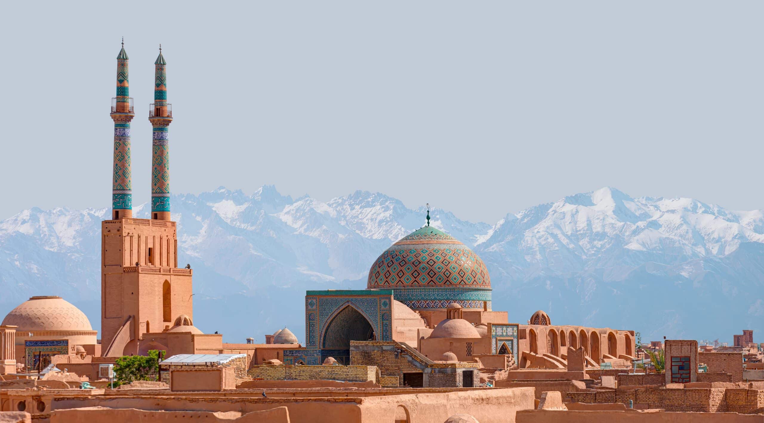
11. Historic City of Yazd
Yazd lies in central Iran on the edge of the Dasht-e Kavir desert, occupying a flat plateau within one of the driest parts of the Iranian Plateau. Geography here is arid desert basin shaped by minimal rainfall, extreme summer heat, and an ancient network of underground water systems. Yazd’s urban fabric is adapted to these harsh conditions through ingenious engineering and architectural forms that respond directly to geography.
The city’s location between two deserts makes water the defining geographic factor. The ancient system of qanats, subterranean aqueducts that channel water from distant uplands, enabled settlement in this otherwise inhospitable region. Buildings cluster around these life-giving watercourses.
Yazd is renowned for its mudbrick architecture, developed as a response to the hot, dry climate. Narrow alleys and thick earthen walls shade streets and regulate interior temperatures. The skyline is punctuated by tall windcatchers (badgirs), passive cooling towers designed to funnel breezes into homes — a direct geographic adaptation to intense heat and wind.
Within the city fabric, you’ll find Dowlatabad Garden — a UNESCO-listed Persian garden and demonstration of human ingenuity in managing desert water through qanat irrigation, cool shade, and geometrically designed spaces that contrast sharply with the surrounding plaza plains.
Yazd inspires through its seamless blend of urban planning and environmental adaptation. The land teaches endurance through centuries of community innovation where settlement stubbornly persists on the periphery of the desert, shaping architecture, water management, and daily life around geographic constraints.
Endurance here is climatic and hydrological. Geography demands ongoing water conservation, preservation of traditional qanat networks, and protection of historic adobe structures. Stability depends on balancing modern growth with conservation of ancient responses to desert life.
Yazd reflects Iran’s plateau desert geography shaped by harsh climate, water scarcity, and cultural ingenuity — a landscape where resilience emerges from coexistence with inhospitable surroundings.
10. Fin Garden (Kashan)
Fin Garden lies in the oasis city of Kashan on the northern edge of the Iranian Plateau in central Iran. Geography here is semi-arid plain shaped by desert basins, saline soils, and isolated fertile pockets supported by underground water systems.
The inland plain extends broadly from Tehran toward Yazd, broken only by isolated limestone hills. Geography reinforces scarcity of surface water and dependence on subterranean sources for agriculture and urban life. Within that context, Fin Garden stands out as a brilliant adaptation to local conditions. It using carefully engineered qanat water channels to bring cool, clear water deep into the heart of the estate.
Fin Garden’s formal layout — water channels, pools, orchards, and shaded pavilions — demonstrates how geography informed traditional Persian design philosophy. The smooth flow of water through the dry plains symbolizes life amid aridity. Its shaded corridors and geometric symmetry respond directly to the challenge of intense sun and limited rainfall.
The garden’s centerpiece is its interplay between water and desert terrain. Pools reflect light and cool surrounding air, while tall shade trees create micro-climates in a region otherwise defined by heat and dryness. Surrounding buildings and garden walls maintain a cooler environment through masonry mass and carefully oriented openings.
Fin Garden inspires through this elegant balance. The land teaches endurance through adaptation to climatic extremes, showing how geography can shape cultural response and architectural innovation even where conditions are difficult.
Endurance here is climatic and hydrological. Geography requires advanced water management — both engineering and horticultural — to sustain lush gardens within a desert setting. Stability depends on preserving qanat systems and teaching future generations about the ancient balance between water, shade, and settlement.
Fin Garden reflects Iran’s interior plateau geography shaped by desert plains and subterranean water networks, revealing how human ingenuity can cultivate paradise in austere landscapes.
9. Gonbad-e Qābus
Gonbad-e Qabus Tower stands in northern Iran’s Golestan province near the city of Gonbad-e Kavus, situated on the broad lowlands of the southeastern Caspian plain. Geography here is flat and fertile, shaped by river systems draining from the Alborz Mountains into the Caspian Sea basin.
The plain’s gentle relief facilitated early settlement and agriculture, leading to cultural development over centuries. Geography reinforced ease of travel and transport across productive lowland fields, contributing to the region’s historic importance as a crossroads of commerce and culture.
Gonbad-e Qābus Tower itself rises dramatically above the surrounding plain. Built in the early 11th century, this brick tomb tower soars over 50 meters. Its vertical geometry makes it a standout landmark, designed to be visible from afar across the open land.
The structure embodies early Islamic and Central Asian architectural influences, blending robust brick technology with symbolic geometry. Geography here plays both practical and symbolic roles — the tower’s prominence offers a visual compass for travelers across flat terrain, guiding movement in an environment where natural landmarks are sparse.
The region’s climate is temperate and relatively moist due to Caspian influence, in contrast to Iran’s interior deserts. Geography requires adaptation to lush plains and seasonal rainfall, supporting grain cultivation and irrigation.
Gonbad-e Qābus inspires through its elegant form rising over fertile fields. The land teaches endurance through adaptation to both cultural innovation and geographic openness, showing how resilience develops where architectural achievement interacts with wide, flat landscapes.
Endurance here is climatic and geological. Geography requires balanced agricultural practices and protection of historic fabric from seasonal shifts in moisture and temperature. Stability depends on preserving this monumental testament to human ingenuity in a landscape of open fields and distant horizons.
Gonbad-e Qābus reflects Iran’s northern Caspian plain geography, shaped by river sedimentation and cultural exchange across fertile terrain.
8. Saint Stepanos Monastery
Saint Stepanos Monastery lies in northwestern Iran along the Aras River valley near the border with Armenia and Azerbaijan. Geography here is riverine and mountainous, dominated by rugged hills carved by centuries of fluvial incision.
The Aras River forms a natural corridor through the foothills of the Lesser Caucasus, creating deep valleys that guide settlement and transport corridors. Geography reinforces the monastery’s position within lush, green river valleys that contrast sharply with Iran’s typically arid interior.
The surrounding terrain is composed of steep slopes and rocky ridges. Geography binds the historic complex to an environment where water and stone converge, shaping an ancient landscape of biodiversity and geological complexity. Seasonal flood flows and rainfall runoff influence vegetation patterns, requiring adaptation to both moisture and slope stability.
Built originally in the ninth century and later rebuilt in the Safavid era, Saint Stepanos reflects centuries of architectural response to rugged terrain and dynamic hydrology. The deep valley walls provide natural protection, while the calm river setting underscores the region’s agricultural potential through sustained water supply.
The monastery inspires through its dramatic siting — stone structures nestled amid verdant canyon walls that echo broader Caucasus landscapes. The land teaches endurance through adaptation to a valley shaped by tectonic uplift and persistent erosion, showing how resilience develops where sacred sites meet natural waterways. Endurance here is hydrological and geological, with geography requiring measures to protect riverbanks and preserve hillside vegetation that regulates water flow and prevents dangerous landslides.
Stability depends on balancing conservation of cultural heritage with watershed management. Saint Stepanos Monastery reflects Iran’s northwest borderland geography shaped by river valleys, mountain ridges, and international frontiers. Visitors encounter a landscape where resilience emerges from coexistence between flowing water, steep relief, and centuries-old human craftsmanship.
7. Shushtar Historical Hydraulic System
Shushtar Historical Hydraulic System lies in southwestern Iran amid the fertile plains carved by the mighty Karun River. Geography here is riverine floodplain and engineered landscape shaped over millennia by human ingenuity and natural forces.
The Karun River flows southward from the Zagros Mountains, depositing rich alluvial soils that make this area among Iran’s most productive agricultural regions. The hydraulic system includes a network of dams, canals, tunnels, and watermills that were originally developed in antiquity and expanded during the Sassanian era.
Geography played a central role in the system’s development — the height gradient between river channels and surrounding plains allowed engineers to distribute water widely, irrigating tens of thousands of hectares. Ancient dams divert flow into canals that branch across floodplain lands, feeding farms and powering water mills.
Shushtar’s terrain is relatively low and flat, shaped by seasonal swelling and recession of river levels. Geography requires adaptation to both seasonal flooding and controlled water release to maintain agricultural irrigation and settlement safety.
The hydraulic system inspires through its scale and integration with the natural river environment. The land teaches endurance through adaptation to hydrological cycles, showing how human engineering amplified the productivity of river plains. Endurance here is hydrological and agricultural, with geography requiring careful balance between water distribution and flood management.
Stability depends on preserving both ancient infrastructure and the natural processes that supply water — from upstream rainfall on the Zagros slopes to downstream floodplain recharge. Shushtar Historical Hydraulic System reflects Iran’s floodplain geography shaped by major river systems and long-term adaptation. Visitors encounter a landscape where resilience emerges from coexistence between engineered waterways and fertile plains.
6. Complex of Izadkhast
Complex of Izadkhast lies near the city of Izadkhast in south-central Iran’s Fars Province. Geography here is semi-arid valley and plateau terrain shaped by the broad Zagros foothills and expansive interior plains.
The complex consists of Izad-Khast Castle, an ancient settlement perched on a singular high bedrock overlooking a natural valley, along with a caravanserai and Safavid-era bridge. The plateau around Izadkhast extends into a deep valley carved over geological time by seasonal streams that feed toward larger drainage basins. Geography binds settlement to elevated rock that offers natural defense in otherwise open terrain.
Surrounding plains are dotted with rocky fields and scattered hills. Geography emphasizes the contrast between hard bedrock outcrops and softer arid soils that support limited vegetation. The broader region experiences semi-arid climatic conditions typical of central Iran’s interior, requiring adaptation to variable rainfall, hot summers, and cold winters.
The castle was strategically built against natural bedrock ridges that rise above a trench-like valley. Geography influenced the site’s defensibility and spatial organization, with walls and waterways positioned to enhance protection.
The adjacent caravanserai, part of historic trade routes, speaks to the region’s role as an inland crossroads where merchants traversed between Iranian cities and beyond. Geography here shaped ancient commerce — broad plains and plateaus offered navigable corridors between mountain passes.
The complex inspires through the interplay of natural bedrock and human architecture. The land teaches endurance through adaptation to rugged geography and climatic extremes, showing how communities rooted in valley and plateau landscapes devised defensive and logistical innovations.
Endurance here is geological and military. Geography requires both careful erosion control and preservation of historical structures. Stability depends on protecting the delicate balance between rock outcrops, valley floors, and the infrastructural heritage that anchors them.
5. Bam and Its Cultural Landscape
Bam and Its Cultural Landscape lies in southeastern Iran’s vast desert basin in Kerman Province. Geography here is arid, marked by sweeping plains of the central Iranian plateau bordered by distant mountain ridges. The region has sustained settlement through sophisticated water management systems that harness scarce groundwater in an otherwise unforgiving climate.
At the heart of the landscape stands Arg-e Bam, the largest adobe citadel ever constructed. Its towering walls rise from flat desert terrain, shaped from sun-dried mud bricks that mirror the earth’s ochre tones. Geography reinforces the citadel’s prominence on the open plain, where its height and scale made it a natural defensive stronghold and a symbol of regional power in antiquity.
The surrounding cultural landscape reflects centuries of human adaptation to arid conditions. Ingenious qanat systems — underground aqueducts that tap hillside aquifers — provided reliable water to fortifications, gardens, and towns that would otherwise not survive. Geography here binds life to subterranean water flow, reminding visitors that survival across Iran’s interior plateau depends on disciplined management of limited freshwater.
Seasonal rainfall patterns are minimal, and the land’s flatness amplifies heat and dry winds. Geography teaches endurance through adaptation to intense conditions, showing how irrigation, architecture, and settlement planning overcame the harsh climate. Endurance here is hydrological and architectural, requiring ongoing preservation of water channels and ancient structures that anchor community memory.
Bam and Its Cultural Landscape reflect Iran’s desert plateau geography shaped by heat, limited rainfall, and human resilience. Visitors encounter a landscape where survival strategies — underground water, fortified adobe, and oasis agriculture — forged a unique civilization bridging desert isolation and human ingenuity.
4. Tabriz Historic Bazaar Complex
Tabriz Historic Bazaar Complex lies within the broad Quru River basin of northwestern Iran, near the slopes of the Alborz and Zagros foothills and close to historic trade corridors linking Anatolia to the Iranian plateau. Geography here situates the bazaar at a natural crossroad of riverine plains and mountain routes that have guided human movement for millennia.
Expanded over centuries, the bazaar sprawls across brick-domed alleys, caravanserais, and mosques. Geography reinforces its role as the commercial heart of Tabriz, where merchants traded silk, spices, carpets, and metals between East and West. Its location near the Silk Road elevated the bazaar’s importance, as natural topography favored valley travel routes over rugged terrain.
The area’s mild climate and fertile soils — fed by seasonal runoff from nearby mountains — supported urban population growth and agricultural hinterlands that supplied goods to the bazaar’s markets. Geography required adaptation to local hydrology, using canals and drainage systems to moderate winter precipitation and summer heat.
The bazaar’s urban design responds directly to place: covered corridors protect traders and shoppers from climate extremes, while kerb-like corridors follow natural land contours. Geography helps shape the bazaar’s continuous connection between civic, religious, and economic spaces, reflecting how human settlement adapted to both riverine plains and nearby uplands.
Endurance here is cultural and economic, shaped by centuries of interaction with landscape and climate. The Tabriz Historic Bazaar Complex is a living testament to how geography guided trade, settlement, and architectural adaptation in northwestern Iran, where mountain passes meet fertile plains.
Visitors encounter a vibrant marketplace that remains active today, embodying centuries of resilience where commerce, culture, and geography converge along historic land and river pathways.
3. Takht-e Soleyman
Takht‑e Soleyman lies within a highland basin in northwestern Iran’s West Azerbaijan province, near the southern edge of the Caucasus foothills and part of ancient cultural landscapes associated with pre-Islamic empires. Geography here is dominated by an enclosed valley formed by rolling uplands and shallow lake basins at elevations over 1,300 meters above sea level.
At the heart of this landscape is Takht-e Soleyman (“Throne of Solomon”), a sacred archaeological complex with origins in the Sassanian era and layered religious meaning through millennia. The site sits beside Lake Goygol basin, surrounded by gentle hills that capture seasonal runoff and sustain grasslands amid an otherwise dry and cool highland climate.
The lake and surrounding marshes add hydrological richness to the basin, contrasting sharply with the arid steppes of Iran’s interior plateau. Geography binds ancient settlement to reliable freshwater sources and fertile floodplain soils moderated by mountain runoff.
The complex’s architecture reflects how ancient builders adapted religious and civic space to the sloped ground, using natural terraces and stonework that respect the uneven terrain. Geography plays into spatial organization — temples, pools, and walls nestle into hill shadows and open onto lake vistas.
Takht-e Soleyman’s history is inseparable from its surroundings. Endurance here is archaeological and spiritual, shaped by seasonal weather shifts, highland winters, and monsoon-fed summer days. The surrounding highland basin sustains grassland and woodland pockets, making it a biologically diverse corridor in an otherwise expansive plateau setting.
Takht-e Soleyman reflects Iran’s northwestern highland geography, shaped by ancient tectonics, seasonal runoff, and basin formation. Visitors encounter a landscape where natural and cultural history intersect — where lakes, uplands, and ancient architecture coexist in a testament to human adaptation to diverse terrain.
2. Chogha Zanbil
Chogha Zanbil lies in southwestern Iran’s Khuzestan Province on a broad alluvial plain formed by rivers descending from the Zagros Mountains toward the Persian Gulf. Geography here is lowland floodplain shaped by sediment deposition, seasonal river overflow, and fertile soils that have supported settlement since antiquity.
Built in the 13th century BCE by the Elamite civilization, Chogha Zanbil centers on a massive ziggurat rising above flat terrain. Its placement reflects the strategic advantages of open plains, where visibility across wide distances reinforced both religious symbolism and defensive awareness. The surrounding land, nourished by river systems such as the Dez and Karun, provided agricultural capacity that sustained ancient urban life.
The climate is hot and semi-arid, with extremely warm summers moderated slightly by winter rainfall. Geography required adaptation to both heat and periodic flooding. Ancient builders elevated sacred structures on high mud-brick platforms to protect them from erosion and water damage, demonstrating early engineering responses to floodplain dynamics.
The plain’s openness contrasts sharply with Iran’s mountainous and desert interiors. Here, water rather than elevation defines geography. Endurance is hydrological and agricultural, shaped by centuries of managing river flow and sediment accumulation.
Chogha Zanbil reflects Iran’s southwestern floodplain geography, where early civilizations flourished because of fertile soil and accessible water. Visitors encounter a landscape where monumental architecture rises from expansive plains, illustrating how human ingenuity adapted to riverine environments and transformed them into enduring cultural centers.
1. Lut Desert (Dasht-e Lut)
Dasht-e Lut stretches across southeastern Iran between Kerman and Sistan-Baluchestan provinces. Geography here is hyper-arid desert basin, shaped by extreme temperatures, salt flats, wind erosion, and tectonic uplift.
Recognized as a UNESCO World Heritage Site, the Lut Desert is among the hottest places recorded on Earth. Satellite measurements have detected some of the planet’s highest surface temperatures on its dark basalt plains. Geography reinforces climatic extremes: minimal rainfall, intense solar radiation, and strong seasonal winds sculpt the land into dramatic formations known as yardangs — elongated ridges carved by persistent wind erosion.
The desert floor alternates between gravel plains, sand seas, and salt-crusted flats. In the central sector, towering sand dunes rise more than 300 meters, among the tallest in the world. Surrounding mountain ranges block moist air masses, creating a profound rain shadow effect that intensifies aridity.
Despite its severity, the Lut Desert possesses stark beauty. The interplay of light and shadow across sculpted ridges produces shifting patterns that change with the sun’s angle. Geography here teaches endurance through adaptation to extremes — where life is sparse but geological processes are vividly exposed.
Endurance is climatic and geomorphological. Wind and heat continuously reshape the surface, making the landscape dynamic despite its apparent stillness. Stability depends on preserving this fragile environment from disturbance, as even minor impacts can persist for decades in such slow-recovering ecosystems.
Dasht-e Lut reflects Iran’s southeastern desert geography shaped by tectonics, solar intensity, and aeolian forces. Visitors encounter a landscape of profound scale and silence, where earth processes dominate and resilience is measured not in vegetation but in stone, sand, and time.