
Indonesia is the world’s largest archipelagic nation, stretching across more than 17,000 islands between the Indian and Pacific Oceans. Positioned along the equator, it forms a vast maritime bridge between mainland Southeast Asia and Australia, as well as between the Asian and Australian tectonic plates.
Geographically, Indonesia is defined by water. Major islands such as Sumatra, Java, Borneo (Kalimantan), Sulawesi, and Papua are separated by straits, seas, and deep ocean trenches. Maritime routes have historically shaped trade, migration, and cultural exchange across the archipelago.
Indonesia lies within the Pacific “Ring of Fire,” making it one of the most volcanically active regions on Earth. Over 120 active volcanoes rise across its islands, formed by tectonic subduction where the Indo-Australian Plate moves beneath the Eurasian Plate. This geological activity creates fertile soils that sustain dense agricultural populations, especially on Java and Bali.
The climate is tropical, with high humidity, consistent temperatures, and monsoon-driven rainfall patterns. Seasonal winds influence agriculture, fishing cycles, and transportation across islands.
Ecologically, Indonesia is one of the most biodiverse countries in the world. Rainforests, coral reefs, mangroves, and alpine highlands support extraordinary plant and animal life. The archipelago straddles the Wallace Line, a biogeographical boundary separating Asian and Australasian species.
Indonesia’s geography — volcanic, maritime, equatorial, and tectonic — has shaped settlement, agriculture, trade, and culture for millennia. In the chapters ahead, the country will be explored through its major island groups, volcanic landscapes, rainforest interiors, and coastal environments — revealing a nation inseparable from the forces of fire, water, and plate tectonics.
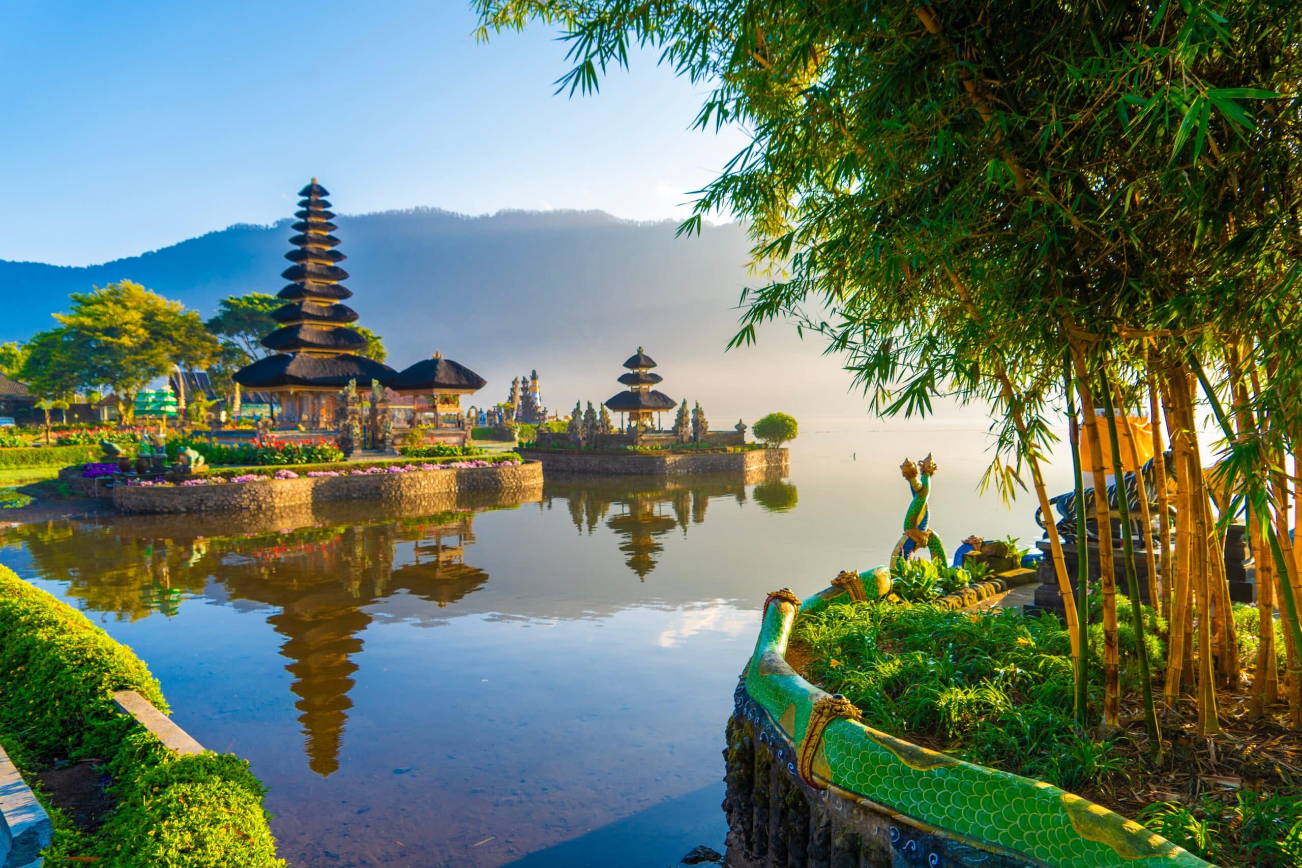
24. Bali
Bali is located between Java and Lombok in the Lesser Sunda Islands. Geography here is volcanic island terrain shaped by tectonic subduction and centuries of lava deposition.
The island is dominated by a central mountain spine, including Mount Agung, an active stratovolcano rising over 3,000 meters. These volcanic highlands create fertile soils that sustain terraced rice agriculture across slopes and valleys. The subak irrigation system distributes mountain water to lowland paddies, demonstrating adaptation to volcanic topography.
The coastline varies between sandy beaches in the south and rugged cliffs in the west and east. Coral reefs fringe parts of the shore, influenced by warm tropical currents of the Indonesian Throughflow connecting the Pacific and Indian Oceans.
The climate is tropical monsoon, with a wet season from November to March and a dry season from April to October. Elevation moderates temperatures in the central highlands compared to humid coastal zones.
Geologically, Bali lies along the Sunda Arc, where the Indo-Australian Plate subducts beneath the Eurasian Plate. Earthquakes and volcanic activity are ongoing geological realities.
Endurance here is volcanic and ecological. Agricultural productivity depends on fertile ash soils, while sustainable tourism must protect coastal reefs and upland forests.
Bali reflects Indonesia’s volcanic island geography — fertile, elevated, and ocean-bound. Visitors encounter terraced fields, black-sand beaches, and rising volcanic peaks that illustrate the powerful geological forces shaping the archipelago.
23. Jakarta
Jakarta lies on the northwest coast of Java along the Java Sea. Geography here is low-lying coastal plain formed by river sediment and influenced by tidal processes.
Thirteen rivers flow through the city, depositing silt across a flat deltaic landscape. Historically, these waterways enabled trade and agriculture, but urban expansion has increased flood vulnerability. Much of northern Jakarta sits at or below sea level, making it susceptible to tidal flooding and land subsidence.
The climate is equatorial tropical, with high humidity and heavy rainfall during the monsoon season. Seasonal storms strain drainage systems across the low-lying terrain.
Geologically, Jakarta sits near the Sunda Trench, part of the tectonically active Ring of Fire. While major volcanoes lie further inland, seismic activity influences regional planning and infrastructure resilience.
The surrounding coastal waters support fishing and maritime trade. Jakarta’s port has long served as a gateway between the Indian Ocean and Southeast Asia.
Endurance here is hydrological and coastal. Long-term sustainability depends on flood control, groundwater management, and coastal defense systems against rising sea levels.
Jakarta reflects Indonesia’s deltaic maritime geography — river-shaped, sea-facing, and vulnerable to environmental change. Visitors encounter a sprawling coastal metropolis whose development is deeply intertwined with monsoon patterns and marine dynamics.
22. Mount Bromo
Mount Bromo is an active volcano located in East Java within the Tengger Caldera. Geography here is dramatic volcanic landscape formed by explosive eruptions and caldera collapse.
Mount Bromo rises from a vast “Sea of Sand,” a flat ash plain enclosed by steep crater walls. The Tengger Caldera itself measures roughly 10 kilometers in diameter, created by a massive prehistoric eruption. Bromo continues to emit smoke and occasional ash, reflecting ongoing tectonic subduction beneath Java.
The volcano stands at approximately 2,300 meters above sea level. Cooler temperatures prevail compared to coastal lowlands. The surrounding highlands support limited agriculture where ash-enriched soils provide fertility.
Geologically, this region lies along the Sunda Arc, where the Indo-Australian Plate descends beneath the Eurasian Plate. Magma accumulation fuels volcanic activity throughout Java.
The climate is tropical highland, with a distinct dry season offering clearer visibility of crater landscapes. Wind erosion shapes the ash plains, creating stark desert-like scenery within a tropical island.
Endurance here is volcanic and geological. Monitoring systems track eruptions to protect nearby communities. Soil fertility depends on controlled interaction between ash deposition and agriculture.
Mount Bromo reflects Indonesia’s fire-born geography — a landscape forged by explosive tectonic forces. Visitors encounter smoking craters and sweeping ash fields that illustrate the dynamic and ever-changing character of the Indonesian archipelago.
21. Yogyakarta
Yogyakarta is located in central Java between the Indian Ocean and the volcanic slopes of Mount Merapi. Geography here is fertile volcanic plain shaped by ash deposits and river systems descending from active highlands.
The city lies south of Mount Merapi, one of Indonesia’s most active volcanoes. Periodic eruptions deposit mineral-rich ash across surrounding farmland, enhancing soil fertility. Rivers such as the Progo and Opak flow from the uplands toward the southern coast, sustaining rice cultivation and settlements.
The terrain is relatively flat compared to northern Java’s rugged highlands, making it suitable for agriculture and urban growth. To the south, limestone hills and karst formations characterize the Gunung Sewu region, marked by caves and underground rivers.
The climate is tropical monsoon, with heavy rainfall during the wet season and drier months from May to October. Volcanic elevation influences local microclimates.
Geologically, the region lies along the Sunda Arc subduction zone, where tectonic forces generate both volcanic activity and occasional earthquakes. Merapi’s presence remains a defining geographic factor.
Endurance here is volcanic and hydrological. Sustainable land use depends on monitoring eruptions, managing river flooding, and preserving fertile soils.
Yogyakarta reflects Indonesia’s volcanic heartland geography — fertile plains framed by active mountains. Visitors encounter rice fields nourished by ash and rivers descending from towering volcanoes, illustrating the balance between hazard and productivity.
20. Komodo Island
Komodo Island lies within the Lesser Sunda Islands between Sumbawa and Flores. Geography here is dry savanna landscape shaped by volcanic origin and marine isolation.
The island forms part of Komodo National Park and consists of rugged hills rising from turquoise waters. Unlike wetter Indonesian islands, Komodo experiences a pronounced dry season, resulting in grasslands and sparse woodland rather than dense rainforest.
The terrain is hilly and rocky, with elevations reaching over 700 meters. Coastal zones feature coral reefs, mangroves, and clear bays influenced by strong ocean currents connecting the Indian and Pacific Oceans.
Geologically, the island originated from volcanic activity along the Sunda Arc. Tectonic uplift and erosion have sculpted its steep slopes and coves.
The climate is tropical savanna, with limited rainfall compared to western Indonesia. Water scarcity shapes vegetation patterns and wildlife distribution.
Marine biodiversity is exceptionally rich due to nutrient upwelling and strong currents. Coral ecosystems thrive in warm waters, supporting fisheries and diving tourism.
Endurance here is ecological and marine. Conservation efforts focus on protecting fragile reef systems and terrestrial habitats shaped by dry-climate adaptation.
Komodo Island reflects Indonesia’s maritime geography — volcanic, isolated, and ocean-defined. Visitors encounter rugged hills and vibrant coral waters, illustrating how island isolation and tectonic forces create distinct ecosystems within the archipelago.
19. Lake Toba
Lake Toba is located in northern Sumatra and represents the largest volcanic lake in the world. Geography here is caldera landscape formed by a supervolcanic eruption approximately 74,000 years ago.
The eruption created a massive depression later filled with water, forming a lake nearly 100 kilometers long. At its center lies Samosir Island, itself uplifted by post-eruption tectonic activity.
Surrounding terrain consists of steep caldera walls rising sharply above the lake’s surface. The region sits at approximately 900 meters above sea level, creating a cooler climate compared to Sumatra’s lowland rainforests.
The lake drains through the Asahan River, contributing to regional hydrology. Volcanic soils around the caldera support agriculture, including rice and coffee cultivation.
Geologically, Lake Toba is a product of subduction along the Sunda Trench, where tectonic forces generated one of the most powerful eruptions in Earth’s history. The event influenced global climate patterns.
The climate is tropical highland, moderated by elevation and lake influence. Rainfall is abundant, sustaining lush vegetation along caldera slopes.
Endurance here is volcanic and hydrological. Preservation requires managing erosion on steep slopes and protecting freshwater ecosystems.
Lake Toba reflects Indonesia’s extreme volcanic geography — immense, elevated, and born from catastrophic tectonic force. Visitors encounter tranquil waters enclosed by towering caldera walls, demonstrating how geological upheaval can shape enduring natural landscapes.
18. Raja Ampat
Raja Ampat lies off the northwest tip of New Guinea in Indonesia’s West Papua province. Geography here is archipelagic karst landscape, composed of hundreds of limestone islets rising from shallow tropical seas.
The islands sit within the Coral Triangle, one of the most biodiverse marine regions on Earth. Warm equatorial waters, strong tidal currents, and nutrient mixing create ideal conditions for coral reef development. Fringing reefs and steep drop-offs support extraordinary marine life.
The terrain consists of forested limestone hills shaped by uplift and erosion. Over time, rainwater dissolved rock formations, forming caves, sinkholes, and sharp ridgelines. Many islets are uninhabited due to steep slopes and limited freshwater.
The climate is equatorial tropical, with high humidity and rainfall distributed throughout the year. Dense rainforest blankets larger islands, sustained by consistent precipitation.
Geologically, Raja Ampat lies near the boundary between the Australian and Pacific plates. Tectonic uplift combined with coral growth produced the region’s distinctive jagged island formations.
Endurance here is marine and ecological. Conservation is critical to protect fragile reef ecosystems from overfishing and climate change impacts.
Raja Ampat reflects Indonesia’s eastern maritime geography — isolated, reef-rich, and tectonically shaped. Visitors encounter turquoise lagoons and forested karst towers, illustrating how plate movement and warm seas create some of the planet’s most diverse coastal environments.
17. Bandung
Bandung is located in West Java within a highland basin surrounded by volcanic mountains. Geography here is elevated plateau formed by ancient volcanic activity and caldera collapse.
The city sits at approximately 700 meters above sea level, creating a cooler climate compared to lowland Jakarta. The Bandung Basin was once a prehistoric lake, gradually drained as volcanic barriers eroded.
Surrounding volcanoes, including Tangkuban Perahu, influence the region’s soil fertility and geothermal activity. Volcanic ash deposits support agriculture, particularly tea plantations and vegetable farms on nearby slopes.
The climate is tropical highland, with frequent rainfall and moderate temperatures year-round. Elevation reduces humidity relative to coastal regions.
Geologically, the basin reflects subduction-related volcanism along the Sunda Arc. Earthquakes and geothermal vents are part of the landscape’s ongoing tectonic evolution.
Endurance here is volcanic and hydrological. Sustainable development requires managing drainage systems within the enclosed basin to prevent flooding.
Bandung reflects Indonesia’s upland volcanic geography — fertile, elevated, and ringed by mountains. Visitors encounter mist-covered hills and agricultural terraces that demonstrate how volcanic landscapes shape settlement and cultivation in Java’s interior.
16. Flores
Flores is part of the Lesser Sunda Islands east of Bali. Geography here is rugged volcanic island terrain shaped by tectonic uplift and active volcanism.
The island stretches in a long arc, dominated by steep mountains and deep coastal inlets. Numerous volcanoes punctuate its spine, including Kelimutu, known for its crater lakes. These volcanic peaks rise sharply from narrow coastal plains.
Rainfall varies across the island. Western Flores receives more precipitation, supporting forested slopes, while eastern sections experience longer dry seasons and savanna vegetation. This climatic gradient reflects shifting monsoon patterns.
The terrain is largely mountainous, limiting large-scale agriculture. Farming occurs in terraced plots where fertile volcanic soil permits maize, rice, and cassava cultivation.
Geologically, Flores sits along the Sunda–Banda Arc transition zone, where tectonic forces produce earthquakes and volcanic eruptions. Coastal areas feature coral reefs shaped by warm currents and underwater topography.
Endurance here is volcanic and maritime. Communities adapt to seismic risks and seasonal water availability while relying on fisheries and small-scale farming.
Flores reflects Indonesia’s eastern volcanic geography — rugged, diverse, and ocean-framed. Visitors encounter crater lakes, forested hills, and isolated bays that illustrate the dynamic interaction of tectonics, monsoon climate, and marine ecosystems within the archipelago.
15. Surabaya
Surabaya lies on the northeastern coast of Java along the Madura Strait. Geography here is low-lying coastal plain shaped by river sediment and maritime trade routes.
The city developed near the mouth of the Brantas River, whose delta deposits created fertile alluvial soils. This flat terrain enabled agricultural expansion inland while supporting port infrastructure along the coast.
The climate is tropical monsoon, with a pronounced dry season compared to western Java. Rainfall patterns influence river flow and agricultural cycles in surrounding rural districts.
Surabaya’s coastal location along a narrow strait connecting the Java Sea and Bali Sea has long made it a strategic maritime gateway. Shallow coastal waters and mangrove ecosystems historically supported fishing communities.
Geologically, East Java lies along the Sunda Arc subduction zone. While Surabaya itself is not dominated by towering volcanoes, the broader region is framed by volcanic highlands further south.
Endurance here is coastal and hydrological. Sustainable urban growth depends on managing river flooding, protecting mangrove areas, and adapting to sea-level rise.
Surabaya reflects Indonesia’s northern Javanese geography — deltaic, maritime, and trade-oriented. Visitors encounter wide river channels and busy coastal waters, illustrating how sediment-rich plains and sea access shape settlement patterns in East Java.
14. Lombok
Lombok sits immediately east of Bali, separated by the Lombok Strait. Geography here is volcanic island terrain dominated by Mount Rinjani, one of Indonesia’s highest volcanoes.
Mount Rinjani rises to over 3,700 meters, forming a massive stratovolcano with a crater lake at its summit. Volcanic soils radiate outward from the mountain, supporting rice fields and agriculture in lower elevations.
The island’s western coast features sandy beaches and coral reefs influenced by strong currents flowing between the Pacific and Indian Oceans. Eastern Lombok is comparatively drier, reflecting a transition toward the Lesser Sunda climatic pattern.
The climate is tropical with a distinct dry season. Rainfall decreases moving eastward across the island, shaping vegetation and farming practices.
Geologically, Lombok lies along the Sunda Arc and near the Wallace Line, a biogeographical boundary separating Asian and Australasian ecosystems. This positioning contributes to diverse plant and animal life.
Endurance here is volcanic and marine. Communities adapt to seismic risks while balancing agriculture and coastal conservation.
Lombok reflects Indonesia’s transitional island geography — volcanic peaks rising above coral-fringed shores. Visitors encounter crater lakes, terraced fields, and clear straits that highlight the interplay of tectonics and ocean currents.
13. Borneo (Kalimantan)
Kalimantan occupies the southern portion of the island of Borneo, shared with Malaysia and Brunei. Geography here is equatorial rainforest lowland intersected by major river systems.
Unlike volcanic Java and Bali, Kalimantan lacks active volcanoes. Instead, its terrain consists of ancient uplands and vast peat swamps formed over millions of years. The Kapuas and Mahakam Rivers carve broad channels through dense forest, serving as primary transportation corridors.
The climate is equatorial with high humidity and rainfall distributed throughout the year. Thick tropical rainforest dominates much of the landscape, supporting immense biodiversity.
The interior includes mountainous highlands along the border with Malaysia, but most of the region consists of low-lying plains and swamp forests. Peatlands store significant carbon but are vulnerable to deforestation and fire.
Geologically, Kalimantan sits on the stable Sunda Shelf, distinct from the volcanically active Sunda Arc. Its ancient rock formations contrast sharply with Indonesia’s younger volcanic islands.
Endurance here is ecological and hydrological. Sustainable management of rainforests and peatlands is critical for biodiversity preservation and climate stability.
Kalimantan reflects Indonesia’s equatorial rainforest geography — expansive, river-bound, and biologically rich. Visitors encounter winding rivers and dense jungle canopy, illustrating the archipelago’s ecological diversity beyond its volcanic landscapes.
12. Makassar
Makassar is located on the southwestern coast of Sulawesi along the Makassar Strait. Geography here is coastal lowland backed by rugged interior mountains shaped by complex tectonic processes.
The city developed along a natural harbor facing major maritime routes connecting Borneo, Java, and eastern Indonesia. The Makassar Strait forms a deep-water channel between Sulawesi and Kalimantan, playing a crucial role in the Indonesian Throughflow — the movement of water between the Pacific and Indian Oceans.
The coastal terrain is relatively flat, while inland areas rise into limestone hills and volcanic uplands. Rivers descending from the highlands supply freshwater and support agriculture in surrounding districts.
The climate is tropical monsoon, with a clear wet and dry season pattern. Seasonal winds historically shaped sailing routes and regional trade.
Geologically, Sulawesi lies at a tectonic junction involving the Eurasian, Pacific, and Australian plates. This complex setting produces seismic activity and diverse landforms.
Endurance here is maritime and tectonic. Coastal management and earthquake resilience are essential to long-term sustainability.
Makassar reflects Indonesia’s maritime crossroads geography — sea-facing, trade-oriented, and tectonically dynamic. Visitors encounter bustling harbor waters and distant mountain silhouettes that illustrate Sulawesi’s unique geological character.
11. Borobudur
Borobudur stands in Central Java within a fertile volcanic plain surrounded by mountains. Geography here is ash-enriched agricultural basin shaped by nearby volcanoes.
The monument is located between the Progo and Elo rivers, which carry volcanic sediment from surrounding highlands. Nearby peaks, including Mount Merapi and Mount Merbabu, form a dramatic backdrop to the site.
The structure itself was built on a small hill, integrating with the natural landscape. The region’s fertile soil supports rice cultivation, sustained by irrigation channels fed by mountain streams.
The climate is tropical monsoon, with significant rainfall during the wet season. Lush vegetation thrives across the plain due to volcanic soil and consistent moisture.
Geologically, the region lies along the Sunda Arc subduction zone, where active volcanism continuously reshapes the environment. Ash deposits over centuries enriched the surrounding land.
Endurance here is volcanic and environmental. Conservation depends on managing erosion, rainfall exposure, and seismic risks.
Borobudur reflects Indonesia’s volcanic plain geography — fertile, river-fed, and framed by mountains. Visitors encounter terraced fields and distant volcanic peaks that illustrate how tectonic activity created one of Java’s most productive agricultural regions.
10. Derawan Islands
Derawan Islands are located off the coast of East Kalimantan in the Sulawesi Sea. Geography here is coral atoll and tropical marine ecosystem shaped by reef growth and warm ocean currents.
The islands consist of low-lying sandy formations built upon coral reef platforms. Shallow lagoons, seagrass beds, and fringing reefs characterize the surrounding waters. These marine habitats support rich biodiversity including turtles, reef fish, and manta rays.
Unlike volcanic islands, Derawan’s formation is biological rather than tectonic. Coral polyps gradually built limestone structures that emerged above sea level over time.
The climate is equatorial tropical with high humidity and consistent temperatures year-round. Rainfall sustains limited vegetation, primarily coconut palms and coastal shrubs.
Geologically, the region sits on the Sunda Shelf, relatively stable compared to Indonesia’s volcanic arc. However, marine currents strongly influence sediment deposition and reef health.
Endurance here is marine and ecological. Coral reefs are sensitive to warming seas and human activity, making conservation essential.
The Derawan Islands reflect Indonesia’s coral-based maritime geography — low-lying, reef-built, and ocean-defined. Visitors encounter clear waters and sandy shores that demonstrate how biological processes shape landforms within the vast Indonesian archipelago.
9. Medan
Medan lies in northeastern Sumatra near the Strait of Malacca. Geography here is coastal alluvial plain backed by volcanic highlands.
The city developed along the Deli River, whose sediment deposits created fertile soils suitable for plantation agriculture. Inland, the Barisan Mountains rise sharply, formed by subduction-related volcanic activity along the Sunda Arc.
The proximity to the Strait of Malacca has historically positioned Medan as a maritime trade gateway between the Indian Ocean and Southeast Asia. Low elevation and flat terrain support urban expansion and agricultural estates.
The climate is equatorial tropical, with high rainfall distributed throughout the year. Humidity and consistent temperatures sustain oil palm, rubber, and other tropical crops in surrounding districts.
Geologically, North Sumatra lies within an active tectonic zone. Earthquakes and nearby volcanoes reflect ongoing plate movement where the Indo-Australian Plate subducts beneath the Eurasian Plate.
Endurance here is coastal and volcanic. Flood management and seismic preparedness remain essential for sustainable development.
Medan reflects Indonesia’s western maritime geography — river-fed, trade-oriented, and volcanically framed. Visitors encounter fertile plains stretching toward distant mountain ridges, illustrating the interaction between coastal access and tectonic landscapes.
8. Mount Rinjani
Mount Rinjani dominates the island of Lombok, rising to 3,726 meters above sea level. Geography here is stratovolcanic highland formed by repeated eruptions along the Sunda Arc.
Rinjani features a vast caldera containing Segara Anak, a crater lake formed after a major eruption. Steep slopes descend toward coastal plains, creating dramatic elevation changes across short distances.
Volcanic ash enriches surrounding soils, supporting agriculture in lower elevations. Rainfall patterns vary across the island, with wetter western slopes and drier eastern areas.
The climate at high altitudes is significantly cooler than coastal Lombok. Mist, strong winds, and rapid weather changes characterize upper slopes.
Geologically, Rinjani reflects active subduction where the Indo-Australian Plate moves beneath the Eurasian Plate. Ongoing seismic monitoring tracks volcanic activity to protect nearby communities.
The volcano contributes to regional hydrology, capturing rainfall and feeding rivers that descend toward agricultural zones.
Endurance here is volcanic and hydrological. Communities rely on fertile soil while adapting to eruption risk and seismic activity.
Mount Rinjani reflects Indonesia’s fire-shaped geography — towering, fertile, and tectonically active. Visitors encounter crater lakes and panoramic views that demonstrate the powerful geological forces shaping the Lesser Sunda Islands.
7. Tana Toraja
Tana Toraja is a highland region in central Sulawesi characterized by mountainous terrain and fertile valleys. Geography here is uplifted plateau shaped by tectonic collision and erosion.
The region lies within Sulawesi’s complex geological framework, where multiple tectonic plates interact. Mountain ridges and limestone formations dominate the landscape, interspersed with narrow valleys suited for rice cultivation.
Elevation ranges between 700 and 1,500 meters above sea level, producing cooler temperatures than coastal Makassar. Frequent rainfall sustains forest cover and terraced agriculture.
Rivers carve through steep slopes, feeding downstream watersheds. Karst formations create caves and cliffs that define the rugged topography.
Geologically, Sulawesi’s unusual shape results from plate fragmentation and microcontinental collisions. Tana Toraja’s highlands reflect this dynamic tectonic history.
Endurance here is ecological and agricultural. Terrace farming relies on consistent rainfall and soil stability on steep slopes.
Tana Toraja reflects Indonesia’s interior highland geography — elevated, folded, and rainfall-fed. Visitors encounter layered mountain ridges and green valleys that illustrate Sulawesi’s tectonic complexity within the Indonesian archipelago.
6. Manado
Manado lies on the northern tip of Sulawesi facing the Celebes Sea. Geography here is volcanic coastal basin framed by steep hills and offshore coral reefs.
The city sits near several active and dormant volcanoes, including Mount Lokon and Mount Klabat. These peaks rise behind the coastal plain, reflecting Sulawesi’s tectonic complexity at the junction of multiple plates.
Manado Bay opens toward Bunaken National Marine Park, where deep waters and strong currents create exceptional coral reef ecosystems. The nearby trench drops rapidly, allowing pelagic marine species to thrive close to shore.
The climate is equatorial tropical with high humidity and significant rainfall throughout the year. Warm sea temperatures support marine biodiversity, while upland rainfall feeds short rivers flowing to the coast.
Geologically, North Sulawesi forms part of an active volcanic arc generated by subduction of the Molucca Sea Plate. Earthquakes and eruptions are recurring geological realities.
Endurance here is volcanic and marine. Sustainable coastal development depends on reef protection and seismic preparedness.
Manado reflects Indonesia’s northern maritime geography — reef-rich, tectonically active, and ocean-facing. Visitors encounter turquoise waters backed by volcanic hills, illustrating the archipelago’s dynamic coastal environments.
5. Wakatobi
Wakatobi is an island group in Southeast Sulawesi located within the Banda Sea. Geography here is coral reef archipelago formed by marine biological processes rather than volcanic uplift.
The islands consist primarily of low-lying limestone platforms built upon extensive coral reef systems. Surrounding waters are part of the Coral Triangle, one of the most biodiverse marine zones on Earth.
Clear waters and strong tidal flows create conditions ideal for reef growth. Unlike volcanic islands, Wakatobi’s terrain is relatively flat, with limited freshwater resources and thin soil cover.
The climate is tropical monsoon, with distinct wet and dry seasons. Rainfall patterns influence freshwater availability on the small islands.
Geologically, the region sits within a tectonically active marine basin, but landforms are largely shaped by coral accretion and erosion rather than eruptive activity.
Endurance here is marine and ecological. Coral reefs are sensitive to warming temperatures and human impact, making conservation critical.
Wakatobi reflects Indonesia’s reef-based maritime geography — low-lying, ocean-dependent, and biologically rich. Visitors encounter vibrant coral walls and clear lagoons that demonstrate how marine ecosystems shape island formation across eastern Indonesia.
4. Mount Semeru
Mount Semeru is the highest volcano in Java, rising to 3,676 meters in East Java. Geography here is active stratovolcanic highland formed by ongoing subduction along the Sunda Arc.
Semeru towers above the Tengger massif and lies south of Mount Bromo. The volcano erupts regularly, emitting ash plumes and lava flows that reshape its upper slopes.
The surrounding terrain includes steep valleys carved by rivers carrying volcanic sediment toward coastal plains. Fertile ash soils support agriculture in lower elevations.
The climate varies by altitude — tropical in foothills and cool alpine conditions near the summit. Heavy rainfall during the monsoon season increases landslide risk on steep slopes.
Geologically, Semeru represents continuous magmatic activity driven by the Indo-Australian Plate descending beneath the Eurasian Plate. Its persistent eruptions make it one of Indonesia’s most closely monitored volcanoes.
Endurance here is volcanic and hydrological. Communities balance agricultural productivity with the risks of eruption and ashfall.
Mount Semeru reflects Indonesia’s fire-forged geography — towering, active, and fertile. Visitors encounter smoking craters and expansive highland views that illustrate Java’s powerful tectonic energy.
3. Jayapura
Jayapura lies on the northern coast of Papua near the border with Papua New Guinea. Geography here is rugged coastal terrain backed by steep rainforest-covered mountains.
The city sits along Yos Sudarso Bay, where deep coastal waters meet sharply rising hills. Inland, the Cyclops Mountains dominate the skyline, formed by complex tectonic uplift along the Pacific–Australian plate boundary.
Unlike volcanic Java, Papua’s geology includes ancient crystalline rocks and fragments of continental crust accreted over millions of years. The terrain is steep, heavily forested, and intersected by short, fast-flowing rivers.
The climate is equatorial tropical with high rainfall throughout the year. Dense rainforest covers much of the surrounding landscape, sustained by consistent humidity and warm temperatures.
Marine ecosystems along the northern Papuan coast are highly biodiverse due to warm Pacific currents. Mangroves and coral reefs fringe sections of the shoreline.
Endurance here is ecological and tectonic. Infrastructure development must adapt to steep slopes, heavy rainfall, and seismic activity.
Jayapura reflects Indonesia’s easternmost geography — mountainous, rainforest-dense, and Pacific-facing. Visitors encounter dramatic coastal hills and lush forest interiors that illustrate the geological diversity extending beyond Indonesia’s volcanic arc.
2. Belitung
Belitung is located off the eastern coast of Sumatra in the Java Sea. Geography here is low-lying island terrain shaped by ancient granite formations and coastal erosion.
Unlike volcanic islands, Belitung’s landscape is defined by massive rounded granite boulders scattered along white-sand beaches. These rock formations emerged from long-term weathering of exposed granite bedrock.
The island’s interior consists of gently rolling terrain with small rivers and freshwater wetlands. Tin deposits historically shaped economic development, reflecting the island’s mineral-rich geology.
The climate is tropical with a wet and dry season pattern influenced by monsoon winds. Coastal waters are shallow and relatively calm compared to the open Indian Ocean.
Geologically, Belitung lies on the Sunda Shelf, part of a stable continental platform rather than the active volcanic arc. Its granite bedrock dates back hundreds of millions of years.
Endurance here is coastal and ecological. Protection of beaches and marine habitats is vital for sustainable tourism and fisheries.
Belitung reflects Indonesia’s shelf-island geography — stable, granite-based, and sea-framed. Visitors encounter distinctive boulder-strewn beaches that demonstrate how ancient geological processes contrast with Indonesia’s volcanic landscapes.
1. Banda Islands
Banda Islands are a small volcanic archipelago in the Banda Sea of eastern Indonesia. Geography here is isolated oceanic island formation shaped by subduction and volcanic uplift.
The islands rise steeply from deep surrounding waters. Mount Banda Api, an active volcano, dominates the group and continues to shape the landscape through eruptions and lava flows.
The terrain consists of narrow coastal plains backed by steep volcanic slopes. Fertile ash soils support limited agriculture, while surrounding reefs thrive in warm, nutrient-rich waters.
The Banda Sea is one of Indonesia’s deepest marine basins, created by complex tectonic processes involving microplate interactions. Subduction and volcanic arcs define the region’s geological character.
The climate is tropical monsoon, with seasonal winds historically influencing maritime navigation across eastern Indonesia.
Endurance here is volcanic and maritime. Isolation requires resilience in transportation, resource management, and disaster preparedness.
The Banda Islands reflect Indonesia’s remote oceanic geography — small, steep, and fire-born. Visitors encounter deep blue seas and volcanic peaks that illustrate the dynamic forces shaping the eastern reaches of the archipelago.