
India occupies a vast portion of South Asia, stretching from the Himalayan highlands in the north to tropical coasts along the Arabian Sea and Bay of Bengal. Its geography is defined by dramatic contrasts — towering mountain ranges, fertile river plains, arid deserts, plateau interiors, and long peninsular shorelines.
To the north rise the Himalayas, formed by the ongoing collision between the Indian and Eurasian tectonic plates. These mountains include some of the highest peaks on Earth and serve as a climatic barrier, influencing monsoon circulation and river systems.
South of the Himalayas lies the Indo-Gangetic Plain, one of the world’s most extensive and fertile alluvial regions. Major rivers such as the Ganges, Brahmaputra, and Indus deposit rich sediments that sustain dense agricultural populations.
Central and southern India are dominated by the Deccan Plateau, an ancient volcanic formation composed largely of basalt. This elevated interior slopes toward both eastern and western coastal plains, creating distinct drainage patterns.
The Thar Desert occupies the northwest, where low rainfall and sandy terrain contrast sharply with the lush northeastern states influenced by heavy monsoon precipitation.
India’s climate is primarily governed by the monsoon system — seasonal wind reversals that bring heavy rains from June to September. These rains are vital for agriculture, water supply, and ecosystems across the subcontinent.
With over 7,500 kilometers of coastline, India also maintains strong maritime connections historically linking it to Africa, the Middle East, and Southeast Asia.
India’s geography — tectonic, monsoonal, river-fed, and coastal — has shaped settlement, trade, agriculture, and culture for millennia. In the chapters ahead, the country will be explored through its mountains, plains, deserts, plateaus, and coastal regions.
24. New Delhi
New Delhi lies in northern India along the western edge of the Indo-Gangetic Plain. Geography here is alluvial lowland shaped by the Yamuna River, a major tributary of the Ganges system.
The terrain is generally flat, consisting of fertile sediments deposited over millennia by Himalayan-fed rivers. The Yamuna flows along the eastern boundary of the city, historically providing water for settlement and agriculture.
The climate is subtropical with extreme seasonal variation. Summers are intensely hot and dry, while the monsoon season brings heavy rainfall between June and September. Winters can be cool and foggy due to temperature inversions over the plains.
Geologically, the region sits on stable continental crust, though it is influenced by distant Himalayan tectonic activity. The Aravalli Range, one of the world’s oldest mountain systems, extends toward the southwestern outskirts.
Endurance here is climatic and hydrological. Water management, air quality, and urban heat mitigation are central to long-term sustainability in this densely populated plain.
New Delhi reflects India’s northern river-plain geography — expansive, fertile, and monsoon-dependent. Visitors encounter wide boulevards and riverbanks shaped by sediment-rich soils, illustrating the agricultural foundations of northern India’s development.
23. Varanasi
Varanasi is located along the banks of the Ganges River in eastern Uttar Pradesh. Geography here is low-lying alluvial plain shaped by one of the world’s most significant river systems.
The city sits on a crescent-shaped bend of the Ganges, where river currents gradually deposit fertile sediment. The flat surrounding landscape supports agriculture sustained by monsoon rainfall and river irrigation.
Seasonal flooding enriches soils but also presents risks to riverside settlements. The monsoon brings substantial rainfall from June through September, replenishing groundwater and sustaining crop cycles.
Geologically, Varanasi lies within the stable Indo-Gangetic Basin formed by sediment eroded from the Himalayas. This basin stretches across northern India and into neighboring countries.
The climate is humid subtropical, with hot summers, monsoon rains, and mild winters. River evaporation moderates local microclimates along the ghats.
Endurance here is fluvial and seasonal. The health of the Ganges and responsible floodplain management are critical to ecological and human sustainability.
Varanasi reflects India’s river-based geography — sediment-fed, monsoon-shaped, and agriculturally productive. Visitors encounter expansive river horizons and fertile plains that demonstrate how Himalayan runoff sustains life across northern India
22. Jaipur
Jaipur lies in the eastern portion of Rajasthan near the edge of the Thar Desert. Geography here is semi-arid plain framed by low hills of the Aravalli Range.
The terrain consists of sandy soils, rocky outcrops, and dry seasonal riverbeds. The Aravalli hills provide natural ridges and limited groundwater recharge zones within an otherwise dry landscape.
Rainfall is sparse and highly seasonal, arriving primarily during the southwest monsoon. Extended dry periods define much of the year, shaping agricultural and settlement patterns.
Geologically, the Aravalli Range represents one of the oldest fold mountain systems in the world, composed of ancient metamorphic rocks. Over millions of years, erosion reduced these mountains to low hills.
The climate is hot semi-arid, with extremely high summer temperatures and mild winters. Water conservation has historically been essential for survival in this environment.
Endurance here is climatic and hydrological. Traditional water storage systems and modern groundwater management remain crucial in this desert-margin setting.
Jaipur reflects India’s transitional desert geography — arid, rocky, and monsoon-limited. Visitors encounter sandy plains and ancient hills that illustrate how human settlement adapts to the edge of the Thar Desert.
21. Mumbai
Mumbai lies on the western coast of India along the Arabian Sea. Geography here is coastal peninsula formed from a group of seven original islands later joined through land reclamation.
The city sits on a narrow strip of low-lying land bordered by the sea to the west and the Western Ghats rising inland. Natural harbors along the coast historically supported maritime trade routes linking India to Africa and the Middle East.
The climate is tropical, heavily influenced by the southwest monsoon. Between June and September, intense rainfall transforms the landscape and replenishes freshwater supplies. Outside monsoon months, the climate remains warm and humid.
Geologically, the region forms part of the Deccan Traps, a vast basaltic plateau created by volcanic eruptions around 66 million years ago. The Western Ghats, a UNESCO-recognized biodiversity hotspot, rise sharply east of the city and influence rainfall distribution.
Endurance here is coastal and monsoonal. Flood management, sea-level adaptation, and infrastructure resilience are critical in this densely populated shoreline metropolis.
Mumbai reflects India’s maritime geography — sea-facing, monsoon-driven, and basalt-founded. Visitors encounter coastal promenades and distant hill ranges that illustrate the interaction between volcanic plateau and oceanic climate.
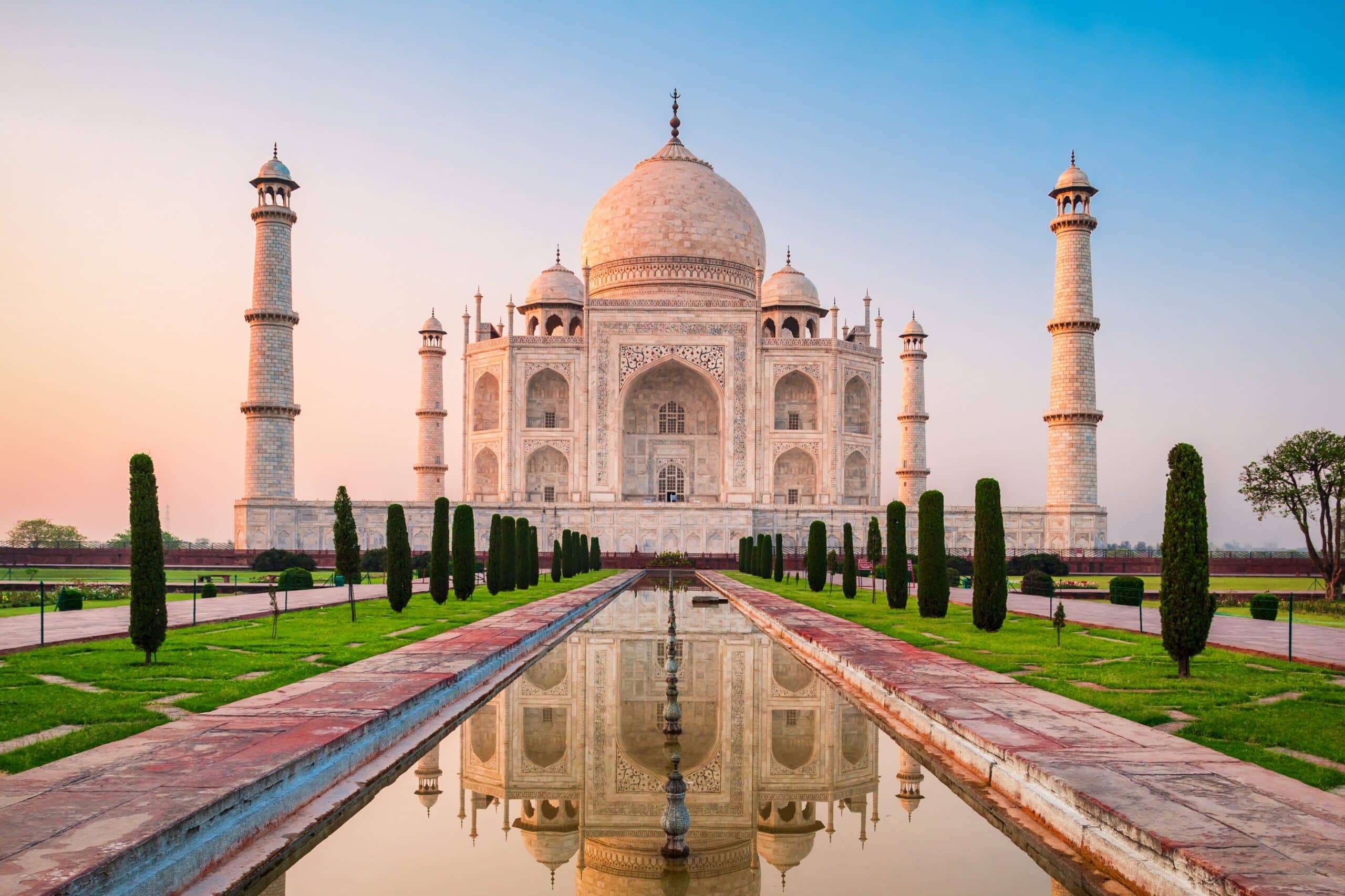
20. Agra
Agra is located on the banks of the Yamuna River in northern India. Geography here is flat alluvial plain within the Indo-Gangetic Basin.
The Yamuna River, flowing southward from the Himalayas, deposits fertile sediment across the region. Seasonal flooding enriches agricultural soils while shaping riverbanks and groundwater levels.
The terrain is predominantly level, facilitating agriculture and urban expansion. The climate is humid subtropical, with hot summers, monsoon rainfall, and cool winters.
Geologically, Agra sits on thick layers of alluvium derived from Himalayan erosion. These sediments accumulate across the northern plains, forming one of the world’s most productive agricultural belts.
Water availability is closely tied to monsoon intensity and upstream Himalayan snowmelt. River health plays a central role in sustaining ecosystems and human settlement.
Endurance here is fluvial and seasonal. Sustainable water management and floodplain protection are essential for long-term ecological balance.
Agra reflects India’s northern river-plain geography — sediment-rich, fertile, and monsoon-dependent. Visitors encounter expansive flatlands shaped by river dynamics, illustrating the enduring influence of Himalayan runoff on northern India.
19. Kerala
Kerala occupies a narrow strip along India’s southwestern coast between the Arabian Sea and the Western Ghats. Geography here is tropical coastal plain backed by forested mountains.
The Western Ghats rise steeply along the eastern boundary, intercepting monsoon winds and producing heavy rainfall. Numerous short rivers descend rapidly from the highlands to the sea, forming lagoons and backwaters along the coast.
The coastal zone consists of sandy beaches, estuaries, and brackish water systems. The famous backwaters are interconnected canals and lakes formed by river deposition and tidal action.
The climate is tropical monsoon, with abundant rainfall from both southwest and northeast monsoon systems. High humidity and consistent temperatures support dense vegetation and biodiversity.
Geologically, Kerala lies on the stable Indian Shield but is influenced by the uplift of the Western Ghats. Laterite soils, formed through intense weathering, dominate much of the landscape.
Endurance here is hydrological and ecological. Sustainable water management and preservation of wetland ecosystems are essential for maintaining biodiversity and agriculture.
Kerala reflects India’s coastal-mountain geography — rain-soaked, river-fed, and sea-bound. Visitors encounter palm-lined backwaters and mist-covered hills that demonstrate the dynamic interaction between monsoon climate and mountainous terrain.
18. Kolkata
Kolkata lies in eastern India along the eastern bank of the Hooghly River, a distributary of the Ganges. Geography here is deltaic lowland shaped by river sediment and tidal influence from the Bay of Bengal.
The city forms part of the greater Ganges-Brahmaputra Delta, one of the largest river deltas in the world. Over thousands of years, Himalayan erosion deposited thick layers of silt and clay, creating fertile but flood-prone terrain.
The Hooghly River serves as a tidal channel, influenced by monsoon rainfall and oceanic currents. Seasonal flooding replenishes soil nutrients while posing risks to infrastructure.
The climate is tropical wet-and-dry, with hot summers and heavy monsoon rains from June to September. High humidity characterizes much of the year.
Geologically, the region sits on deep alluvial deposits overlying the stable Indian Plate. Land subsidence and rising sea levels present long-term environmental challenges.
Endurance here is fluvial and coastal. Flood management, wetland preservation, and sustainable urban drainage are essential in this delta environment.
Kolkata reflects India’s eastern river-delta geography — sediment-built, monsoon-fed, and sea-influenced. Visitors encounter broad river channels and low-lying plains that demonstrate the powerful influence of Himalayan rivers on eastern India.
17. Leh (Ladakh)
Leh is located in the high-altitude region of Ladakh in northern India. Geography here is trans-Himalayan cold desert shaped by tectonic uplift and glacial erosion.
Leh sits at an elevation of approximately 3,500 meters above sea level in the Indus River valley. Surrounding mountains, including parts of the Karakoram and Zanskar ranges, rise dramatically above the arid valley floor.
The region lies in the rain shadow of the Greater Himalayas, receiving minimal monsoon rainfall. As a result, vegetation is sparse and agriculture depends on glacial meltwater irrigation.
Geologically, Ladakh formed through the collision of the Indian and Eurasian plates. The uplift of the Himalayas continues today, making the region seismically active.
Temperatures vary widely, with cold winters and mild summers. Thin air and intense solar radiation characterize the high-altitude environment.
Endurance here is climatic and tectonic. Water management relies on glacier-fed streams, while infrastructure must adapt to extreme cold and seismic conditions.
Leh reflects India’s high-mountain geography — elevated, arid, and tectonically dynamic. Visitors encounter stark valleys and snow-capped peaks that illustrate the immense geological forces shaping the northern frontier.
16. Chennai
Chennai is located on India’s southeastern coast along the Bay of Bengal. Geography here is coastal plain shaped by river sediment, marine processes, and monsoon systems.
The terrain is largely flat and sandy, with low elevation above sea level. Rivers such as the Cooum and Adyar flow through the city, draining inland plains toward the coast.
The climate is tropical wet-and-dry, influenced by both southwest and northeast monsoons. Unlike much of India, Chennai receives significant rainfall from the northeast monsoon between October and December.
Geologically, the region rests on the ancient Indian Shield composed of granitic bedrock overlain by coastal sediments. Shoreline erosion and cyclonic storms are recurring environmental challenges.
The Bay of Bengal exposes the coast to tropical cyclones, requiring careful coastal management and flood resilience.
Endurance here is coastal and monsoonal. Sustainable development depends on water storage, storm preparedness, and shoreline protection.
Chennai reflects India’s southeastern coastal geography — flat, storm-prone, and monsoon-shaped. Visitors encounter long sandy beaches and tidal waters that demonstrate the interaction between continental plains and the Bay of Bengal.
15. Hyderabad
Hyderabad lies in south-central India on the Deccan Plateau. Geography here is elevated basaltic upland shaped by ancient volcanic activity.
The city sits at roughly 500 meters above sea level on rolling granite terrain. Massive rock outcrops, formed over billions of years through erosion of ancient crystalline formations, define much of the surrounding landscape.
Unlike the fertile Indo-Gangetic Plain, the Deccan Plateau consists largely of hard rock and thin soils. Agriculture depends heavily on monsoon rainfall and artificial reservoirs constructed across seasonal rivers such as the Musi.
The climate is tropical semi-arid, with hot summers, moderate monsoon rainfall, and mild winters. Rainfall variability strongly influences water availability.
Geologically, the region is part of the Deccan Traps, created by extensive volcanic eruptions near the end of the Cretaceous period. The plateau slopes gently toward both eastern and western coasts.
Endurance here is climatic and hydrological. Water storage systems and groundwater management are vital for sustaining this inland plateau city.
Hyderabad reflects India’s peninsular plateau geography — rocky, elevated, and monsoon-dependent. Visitors encounter expansive granite landscapes that demonstrate the ancient geological foundation of southern India.
14. Udaipur
Udaipur is situated in southern Rajasthan within the Aravalli Range. Geography here is hilly semi-arid terrain interspersed with artificial lakes.
The Aravalli hills, among the world’s oldest mountain systems, surround the city. These ancient metamorphic ridges create a rugged landscape of rocky slopes and narrow valleys.
Rainfall is limited and seasonal, concentrated during the southwest monsoon. To adapt, historical water harvesting systems created interconnected lakes such as Lake Pichola and Fateh Sagar, capturing seasonal runoff.
The climate is hot semi-arid, with high summer temperatures and mild winters. Vegetation is sparse compared to India’s wetter regions.
Geologically, the Aravalli Range formed through Precambrian tectonic processes and has since undergone extensive erosion, resulting in low but resilient hills.
Endurance here is hydrological. Sustainable settlement depends on effective water conservation in this desert-margin environment.
Udaipur reflects India’s arid hill geography — rocky, monsoon-limited, and water-managed. Visitors encounter reflective lakes framed by ancient hills, illustrating how adaptation to scarce rainfall shapes settlement in Rajasthan.
13. Kaziranga National Park
Kaziranga National Park lies in the northeastern state of Assam along the floodplains of the Brahmaputra River. Geography here is riverine grassland shaped by annual flooding and sediment deposition.
The park occupies a low-lying alluvial plain formed by Himalayan runoff carried by the Brahmaputra and its tributaries. Seasonal floods replenish nutrients, creating fertile grasslands and wetlands.
The terrain consists of tall elephant grass, marshes, and scattered woodlands. Elevation is minimal, and water levels fluctuate dramatically during monsoon months.
The climate is humid subtropical with heavy rainfall from June through September. Flood cycles play a critical ecological role, maintaining biodiversity and preventing forest overgrowth.
Geologically, the Brahmaputra Valley is a foreland basin formed by tectonic collision between the Indian and Eurasian plates. Sediment accumulation continues as mountains erode upstream.
Endurance here is fluvial and ecological. Wildlife survival depends on natural flood cycles and protection of riverine habitats.
Kaziranga reflects India’s northeastern floodplain geography — river-built, monsoon-shaped, and ecologically rich. Visitors encounter vast grasslands and braided river channels that illustrate the dynamic relationship between Himalayan rivers and Assam’s lowlands.
12. Goa
Goa lies on India’s western coast along the Arabian Sea. Geography here is narrow coastal plain backed by the forested slopes of the Western Ghats.
The coastline features sandy beaches, rocky headlands, estuaries, and tidal inlets formed by rivers such as the Mandovi and Zuari. These rivers descend rapidly from the Western Ghats, depositing sediment that shapes coastal wetlands and lagoons.
The Ghats rise sharply inland, intercepting monsoon winds and producing heavy rainfall between June and September. This orographic effect supports dense tropical vegetation and high biodiversity.
Geologically, Goa sits on the Deccan Plateau’s western edge, composed largely of basalt and laterite soils formed through intense weathering. The region’s red laterite cliffs are characteristic of tropical coastal environments.
The climate is tropical monsoon, with a pronounced wet season and warm, humid conditions year-round.
Endurance here is coastal and hydrological. Sustainable tourism and protection of estuaries and mangroves are essential to preserve fragile shoreline ecosystems.
Goa reflects India’s western maritime geography — monsoon-fed, estuarine, and plateau-fringed. Visitors encounter palm-lined beaches and forested hills that demonstrate the interaction between mountain rainfall and coastal sedimentation.
11. Rishikesh
Rishikesh is located in northern India at the foothills of the Himalayas along the Ganges River. Geography here is transitional terrain between mountain highlands and the Indo-Gangetic Plain.
The Ganges emerges from the Himalayas upstream and flows swiftly through narrow valleys before entering broader plains further south. Rishikesh sits where the river descends from mountainous gorges into flatter terrain.
Surrounding hills are part of the Lesser Himalayas, formed by tectonic uplift from the ongoing collision of the Indian and Eurasian plates. The landscape consists of forested slopes, rocky ridges, and river-cut valleys.
The climate is humid subtropical, moderated by elevation. Summers are warm, monsoon rains are substantial, and winters are cooler than in the plains.
Geologically, the region is seismically active due to Himalayan uplift. River flow varies seasonally, influenced by glacial melt and monsoon rainfall.
Endurance here is tectonic and fluvial. River management and slope stabilization are vital for protecting settlements along steep terrain.
Rishikesh reflects India’s Himalayan foothill geography — river-carved, uplifted, and monsoon-influenced. Visitors encounter fast-flowing waters and rising mountain ridges that illustrate the dynamic transition from high peaks to fertile plains.
10. Mysuru
Mysuru lies in southern India on the Deccan Plateau, southwest of Bengaluru. Geography here is gently undulating upland shaped by ancient crystalline rock formations.
The region sits at an elevation of approximately 750 meters above sea level, contributing to a relatively moderate climate compared to coastal zones. Granite hills and isolated rocky outcrops punctuate the plateau landscape.
The Cauvery River flows nearby, supporting irrigation and agriculture across surrounding districts. Seasonal monsoon rains replenish reservoirs and sustain crop cycles.
Geologically, Mysuru rests on the Indian Shield — some of the planet’s oldest continental crust. Over millions of years, erosion smoothed the plateau into rolling terrain.
The climate is tropical savanna, with warm summers, moderate monsoon rainfall, and mild winters. Rainfall is less intense than along the Western Ghats, located further west.
Endurance here is climatic and hydrological. Water conservation and plateau watershed management remain important for sustaining agriculture and urban growth.
Mysuru reflects India’s southern plateau geography — elevated, granite-based, and monsoon-dependent. Visitors encounter broad horizons and rocky hills that demonstrate the ancient geological foundations of peninsular India.
9. Amritsar
Amritsar is located in the northwestern state of Punjab near the border with Pakistan. Geography here is flat alluvial plain within the larger Indus River basin.
The terrain consists of fertile sediments deposited over centuries by tributaries of the Indus system. Although the main Indus River flows west of the city, regional irrigation networks distribute river water across agricultural lands.
Punjab’s plains are among the most productive agricultural regions in India, supported by monsoon rainfall and extensive canal irrigation. The landscape is largely level, facilitating farming and settlement.
The climate is semi-arid to sub-humid, with hot summers, monsoon rains, and cool winters. Rainfall is moderate compared to eastern India but sufficient when combined with irrigation systems.
Geologically, the region sits on thick alluvial deposits eroded from the Himalayas. Ongoing tectonic uplift in the north continues to feed sediment into the plains.
Endurance here is hydrological and agricultural. Sustainable water management is critical due to groundwater depletion in intensively farmed areas.
Amritsar reflects India’s northwestern plain geography — river-fed, level, and agriculturally dominant. Visitors encounter expansive fields and canal systems that demonstrate how Himalayan runoff sustains life across Punjab.
8. Darjeeling
Darjeeling lies in the Lesser Himalayas of West Bengal at an elevation of over 2,000 meters. Geography here is steep mountain terrain shaped by tectonic uplift and erosion.
The town is perched along a ridge overlooking deep valleys and forested slopes. Clear days offer views of Kangchenjunga, one of the world’s highest peaks, rising in the eastern Himalayas.
The climate is temperate compared to India’s plains, with cool winters, mild summers, and heavy monsoon rainfall. Mist and cloud cover frequently envelop the hills.
Geologically, Darjeeling sits within the Himalayan orogenic belt formed by the collision of the Indian and Eurasian plates. Steep gradients and unstable slopes make the region prone to landslides, especially during the monsoon.
Mountain streams descend rapidly toward the Teesta River basin, feeding downstream floodplains in Assam and Bangladesh.
Endurance here is tectonic and climatic. Infrastructure must adapt to steep terrain, seismic activity, and seasonal rainfall.
Darjeeling reflects India’s eastern Himalayan geography — elevated, rain-soaked, and tectonically active. Visitors encounter layered mountain ridges and cool highland air that illustrate the immense geological forces shaping the Himalayan frontier.
7. Jaisalmer
Jaisalmer is located in western Rajasthan within the Thar Desert. Geography here is arid sandy terrain shaped by wind erosion and sparse rainfall.
The landscape consists of rolling sand dunes, rocky desert outcrops, and dry seasonal riverbeds. Rainfall is minimal and highly variable, occurring primarily during brief monsoon periods.
The climate is hot desert, with extreme summer temperatures and cool winter nights. Evaporation rates are high, limiting surface water availability.
Geologically, the Thar Desert formed through a combination of climatic shifts and sediment deposition over millions of years. Sand dunes migrate gradually under prevailing winds, continually reshaping the terrain.
Vegetation is sparse and drought-resistant, adapted to arid conditions. Groundwater resources are limited and carefully managed.
Endurance here is climatic and hydrological. Traditional water storage systems and modern conservation practices are essential for sustaining life in this harsh environment.
Jaisalmer reflects India’s desert geography — wind-shaped, sun-dominated, and water-scarce. Visitors encounter vast dune fields and open horizons that demonstrate the stark contrast between Rajasthan’s arid west and India’s fertile river plains.
6. Bhopal
Bhopal is located in central India on the Malwa Plateau. Geography here is elevated basaltic terrain shaped by ancient volcanic activity associated with the Deccan Traps.
The city stands at roughly 500 meters above sea level and is characterized by undulating uplands interspersed with natural and artificial lakes. The Upper and Lower Lakes were formed through damming seasonal streams, creating important freshwater reservoirs.
The surrounding plateau consists primarily of basalt rock overlain by black cotton soil, which retains moisture and supports agriculture. Seasonal rivers drain toward the Narmada and Betwa basins.
The climate is humid subtropical, with hot summers, monsoon rains from June to September, and mild winters. Rainfall variability influences water storage levels and agricultural output.
Geologically, Bhopal lies on one of the world’s largest volcanic provinces, formed around 66 million years ago. Over time, erosion sculpted the plateau into rolling hills and shallow valleys.
Endurance here is hydrological and climatic. Lake preservation and watershed management are critical for sustaining water supplies in this inland plateau environment.
Bhopal reflects India’s central plateau geography — volcanic, elevated, and monsoon-dependent. Visitors encounter lake-dotted uplands that illustrate the ancient basaltic foundation of peninsular India.
5. Gangtok
Gangtok lies in the eastern Himalayas at an elevation of approximately 1,650 meters. Geography here is steep mountain terrain formed by tectonic uplift along the Himalayan collision zone.
The city is perched on a ridge overlooking deep valleys carved by tributaries of the Teesta River. Surrounding slopes are densely forested, while higher elevations rise toward snow-covered peaks.
The climate is temperate to cool, with heavy monsoon rainfall and occasional winter snowfall at higher altitudes. Mist and cloud frequently blanket the hills during the wet season.
Geologically, Sikkim sits within one of the most active tectonic zones in the world. The ongoing collision between the Indian and Eurasian plates continues to uplift the region, making it seismically sensitive.
Fast-flowing rivers descending from glaciers supply water downstream, sustaining ecosystems and settlements across northeastern India.
Endurance here is tectonic and climatic. Landslide mitigation and earthquake preparedness are vital for long-term stability.
Gangtok reflects India’s high Himalayan geography — uplifted, forested, and river-carved. Visitors encounter dramatic mountain slopes and deep valleys that illustrate the dynamic forces shaping the eastern Himalayas.
4. Puducherry
Puducherry is located on India’s southeastern coast along the Bay of Bengal. Geography here is low-lying coastal plain shaped by marine processes and river sedimentation.
The terrain is flat and sandy, with gentle shoreline gradients. Seasonal rivers and backwater systems contribute sediment that influences coastal morphology.
The climate is tropical wet-and-dry, influenced strongly by the northeast monsoon between October and December. Cyclonic storms from the Bay of Bengal periodically impact the coast.
Geologically, Puducherry rests on ancient crystalline bedrock overlain by marine and riverine sediments. Coastal erosion and storm surges are recurring environmental challenges.
Groundwater resources depend on monsoon recharge, and saltwater intrusion poses risks in low-elevation areas.
Endurance here is coastal and monsoonal. Shoreline protection, storm preparedness, and sustainable water management are essential for resilience.
Puducherry reflects India’s southeastern coastal geography — flat, cyclone-exposed, and monsoon-shaped. Visitors encounter broad beaches and tidal waters that demonstrate the delicate balance between land and sea along the Bay of Bengal.
3. Andaman Islands
Andaman Islands lie in the Bay of Bengal, southeast of mainland India. Geography here is tropical island arc formed by tectonic activity along the boundary between the Indian and Burmese plates.
The islands are part of a submerged mountain chain extending from Myanmar to Indonesia. Steep forested hills rise directly from the sea, while narrow coastal plains fringe sections of the shoreline.
Coral reefs surround many islands, thriving in warm, clear waters. Mangroves and tidal creeks line sheltered bays, creating diverse coastal ecosystems.
The climate is tropical maritime, with high humidity and substantial rainfall during both southwest and northeast monsoons. Cyclonic systems occasionally affect the region.
Geologically, the Andamans are shaped by subduction processes similar to those forming Indonesia’s volcanic arcs. Earthquakes are relatively frequent, and the region was significantly impacted by the 2004 Indian Ocean tsunami.
Endurance here is tectonic and marine. Coastal protection and ecosystem preservation are critical for long-term sustainability.
The Andaman Islands reflect India’s oceanic geography — forested, reef-fringed, and plate-boundary formed. Visitors encounter dense tropical landscapes rising from turquoise waters that illustrate India’s extension into Southeast Asia’s tectonic arc.
2. Shimla
Shimla is located in the western Himalayas at an elevation of approximately 2,200 meters. Geography here is steep mountain terrain shaped by tectonic uplift and river erosion.
The city occupies a narrow ridge surrounded by forested hills and deep valleys. Seasonal streams descend toward tributaries of the Sutlej River, contributing to the larger Indus basin.
The climate is temperate, with cool summers, heavy monsoon rainfall, and occasional winter snowfall. The elevation moderates temperatures compared to the plains below.
Geologically, Shimla lies within the Lesser Himalayan zone, formed through ongoing collision between the Indian and Eurasian plates. The region is seismically active and prone to landslides during intense rainfall.
Vegetation includes pine and cedar forests, sustained by orographic precipitation as moist air rises along mountain slopes.
Endurance here is tectonic and climatic. Infrastructure must adapt to steep gradients, seismic activity, and monsoon-driven erosion.
Shimla reflects India’s western Himalayan geography — elevated, forested, and tectonically dynamic. Visitors encounter layered ridges and cool mountain air that demonstrate the immense geological forces shaping northern India.
1. Hampi
Hampi is located in southern India along the Tungabhadra River within Karnataka’s Deccan Plateau. Geography here is rocky upland terrain formed from ancient granite formations.
The landscape is characterized by massive boulder-strewn hills created through millions of years of weathering and erosion of crystalline rock. These granite outcrops rise above relatively flat valley floors.
The Tungabhadra River flows through the region, supporting irrigation and agriculture in an otherwise dry plateau environment. Seasonal monsoon rainfall replenishes reservoirs and groundwater.
The climate is tropical semi-arid, with hot summers and moderate monsoon rains. Vegetation is sparse on exposed hills but more concentrated along riverbanks.
Geologically, Hampi lies on part of the Indian Shield, among the oldest continental crust on Earth. Long-term erosion sculpted the distinctive boulder landscapes seen today.
Endurance here is climatic and fluvial. Water conservation and plateau watershed management are essential for sustaining agriculture and settlement.
Hampi reflects India’s southern plateau geography — granite-based, river-fed, and monsoon-shaped. Visitors encounter dramatic rock formations and river valleys that illustrate the ancient geological foundations of peninsular India.