
Libya occupies a vast and often misunderstood geography, yet its identity emerges not from isolation but from connection. Positioned between the Mediterranean Sea and the Sahara Desert, Libya has long functioned as a bridge—linking Africa’s interior with coastal worlds, caravans with ports, and ancient civilizations with enduring landscapes. Its territory holds layers of memory shaped by movement, exchange, and survival.
For thousands of years, Libyan land facilitated interaction. Phoenicians, Greeks, Romans, Berbers, Arabs, and Ottomans all passed through or settled here, leaving imprints shaped by geography rather than conquest alone. The coastline invited trade and maritime life, while the desert demanded discipline, cooperation, and knowledge of natural systems. Libya’s history is therefore spatial as much as chronological.
The Sahara dominates the nation’s interior, imposing scale and restraint. Vast sand seas, rocky plateaus, and hidden oases frame human presence, reminding inhabitants of proportion between ambition and endurance. Life here has always depended on adaptation—knowing when to move, when to settle, and how to share limited resources.
Along the Mediterranean, contrast emerges. Fertile plains, harbors, and cities face outward, historically tied to wider worlds. These coastal zones absorbed influence while maintaining local structure, producing layered identities rather than uniform culture.
Libya’s strength lies in continuity rather than spectacle. Its landscapes resist simplification, and its cities reveal meaning slowly, through alignment with land and history. Even amid modern disruption, geography remains the stabilizing force, anchoring identity through permanence.
22. Tripoli: Mediterranean Capital of Continuity
Tripoli stretches along the Mediterranean as Libya’s capital and most enduring urban center. Its identity is shaped by coastal openness balanced against layered history, where successive civilizations adapted the same strategic shoreline rather than replacing it.
The city’s harbor has long anchored trade and communication. Phoenician foundations, Roman expansion, and Ottoman administration each left architectural and spatial traces, visible in the medina’s narrow streets and fortified walls. Rather than monumental scale, Tripoli’s strength lies in continuity of use.
Daily life unfolds through markets, mosques, and residential quarters that maintain rhythm despite modern pressures. Social interaction centers on proximity, reinforcing cohesion through shared spaces rather than grand planning.
The sea defines perspective. It frames the city outwardly, connecting Tripoli to wider Mediterranean networks while tempering desert encroachment from the south. This balance between openness and defense shapes urban character.
Tripoli represents Libya’s coastal identity—adaptive, resilient, and layered. It shows how cities persist by absorbing change without losing orientation, anchored by geography and long memory rather than spectacle.
21. Leptis Magna: Empire Written in Stone
Leptis Magna stands east of Tripoli as one of the Mediterranean world’s most intact Roman cities. Its ruins rise directly from coastal plains, illustrating how empire once aligned architecture with geography.
Founded by Phoenicians and expanded under Roman rule, Leptis Magna flourished through trade, agriculture, and strategic placement. Forums, basilicas, and harbors remain preserved not through reconstruction, but through abandonment shaped by shifting routes.
The city’s layout reflects Roman order imposed upon African terrain. Columns frame open spaces, streets guide movement toward the sea, and public buildings reinforce civic structure. Yet surrounding sand reminds visitors of impermanence.
Leptis Magna exists today as silence and scale. The absence of modern settlement allows the landscape to speak, revealing continuity through preservation rather than use.
It represents Libya’s classical depth—evidence of how global systems once depended on this coast, and how geography sustains memory long after power fades.
20. Ghadames: Oasis of Architecture and Adaptation
Ghadames lies in northwestern Libya as a desert oasis city renowned for architectural innovation and environmental adaptation. Known as the “Pearl of the Desert,” it reflects how human settlement can harmonize with extreme conditions.
The old city is built inward. Covered walkways, thick walls, and elevated roofs regulate temperature, while communal spaces foster cooperation. Architecture here is climate response, not decoration.
Water defines survival. Springs and irrigation channels support date palms and small gardens, sustaining life amid surrounding desert. Knowledge of water management is inherited, precise, and respected.
Social organization reinforces balance. Families and neighborhoods share responsibility for maintenance, ensuring continuity through collective care rather than individual ownership.
Ghadames represents Libya’s desert intelligence. It shows how restraint, design, and cooperation allow culture to endure in harsh landscapes, producing beauty through necessity.
19. Jebel Akhdar: Green Highlands of the East
Jebel Akhdar rises in eastern Libya as a rare zone of elevation and fertility. Its name, meaning “Green Mountain,” reflects rainfall, forests, and agricultural potential uncommon in North Africa.
Terraced farming supports olives, grains, and fruit. Villages cluster along slopes, adapting architecture to gradient and climate. Life here follows seasonal cycles shaped by rainfall rather than desert scarcity.
Historically, the region supported Greek and Roman settlements, later sustaining rural Libyan communities through continuity of cultivation.
Jebel Akhdar represents ecological contrast within Libya. It shows how variation in geography produces diverse cultural rhythms, reinforcing the country’s complexity beyond desert narratives.
18. Cyrene: Greek Thought at the Edge of Africa
Cyrene lies in eastern Libya on the slopes of the Jebel Akhdar, overlooking fertile valleys that once supported one of the ancient world’s most influential Greek cities. Founded in the 7th century BCE, Cyrene thrived not through conquest, but through alignment with land and climate.
The city’s position allowed agriculture to flourish. Rainfall, rare in much of Libya, sustained grain fields and olive groves, enabling economic independence and intellectual life. Cyrene became a center of philosophy, medicine, and governance, producing thinkers whose ideas traveled across the Mediterranean.
Its ruins reveal order and restraint. Temples, theaters, and public spaces follow terrain rather than overpower it. Columns frame views of valleys and sea, reinforcing harmony between human design and environment.
Cyrene declined as trade routes shifted, yet its abandonment preserved integrity. Today, the site speaks through silence, where stone outlines civic ambition grounded in ecological awareness.
Cyrene represents Libya’s intellectual inheritance. It shows how knowledge flourishes where environment supports stability, and how cultural legacy endures when built in proportion to land. The city remains a testament to thought rooted in place.
17. Benghazi: Port of Resistance and Renewal
Benghazi stands along Libya’s eastern Mediterranean coast as a city shaped by endurance, resistance, and adaptation. Historically a modest port, it grew through trade, migration, and strategic relevance rather than imperial ambition.
The harbor defines Benghazi’s orientation. Maritime trade connected the city to Levantine and North African networks, shaping cosmopolitan character without erasing local identity. Neighborhoods grew outward from the coast, structured by movement and exchange.
Benghazi’s modern history is marked by resilience. Repeated cycles of destruction and rebuilding reinforced collective memory and civic identity. Markets, mosques, and family structures sustained continuity through instability.
The city’s geography fosters openness. Flat coastal plains allow expansion, yet proximity to desert reinforces awareness of limits. Benghazi exists between exposure and protection, shaped by necessity rather than excess.
Benghazi represents Libya’s capacity for renewal. It shows how cities persist through social cohesion and geographic grounding, maintaining identity even when material structures are disrupted.
16. Fezzan: Saharan Crossroads of Trade and Survival
Fezzan occupies southwestern Libya as a vast Saharan region defined by trade routes, oases, and nomadic movement. For centuries, it functioned as a connective corridor linking sub-Saharan Africa with the Mediterranean.
Caravan routes structured life. Salt, gold, and textiles moved north and south, sustained by oases that punctuated desert expanses. Survival depended on cooperation, knowledge of terrain, and seasonal timing.
Settlements like Sabha and Murzuq emerged as nodes of exchange rather than cities of scale. Architecture prioritized defense and climate adaptation, using mud-brick and compact forms to regulate heat.
Fezzan’s culture reflects mobility. Social structures accommodate movement, negotiation, and shared responsibility, reinforcing resilience through flexibility.
Fezzan represents Libya’s interior intelligence. It shows how desert regions function not as voids, but as active systems of exchange shaped by discipline, trust, and environmental respect.
15. Murzuq: Fortress of the Deep Desert
Murzuq lies deep within the Fezzan as a historic fortified town that once controlled Saharan trade networks. Its walls and citadel reflect strategic necessity shaped by isolation and exposure.
The town developed around protection. Thick walls, narrow streets, and elevated structures defend against heat and conflict alike. Architecture here expresses survival rather than ornament.
Water access defines Murzuq’s existence. Wells and underground channels sustain limited agriculture, reinforcing precision in resource management.
Murzuq’s role as caravan hub fostered cultural exchange across Africa, linking Tuareg, Arab, and sub-Saharan communities. Social cohesion depended on negotiation and mutual reliance.
Murzuq represents endurance at the margins. It shows how human settlement persists through adaptation, cooperation, and respect for harsh environments. In its restraint, Murzuq embodies Libya’s deep Saharan resilience.
14. Sabratha: Theatre Between Sea and Empire
Sabratha lies along Libya’s western Mediterranean coast as a city where architecture, sea, and empire intersect. Founded by Phoenicians and later expanded under Roman rule, it flourished through maritime trade and cultural exchange rather than military dominance.
The city’s most striking feature, its Roman theatre, rises directly above the shoreline. Columns frame the sea beyond, creating a dialogue between human design and natural horizon. This placement reflects confidence rooted in geography—power aligned with access rather than defense.
Sabratha’s urban plan reveals balance. Forums, temples, and residential quarters follow coastal contours, integrating civic life with maritime movement. Trade routes connected the city to Africa’s interior and Mediterranean ports, sustaining prosperity through circulation.
When routes shifted, Sabratha declined, leaving structures exposed to sand and salt air. Preservation came through abandonment, allowing stone to weather naturally while retaining integrity.
Sabratha represents Libya’s coastal memory. It shows how cities flourish when oriented toward exchange and how architecture becomes enduring when aligned with landscape. Today, the ruins speak not of conquest, but of balance between sea, land, and human ambition.
13. Kufra Oases: Isolation and Inner Navigation
Kufra lies deep in southeastern Libya as a cluster of oases surrounded by vast desert. Its remoteness defines its identity, shaping life through isolation, navigation, and precision.
Water is the governing force. Underground aquifers and carefully managed wells sustain palm groves and small-scale agriculture. Every action—planting, movement, settlement—is calculated against scarcity.
Historically, Kufra served as a waypoint for trans-Saharan travel and spiritual retreat. Its distance from major routes fostered introspection, discipline, and independence. Social structures emphasize trust and cooperation, essential for survival.
Architecture reflects inward focus. Homes cluster tightly, shielding inhabitants from heat and sand, while communal spaces reinforce cohesion. Movement beyond the oasis requires preparation and shared knowledge.
Kufra represents Libya’s inward geography. It shows how endurance is cultivated through restraint and how isolation can produce clarity rather than deprivation. In its silence, Kufra reveals the power of orientation guided by land rather than direction alone.
12. Prehistoric Rock Art of the Acacus Mountains
The Acacus Mountains rise in southwestern Libya as a sandstone plateau preserving one of Africa’s richest collections of prehistoric rock art. These images reveal a Sahara once green, inhabited, and dynamic.
Paintings depict cattle, wildlife, and human figures, recording climatic shifts and social evolution over thousands of years. They show movement, ritual, and adaptation, capturing history long before written record.
The mountains themselves shape preservation. Overhangs and caves shelter art from erosion, while isolation protects sites from disturbance. Geography becomes archivist, holding memory in stone.
These images testify to transformation. As climate changed, people adapted, migrating or redefining survival. The art remains as evidence of continuity through change.
The Acacus represents Libya’s deepest memory. It shows that history here extends beyond cities and empires, rooted instead in landscape and human response to environmental transformation.
11. Zuwara: Berber Coast and Living Language
Zuwara lies near Libya’s western border as a coastal town shaped by Berber heritage and maritime life. Unlike imperial cities, its identity emerges through continuity of language, tradition, and localized rhythm.
Fishing defines daily movement. Boats launch with tides, and markets align with catch cycles. The sea sustains economy and social interaction, reinforcing proximity-based cohesion.
Zuwara’s Berber culture remains active rather than symbolic. Language, architecture, and ritual persist through daily use, anchoring identity in practice rather than preservation.
Urban form remains modest. Residential areas cluster near the coast, reinforcing walkability and communal presence. Expansion occurs cautiously, respecting existing social fabric.
Zuwara represents Libya’s cultural persistence. It shows how minority identities endure through geography and daily repetition. Here, heritage is not curated—it is lived.
10. Ghat: Desert Gateway of the Tuareg
Ghat lies near Libya’s southern border as a historic Tuareg settlement positioned between mountains and desert plains. Its role as gateway shaped movement, trade, and cultural exchange across Sahara routes.
The town’s layout reflects adaptation. Narrow streets, mud-brick structures, and fortified edges regulate climate and security. Life here depends on negotiation with environment.
Tuareg culture emphasizes mobility, honor, and shared responsibility. Music, dress, and oral tradition preserve identity through transmission rather than inscription.
Ghat’s position enabled mediation between regions, linking Libya to Niger and Algeria. Exchange sustained economy and reinforced cross-cultural understanding.
Ghat represents desert continuity. It shows how movement sustains identity and how border spaces generate connection rather than division. In its endurance, Ghat anchors Libya’s Saharan soul.
9. Sirte: Coastline of Transition and Centrality
Sirte lies along Libya’s central Mediterranean coast, positioned between the historic regions of Tripolitania and Cyrenaica. Its geography grants it symbolic and practical centrality, shaping identity through connection rather than dominance.
The coastline defines Sirte’s rhythm. Long beaches, shallow waters, and open horizons emphasize exposure rather than enclosure. Historically, movement through Sirte mattered more than settlement scale, making it a point of passage and mediation.
Urban development here reflects modern layering. Infrastructure and housing expanded rapidly, yet the surrounding desert and sea continue to impose restraint. Life unfolds between openness and vulnerability, shaping collective awareness of geography.
Social organization emphasizes locality. Families, markets, and mosques structure daily life, maintaining cohesion despite disruption. Sirte’s people orient themselves through land familiarity rather than monumentality.
Sirte represents Libya’s geographic midpoint. It shows how places of passage carry meaning through balance, and how centrality can foster connection rather than control. The city stands as a reminder that geography often defines importance more quietly than power.
8. Tobruk: Eastern Harbor of Endurance
Tobruk sits near Libya’s eastern border as a natural harbor shaped by protection, isolation, and resilience. Its deep bay offers shelter from Mediterranean winds, making it strategically significant throughout history.
The city’s layout follows the curve of the harbor. Port activity, fishing, and maritime movement anchor daily life, reinforcing dependence on the sea. Unlike larger cities, Tobruk retains a measured pace shaped by geography.
Historical layers include ancient trade, wartime fortifications, and modern adaptation. Defensive structures reflect necessity rather than ambition, responding to exposure rather than asserting dominance.
The surrounding landscape is sparse. Desert meets coast abruptly, limiting expansion and reinforcing inward cohesion. Social life centers on proximity, trust, and continuity.
Tobruk represents Libya’s eastern endurance. It shows how harbor cities persist through protection offered by landform rather than scale. Here, survival and identity are anchored in geography’s quiet advantages.
7. Jalu Oasis: Water, Memory, and Interior Life
Jalu lies deep within Libya’s interior as an oasis sustained by underground water and precise agricultural practice. Its existence depends on balance—between scarcity and use, isolation and connection.
Palm groves define space. Date cultivation structures economy, ritual, and seasonal rhythm. Irrigation follows inherited knowledge, ensuring continuity through care rather than expansion.
Architecture clusters inward. Homes and communal spaces protect against heat and wind, reinforcing social cohesion. Movement beyond the oasis requires preparation, reinforcing awareness of environmental limits.
Historically, Jalu served caravan routes linking the coast with Saharan interiors. Exchange passed through quietly, shaping culture without overwhelming it.
Jalu represents Libya’s interior resilience. It shows how life persists through discipline and restraint, and how oases function as anchors of memory within vast desert systems.
6. Nalut: Mountain Granaries and Amazigh Continuity
Nalut rises in Libya’s western Nafusa Mountains as a settlement defined by elevation, stone architecture, and Amazigh heritage. Its position offered protection, autonomy, and agricultural control.
The town is known for its communal granaries—fortified structures storing grain for collective security. These buildings reflect cooperation, foresight, and shared responsibility.
Mountain agriculture shapes rhythm. Terraced fields and seasonal rainfall sustain crops, while elevation moderates climate. Life follows environmental cycles rather than external schedules.
Amazigh language and tradition remain active in Nalut. Identity is preserved through daily use, oral transmission, and communal practice rather than symbolic display.
Nalut represents Libya’s highland continuity. It shows how geography protects culture and how collective organization ensures survival. In its stone walls and shared granaries, Nalut embodies resilience rooted in cooperation.
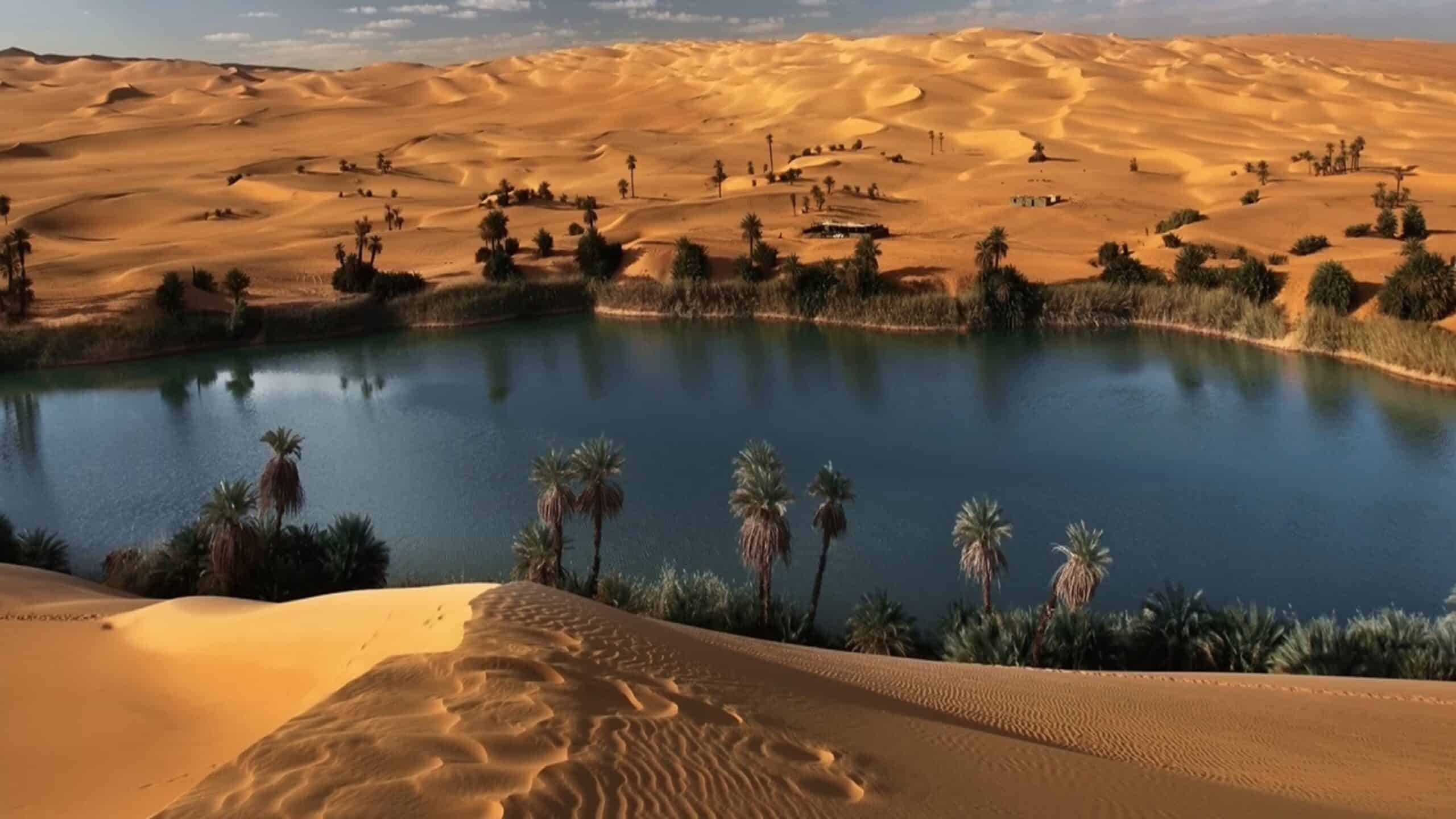
5. Awbari Lakes: Desert Water and Tuareg Balance
The Awbari Lakes lie deep within Libya’s Fezzan region as a striking convergence of sand, salt, and water. Surrounded by towering dunes, these lakes appear unexpectedly, shaping life through contrast rather than abundance.
Water here is saline, yet date palms and vegetation grow nearby, sustained by underground freshwater lenses. This delicate balance requires precise knowledge of soil and hydrology, passed through Tuareg communities over generations.
The lakes structure movement and settlement. Camps and villages form at respectful distances, avoiding overuse while maintaining access. Daily rhythm follows sun, wind, and seasonal variation rather than rigid schedules.
Cultural life emphasizes restraint. Tuareg traditions prioritize mobility, stewardship, and negotiation with environment. The lakes are treated as shared resources, not commodities.
Awbari represents Libya’s fragile interior systems. It shows how life persists not by domination but by alignment with limits. In the stillness of water framed by sand, the region reflects the discipline and wisdom required to sustain human presence in extreme landscapes.
4. Zliten: Spiritual Anchoring on the Coast
Zliten lies east of Tripoli along the Mediterranean coast as a town shaped by religious learning, agriculture, and coastal rhythm. Its identity is anchored less in scale than in continuity of practice.
The city is renowned for its Islamic scholarship and religious institutions, which structure education and community life. Knowledge here is transmitted through proximity—teachers, students, and families interwoven in daily routine.
Agricultural land stretches inland from the coast, supporting olives, grains, and small gardens. Farming complements spiritual life, reinforcing balance between labor and reflection.
Urban form remains modest. Residential areas cluster around mosques and markets, emphasizing walkability and social cohesion. Expansion follows necessity rather than ambition.
Zliten represents Libya’s spiritual continuity. It shows how faith-based learning and grounded agriculture sustain identity across generations. Here, the coast serves not as gateway outward, but as stabilizing edge for inward focus.
3. Bani Walid: Valley Settlement and Tribal Memory
Bani Walid lies southeast of Tripoli within a broad valley shaped by seasonal rivers and fertile soil. Its geography supports agriculture and settlement while reinforcing strong tribal organization.
Date palms and crops line the valley floor, sustained by rainfall and runoff from surrounding highlands. Farming determines rhythm, aligning community life with seasonal cycles.
Social structure emphasizes kinship and memory. Tribal affiliation shapes governance, dispute resolution, and mutual support, reinforcing continuity through shared history rather than formal institutions alone.
Architecture reflects adaptation. Homes cluster along elevated ground to avoid flooding, while communal spaces facilitate negotiation and gathering.
Bani Walid represents Libya’s inland social cohesion. It shows how valleys anchor settlement and how tribal systems sustain order through familiarity and shared responsibility. Geography here reinforces memory, grounding identity in land and lineage.
2. Ras Lanuf: Industry at the Desert’s Edge
Ras Lanuf sits along Libya’s central coast as an industrial port defined by oil infrastructure and exposure to open sea and desert. Its identity emerges from function rather than heritage.
Refineries and terminals dominate the skyline, yet the surrounding landscape imposes restraint. Desert winds, salt air, and isolation limit unchecked expansion, reminding inhabitants of environmental boundaries.
Life here revolves around work cycles and logistical coordination. Despite industrial focus, social organization depends on cooperation and shared routines.
Ras Lanuf represents Libya’s modern interface with global systems. It shows how industry adapts to geography rather than erasing it. Even here, land and sea remain dominant forces shaping rhythm and scale.
1. Waw an Namus: Volcanic Silence of the Sahara
Waw an Namus lies in remote southern Libya as a volcanic crater surrounded by black basalt and ash fields. At its center, small lakes and vegetation create an otherworldly contrast.
The site is uninhabited, yet culturally significant. Nomadic groups pass nearby, guided by landmarks and oral knowledge. Movement here requires precision and respect.
The crater illustrates geological time rather than human history. Its presence reframes perception, reminding visitors of forces that predate settlement and civilization.
Waw an Namus represents Libya’s elemental depth. It shows how landscape alone can define meaning, reinforcing humility and perspective. In its isolation, the crater anchors Libya’s identity to planetary scale rather than human ambition.