
Vietnam stretches in a long, narrow arc along the eastern edge of mainland Southeast Asia. Geography here is elongated and coastal. The country extends more than 1,600 kilometers from north to south, yet remains comparatively narrow from west to east, compressed between the South China Sea and inland mountain ranges.
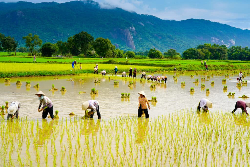
The Annamite Range forms a mountainous spine along much of the western frontier, while fertile deltas anchor the north and south. Geography shapes dual centers of agricultural productivity: the Red River Delta in the north and the Mekong Delta in the south. Between them lies a shifting landscape of highlands, coastal plains, and river valleys.
Monsoon patterns govern climate across the country. Geography reinforces seasonal rhythm—humid summers, variable rainfall, and regional microclimates shaped by elevation and proximity to sea. Typhoons approach from the east, affecting low-lying coastlines and river basins.
Movement through Vietnam often follows longitudinal routes. Mountains restrict direct west-east passage, encouraging travel along the coastal corridor. Rivers descend from highlands toward the sea, forming natural agricultural arteries.
Vietnam inspires through contrast within continuity. The land teaches endurance through adaptation to water, wind, and elevation. Rice cultivation reflects geographic alignment with flood cycles and fertile sediment.
Endurance here is hydrological and coastal. Geography binds mountain runoff, delta formation, and maritime exposure into one integrated system. The country’s resilience emerges from its long shoreline and river-fed plains.
Vietnam reflects a landscape where endurance is shaped by proximity to sea and mountain alike, forming a nation defined by water, elevation, and seasonal balance.
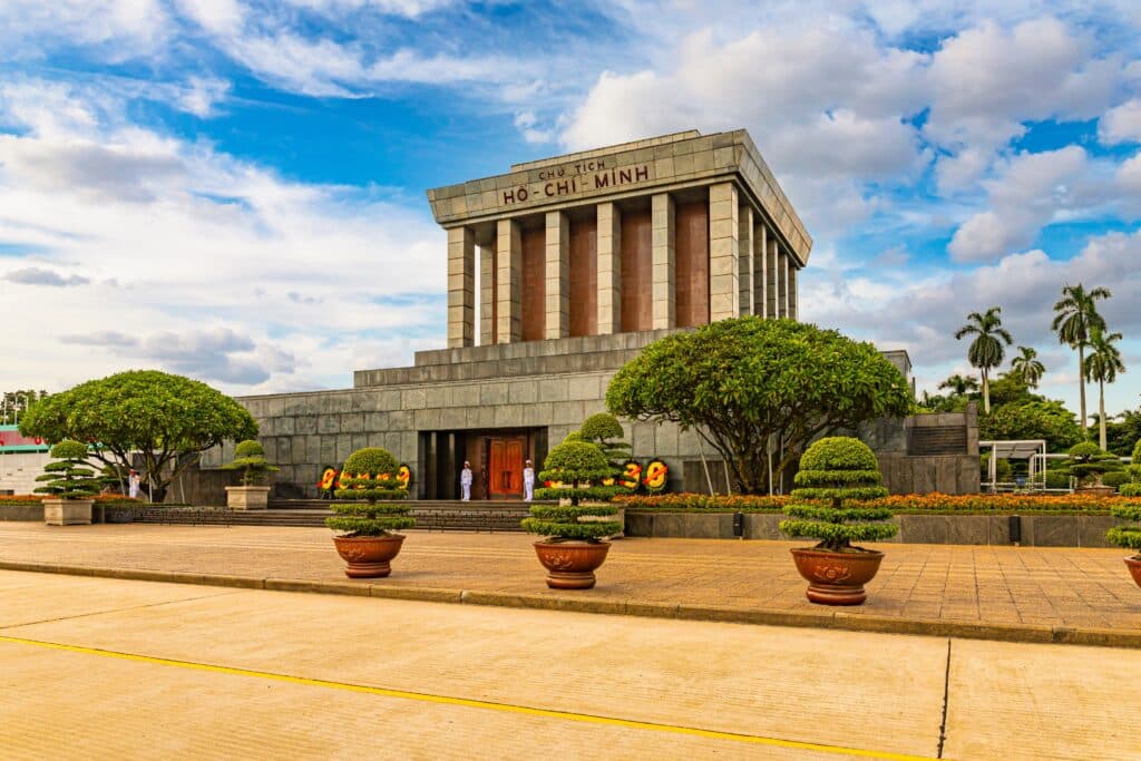
21. Ho Chi Minh City

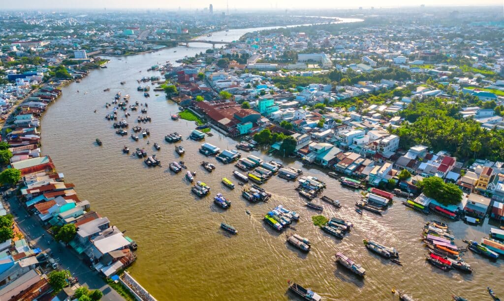
Ho Chi Minh City lies in southern Vietnam near the confluence of the Saigon and Đồng Nai rivers, forming part of the Mekong Delta’s upper reaches. Geography here is low-lying and fluvial, situated on a network of alluvial plains deposited over centuries by sediment from upstream rivers. The terrain is mostly flat, allowing extensive urban expansion across formerly marshy areas now stabilized through canalization and embankments.

The city occupies a strategic position near the southern coastline, just inland from the South China Sea. Geography reinforces its role as a commercial hub, linking interior provinces to coastal ports. Rivers and canals historically facilitated transport and trade, creating natural arteries for goods and people that shaped urban settlement patterns.

Rainfall is concentrated during the monsoon season, producing significant seasonal variation in water levels. Geography requires drainage management and flood mitigation to protect densely populated districts. Elevated roads and embankments are integrated into urban design to align with hydrological rhythms.

Movement through Ho Chi Minh City follows a combination of river channels, radial roads, and dense urban streets. Geography emphasizes horizontal expansion, with urban density reinforced by the flat delta plain rather than by vertical elevation. The river system remains a defining geographic feature, guiding both transport and city planning.
Ho Chi Minh City inspires through connectivity. The land teaches endurance through adaptation to water and seasonal fluctuation, showing how resilience develops when urban life aligns with natural river flow rather than attempting to override it.
Endurance here is fluvial and infrastructural. Geography requires integration of drainage, road networks, and river access to maintain functionality and mitigate flood risk. Stability depends on harmonizing urban development with the cyclical dynamics of the delta system.
Ho Chi Minh City reflects a Vietnam where resilience emerges from strategic location along riverine and coastal corridors. Visitors encounter a landscape that reinforces endurance as coexistence between dense urban activity and delta hydrology.
20. Ha Long Bay

Ha Long Bay lies in northeastern Vietnam along the Gulf of Tonkin. Geography here is marine and karst-formed. Thousands of limestone pillars rise abruptly from emerald waters, shaped by millions of years of erosion and tectonic uplift.
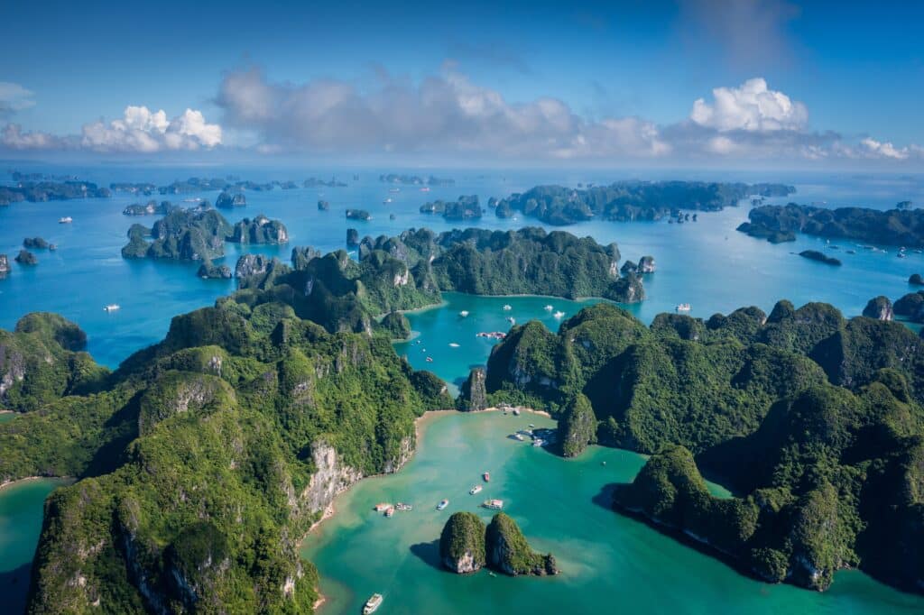
The formations vary in height and density, creating channels and hidden lagoons between them. Geography defines navigation; movement occurs by boat through natural corridors framed by stone. The sea penetrates deeply between islands, blurring boundary between land and water.
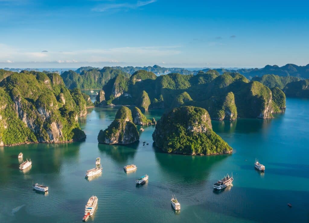
Vegetation clings to vertical rock faces, sustained by thin soil pockets. Geography expresses resilience through adaptation—life persists where surface appears inhospitable. Tides and weather alter light and atmosphere, shifting perception of scale.
Ha Long Bay inspires through fragmentation and unity. The land teaches endurance through erosion, showing how resilience can arise from gradual transformation rather than sudden force. Each pillar reflects slow geological change.
Endurance here is marine and tectonic. Geography combines oceanic movement with limestone dissolution, producing a landscape defined by water shaping stone. Seasonal storms test both vegetation and navigation.
Ha Long Bay reflects a Vietnam where resilience is sculpted by sea interaction with ancient rock. Visitors encounter a landscape that reinforces endurance as balance between permanence and change within coastal waters.
19. Phong Nha–Kẻ Bàng National Park
Phong Nha–Kẻ Bàng lies in central Vietnam near the Laotian border. Geography here is subterranean and karst-dominated. Limestone plateaus conceal one of the world’s most extensive cave systems beneath forested terrain.
Rivers disappear into rock and reemerge kilometers away. Geography shapes hidden networks through dissolution of limestone by flowing water. Towering caverns form chambers large enough to contain forests and underground rivers.
The surface landscape appears densely vegetated, yet beneath it lies a hollowed architecture shaped by time. Geography reinforces duality—visible forest above, cavern system below. Elevation varies gently compared to northern highlands, yet internal vertical space rivals mountain peaks.
Movement through the park alternates between jungle trails and cave exploration. Geography dictates safety and access through seasonal water levels and structural stability of caverns.
The park inspires through revelation. The land teaches endurance through unseen formation, showing how resilience develops quietly within stone over geological epochs. Water shapes structure slowly and persistently.
Endurance here is geological and hydrological. Geography binds rainfall, river flow, and limestone composition into an evolving system that continues to expand underground.
Phong Nha–Kẻ Bàng reflects a Vietnam where resilience forms in concealed spaces beneath forest canopy. Visitors encounter a landscape that reinforces endurance as transformation shaped by water within ancient rock.
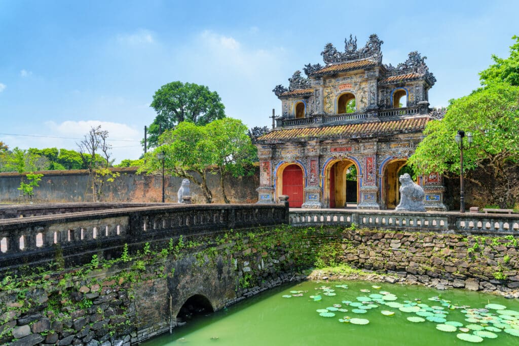
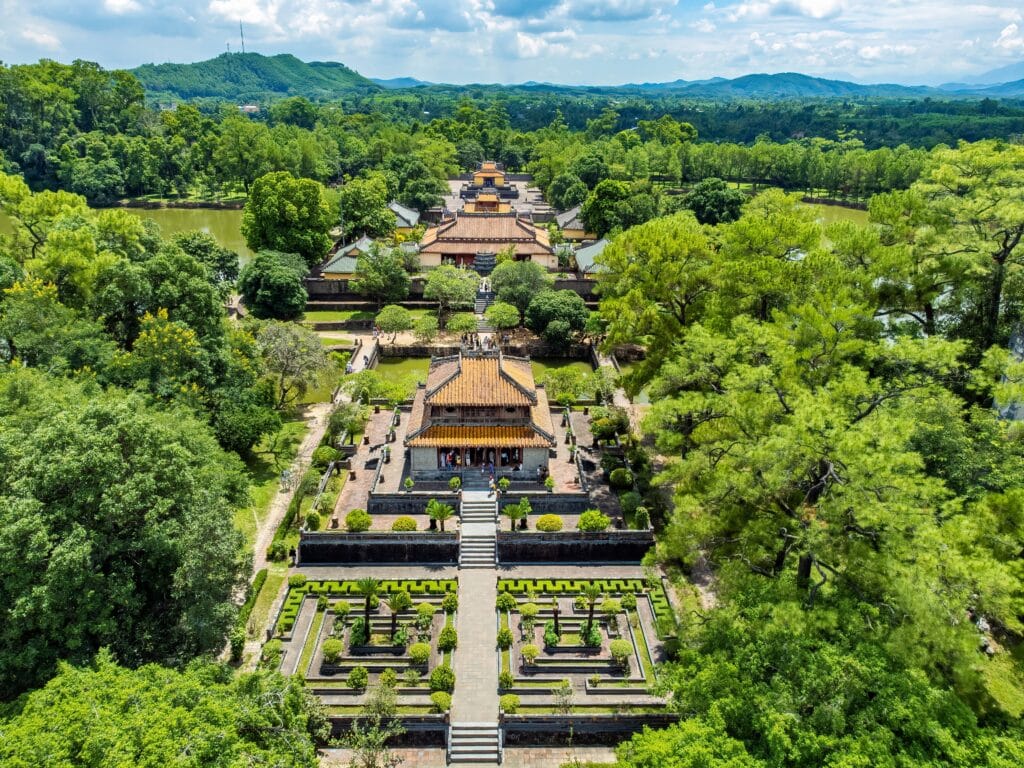
18. Hue

Hue lies in central Vietnam along the Perfume River, positioned between the Annamite foothills and the South China Sea. Geography here is riverine and coastal. The river curves gently through low plains before widening toward a lagoon system near the coast.
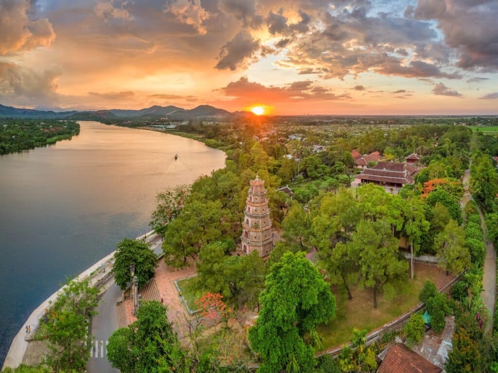
The surrounding terrain is comparatively flat, though hills rise gradually to the west. Geography binds settlement to water flow, reinforcing irrigation and transport through the Perfume River basin. Seasonal monsoon rains influence river level and agricultural rhythm.
The coastline east of Hue consists of barrier islands and shallow lagoons. Geography creates layered water systems—river, lagoon, and sea operating in connected sequence. Floodplains require adaptation to periodic overflow.
Movement through Hue follows riverbanks and coastal corridors. Geography encourages longitudinal travel along Vietnam’s narrow central spine. The surrounding mountains shield the area partially from western winds while channeling rainfall.
Hue inspires through balance between inland elevation and maritime openness. The land teaches endurance through coexistence with seasonal water variation, showing how resilience develops where rivers widen and tides influence inland flow.
Endurance here is hydrological and climatic. Geography demands architectural and agricultural alignment with flood cycles. Stability depends on measured response to monsoon intensity.
Hue reflects a Vietnam shaped by river-sea interaction within central lowlands. Visitors encounter a landscape that reinforces endurance as adaptation to shifting water levels within a narrow coastal corridor.
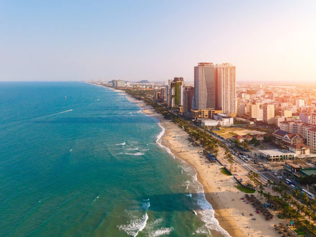
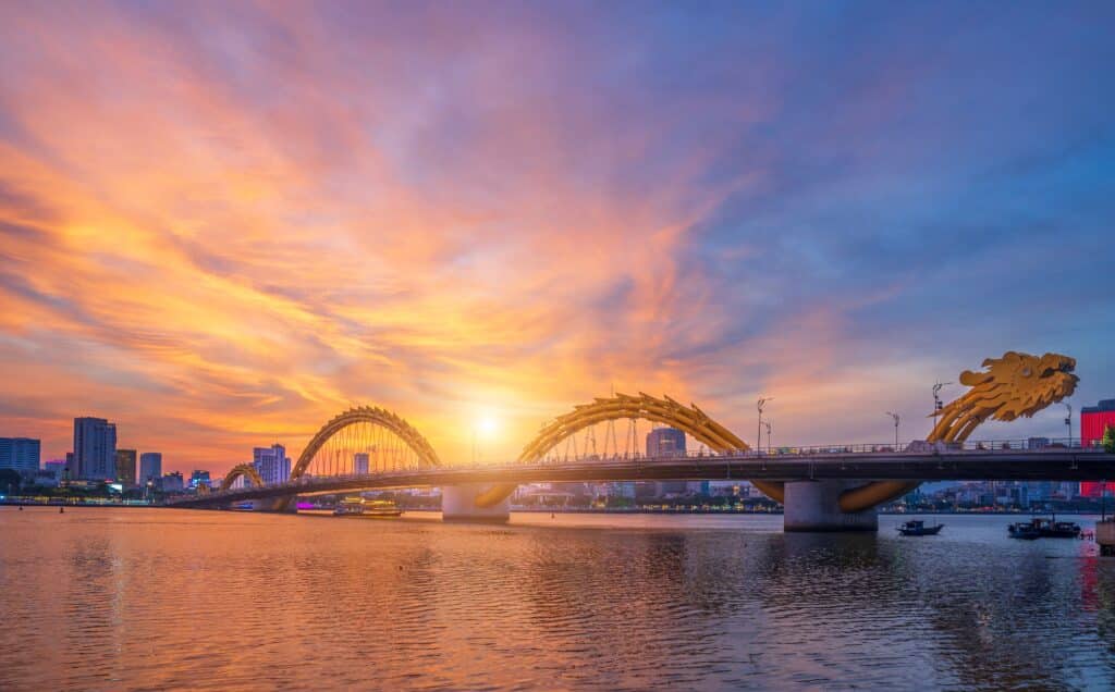
17. Da Nang
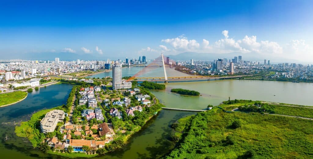
Da Nang occupies a coastal plain in central Vietnam where the Han River meets the sea. Geography here is transitional. Mountains rise immediately west of the city, while sandy beaches extend eastward along the South China Sea.
The Hai Van Pass to the north marks a climatic divide between northern and southern Vietnam. Geography shapes weather patterns through elevation, affecting rainfall and temperature distribution along the coast.
The river basin supports urban expansion across relatively flat terrain. Geography allows outward growth between mountain base and shoreline. Coastal exposure, however, requires preparation for typhoons and seasonal storms.
Movement through Da Nang reflects its position as a coastal corridor hub. Roads and rail lines follow the narrow central strip of land where mountain and sea compress the country’s width.
Da Nang inspires through juxtaposition. The land teaches endurance through balancing coastal vulnerability with mountain protection, showing how resilience forms where geography narrows yet connects regions.
Endurance here is coastal and infrastructural. Geography requires adaptation to storm impact while sustaining maritime and riverine access.
Da Nang reflects a Vietnam where resilience arises from positioning between ridge and sea. Visitors encounter a landscape that reinforces endurance as coexistence with climatic transition zones along the central coast.
16. Mekong Delta
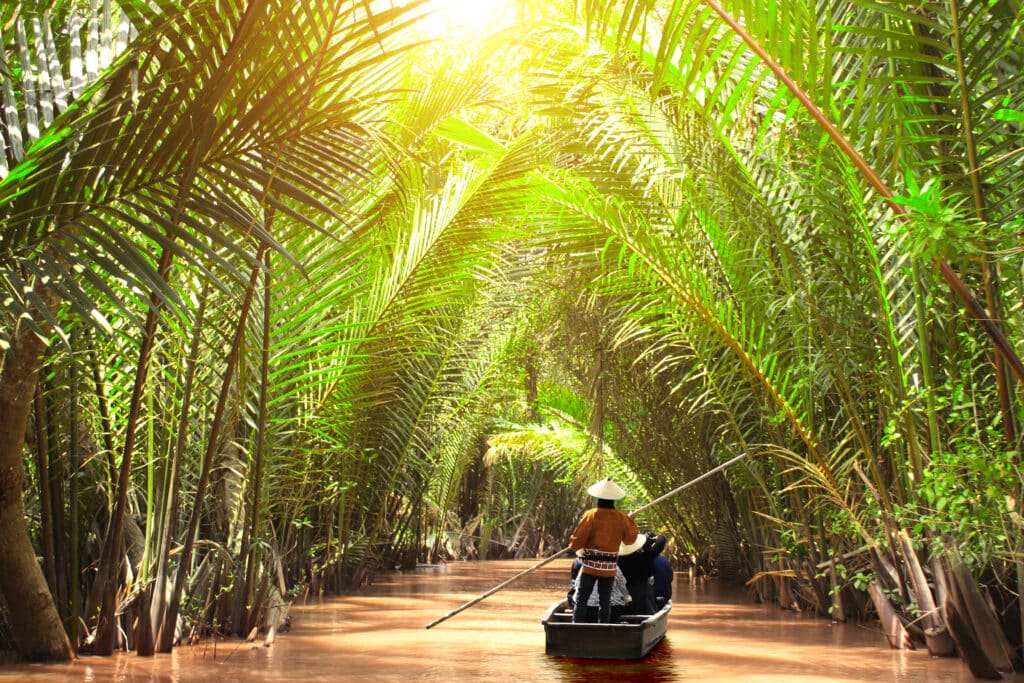
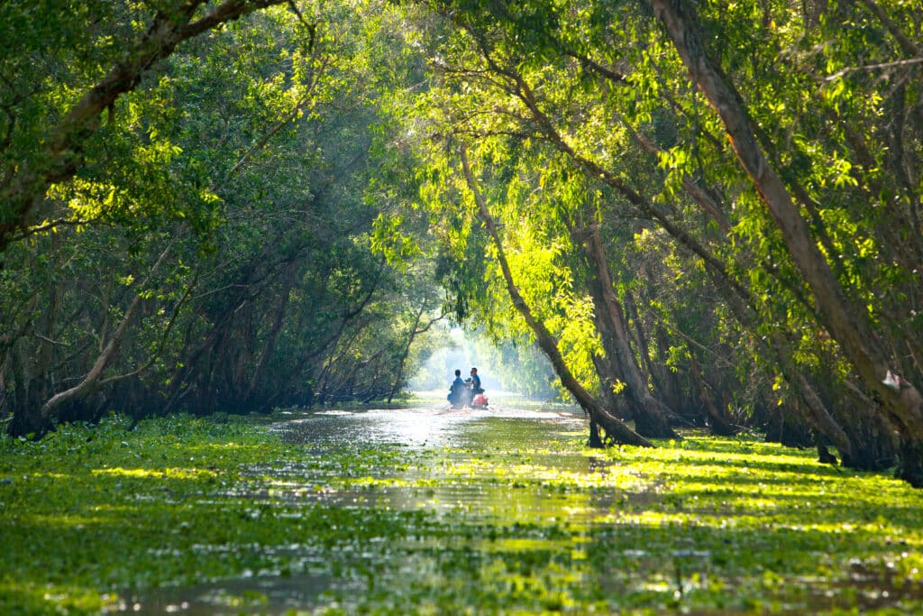
The Mekong Delta spreads across southern Vietnam as a vast network of distributaries, canals, and floodplains where the Mekong River meets the sea. Geography here is sedimentary and fluid. Layers of alluvial soil deposited over centuries create fertile ground across low elevation terrain.
Water dominates the landscape. Rivers branch repeatedly, forming an intricate lattice of channels that define settlement patterns. Geography shapes mobility through boat rather than road in many areas, reinforcing adaptation to aquatic terrain.

The delta remains only slightly above sea level. Geography makes it productive yet vulnerable. Seasonal floods replenish soil but require careful management through dikes and irrigation systems.
Vegetation thrives in this nutrient-rich environment. Rice fields extend across wide plains, interspersed with orchards and floating markets. Geography sustains dense agriculture through constant sediment renewal.
Movement through the Mekong Delta follows natural and constructed waterways. Geography encourages horizontal navigation rather than vertical ascent. Distance is measured along channels rather than across land.
The delta inspires through abundance shaped by water. The land teaches endurance through alignment with river rhythm, showing how resilience develops where flood and fertility coexist.
Endurance here is hydrological and climatic. Geography binds human life to seasonal flow and sea-level interaction. Stability depends on careful stewardship of water systems.
The Mekong Delta reflects a Vietnam where resilience emerges from sediment and tide. Visitors encounter a landscape that reinforces endurance as adaptation within one of Southeast Asia’s most expansive river systems.
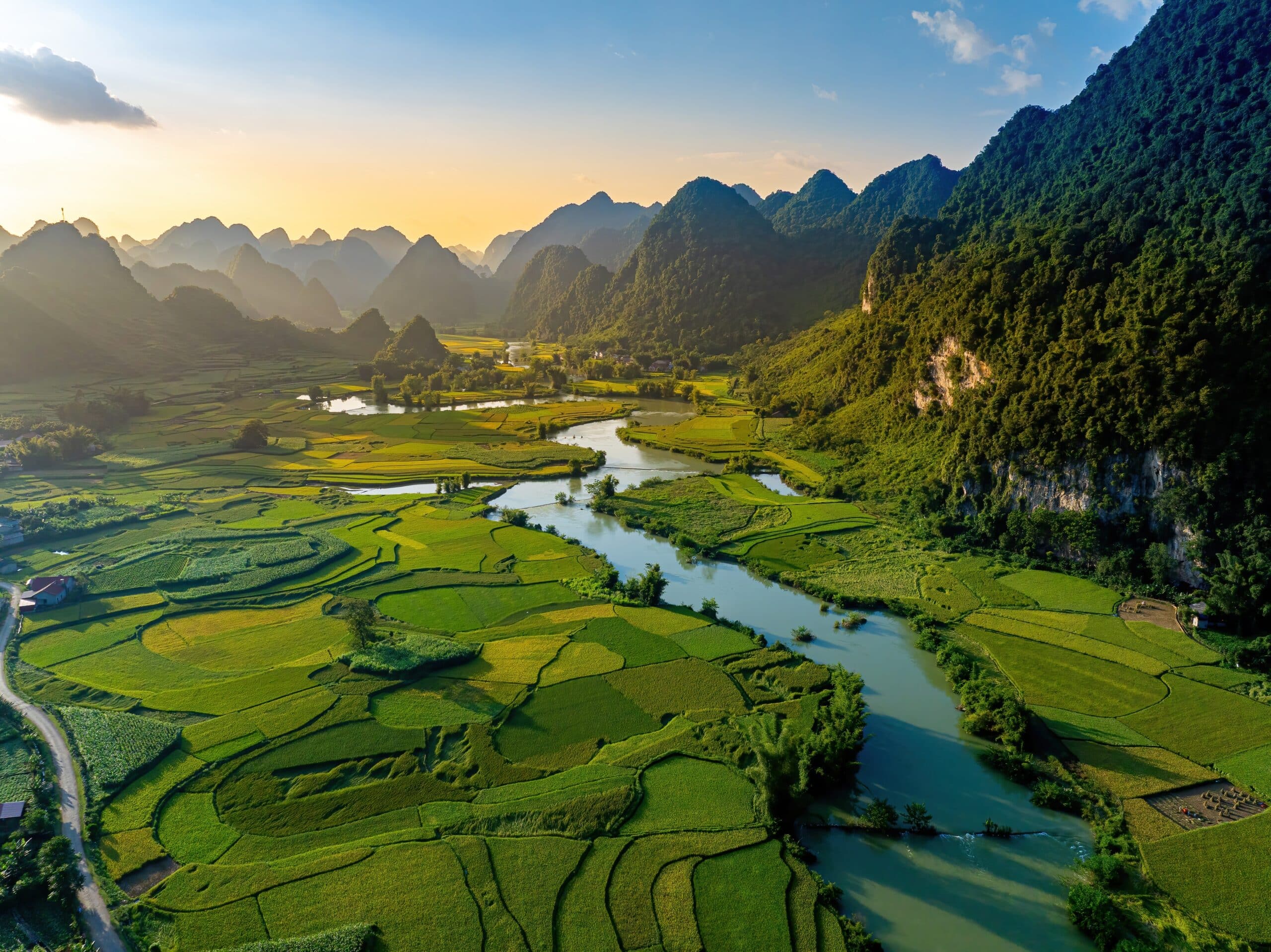
15. Ninh Binh
Ninh Binh lies south of Hanoi within the Red River Delta region, where limestone karst formations rise from flat agricultural plains. Geography here is inland and sculpted by erosion. Towering rock pillars emerge abruptly from rice paddies, forming a terrestrial counterpart to Ha Long Bay’s marine landscape.
Rivers wind between the limestone masses, creating narrow water corridors framed by steep cliffs. Geography shapes movement through lowland channels rather than open plains. Boats glide through caves carved by dissolved limestone, linking enclosed basins.
The surrounding delta provides fertile soil for rice cultivation. Geography combines sedimentary flatland with isolated karst elevation, reinforcing contrast within compact space. Seasonal flooding enriches soil while demanding agricultural timing.
Movement through Ninh Binh follows river bends and footpaths skirting limestone bases. Geography encourages horizontal exploration interrupted by vertical stone outcrops.
Ninh Binh inspires through juxtaposition of openness and enclosure. The land teaches endurance through adaptation to mixed terrain, showing how resilience develops where agriculture coexists with geological prominence.
Endurance here is fluvial and sedimentary. Geography binds rice cultivation to river flow while limestone formations stand as markers of deep geological time.
Ninh Binh reflects a Vietnam where resilience is expressed through harmony between fertile delta and karst elevation. Visitors encounter a landscape that reinforces endurance as coexistence between water-fed plains and stone formations shaped over millennia.
14. Hoi An
Hoi An rests along Vietnam’s central coast near the Thu Bon River estuary. Geography here is estuarine and coastal. The river broadens before meeting the sea, forming fertile banks and sheltered anchorages.
The surrounding terrain is relatively flat, framed by distant hills. Geography supports agriculture inland while maritime access encourages exchange along the shoreline. Sandbars and tidal shifts shape river mouth navigation.
Seasonal monsoons influence both river level and coastal currents. Geography reinforces adaptation to flood cycles and storm exposure. Elevated foundations and compact urban design reflect awareness of water fluctuation.
Movement through Hoi An follows riverbanks and coastal roads within Vietnam’s narrow central corridor. Geography allows connectivity while maintaining distinct river-sea interaction.
Hoi An inspires through equilibrium between land and tide. The land teaches endurance through alignment with estuarine rhythm, showing how resilience forms where freshwater and saltwater converge.
Endurance here is hydrological and maritime. Geography requires balancing river management with coastal protection. Stability depends on measured response to seasonal water variation.
Hoi An reflects a Vietnam shaped by estuary geography within a compressed coastal strip. Visitors encounter a landscape that reinforces endurance as adaptation to both inland river flow and maritime influence.
13. Dalat
Dalat lies in Vietnam’s Central Highlands at an elevation of roughly 1,500 meters. Geography here is elevated and temperate. Rolling hills, pine forests, and plateau terrain distinguish the region from humid coastal lowlands.
The highland plateau moderates temperature, creating cooler conditions than much of southern Vietnam. Geography influences agricultural production, supporting crops suited to mild climate and well-drained volcanic soil.
Lakes and waterfalls punctuate the surrounding hills. Geography shapes water flow through cascading streams descending toward lower basins. The plateau’s undulating terrain encourages dispersed settlement rather than dense urban clustering.
Movement through Dalat follows winding roads across ridges and valleys. Geography reinforces awareness of elevation change without abrupt mountain confinement. The landscape feels expansive yet elevated.
Dalat inspires through climatic contrast. The land teaches endurance through adaptation to altitude, showing how resilience develops where geography offers relief from tropical heat while requiring adjustment to thinner air and cooler nights.
Endurance here is ecological and climatic. Geography binds vegetation patterns to elevation and rainfall distribution. Soil composition supports sustained cultivation within plateau conditions.
Dalat reflects a Vietnam where resilience emerges from highland variation within a predominantly coastal country. Visitors encounter a landscape that reinforces endurance as coexistence between rolling elevation, forest cover, and temperate climate shaped by altitude.
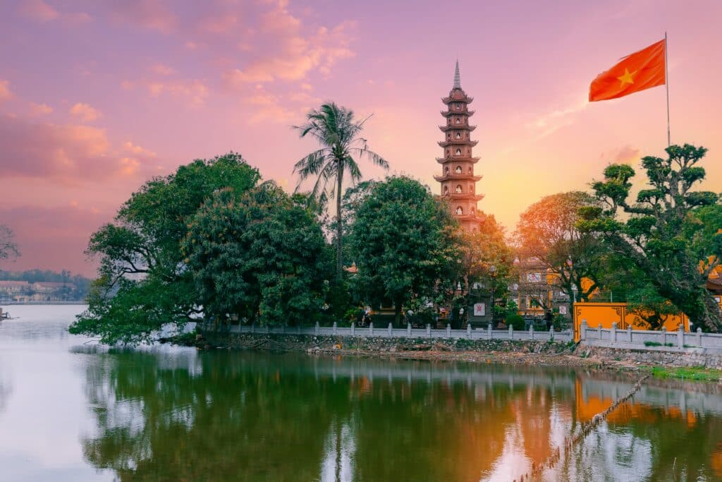
12. Hanoi

Hanoi lies in northern Vietnam within the Red River Delta, positioned along the western bank of the Red River. Geography here is fluvial and low-lying. The delta’s sedimentary soil, deposited over centuries, forms a fertile foundation for dense settlement.
The river system branches across the plain, creating a network of waterways that shape agriculture and urban expansion. Geography reinforces proximity to water as essential for cultivation and transportation. Seasonal flooding historically influenced settlement patterns and infrastructure design.
The surrounding terrain remains largely flat, though low hills rise gradually to the north and west. Geography encourages horizontal growth rather than vertical adaptation. Lakes scattered throughout the city are remnants of ancient river channels, integrating water directly into urban form.

Movement through Hanoi follows both river corridors and longitudinal transport routes that connect northern highlands to the coast. Geography positions the city as a transition point between mountainous interior and delta plain.
Hanoi inspires through continuity with water. The land teaches endurance through alignment with river rhythm, showing how resilience develops where seasonal flood cycles shape habitation.
Endurance here is hydrological and sedimentary. Geography binds life to fertile soil replenished by upstream mountain runoff. Stability depends on managing river behavior within expanding settlement.
Hanoi reflects a Vietnam where resilience grows from river-fed plains at the country’s northern gateway. Visitors encounter a landscape that reinforces endurance as coexistence with delta waters and fertile sediment.
11. Con Dao Islands
The Con Dao Islands lie off Vietnam’s southern coast in the South China Sea. Geography here is insular and maritime. Granite hills rise from surrounding waters, forming a compact archipelago shaped by oceanic forces.
The main island features forested slopes descending to sandy coves. Geography emphasizes isolation, as distance from the mainland reinforces ecological distinction. Coral reefs fringe portions of the coastline, shaped by warm currents and clear water.
Rainfall patterns and sea winds influence vegetation density. Geography binds terrestrial and marine systems closely together. Elevation remains modest compared to mainland mountains, yet steep gradients define interior terrain.
Movement across Con Dao follows coastal roads and footpaths tracing hillside contours. Geography restricts expansion through limited flat land while offering broad sea horizons.
The islands inspire through separation. The land teaches endurance through adaptation to insular conditions, showing how resilience develops where freshwater availability and maritime exposure require balance.
Endurance here is marine and ecological. Geography links forest cover to rainfall cycles while reefs depend on water clarity and temperature stability.
Con Dao reflects a Vietnam where resilience emerges from island geography shaped by sea and wind. Visitors encounter a landscape that reinforces endurance as coexistence between granite highlands and surrounding ocean.
10. Pu Luong Nature Reserve
Pu Luong lies southwest of Hanoi within northern Vietnam’s limestone highlands. Geography here is mountainous and terraced. Steep valleys cut through forested ridges, forming enclosed basins suited for small-scale agriculture.
Rice terraces contour valley slopes, shaped incrementally to follow natural gradients. Geography dictates careful water distribution through gravity-fed channels. Streams descend from higher elevations, sustaining cultivation in narrow floor plains.
The surrounding karst formations resemble those of Ninh Binh but are more expansive and less concentrated. Geography reinforces rural isolation through winding mountain roads and limited flat expanses.
Vegetation thrives in humid subtropical climate, influenced by monsoon rains. Geography binds forest preservation to watershed protection, ensuring stability of irrigation systems.
Movement through Pu Luong follows ridge-top paths and valley crossings. Geography emphasizes vertical transition between forest canopy and cultivated fields. Travel remains slower than in delta regions, reinforcing scale awareness.
Pu Luong inspires through measured adaptation. The land teaches endurance through cooperation with elevation, showing how resilience forms where agriculture integrates directly into mountainous structure.
Endurance here is ecological and hydrological. Geography requires preservation of forested slopes to prevent erosion and protect water flow. Stability depends on maintaining balance between cultivation and conservation.
Pu Luong reflects a Vietnam where resilience emerges from mountain agriculture within protected landscapes. Visitors encounter a terrain that reinforces endurance as alignment between slope, water, and forest ecology.
9. Phu Quoc
Phu Quoc lies in the Gulf of Thailand off Vietnam’s southwestern coast. Geography here is insular and gently mountainous. The island’s interior consists of forested hills, while its perimeter is defined by sandy beaches and shallow coastal waters.
Elevation rises modestly toward the central spine, where tropical forest remains relatively intact. Geography reinforces ecological separation from the mainland, with marine currents shaping shoreline character and reef development.
Rainfall patterns vary seasonally, with monsoon winds influencing wave direction and coastal erosion. Geography binds freshwater availability to interior streams that descend from hill slopes toward the sea.
Movement across Phu Quoc follows a coastal loop road and smaller inland routes that wind through forested terrain. Geography encourages peripheral settlement along flatter shorelines while maintaining a quieter interior.
The island inspires through moderated scale. The land teaches endurance through balance between marine exposure and forest protection, showing how resilience develops where sea and hill meet within confined territory.
Endurance here is coastal and ecological. Geography requires protection of watershed forests to preserve freshwater resources. Stability depends on sustaining reef systems and managing shoreline change.
Phu Quoc reflects a Vietnam where resilience emerges from island adaptation shaped by seasonal wind and surrounding sea. Visitors encounter a landscape that reinforces endurance as coexistence between forested elevation and maritime horizon.
8. Ha Giang
Ha Giang occupies Vietnam’s far northern frontier along the Chinese border. Geography here is rugged and elevated. Limestone peaks rise sharply above deep valleys, forming one of the country’s most dramatic mountain regions.
The terrain is fractured and steep. Geography restricts settlement to narrow valley floors and ridge-top clusters. Terraced fields carve into slopes where gradient allows limited cultivation.
Karst formations dominate much of the region, creating jagged silhouettes and hidden ravines. Geography reinforces isolation through winding mountain roads and high passes that require careful navigation.
Elevation produces cooler temperatures and occasional winter frost. Geography shapes microclimates within short distances, influencing crop selection and vegetation cover.
Movement through Ha Giang follows serpentine routes tracing ridgelines and descending into valleys. Geography emphasizes vertical change, reinforcing awareness of altitude and exposure.
Ha Giang inspires through extremity. The land teaches endurance through adaptation to steep gradient and limited arable land, showing how resilience forms where terrain demands precision rather than expansion.
Endurance here is topographic and climatic. Geography requires terrace maintenance and soil conservation to prevent erosion. Stability depends on aligning agriculture with natural slope.
Ha Giang reflects a Vietnam where resilience is forged in mountainous borderlands shaped by limestone uplift and narrow cultivation zones. Visitors encounter a landscape that reinforces endurance as adaptation within elevated karst terrain.
7. Mui Ne
Mui Ne lies along Vietnam’s southeastern coastline near Phan Thiet. Geography here is coastal and semi-arid. Sand dunes stretch inland from the sea, shaped continuously by wind patterns.
Unlike much of Vietnam’s humid landscape, this region experiences relatively lower rainfall. Geography reinforces dune mobility through seasonal wind intensity. Red and white sand formations rise in sculpted ridges that shift subtly over time.
The coastline alternates between sandy beaches and rocky segments. Geography binds marine exposure to dune formation, linking ocean currents and wind direction.
Movement through Mui Ne follows coastal roads skirting the shoreline. Geography allows relatively easy transit compared to mountainous regions, yet interior dunes remain difficult to cross directly.
Mui Ne inspires through contrast within the national landscape. The land teaches endurance through adaptation to wind-shaped terrain, showing how resilience develops where aridity interrupts tropical humidity.
Endurance here is aeolian and coastal. Geography depends on balance between vegetation stabilization and natural dune movement. Stability requires measured interaction with fragile sandy ecosystems.
Mui Ne reflects a Vietnam where resilience emerges from wind-sculpted coastal plains. Visitors encounter a landscape that reinforces endurance as coexistence between shifting sand and open sea.
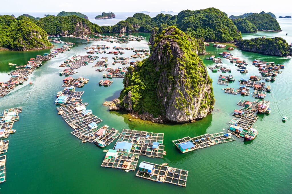
6. Cat Ba Island
Cat Ba Island lies at the southern edge of Ha Long Bay in northern Vietnam. Geography here is insular and karst-dominated. Limestone hills rise steeply from the sea, forming a rugged interior covered with dense forest.
The island’s coastline alternates between rocky cliffs and sheltered coves. Geography shapes access through narrow inlets and small sandy beaches tucked between stone outcrops. Tidal variation influences shoreline exposure throughout the day.
Cat Ba’s terrain is more expansive than individual karst pillars offshore, allowing for interior trails across undulating hills. Geography binds marine and terrestrial ecosystems closely together, with mangroves and coral systems present along parts of the coast.
Rainfall follows northern monsoon patterns, sustaining vegetation across limestone slopes. Geography requires soil retention on steep gradients, reinforcing forest cover as a stabilizing element.
Movement across Cat Ba follows winding roads and hiking paths navigating elevation change. Geography emphasizes slope and curvature rather than flat continuity.
Cat Ba inspires through contained wilderness. The land teaches endurance through adaptation to rocky substrate and maritime climate, showing how resilience develops where forest anchors limestone terrain against coastal wind and rain.
Endurance here is ecological and marine. Geography integrates tidal flow, forest preservation, and karst elevation into a unified island system.
Cat Ba reflects a Vietnam where resilience is shaped by interaction between limestone uplift and surrounding sea. Visitors encounter a landscape that reinforces endurance as balance between rugged elevation and protected coastal waters.
5. Ba Be National Park
Ba Be National Park lies in northeastern Vietnam within a mountainous limestone region. Geography here is freshwater-centered and elevated. At its core rests Ba Be Lake, one of the country’s largest natural lakes, surrounded by forested karst peaks.
The lake occupies a depression formed by geological movement and erosion. Geography shapes a calm basin framed by steep slopes descending directly into water. Rivers and streams feed the lake before continuing through underground channels.
Dense forest covers much of the surrounding terrain. Geography reinforces biodiversity through varied elevation and abundant rainfall. Soil remains thin across limestone slopes, encouraging preservation of vegetation to prevent erosion.
Movement through Ba Be follows lake crossings by boat and narrow mountain roads connecting remote valleys. Geography encourages aquatic transit across the central basin while limiting rapid overland expansion.
Ba Be inspires through contained stillness. The land teaches endurance through hydrological balance, showing how resilience develops where freshwater stability depends on surrounding forest protection.
Endurance here is ecological and fluvial. Geography binds lake level to seasonal rainfall and watershed integrity. Stability relies on careful stewardship of upland slopes.
Ba Be reflects a Vietnam where resilience emerges from the harmony between mountain basin and freshwater core. Visitors encounter a landscape that reinforces endurance as coexistence between limestone elevation and tranquil lake surface.
4. Quy Nhon
Quy Nhon lies along Vietnam’s south-central coast, positioned between low coastal plains and modest inland hills. Geography here is coastal and semi-enclosed. A curved bay shelters the shoreline, reducing direct wave exposure compared to more open stretches of coast.
Rocky headlands frame sandy beaches, creating segmented coastal pockets. Geography shapes settlement along flatter land near the water, while inland hills limit horizontal expansion.
The climate follows central Vietnam’s seasonal rainfall pattern, with periods of heavy precipitation and dry intervals. Geography binds agricultural activity to nearby river valleys that descend toward the sea.
Movement through Quy Nhon follows the coastal corridor linking northern and southern provinces. Geography reinforces linear transit along Vietnam’s narrow midsection.
Quy Nhon inspires through measured openness. The land teaches endurance through adaptation to coastal rhythm, showing how resilience develops where protected bays moderate maritime forces.
Endurance here is coastal and climatic. Geography requires preparation for seasonal storms while benefiting from sheltered inlets that reduce erosion intensity.
Quy Nhon reflects a Vietnam where resilience forms along curved shoreline shaped by modest elevation and steady sea interaction. Visitors encounter a landscape that reinforces endurance as balance between coastal exposure and natural protection.
3. Phong Nha–Ke Bang National Park
Phong Nha–Ke Bang National Park lies in central Vietnam near the Laotian border. Geography here is karstic and cavernous. Vast limestone formations dominate the terrain, pierced by some of the world’s largest cave systems.
The landscape consists of dense forest layered over fractured limestone bedrock. Geography shapes underground rivers that carve immense caverns through slow dissolution. Sinkholes and vertical shafts punctuate the surface.
Rivers such as the Son River disappear into cave mouths and reemerge downstream. Geography reinforces subterranean flow patterns uncommon in flatter regions. Surface topography appears rugged yet conceals extensive voids beneath.
Rainfall sustains tropical forest cover that stabilizes fragile limestone slopes. Geography binds ecosystem health to watershed protection, as erosion can disrupt underground channels.
Movement through the park alternates between river navigation and trekking across uneven terrain. Geography emphasizes vertical descent into caverns and gradual ascent along forested ridges.
Phong Nha inspires through geological scale. The land teaches endurance through deep time, showing how resilience forms across millennia of erosion and uplift.
Endurance here is subterranean and hydrological. Geography requires conservation of both visible forest and hidden cave systems. Stability depends on protecting the relationship between rainfall and underground watercourses.
Phong Nha–Ke Bang reflects a Vietnam where resilience is written in stone and darkness beneath forest canopy. Visitors encounter a landscape that reinforces endurance as coexistence between surface wilderness and cavernous depth.
2. Can Tho
Can Tho lies in the heart of the Mekong Delta in southern Vietnam. Geography here is fluvial and low-lying. The land consists of sediment deposited by the Mekong River as it divides into distributaries before reaching the sea.
Channels branch extensively, forming a lattice of waterways. Geography defines daily life through river transport and floating exchange points. Soil remains fertile due to annual sediment replenishment.
The terrain is nearly flat, with minimal elevation variation. Geography reinforces dependence on river flow for irrigation and transportation. Seasonal flooding shapes agricultural timing and infrastructure placement.
Movement through Can Tho occurs primarily by boat along interconnected canals. Geography encourages aquatic mobility rather than overland transit.
Can Tho inspires through fluid continuity. The land teaches endurance through alignment with river rhythm, showing how resilience develops where water dominates terrain.
Endurance here is sedimentary and seasonal. Geography requires adaptation to fluctuating water levels while preserving fertile delta soil. Stability depends on managing upstream flow and local canal networks.
Can Tho reflects a Vietnam where resilience emerges from one of the world’s great river systems. Visitors encounter a landscape that reinforces endurance as coexistence between human settlement and expansive delta waterways.
1. Sapa
Sapa lies in northwestern Vietnam within the Hoang Lien Son mountain range. Geography here is elevated and terraced. Peaks rise dramatically above cloud-filled valleys, including the country’s highest summit, Fansipan.
The terrain is steep and layered. Geography restricts flat land to narrow valley floors where rice terraces contour hillsides. These terraces follow natural gradient, maximizing cultivation within limited arable space.
Mist frequently envelops the region due to altitude and moisture convergence. Geography shapes microclimates that differ from lowland tropics. Cooler temperatures influence vegetation patterns and seasonal cycles.
Rivers descend rapidly from mountain slopes toward the Red River basin. Geography reinforces watershed significance and soil conservation necessity to prevent erosion.
Movement through Sapa follows winding mountain roads and footpaths crossing ridges and terraces. Geography emphasizes vertical progression and sweeping valley views.
Sapa inspires through elevation and precision. The land teaches endurance through adaptation to steep gradient, showing how resilience forms where cultivation must align exactly with slope and rainfall.
Endurance here is topographic and climatic. Geography demands terrace maintenance and careful water channeling. Stability depends on balancing agricultural activity with mountain ecosystem preservation.
Sapa reflects a Vietnam where resilience rises from highland terrain shaped by altitude and seasonal mist. Visitors encounter a landscape that reinforces endurance as coexistence between mountain height and cultivated valley depth.