
Iraq occupies a pivotal geographic position in Western Asia, bridging the Arabian Peninsula, the Anatolian highlands, and the Iranian Plateau. Its landscape is defined by the historic basin of the Tigris and Euphrates Rivers, which converge in southern Iraq before flowing into the Persian Gulf. Geography here is overwhelmingly fluvial in the center and south, mountainous in the north, and desert in the west.
The country’s central and southern plains form part of ancient Mesopotamia — one of the world’s earliest cradles of civilization. These fertile alluvial lowlands were shaped by millennia of river sediment deposition, creating agricultural abundance in stark contrast to the surrounding arid regions. Seasonal flooding historically dictated settlement patterns, irrigation systems, and urban development.
Northern Iraq rises into the foothills and rugged peaks of the Zagros Mountains. Geography there is defined by valleys, limestone ridges, and snow-fed streams, producing cooler climates and more varied vegetation. These uplands form natural corridors toward Anatolia and Iran.
Western Iraq transitions into vast desert plateaus extending toward Syria, Jordan, and Saudi Arabia. Sparse rainfall, high evaporation rates, and extreme temperature variation characterize this region. Geography requires adaptation to water scarcity and shifting sand and gravel plains.
Iraq’s geographic diversity — riverine plains, marshlands, mountain highlands, and desert expanses — has shaped its history, culture, and economy for over 6,000 years. Trade routes, empires, and settlements emerged where water and fertile soil permitted stability.
In the chapters ahead, Iraq will be explored through its major geographic regions: the Mesopotamian heartland, the southern marshes, the northern mountains, and the western deserts — revealing a country whose identity remains inseparable from its rivers and terrain.
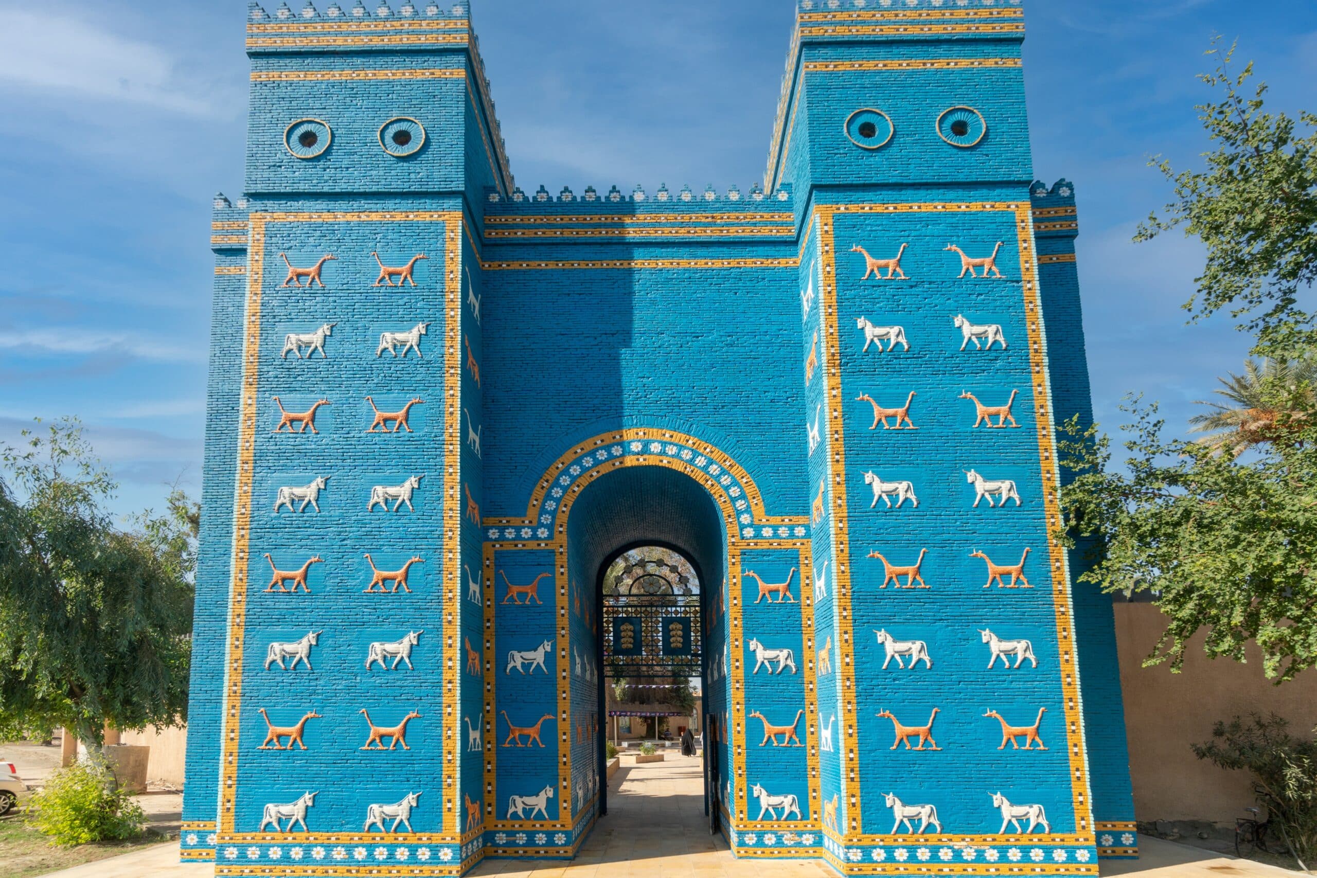
20. Babylon
Babylon lies south of Baghdad on the fertile alluvial plain formed by the Euphrates River. Geography here is lowland floodplain, shaped by millennia of river sediment deposition that created some of the most productive soils in the ancient world.
The Euphrates flows steadily through this central corridor, historically flooding and replenishing farmland with nutrient-rich silt. Geography reinforced early agricultural surplus, enabling the rise of one of humanity’s most influential urban civilizations. Babylon developed along natural river levees slightly elevated above surrounding fields, protecting it from seasonal inundation while maintaining access to irrigation.
The landscape is flat and expansive, with visibility stretching across wide agricultural tracts. Geography required extensive canal systems to regulate water flow — too little water brought drought, too much caused destructive flooding. Ancient engineers constructed intricate irrigation networks that transformed unpredictable river cycles into stable food production.
The climate is hot semi-arid, with scorching summers and mild winters. Geography demanded adaptation through thick mudbrick architecture, shaded courtyards, and water-centered urban planning. Proximity to river transport routes also reinforced Babylon’s role as a commercial and political hub linking northern Mesopotamia to the Persian Gulf.
Endurance here is hydrological and agricultural. The region’s sustainability has always depended on careful water management and soil preservation. Salinization — a long-term challenge in irrigated plains — demonstrates how geography requires balance between cultivation and environmental limits.
Babylon reflects Iraq’s central riverine geography shaped by the Euphrates’ dynamic floodplain. Visitors encounter a landscape where civilization rose directly from fertile sediment and controlled waterways — a powerful testament to how geography forged one of the world’s earliest urban cultures.
19. Erbil Citadel
Erbil Citadel rises above the modern city of Erbil in northern Iraq’s Kurdistan Region. Geography here transitions from the Mesopotamian plain into the foothills of the Zagros Mountains, creating gently rolling terrain fed by seasonal streams.
The citadel itself stands atop an artificial tell — a mound formed by thousands of years of layered settlement. Geography reinforced its strategic value: elevated ground offered visibility across surrounding plains and protection from potential invasion. From its summit, one can observe agricultural fields stretching outward toward low ridges and distant mountains.
Northern Iraq’s climate is more temperate than the south, with cooler winters and modest rainfall. Geography supports mixed agriculture — wheat fields, orchards, and grazing lands — sustained by rainfall rather than large-scale river irrigation. Snowfall in higher Zagros elevations feeds seasonal runoff that enriches valley soils.
The citadel’s circular form reflects settlement constrained by topography. Buildings cluster tightly within protective outer walls, while steep slopes surrounding the mound enhance natural defense. Geography influenced urban density and fortification design.
Endurance here is geological and climatic. The mound’s layered composition reveals how continuous habitation adapted to shifting empires and environmental conditions. Preservation requires careful stabilization of earthen slopes vulnerable to erosion.
Erbil Citadel reflects Iraq’s northern transitional geography — between plains and mountains — where elevated tells offered security and agricultural valleys sustained life. Visitors encounter a living archaeological landscape shaped by elevation, seasonal rainfall, and centuries of adaptation at the edge of Mesopotamia and the Zagros foothills.
18. Mesopotamian Marshes
Mesopotamian Marshes spread across southern Iraq where the Tigris and Euphrates converge before entering the Persian Gulf. Geography here is deltaic wetland, shaped by river bifurcation, sediment accumulation, and seasonal flooding.
The marshes consist of vast reed beds, shallow lakes, and interconnected waterways. Geography reinforces biodiversity: freshwater mixing with brackish tidal influence creates dynamic ecosystems supporting migratory birds, fish populations, and traditional water buffalo grazing.
These wetlands form part of the larger alluvial plain, where rivers lose speed and deposit sediment before reaching the Gulf. Historically, fluctuating water levels determined settlement and movement. Marsh Arab communities built floating reed houses and navigated by canoe, adapting architecture and transport to amphibious terrain.
The climate is hot and humid in summer, with moderate winter temperatures. Geography demands resilience to both drought and excessive water diversion upstream. Changes in river flow dramatically alter wetland extent, demonstrating the delicate balance between hydrology and ecosystem stability.
Endurance here is ecological and hydrological. Sustainable water management upstream in Turkey, Syria, and Iraq directly influences marsh survival. Conservation efforts seek to maintain sufficient freshwater inflow to preserve biodiversity and cultural heritage.
The Mesopotamian Marshes reflect Iraq’s southern delta geography — a landscape defined not by stone or desert, but by water and reeds. Visitors encounter an environment where rivers dissolve into wetlands, illustrating how life adapts where land and water continually merge.
17. Hatra
Hatra lies in northern Iraq’s Nineveh Governorate, west of Mosul, within a semi-arid steppe landscape that transitions toward the Syrian Desert. Geography here is open plateau marked by sparse vegetation, rolling plains, and seasonal wadis that carry rainwater during winter months.
The region sits between the Tigris River basin to the east and the broader desert expanse to the west. Geography reinforced Hatra’s strategic importance as a caravan city positioned along trade routes linking Mesopotamia with the Levant and Arabia. The flat terrain allowed long-distance visibility, offering defensive advantages and early detection of approaching caravans or armies.
Hatra developed in the 2nd and 3rd centuries CE as a fortified city under the Parthian Empire. Its massive circular walls and monumental temples were constructed from local limestone, reflecting adaptation to available geological materials. Geography influenced building orientation, with thick walls moderating extreme summer heat and protecting against desert winds.
The climate is hot and dry, with limited rainfall concentrated in winter. Geography required careful water storage systems to sustain urban life in an environment where perennial rivers were absent. Wells and cisterns captured seasonal runoff, allowing settlement stability in otherwise marginal land.
Endurance here is climatic and strategic. The site’s survival depended on balancing desert isolation with trade connectivity. Today, preservation efforts must address erosion, wind exposure, and the fragile condition of stone structures in an exposed plateau environment.
Hatra reflects Iraq’s northern steppe geography shaped by desert margins, caravan routes, and defensive positioning. Visitors encounter a monumental city rising from open plains — a testament to how human resilience flourished at the edge of fertile Mesopotamia and arid desert expanses.
16. Najaf
Najaf stands in central Iraq near the western edge of the Euphrates River plain, where fertile alluvial lands gradually give way to desert plateau. Geography here forms a transitional zone between river-fed agriculture and arid steppe.
The city developed slightly west of the main Euphrates channel, positioned on higher ground that protects it from seasonal flooding. Geography reinforced its stability: proximity to irrigated farmland ensured food supply, while elevation provided dry, secure settlement space.
Najaf lies near the edge of the vast Najaf Sea depression — a seasonal lake basin that fills during periods of heavy rainfall or increased river flow. This shallow basin reflects the broader geomorphology of Iraq’s central plain, shaped by ancient river courses and sediment deposition.
The climate is hot semi-arid, with extremely high summer temperatures. Geography required architectural adaptation through courtyards, shaded streets, and thick masonry walls designed to buffer heat. Water management remains central to regional sustainability, as agricultural productivity depends on controlled irrigation from the Euphrates.
Endurance here is hydrological and climatic. Maintaining balance between desert encroachment and river-based agriculture defines long-term stability. Soil salinity, water diversion upstream, and drought cycles influence the surrounding plain.
Najaf reflects Iraq’s central transitional geography — where riverine fertility meets desert boundary. Visitors encounter a landscape shaped by elevation, irrigation, and climatic extremes, illustrating how settlement patterns in Iraq often emerged at the precise boundary between water abundance and aridity.
15. Samarra
Samarra lies north of Baghdad along the eastern bank of the Tigris River. Geography here is defined by broad river terraces, cultivated floodplains, and semi-arid hinterlands stretching toward desert plateaus.
The Tigris flows steadily past Samarra, depositing sediment that created fertile agricultural zones on both banks. Geography reinforced the city’s historic role as an Abbasid capital in the 9th century CE. Abundant water supported large populations, irrigation systems, and monumental construction.
The surrounding plain is flat but slightly elevated above active flood channels, offering protection from seasonal overflow. Canals branched from the Tigris to irrigate farmland and supply urban districts. Geography required careful hydraulic planning to regulate water distribution while preventing destructive flooding.
Samarra’s most iconic structure, the Great Mosque with its spiral minaret (Malwiya Tower), rises prominently above the plain. The open terrain enhances visibility of such monumental architecture across wide distances. Mudbrick and baked brick construction reflect adaptation to local materials derived from river sediment.
The climate is hot and dry in summer, with cooler winters and limited rainfall. Geography shaped urban design — wide avenues aligned with prevailing winds helped mitigate heat, while river proximity moderated temperature extremes slightly compared to inland desert areas.
Endurance here is fluvial and architectural. The city’s longevity has always depended on Tigris water flow and protection against erosion. Modern conservation must address riverbank stability and climate-related stress on earthen structures.
Samarra reflects Iraq’s central river valley geography shaped by the Tigris’ steady presence. Visitors encounter a landscape where imperial ambition rose directly from fertile river terraces — a powerful illustration of how Iraq’s great cities were forged by water, sediment, and strategic positioning along enduring waterways.
14. Ur
Ur lies in southern Iraq’s Dhi Qar Governorate, near the lower reaches of the Euphrates River. Geography here is flat alluvial plain formed by thousands of years of sediment deposition from the Tigris–Euphrates river system.
In antiquity, Ur stood much closer to the Persian Gulf than it does today. Continuous sediment accumulation gradually pushed the coastline southward, leaving the city inland. Geography therefore reshaped its economic orientation over time — from maritime access to primarily agricultural dependence.
The surrounding terrain is low-lying and historically prone to seasonal flooding. Early inhabitants engineered canals to regulate water distribution, irrigate fields, and sustain urban life. Fertile soils supported grain cultivation, enabling the rise of one of Sumer’s most powerful city-states in the third millennium BCE.
The region’s climate is hot desert, with extremely high summer temperatures and minimal rainfall. Geography required architectural adaptation through thick mudbrick walls and compact urban design that minimized sun exposure. Water management was central to survival, as both scarcity and over-irrigation posed risks, including soil salinity.
The Great Ziggurat of Ur rises prominently from the plain, its elevated platform protecting sacred space from floodwaters while symbolically linking earth and sky. The openness of the surrounding landscape emphasizes its monumental scale.
Endurance here is fluvial and agricultural. The sustainability of settlement depended entirely on controlling river behavior and maintaining soil fertility. Today, preservation faces challenges from erosion, groundwater shifts, and climatic extremes.
Ur reflects Iraq’s southern Mesopotamian geography — a land created by rivers and sustained through irrigation. Visitors encounter a site where civilization emerged directly from alluvial soil, demonstrating how environmental mastery shaped one of humanity’s earliest urban societies.
13. Karbala
Karbala is located in central Iraq west of the Euphrates River, positioned within the transitional zone between fertile river plains and desert plateau. Geography here reflects the delicate boundary between irrigated agriculture and arid hinterland.
Although slightly removed from the main Euphrates channel, Karbala benefits from irrigation networks that extend from the river’s branches. These canals transform otherwise dry terrain into cultivable land, supporting palm groves and farmland surrounding the city.
The broader region consists of flat plains interspersed with shallow depressions formed by ancient river courses. Seasonal rainfall is limited, and summers are intensely hot. Geography requires careful water allocation to prevent desert encroachment and maintain soil productivity.
Karbala’s location slightly above flood-prone zones provided security from seasonal river overflow while remaining close enough to sustain agriculture. This balance between elevation and water access typifies settlement geography across central Iraq.
Endurance here is hydrological and climatic. Long-term stability depends on consistent Euphrates flow, groundwater levels, and protection against salinization — a recurring challenge in irrigated desert margins. Agricultural viability remains directly tied to upstream water management.
Karbala reflects Iraq’s central plain geography where river systems gradually give way to arid landscapes. Visitors encounter a city shaped by irrigation corridors and desert boundaries, illustrating how human settlement in Iraq often occupies the narrow ecological band between fertile river valley and expansive steppe.
12. Amadiya (Amedi)
Amadiya sits dramatically atop a flat-topped mountain in northern Iraq’s Kurdistan Region, near the Turkish border. Geography here is mountainous, defined by steep valleys, limestone ridges, and highland plateaus within the Zagros range.
The town occupies a natural mesa rising approximately 1,400 meters above sea level. Sheer cliffs encircle the settlement, creating a naturally fortified position. Geography reinforced defensive advantages, as access is limited to narrow approaches carved into the rock.
Surrounding valleys are fed by snowmelt from higher peaks. Seasonal streams nourish orchards and terraced agriculture below the plateau. Compared to Iraq’s southern plains, this region experiences cooler winters and moderate rainfall, supporting more diverse vegetation.
The mountainous terrain historically shaped trade and migration routes through narrow passes linking Mesopotamia to Anatolia. Amadiya’s elevated position allowed oversight of these corridors, enhancing its strategic value.
Geology plays a central role in the town’s character. Limestone formations create dramatic cliff faces and rugged terrain, while fertile valley floors below contrast with the stark rock summit. Architecture adapts to limited plateau space, with tightly arranged buildings maximizing available land.
Endurance here is topographical and climatic. The high elevation offers natural protection but requires adaptation to winter snowfall and limited expansion space. Preservation must address erosion of cliff edges and seismic vulnerability common in tectonically active mountain belts.
Amadiya reflects Iraq’s northern highland geography — a striking contrast to the flat Mesopotamian plains. Visitors encounter a settlement seemingly suspended above valleys, demonstrating how elevation, geology, and mountain climate shaped a distinct cultural landscape within Iraq’s diverse terrain.
11. Ctesiphon (Taq Kasra)
Ctesiphon lies southeast of Baghdad along the eastern bank of the Tigris River. Geography here is classic Mesopotamian river plain — flat, fertile, and shaped by centuries of fluvial deposition.
The Tigris provided both irrigation and transportation, reinforcing Ctesiphon’s rise as the winter capital of the Parthian and later Sassanian Empires. The surrounding alluvial soils supported extensive agriculture, sustaining a large imperial population. Geography allowed canal construction branching from the river, distributing water across cultivated lands.
The site’s most prominent remnant, the monumental arch known as Taq Kasra, stands on slightly elevated ground above the active floodplain. This positioning protected core structures from seasonal river overflow while maintaining proximity to waterways essential for trade and supply.
The climate is hot semi-arid, with extremely warm summers and limited rainfall. Geography required thick brick construction made from riverine clay, a material abundant in the floodplain. Urban planning adapted to intense heat through enclosed courtyards and ventilation corridors.
Endurance here is fluvial and architectural. Stability depended on river management and the maintenance of irrigation networks. Over time, shifts in Tigris channels and sediment buildup altered the surrounding landscape, contributing to the city’s decline.
Ctesiphon reflects Iraq’s central river valley geography, where imperial power emerged directly from agricultural abundance and water access. Visitors encounter a monumental arch rising from open plains — a reminder that Mesopotamian empires were fundamentally shaped by river systems and the fertile terrain they created.
10. Nineveh
Nineveh is located on the eastern bank of the Tigris River opposite modern Mosul in northern Iraq. Geography here transitions from broad river plains to gently rising foothills that lead toward the Zagros Mountains.
The Tigris flows steadily past Nineveh, depositing fertile sediment along its banks. This agricultural richness supported the Assyrian Empire’s capital in the first millennium BCE. Geography reinforced defensive strength: the city’s walls enclosed elevated ground overlooking the river, combining natural and constructed fortification.
Northern Iraq’s climate is more temperate than the south, with modest winter rainfall and cooler seasonal variation. Geography supports mixed farming — cereals, orchards, and livestock — sustained partly by rainfall rather than exclusive canal irrigation.
The site sits at a crossroads between Anatolia, the Levant, and central Mesopotamia. River transport and overland routes converged here, enhancing Nineveh’s strategic importance. The surrounding plains offered space for expansion, while nearby hills provided stone and building materials.
Endurance here is fluvial and strategic. Control of river crossings and fertile hinterlands determined the city’s power. Preservation today faces erosion from weather exposure and urban encroachment from nearby Mosul.
Nineveh reflects Iraq’s northern riverine geography shaped by the Tigris and transitional uplands. Visitors encounter expansive ruins spread across fertile plains, illustrating how imperial capitals rose where rivers, trade corridors, and defensible terrain converged.
9. Al-Ukhaidir Fortress
Al-Ukhaidir Fortress stands in Iraq’s western desert southwest of Karbala. Geography here is arid plateau characterized by gravel plains, sparse vegetation, and wide horizons stretching toward the Syrian and Arabian deserts.
Unlike Iraq’s riverine cities, Al-Ukhaidir was constructed far from major watercourses. Geography emphasizes isolation: the fortress occupies open desert terrain where visibility extends for kilometers in all directions. This setting enhanced defensive awareness and controlled caravan movement across desert trade routes.
Built in the 8th century during the Abbasid period, the fortress was positioned near ancient desert tracks linking Mesopotamia with the Arabian Peninsula. Geography reinforced its function as both defensive outpost and caravanserai, protecting trade across otherwise inhospitable land.
Water supply depended on wells and cisterns that captured limited rainfall and groundwater. In this hyper-arid environment, water management determined survival. Thick limestone walls moderated interior temperatures, protecting occupants from intense summer heat and cold winter nights typical of desert climates.
The surrounding plateau experiences minimal rainfall and significant temperature variation. Geography demands resilience against wind erosion and sand accumulation, both of which affect long-term preservation.
Endurance here is climatic and logistical. Stability required careful planning to sustain human presence in a water-scarce environment. Today, conservation efforts focus on protecting stone structures from weathering in an exposed desert setting.
Al-Ukhaidir Fortress reflects Iraq’s western desert geography — starkly different from the fertile river valleys of the east. Visitors encounter a monumental structure rising from empty plains, demonstrating how trade, defense, and survival adapted to the vast arid landscapes that frame Mesopotamia’s historic heartland.
8. Basra
Basra lies in southern Iraq near the confluence of the Tigris and Euphrates rivers, where they merge to form the Shatt al-Arab before emptying into the Persian Gulf. Geography here is deltaic lowland shaped by sediment deposition, tidal influence, and dense river networks.
The surrounding terrain is flat and water-rich compared to Iraq’s interior. Palm groves line irrigation canals, and wetlands extend outward toward the Gulf. Geography reinforced Basra’s historic role as Iraq’s primary port city. Its proximity to navigable waterways connected Mesopotamia to maritime trade routes across the Arabian Gulf and the Indian Ocean.
The climate is hot and humid in summer due to maritime influence, contrasting with the drier heat of inland regions. Geography creates brackish water zones where freshwater from upstream meets saltwater tides. This mixing shapes agriculture, fisheries, and ecosystem dynamics.
Basra’s growth depended on maintaining navigable channels and managing sediment buildup. River shifts and silting have historically altered shipping access, demonstrating how fluvial and coastal processes shape economic viability.
Endurance here is hydrological and coastal. Long-term sustainability depends on river flow levels, tidal balance, and protection against salinity intrusion. Environmental pressures upstream directly influence Basra’s wetlands and palm agriculture.
Basra reflects Iraq’s southern maritime geography — where rivers transition into sea. Visitors encounter a landscape defined by waterways, tidal currents, and fertile delta soils, illustrating how Iraq’s river civilizations ultimately connect to global oceans through this coastal gateway.
7. Kirkuk
Kirkuk is located in northern Iraq between the Tigris River basin and the foothills of the Zagros Mountains. Geography here is transitional steppe, combining rolling plains with nearby upland ridges.
The city stands slightly elevated above surrounding agricultural fields. Seasonal rainfall supports grain cultivation and grazing, distinguishing the region from the irrigation-dependent south. Geography benefits from moderate precipitation compared to central desert areas.
Kirkuk lies near important natural oil fields embedded in sedimentary rock formations formed millions of years ago. The geological structure of folded anticlines within the Zagros foothill belt created hydrocarbon traps that shaped the city’s modern economic importance.
The climate features hot summers and cooler winters, with rainfall concentrated in late autumn and winter months. Geography supports mixed agriculture but requires careful water management to prevent soil degradation.
Endurance here is geological and climatic. Stability relies on sustainable land use and environmental stewardship in a region shaped by both agriculture and resource extraction. Erosion and groundwater management remain important considerations.
Kirkuk reflects Iraq’s northern transitional geography — positioned between river plain and mountain foothill. Visitors encounter a landscape where rolling steppe meets rising highlands, demonstrating how geology and rainfall patterns define settlement beyond the core Mesopotamian valleys.
6. Sinjar Mountains
Sinjar Mountains rise abruptly from the plains of northwestern Iraq near the Syrian border. Geography here is isolated mountain ridge within otherwise flat steppe and semi-desert terrain.
The range stretches roughly east–west, forming a natural barrier across the open plains. Elevations reach over 1,400 meters, creating cooler microclimates compared to surrounding lowlands. Geography reinforces biodiversity pockets, with vegetation more varied than the adjacent arid plains.
Snowfall in winter and seasonal rainfall sustain springs and small agricultural terraces. These water sources historically allowed communities to settle in otherwise water-scarce regions. The mountain slopes provide natural defensive positions overlooking vast open terrain.
Geologically, the Sinjar Mountains consist primarily of limestone formations shaped by tectonic uplift associated with the broader Zagros mountain system. Erosion has carved valleys and steep escarpments, adding to the rugged character of the ridge.
The surrounding plains experience hot summers and limited rainfall, intensifying the contrast between mountain refuge and desert exposure. Geography historically made the range a strategic refuge during periods of conflict due to its elevation and limited access points.
Endurance here is topographical and climatic. The mountains’ survival value lies in their ability to capture rainfall and provide natural protection. Conservation focuses on preventing overgrazing and soil erosion on fragile slopes.
The Sinjar Mountains reflect Iraq’s northwestern highland geography — an elevated island within expansive plains. Visitors encounter dramatic ridgelines rising from flat horizons, illustrating how even modest mountain systems profoundly shape settlement and ecological diversity in Iraq’s varied terrain.
5. Al-Qurnah
Al-Qurnah lies in southern Iraq at the confluence of the Tigris and Euphrates rivers, where they unite to form the Shatt al-Arab. Geography here is low-lying delta plain defined by river junction dynamics, sediment deposition, and branching waterways.
The surrounding terrain is exceptionally flat, with extensive palm groves and irrigation canals nourished by constant freshwater flow. Geography reinforces agricultural productivity, as nutrient-rich silt replenishes soils during seasonal high water. This junction has long been strategically significant because control of converging rivers means control of trade and transport corridors.
Hydrologically, the merging of two major rivers creates shifting channels and wetlands that expand and contract depending on upstream flow. Geography demands careful management of levees and irrigation systems to prevent flooding while sustaining crops.
The climate is hot desert with humid influence from nearby marshes and Gulf tides. Summer temperatures are extreme, but river proximity moderates microclimates slightly compared to inland desert zones.
Endurance here is fluvial and deltaic. Stability depends on maintaining balanced river discharge and preventing salinity intrusion from downstream tidal influence. Environmental changes upstream directly affect water levels and soil fertility.
Al-Qurnah reflects Iraq’s southern confluence geography — where two historic rivers merge into a single maritime artery. Visitors encounter a landscape shaped by sediment, water flow, and agricultural adaptation at one of Mesopotamia’s most hydrologically significant junctions.
4. Rawanduz Canyon
Rawanduz Canyon is located in northern Iraq’s Kurdistan Region near the Zagros Mountains. Geography here is mountainous and deeply incised, characterized by dramatic limestone cliffs carved by river erosion.
The canyon was formed by the Rawanduz River cutting through uplifted rock layers over millions of years. Steep valley walls plunge sharply into narrow gorges, creating one of Iraq’s most striking natural landscapes. Geography emphasizes tectonic uplift combined with fluvial erosion — a hallmark of the Zagros mountain belt.
Elevations exceed 1,000 meters, producing cooler temperatures and higher rainfall than Iraq’s central plains. Snowmelt from surrounding peaks feeds streams that sustain orchards and terraced agriculture in valley floors. Vegetation is denser than in southern regions, reflecting a more temperate microclimate.
The surrounding terrain consists of folded sedimentary rock, a result of collision between the Arabian and Eurasian tectonic plates. These geological forces shaped ridges, valleys, and dramatic escarpments visible throughout the region.
Endurance here is geological and hydrological. The canyon continues to evolve as water carves through limestone, slowly reshaping cliff faces. Sustainable tourism must address erosion risks and preserve fragile mountain ecosystems.
Rawanduz Canyon reflects Iraq’s northern highland geography — defined by uplift, river incision, and mountain biodiversity. Visitors encounter sweeping vistas and deep gorges that contrast sharply with the flat Mesopotamian plains, illustrating the dramatic geographic diversity within Iraq’s borders.
3. Al-Ukhaydir Desert Steppe
Iraqi Western Desert extends across western Iraq toward the borders of Jordan and Saudi Arabia. This vast plateau region includes the steppe landscape surrounding Al-Ukhaydir and represents Iraq’s dominant desert geography outside the river valleys.
The terrain consists of gravel plains, low limestone ridges, and dry wadis that channel brief winter rains. Vegetation is sparse, limited to hardy shrubs and seasonal grasses. Geography here is defined by aridity, high evaporation, and minimal permanent water sources.
Rainfall is irregular and typically occurs in winter months. Flash floods may briefly fill shallow depressions before evaporating under intense sun. Groundwater reserves are limited, requiring wells to support small settlements or pastoral movement.
The plateau’s geology reflects ancient seabeds uplifted over time, leaving sedimentary rock layers exposed. Wind erosion shapes the surface, smoothing gravel fields and sculpting low escarpments.
Endurance here is climatic and ecological. Human activity must adapt to water scarcity and fragile soils easily damaged by overuse. Nomadic herding historically followed seasonal grazing patterns aligned with limited rainfall.
The Western Desert reflects Iraq’s arid plateau geography — expansive, open, and sparsely populated. Visitors encounter a landscape defined by horizon lines and geological subtlety, where survival depends on understanding water cycles and respecting environmental limits.
2. Duhok
Duhok is located in northern Iraq’s Kurdistan Region near the borders with Turkey and Syria. Geography here is distinctly mountainous, situated within the northern reaches of the Zagros mountain system. The city lies in a broad valley surrounded by rugged limestone ridges that rise sharply on all sides.
Seasonal rainfall and winter snowfall distinguish this region from Iraq’s arid south. Snowmelt feeds streams and small rivers that irrigate orchards and agricultural terraces in the valley floor. Geography supports cultivation of wheat, olives, and fruit trees, benefiting from moderate precipitation and cooler seasonal temperatures.
The surrounding mountains create natural corridors linking Mesopotamia with Anatolia. These passes historically shaped trade, migration, and military routes. Elevated terrain provides strategic oversight of surrounding valleys, reinforcing settlement stability.
Geologically, the region consists of folded sedimentary rock formed by tectonic collision between the Arabian and Eurasian plates. This uplift created dramatic ridgelines and narrow valleys characteristic of the Kurdistan highlands.
Endurance here is topographical and climatic. Agriculture depends on rainfall reliability, while mountain ecosystems require protection against overgrazing and soil erosion. The valley setting also moderates temperature extremes compared to exposed plateau areas.
Duhok reflects Iraq’s northern highland geography — cooler, greener, and structurally complex compared to the central plains. Visitors encounter a landscape of layered ridges and fertile valleys, demonstrating how elevation and rainfall create a distinct ecological zone within Iraq’s broader terrain.
1. Al-Faw Peninsula
Al-Faw Peninsula forms Iraq’s southernmost landmass, extending into the northern Persian Gulf where the Shatt al-Arab meets open sea. Geography here is coastal delta plain shaped by river sediment, tidal action, and marine influence.
The peninsula is low-lying and flat, composed largely of silt deposited by the Tigris and Euphrates over thousands of years. Tidal fluctuations influence shoreline shape, creating mudflats and brackish wetlands. Geography reinforces the area’s strategic maritime importance, as it controls Iraq’s direct access to Gulf shipping lanes.
The climate is hot desert with strong humidity due to proximity to the sea. Salinity intrusion from tidal waters affects soil composition and agriculture, requiring careful water management. Date palm cultivation and fishing historically formed the backbone of local livelihoods.
Hydrologically, the balance between freshwater discharge and saltwater intrusion determines ecological stability. Reduced upstream flow increases salinity, altering wetland habitats and affecting fisheries.
Endurance here is deltaic and coastal. Preservation depends on maintaining river flow, preventing erosion, and protecting shoreline ecosystems from industrial and environmental pressures.
Al-Faw Peninsula reflects Iraq’s maritime geography — the transition point where Mesopotamia’s great rivers surrender to the Gulf. Visitors encounter a landscape defined by tides, sediment, and open horizons, illustrating how Iraq’s river civilization ultimately connects to global sea routes.