
Iowa is a state defined by continuity, work, and subtle variation. At first glance, its landscape can appear uniform, but attention reveals complexity shaped by water, soil, and long-term human presence. Rivers carve gentle valleys, fields follow contours, and towns emerge where land and movement naturally intersect. Iowa’s identity is not built on spectacle, but on endurance.
Agriculture anchors the state both economically and culturally. Fields dominate the horizon, yet they are not empty space—they are systems shaped by generations of knowledge, labor, and stewardship. Seasonal cycles dictate rhythm, from planting to harvest to rest, reinforcing patience and long-term thinking. The land here is productive because it is understood.
Rivers play a quiet but essential role. Flowing steadily through farmland and towns, they guide settlement and sustain ecosystems. Bluffs rise unexpectedly along major waterways, introducing moments of elevation and perspective within an otherwise open landscape. These transitions define Iowa’s sense of place.
Communities in Iowa reflect practicality and cohesion. Small towns remain deeply rooted, while cities function as regional anchors rather than isolated centers. Cultural life grows from participation—fairs, markets, sports, and local institutions—reinforcing connection rather than spectacle.
Iowa rewards those who slow down. Its landscapes and towns reveal meaning over time, offering a grounded sense of belonging tied closely to land and community.
20. Driftless Iowa
Driftless Iowa occupies the northeastern corner of the state, where glaciers never flattened the land. The result is a landscape of rolling hills, limestone bluffs, and narrow river valleys that feel unusually textured compared to Iowa’s broader plains. Elevation changes are subtle but constant, creating movement, enclosure, and a sense of intimacy rare in the state.
Farms here adapt carefully to slope and contour. Fields follow the land rather than impose rigid order upon it, reinforcing a long-standing relationship between agriculture and geography. Fence lines, roads, and buildings bend gently with terrain, producing a lived-in landscape shaped by accommodation rather than domination.
Rivers and creeks cut through valleys lined with forest and exposed rock. These waterways introduce sound and shadow, shaping microclimates and encouraging biodiversity. Towns remain small and deeply grounded, often nestled where water and land meet naturally.
Seasonal change is especially pronounced. Autumn reveals topography through color, winter sharpens structure and slope, and spring restores motion as water returns to valleys and hillsides.
Driftless Iowa reveals a quieter complexity within the state—an exception that deepens understanding of Iowa’s geological, ecological, and cultural range.
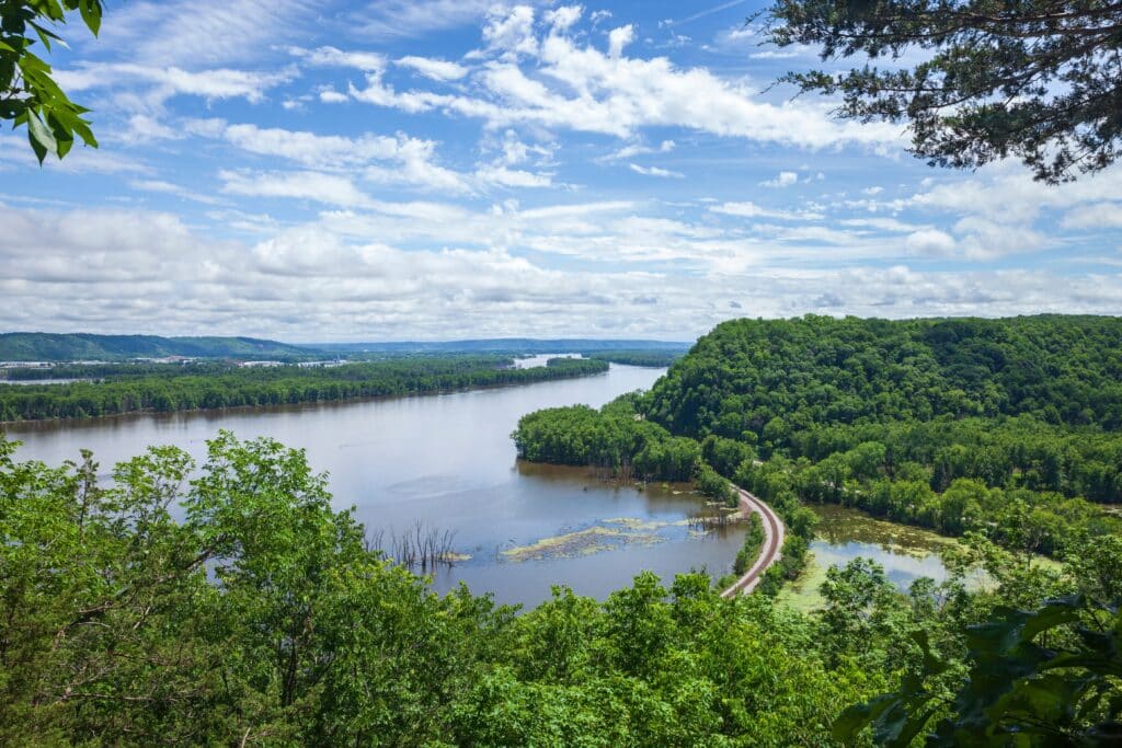
19. Mississippi River Bluffs
The Mississippi River Bluffs rise sharply along Iowa’s eastern edge, introducing elevation and long perspective uncommon elsewhere in the state. These high ridges frame the river corridor below, creating dramatic contrast between water, forest, and sky.
Historically, the bluffs shaped settlement and movement. Towns clustered along the riverbanks, influenced by trade, transport, and connection to wider networks. The bluffs offered protection, orientation, and vantage, reinforcing the importance of geography in early development.
Movement through the bluffs alters perception. Trails climb gradually, shifting experience from enclosed river corridor to expansive regional views. Forested slopes soften sound and light, creating layered sensory experience.
Ecologically, the bluffs support diverse habitats shaped by slope, exposure, and moisture. They function as transition zones between river and upland.
The Mississippi River Bluffs mark Iowa’s enduring connection to broader systems—natural, cultural, and economic—extending far beyond state boundaries.
18. Des Moines
Des Moines functions as Iowa’s civic and economic center, shaped by rivers and regional responsibility rather than spectacle. Its scale remains approachable, reinforcing its role as a gathering point and service hub for the wider state.
The Des Moines and Raccoon Rivers anchor the city physically and symbolically. Trails, parks, and bridges integrate water into daily life, grounding urban activity in natural flow. Public spaces emphasize participation and accessibility.
Neighborhoods reflect balance between work, residence, and recreation. Growth is present but measured, preserving continuity and cohesion. Cultural institutions reinforce education, governance, and shared civic life.
Rather than competing with larger metropolitan centers, Des Moines embraces function and stewardship. It operates as connector rather than destination.
Des Moines represents Iowa’s capacity for leadership without detachment—urban life firmly rooted in regional identity and responsibility.
17. Loess Hills
The Loess Hills rise along Iowa’s western edge, formed by wind-deposited soil rather than stone. Their narrow ridges and steep slopes create a landscape found in few places on Earth, defined by fragility and time.
Tallgrass prairie clings to these hills, emphasizing sensitivity to disturbance. Views extend across valleys toward the Missouri River plain, reinforcing openness despite limited height.
Movement through the hills feels deliberate. Roads and trails follow ridgelines, exposing travelers to wind, light, and expansive sky. The terrain encourages awareness and restraint.
Ecologically rare, the hills support species adapted to dry, shifting soils. Preservation requires careful stewardship.
The Loess Hills represent Iowa’s quiet geological uniqueness—subtle, rare, and shaped by patience rather than force.
16. Amana Colonies
The Amana Colonies reflect a communal settlement tradition shaped by shared belief, labor, and intentional structure. Villages developed with clear purpose, emphasizing cooperation and mutual responsibility over individual display.
Architecture remains modest and functional. Homes, workshops, and agricultural land integrate seamlessly, reinforcing daily connection between work and community. Craft traditions continue alongside modern adaptation.
Cultural continuity here is lived rather than performed. Practices persist because they serve community needs, not because they attract attention.
Preservation balances respect for tradition with relevance. Change occurs slowly and collectively.
The Amana Colonies embody Iowa’s emphasis on continuity—where shared values shape place across generations.
15. Iowa Great Lakes
The Iowa Great Lakes region clusters several natural lakes in the state’s northwest corner, creating a landscape defined by water and horizon. Unlike rivers that move through, these lakes anchor place, encouraging settlement, return, and long-term attachment.
Open water introduces reflection and movement into an otherwise agricultural region. Shorelines slope gently, promoting accessibility and shared use. Light, wind, and weather constantly reshape experience.
Communities orient outward toward the lakes, reinforcing collective gathering. Summer brings activity and connection, while winter quiets the region, restoring focus to form and space.
The lakes shape regional identity beyond recreation. They influence economy, memory, and rhythm.
The Iowa Great Lakes represent balance—where water interrupts uniformity and sustains community continuity.
14. Boone and Scenic Valley
The Boone and Scenic Valley reveals Iowa’s capacity for depth and enclosure through a river corridor shaped by time, water, and movement. The Des Moines River cuts through forested bluffs, creating a narrow passage that contrasts sharply with the surrounding agricultural plains.
This valley developed as a route rather than a destination. Rail lines and bridges trace the river’s path, reinforcing the idea of passage and transition. Movement here follows the land’s logic, bending with curves rather than cutting across them. Elevation shifts are modest but persistent, producing a layered experience.
Forested slopes introduce shadow, sound dampening, and seasonal variation. In summer, dense canopy encloses the corridor; in winter, exposed structure reveals the valley’s form. Wildlife presence feels immediate due to limited human intrusion.
The valley’s scale encourages attentiveness. Views open and close quickly, reinforcing proximity rather than distance. This compression intensifies awareness of terrain and flow.
The Boone and Scenic Valley highlights Iowa’s understated vertical dimension—subtle, immersive, and shaped by water’s persistence.
13. Cedar Rapids
Cedar Rapids is shaped by industry, river, and long-term resilience. Situated along a major waterway, the city developed through manufacturing, milling, and transport, embedding work deeply into its civic identity.
Urban form reflects practicality rather than display. Neighborhoods, factories, warehouses, and civic institutions coexist closely, reinforcing daily connection between labor and community life. The Cedar River remains central, both as resource and reminder of vulnerability.
Periods of disruption strengthened civic cohesion. Recovery emphasized rebuilding function rather than image, underscoring endurance and adaptability. Infrastructure and public space reflect this ethic.
Cultural life here grows from participation—local institutions, sports, and neighborhood networks reinforce belonging. The city maintains outward economic reach while preserving internal stability.
Cedar Rapids represents Iowa’s working urban core: durable, grounded, and shaped by responsibility rather than ambition.
12. Effigy Mounds National Monument
Effigy Mounds National Monument preserves ancient earthworks set among wooded bluffs overlooking the Mississippi River. These mounds, shaped like animals and geometric forms, represent deliberate human presence embedded in landscape rather than imposed upon it.
The surrounding terrain enhances their significance. Forested slopes, limestone outcrops, and river views create layered spatial experience. Trails encourage slow movement and quiet observation, revealing mounds gradually.
The site prioritizes respect and restraint. Interpretation emphasizes continuity, memory, and cultural endurance rather than spectacle. The river below reinforces temporal depth, connecting centuries of human movement.
Ecologically, the monument preserves native woodland and bluff habitat, reinforcing balance between protection and access.
Effigy Mounds connect land, culture, and time—illustrating Iowa’s deep human history through subtle presence.
11. Pella
Pella reflects immigrant settlement shaped by faith, agriculture, and intentional preservation. Founded by Dutch settlers, the town developed around shared values emphasizing community cohesion and stewardship.
The town’s layout reinforces these principles. Civic spaces anchor daily life, while surrounding farmland maintains connection between town and countryside. Architecture reflects continuity without rigidity.
Cultural traditions remain integrated into everyday routines. Festivals, institutions, and local businesses reinforce identity while allowing gradual adaptation.
Economic life balances heritage with contemporary function. Tourism exists but does not overwhelm local rhythms.
Pella represents Iowa’s cultural layering—heritage informing present life through balance, restraint, and continuity.
10. Maquoketa Caves State Park
Maquoketa Caves State Park introduces a rare sense of enclosure and complexity into Iowa’s largely open landscape. Limestone formations, narrow passages, sinkholes, and shaded ravines create a terrain shaped by erosion rather than elevation, offering depth without height.
The caves themselves are scattered rather than centralized, requiring movement through forest and bluff to experience them. This dispersal reinforces exploration and attentiveness. Temperature shifts, damp stone, and filtered light heighten sensory awareness.
Above ground, dense woodland and rock outcroppings create containment uncommon in Iowa. Trails wind through uneven terrain, alternating between openness and compression. Seasonal change dramatically alters mood, from lush enclosure in summer to exposed structure in winter.
The park’s scale remains intimate. Human presence feels temporary and respectful, reinforcing balance between access and preservation.
Maquoketa Caves reveal Iowa’s hidden interior—a landscape defined by patience, erosion, and quiet surprise.
9. Upper Iowa River
The Upper Iowa River flows through the Driftless region, carving a winding corridor between wooded bluffs and rolling farmland. Its course feels organic and unforced, shaped by continuity rather than engineering.
The river introduces motion and sound into a quiet landscape. Canoe routes follow gentle bends, encouraging slow travel and close observation. Cliffs and trees rise close to the water, reinforcing intimacy and enclosure.
Human presence remains light. Small communities along the river maintain agricultural ties while respecting natural flow. Seasonal rhythms govern use, with spring water and autumn color shaping experience.
Ecologically rich, the river supports diverse species adapted to bluff and valley habitat.
The Upper Iowa River represents balance—where water, terrain, and human activity coexist through restraint.
8. Decorah
Decorah is a town shaped by landscape, education, and cultural continuity. Set among bluffs and river valleys, it feels grounded and outward-looking, connected equally to land and ideas.
The town’s walkable layout encourages interaction. Cultural institutions, local businesses, and educational presence reinforce cohesion rather than division. Norwegian heritage contributes depth without becoming static or ornamental.
Outdoor access remains integrated into daily life. Trails, rivers, and parks sit close to residential and civic spaces, reinforcing balance between work, thought, and environment.
Seasonal change is visible and celebrated. Community life adjusts naturally to climate and light.
Decorah reflects Iowa’s capacity for intellectual engagement rooted firmly in place.
7. Clear Lake
Clear Lake is defined by openness and horizon. The broad expanse of water interrupts agricultural continuity, creating a focal point for gathering, reflection, and movement.
The lake’s scale supports shared use rather than exclusivity. Shorelines remain accessible, reinforcing community connection. Light and weather play a constant role, reshaping experience throughout the day and year.
The surrounding town maintains balance. Development supports lake life without overwhelming it. Cultural memory and local identity remain closely tied to water.
Clear Lake functions as anchor rather than attraction—a place where rhythm and continuity matter.
It represents Iowa’s relationship with water as place rather than passage.
6. Council Bluffs
Council Bluffs sits along the Missouri River, marking Iowa’s western edge and historic gateway. Its identity is shaped by movement, exchange, and transition rather than isolation.
Bluffs rise sharply from the river plain, offering elevation and perspective rare in western Iowa. Transportation corridors—historic and modern—reinforce outward orientation and connection beyond the state.
The city’s layout reflects working heritage. Neighborhoods, industry, and infrastructure coexist closely, reinforcing functional cohesion.
Council Bluffs balances edge and center, serving as threshold between regions.
It represents Iowa’s role as connector—anchored by river, ridge, and responsibility.
5. Neal Smith National Wildlife Refuge
Neal Smith National Wildlife Refuge offers a deliberate reconstruction of Iowa’s original tallgrass prairie. Once dominant across the state, this ecosystem now survives here through intentional restoration rather than accident or remoteness.
Rolling ground supports native grasses and wildflowers that change texture, color, and height with season and light. Movement through the refuge emphasizes openness and exposure. There are few trees, few visual barriers, and little shade, reinforcing awareness of wind, sky, and distance.
Bison and elk reintroduce scale and motion, reshaping perception of prairie as dynamic rather than static. Their presence reconnects land to its historic rhythms.
The refuge functions as both landscape and lesson. It demonstrates how identity can be recovered without erasing agricultural history.
Neal Smith reveals Iowa’s foundational ecology—resilient, expansive, and defined by continuity rather than spectacle.
4. Ledges State Park
Ledges State Park introduces dramatic enclosure along the Des Moines River, where sandstone cliffs rise abruptly from narrow valleys. The shift from surrounding farmland to forested ravine feels immediate and immersive.
Stone formations define movement. Paths wind between walls of rock, crossing shallow water and shaded ground. Light filters unevenly, altering perception throughout the day.
The park’s compact scale intensifies experience. Elevation changes feel amplified, and sound carries differently within enclosed space.
Seasonal variation reshapes the landscape. Flooding, leaf cover, and snow transform both access and mood.
Ledges State Park highlights Iowa’s capacity for sudden, contained drama shaped by erosion and water.
3. Sioux City
Sioux City stands at the intersection of river, plains, and transportation corridors. Its position along the Missouri River shaped development tied to movement, exchange, and industry.
The city’s form reflects working heritage. Rail lines, stockyards, and factories influenced growth, embedding labor into civic identity. Bluffs rise nearby, providing elevation and visual contrast.
Neighborhoods remain closely connected to industrial and commercial zones, reinforcing practicality over separation.
Sioux City functions as a western anchor for Iowa—outward-facing and transitional.
It represents Iowa’s engagement with broader regional systems beyond its borders.
2. Prairie du Chien Crossing (Eastern Iowa Wetlands)
Eastern Iowa’s wetlands along the Mississippi River form a shifting landscape of backwaters, sloughs, and floodplain forest. Water defines space here, expanding and retreating with seasonal flow.
Movement through the wetlands feels adaptive. Channels change, vegetation shifts, and wildlife presence remains constant. The environment rewards patience and attentiveness.
These areas serve as ecological buffers, supporting biodiversity while absorbing flood cycles. Human access remains light and responsive.
The wetlands emphasize Iowa’s relationship with variability and renewal rather than control.
They represent the state’s most fluid and transitional landscapes.
1. Winterset
Winterset is a town shaped by surrounding farmland, gentle hills, and enduring civic structure. Known for its stone bridges, the town reflects craftsmanship tied directly to local materials and labor.
The layout emphasizes cohesion. Civic buildings, residential streets, and commercial areas remain closely connected. Paths and bridges link town to countryside, reinforcing continuity between daily life and land.
Seasonal change is central to experience. Fields, trees, and waterways shape rhythm and memory across the year.
Winterset maintains stability without stagnation. Change occurs gradually, guided by shared responsibility.
It represents Iowa’s enduring small-town identity—grounded, connected, and quietly resilient.