
Cameroon is often called “Africa in miniature,” but the phrase only hints at its depth. The country’s diversity is not compressed into spectacle; it unfolds gradually across terrain. Coastlines give way to rainforests, forests rise into highlands, and savannah stretches toward the Sahel. Each shift in geography alters climate, language, architecture, and rhythm of life. To travel through Cameroon is to feel the land actively recalibrating how people live, speak, and imagine themselves.
Here, geography is formative rather than decorative. Volcanic soil determines farming practices. Elevation cools speech and pace. Rainfall dictates settlement patterns and seasonal movement. The land does not merely host culture; it collaborates with it. Communities adapt carefully, learning how to listen to terrain that can be generous one season and demanding the next.
Cameroon’s destinations resist quick interpretation. Many places reveal themselves only through time—through market cycles, agricultural rhythms, or the slow earning of local trust. Roads do not always move directly, and neither do stories. Rivers bend, mountains interrupt, forests obscure. Yet these features create coherence rather than confusion. They teach attentiveness.
This writing approaches Cameroon through place as experience, not inventory. Each destination chapter focuses on how geography shapes mood, memory, and possibility. Inspiration here is grounded—in volcanic rock, humid air, highland mist, and open grassland. These are not landmarks to be consumed, but environments to be entered.
Cameroon invites a slower form of understanding. It rewards those who notice transitions, who accept that meaning often emerges between regions rather than within borders. The land asks for patience and offers perspective in return. To move through Cameroon is to recognize that becoming—personal or collective—is always tied to where one stands.
20. Douala
Douala sits low and humid along the Wouri River, Cameroon’s economic heart shaped by water, heat, and constant exchange. The city’s coastal geography defines its temperament. Rain arrives heavily and without apology, flooding streets and cooling air thick with salt and movement. The river carries cargo, memory, and possibility, reinforcing Douala’s identity as a place of arrival and departure.
As a port city, Douala absorbs the world quickly. Goods, languages, and ambitions pass through daily, leaving traces in markets and neighborhoods that feel perpetually in motion. The city is dense and demanding, yet deeply alive. Streets pulse with commerce, music, and negotiation, all shaped by proximity to water that never rests.
Mangroves fringe the city’s edges, reminding residents that nature still presses close. These wetlands soften the shoreline and protect inland communities, even as development pushes outward. The geography forces compromise—between expansion and restraint, urgency and patience.
Douala inspires through endurance. It shows how a city can remain productive under pressure, adapting continuously to climate and congestion. Life here requires alertness: knowing when to move, when to wait, when to yield to rain or tide.
There are quieter moments, often at dusk, when the river reflects fading light and traffic slows just enough to breathe. In those moments, Douala reveals its balance—not between ease and struggle, but between persistence and creativity. The city teaches that survival in demanding terrain can generate its own rhythm, one built on responsiveness rather than control. Douala does not offer comfort first; it offers momentum, and for those willing to keep pace, meaning follows.
19. Yaoundé
Yaoundé rises across a series of green hills, Cameroon’s political capital shaped by elevation and restraint. Unlike the urgency of the coast, the city feels deliberate. Roads curve gently rather than cut sharply, and the terrain encourages pause. Hills interrupt sightlines, creating moments of enclosure that foster reflection.
The climate here is softer. Rain falls regularly, but the air remains cooler than in the lowlands, giving Yaoundé a measured rhythm. Government buildings occupy prominent ground, but everyday life unfolds across neighborhoods where markets, schools, and homes coexist without spectacle. The city’s geography resists haste, encouraging movement that feels considered rather than reactive.
Yaoundé’s position inland gives it a bridging role. Cultures from forest regions and grasslands intersect here, shaping language, cuisine, and social interaction. The city absorbs difference quietly, allowing overlap rather than competition. This moderation reflects the land itself—neither extreme nor passive, but steady.
Inspiration in Yaoundé comes from balance. It demonstrates how authority can exist without dominance, how planning can coexist with organic growth. From hilltops, the city appears spread out and unfinished, reminding visitors that capitals, like nations, remain in progress.
Yaoundé teaches that perspective often comes from elevation, not distance. The hills do not remove you from complexity; they help you see it more clearly. The city’s calm does not deny challenge, but it reframes it. Here, geography offers a lesson in proportion—how to hold responsibility without becoming consumed by it.
18. Bafoussam and the Western Highlands
Bafoussam sits within Cameroon’s western highlands, where elevation reshapes climate and community alike. The land rises into rolling hills and fertile valleys, producing cooler air and soil that supports intensive agriculture. This geography fosters density—not of buildings alone, but of social connection.
The highlands are among the country’s most productive regions. Farms cling to slopes, carefully managed to prevent erosion while maximizing yield. Coffee, maize, and vegetables sustain both local life and national markets. The land demands effort, and communities respond with organization and cooperation.
Bafoussam itself feels energetic but grounded. Markets are busy, yet structured; movement is purposeful rather than chaotic. The city’s location makes it a crossroads, drawing traders and travelers from surrounding towns. Cultural traditions remain strong, reinforced by proximity to ancestral land and visible continuity.
What inspires here is intentional living. The highlands show how adaptation can be collective, how geography encourages shared responsibility. Space is used carefully, time respected. Even celebrations reflect this grounding, tied closely to agricultural cycles and communal identity.
From surrounding hills, the landscape reveals itself in layers—fields, settlements, forest edges—each dependent on the other. The highlands teach that productivity and sustainability need not oppose one another. Bafoussam and its region offer a vision of progress rooted in land awareness, where elevation brings not escape, but accountability. The terrain shapes character, and the people respond with resilience sharpened by altitude.
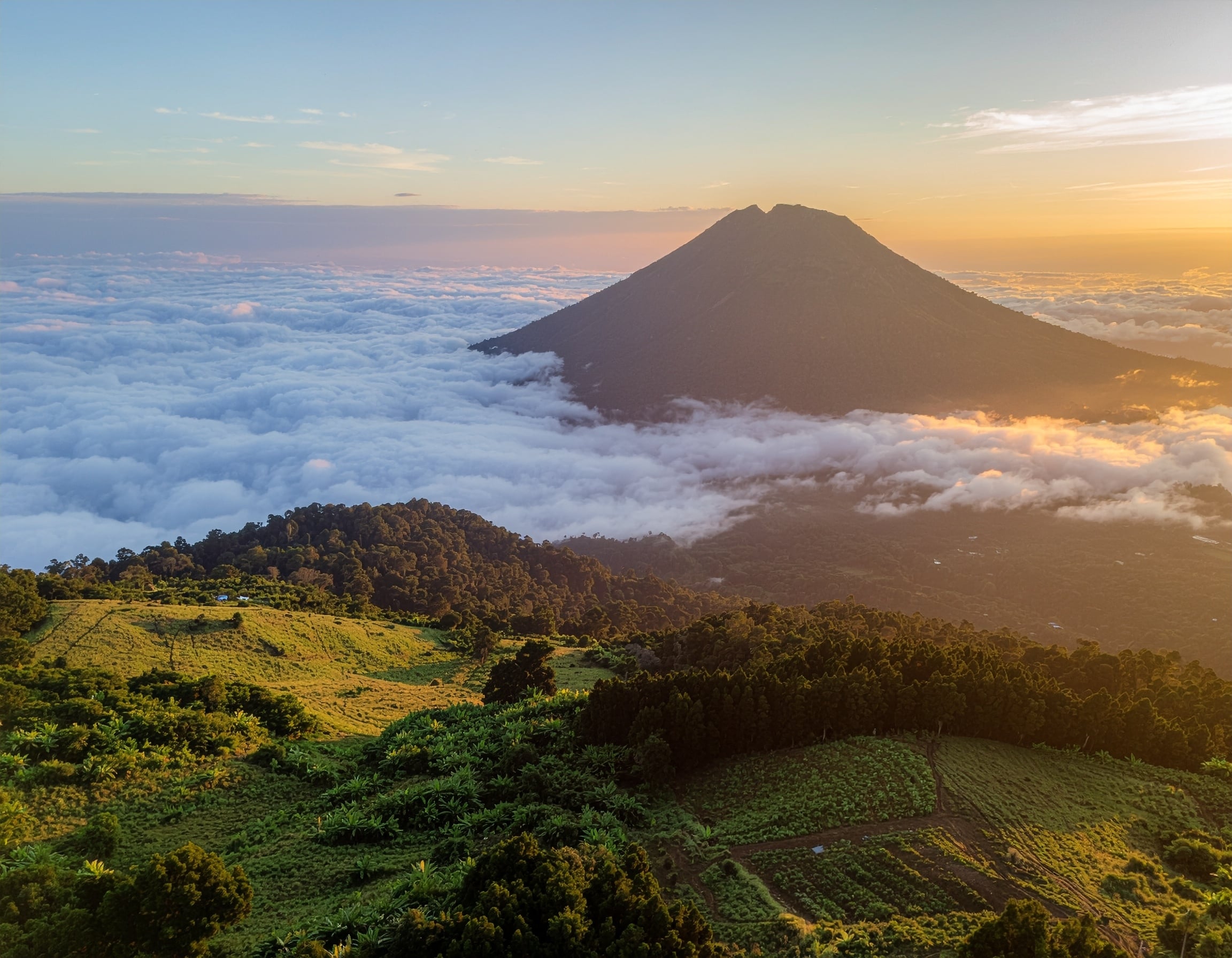
17. Mount Cameroon
Mount Cameroon rises abruptly from the Atlantic coast, a volcanic presence that dominates both landscape and imagination. At over 4,000 meters, it is one of West Africa’s highest peaks, its slopes cutting through multiple ecological zones—from tropical forest to alpine grassland. Geography here is dramatic and uncompromising.
The mountain is alive. Volcanic soil remains fertile but unstable, reminding nearby communities that creation and destruction share the same source. Villages at the base farm rich land while respecting boundaries set by past eruptions. Weather changes quickly, and ascent demands humility.
Climbing Mount Cameroon is less about conquest than encounter. The journey reveals shifting temperatures, vegetation, and perspective. Each stage strips away distraction, replacing it with breath, effort, and awareness of scale. The land asserts itself fully, offering no shortcuts.
Inspiration comes from proximity to power. The mountain teaches respect—for natural force, for preparation, for limits. It stands as a reminder that not all challenges are meant to be subdued; some are meant to be understood.
From its heights, the coast appears distant, the ocean vast, and human activity small but persistent. Mount Cameroon reframes ambition, grounding it in physical reality. It offers clarity earned through exertion, a lesson that some understanding only comes when the land leads and the traveler follows.
16. Garoua and the Northern Plains
Garoua lies along the Benoué River in northern Cameroon, where savannah stretches wide and the climate demands foresight. The land here is open, hot, and seasonal. Life organizes itself around water availability, shade, and timing. Geography sets firm terms.
The river is the region’s anchor. It supports farming, fishing, and transport, turning otherwise demanding terrain into productive ground. During the dry season, its presence becomes even more significant, shaping settlement and movement. Communities understand its rhythms intimately.
Garoua moves at a deliberate pace. Early mornings and evenings are active, while midday heat enforces rest. Architecture reflects necessity—thick walls, courtyards, shaded spaces. Markets gather goods from surrounding pastoral and farming communities, reinforcing Garoua’s role as connector.
What inspires in Garoua is discipline shaped by environment. The land teaches restraint and planning, values reflected in social structures and daily routines. There is clarity here, born of necessity rather than choice.
The northern plains remind visitors that abundance is contextual. Where resources are limited, cooperation becomes essential. Garoua shows how geography can produce not scarcity of culture, but concentration of purpose. The land does not offer excess; it offers structure. And within that structure, life persists with quiet strength and adaptability.
15. Limbe
Limbe rests where Mount Cameroon’s slopes meet the Atlantic, a town shaped by black volcanic sand, salt air, and constant motion between land and sea. The coastline curves gently, framed by palm trees and rock formations that speak to the area’s volcanic origin. Geography here is intimate and dynamic, demanding attentiveness.
The ocean sets Limbe’s rhythm. Fishing boats leave early, returning as the sun climbs, while tides reshape the shoreline daily. Rain is frequent, cooling afternoons and feeding vegetation that climbs aggressively toward the mountain. The land feels alive, responsive, and sometimes unpredictable.
Limbe’s identity is layered. Once a colonial port, it now balances industry, education, and community life. The botanical garden, one of the oldest in Africa, reflects this coexistence—ordered pathways cutting through lush growth, human design negotiating with tropical abundance.
What inspires in Limbe is proximity. The mountain looms close, the sea ever-present, compressing scale and heightening awareness. You are constantly reminded of natural forces larger than daily routine. Even leisure carries that awareness; walks along the beach are framed by surf and distant rumble from Mount Cameroon’s slopes.
Limbe teaches that beauty can be active rather than serene. The land does not offer passive comfort; it invites engagement. Geography here sharpens the senses, encouraging presence and respect. In Limbe, the meeting of volcano and ocean becomes a lesson in coexistence—how opposing forces can share space without canceling one another, shaping a place that is resilient, alert, and unmistakably alive.
14. Kribi
Kribi sits along Cameroon’s southern coast, where white sand beaches meet dense rainforest and rivers empty directly into the Atlantic. The geography is generous, offering openness without exposure. Unlike more industrial ports, Kribi feels relaxed, shaped by distance and water rather than urgency.
The Lobé River, flowing straight into the ocean, defines the town’s imagination. Waterfalls spill directly into saltwater, collapsing boundaries between fresh and marine environments. This rare convergence shapes livelihoods and stories, reinforcing the sense that geography here resists rigid categories.
Fishing anchors daily life. Nets dry in the sun, boats gather in loose clusters, and markets respond to the ocean’s generosity. Inland, forest edges press close, reminding visitors that Kribi is not just a beach town, but a coastal threshold to deeper terrain.
Kribi inspires through ease without emptiness. The town does not rush, but it does not retreat either. Its pace reflects confidence shaped by dependable geography—fertile land, accessible water, predictable seasons. Even development arrives gradually, absorbed rather than imposed.
What Kribi teaches is that calm can be productive. The land supports livelihood without spectacle, offering beauty that does not demand attention. Here, geography creates permission to slow down and observe continuity—between forest and sea, labor and rest. Kribi’s appeal lies not in escape, but in alignment: a place where land and life move together, quietly reinforcing one another.
13. Bamenda
Bamenda lies within Cameroon’s northwestern highlands, a city shaped by elevation, enclosure, and mist. The land rises sharply, forming valleys and ridges that define settlement and movement. Geography here is not background; it directs how people live and connect.
Cooler temperatures soften the pace, encouraging outdoor gathering and extended conversation. The surrounding hills are deeply cultivated, with terraces supporting crops that cling carefully to slopes. Farming is visible from nearly every vantage point, reinforcing a relationship between effort and reward.
Bamenda’s markets are dense and expressive, reflecting both highland productivity and cultural diversity. The city acts as a hub, drawing surrounding villages into daily exchange. Roads wind through hills, reinforcing a sense of arrival earned rather than assumed.
What inspires in Bamenda is community shaped by terrain. The land limits expansion, encouraging cohesion and mutual reliance. Space is precious, and relationships fill it. Cultural expression—music, storytelling, ceremony—thrives in this environment, grounded in place and memory.
Bamenda teaches attentiveness. The hills slow movement, and in doing so, deepen connection. Geography insists that nothing here is rushed without consequence. The city’s strength lies in its rootedness, its ability to remain legible to itself. In Bamenda, the land teaches that elevation brings not separation, but clarity—an understanding that belonging is cultivated, like the hillsides themselves, through care and persistence.
12. Waza National Park
Waza National Park stretches across Cameroon’s far north, a vast expanse of savannah where openness dominates perception. The land is flat and wide, allowing the sky to assert itself fully. Geography here emphasizes scale and exposure, reshaping how time and distance are experienced.
Seasonal cycles govern everything. During the wet season, floodplains revive grasses and draw wildlife. In the dry months, water recedes, concentrating life around remaining sources. The park’s ecosystems depend on this rhythm, reinforcing the importance of patience and observation.
Waza’s wildlife—elephants, antelope, lions, and birds—move according to land rather than boundary. Their presence underscores the value of space left uninterrupted. Human intervention is minimal, allowing natural processes to remain visible and instructive.
Inspiration in Waza comes from restraint. The park demonstrates the power of protection, of allowing land to function on its own terms. Silence carries weight here, broken only by wind or distant movement.
Waza teaches humility. The vastness diminishes individual urgency, replacing it with awareness of interdependence. Geography here does not accommodate haste or excess. It rewards those who wait, who watch patterns emerge slowly. In a region where resources can be scarce, Waza stands as evidence that preservation itself is a form of abundance—one measured not in extraction, but in continuity.
11. Foumban
Foumban sits in western Cameroon, where highland geography supports both agriculture and cultural concentration. Surrounded by rolling hills, the city feels contained yet expressive. The land encourages settlement rather than sprawl, reinforcing a strong sense of place.
As the historic seat of the Bamum Kingdom, Foumban’s identity is inseparable from tradition. The royal palace and museum stand prominently, but they do not overwhelm the city. Instead, they integrate with daily life, reflecting continuity rather than separation between past and present.
The surrounding land is fertile, supporting farming that sustains both city and countryside. Rainfall is reliable, and agricultural cycles structure time. Markets pulse with locally produced goods, reinforcing economic independence tied to geography.
Foumban inspires through coherence. The city shows how culture can remain active when grounded in land that supports memory. Art, craftsmanship, and language thrive here not as performance, but as lived practice.
Geography reinforces this stability. The hills create boundaries that protect identity without isolating it. Foumban teaches that preservation is not stagnation; it is deliberate continuity. The land holds tradition in place, allowing it to evolve without erasure. To experience Foumban is to see how geography can nurture cultural clarity—how place, when respected, becomes an ally of history rather than a constraint.
10. Buea
Buea rests on the lower slopes of Mount Cameroon, a town shaped by altitude and anticipation. The land rises steadily, cooling the air and softening movement. Clouds drift in without warning, briefly enclosing the town in mist before lifting again. Geography here feels intimate and watchful.
Once the colonial capital, Buea retains a sense of order rooted in its layout. Streets follow the mountain’s incline, and buildings adapt to slope and rainfall rather than resist them. The soil is dark and fertile, supporting gardens and small farms that blur the line between urban and rural life.
The mountain dominates daily awareness. Its presence influences weather, agriculture, and imagination. Residents read signs in cloud cover and wind, understanding that the land speaks continuously. Even quiet days carry the possibility of change, reinforcing humility and preparedness.
Buea inspires through attentiveness. The town teaches how to live near power without challenging it. Rather than compete with the mountain, life here aligns itself carefully, respecting boundaries shaped by past eruptions and present conditions.
What Buea offers is clarity born of proximity. Being close to something vast and active refines judgment. The land does not allow distraction for long. In Buea, geography cultivates awareness, reminding visitors that stability is often achieved not by control, but by careful listening and adaptation.
9. Ebolowa
Ebolowa lies deep within Cameroon’s southern rainforest, a town shaped by dense vegetation and red laterite soil. The forest presses close, enclosing space and sound, creating an atmosphere that feels inward and deliberate. Geography here favors intimacy over distance.
Rainfall is frequent and generous, sustaining cocoa, plantain, and cassava farms that support surrounding communities. Roads wind through forest corridors, reinforcing a sense of arrival earned through patience. Movement is slower, guided by terrain and weather rather than urgency.
Ebolowa’s daily life reflects this environment. Markets feel grounded, filled with produce drawn directly from nearby land. Social interactions linger, shaped by familiarity and shared dependence on the forest’s rhythms. The land does not invite haste; it requires cooperation.
What inspires in Ebolowa is quiet continuity. The town demonstrates how life can remain coherent when closely tied to natural systems. The forest provides, but it also demands care. Knowledge here is practical—when to plant, when to harvest, when to wait.
Ebolowa teaches respect for limits. Geography reinforces the idea that progress need not mean expansion. Instead, it can mean refinement—learning how to live well within defined space. The forest does not yield easily, but it sustains those who understand its timing. In Ebolowa, geography becomes teacher rather than obstacle.
8. Maroua
Maroua stands near Cameroon’s northern edge, where savannah thins toward the Sahel and the land asserts constraint. Heat defines the day, and survival depends on foresight. Geography here is uncompromising, shaping discipline and clarity.
The surrounding Mandara Mountains rise nearby, offering contrast to the flat plains. These formations provide shade, water catchment, and historical refuge, reinforcing the region’s layered adaptation to environment. The land alternates between openness and shelter.
Maroua’s markets are among the most vibrant in the north, drawing traders from across borders. Goods reflect geography—grains, livestock, leather—products suited to dry conditions. Movement follows climate: mornings are active, afternoons reserved, evenings communal.
Maroua inspires through resilience sharpened by necessity. The land allows little waste, encouraging efficiency and cooperation. Architecture responds directly to climate, prioritizing shade and airflow. Life aligns itself carefully with environment rather than resisting it.
The city teaches that constraint can produce strength. Geography here narrows options but clarifies priorities. In Maroua, survival is not dramatic; it is disciplined. The land offers no excess, but it rewards understanding. That balance—between limitation and endurance—defines the city’s quiet authority.
7. Dschang
Dschang sits high in Cameroon’s western highlands, where cooler temperatures and fertile soil create a sense of measured abundance. The land rolls gently, supporting agriculture that feels both intentional and sustained. Geography here encourages planning rather than improvisation.
The town’s elevation softens daily life. Air is crisp, mornings clear, and evenings reflective. Roads feel spacious, and movement carries less urgency. Farms surround the town, producing food that anchors local economy and diet.
Dschang’s academic presence adds to its reflective tone, reinforcing a culture of observation and inquiry. Knowledge here feels grounded, shaped by direct relationship with land and community. The environment supports thinking that unfolds slowly.
Dschang inspires through balance. It demonstrates how elevation can temper pace without isolating place. The land supports productivity while allowing rest. Fields and classrooms coexist naturally, each reinforcing the other.
What Dschang teaches is moderation. Geography offers enough—enough food, enough space, enough quiet—to support stability. The town stands as a reminder that sustainability is not about abundance alone, but about alignment. When land and lifestyle correspond, continuity follows.
6. Campo Ma’an
Campo Ma’an lies at Cameroon’s southern edge, where rainforest meets ocean and national borders blur into ecological continuity. The land is dense and alive, shaped by rivers, forest canopy, and coastal wetlands. Geography here resists fragmentation.
As a protected area, Campo Ma’an prioritizes preservation over expansion. Wildlife corridors stretch across forest and shoreline, reinforcing the importance of uninterrupted space. Human presence is careful, measured, and often collaborative with conservation efforts.
The forest dictates movement and sound. Paths are narrow, light filtered, and distance deceptive. Rivers guide travel as much as roads, reinforcing reliance on natural systems. The land demands awareness.
Campo Ma’an inspires through restraint. It shows how intentional limitation can protect complexity. Geography here teaches that not all value is visible immediately; some unfolds slowly, through continuity and care.
The region offers a vision of coexistence. Communities live alongside preservation, adapting livelihoods to ecological boundaries. Campo Ma’an reminds visitors that geography is not only where life happens—it is what life depends on. Respecting it becomes not sacrifice, but strategy, ensuring that richness remains intact for what comes next.
5. Garoua-Boulaï
Garoua-Boulaï sits in Cameroon’s eastern borderlands, where the dense forests of the Congo Basin begin to thin into savannah corridors. Geography here dictates rhythm: land opens slowly, allowing travel by road or river, while the climate—hot and humid with pronounced wet and dry seasons—demands careful timing in both work and movement.
The town serves as a bridge, both literal and symbolic, linking Cameroon with neighboring Central African nations. Trade flows along its roads and rivers, shaping livelihoods dependent on timing, knowledge of terrain, and patience. Markets pulse not just with goods but with conversation, negotiation, and the slow accumulation of trust.
Rainfall leaves its mark, turning unpaved tracks into streams or softening the soil to feed crops. Forest edges remain visible, reminders of the fertile ecosystems that have nurtured communities for generations. Geography here emphasizes adaptation: life must respond to seasons, resource availability, and distance.
Garoua-Boulaï inspires through connectivity. It demonstrates that significance can emerge from location itself—where borders, ecology, and human ambition intersect. The town teaches resilience, showing how humans can thrive by aligning closely with land rather than attempting to impose upon it.
Here, geography becomes both guide and mentor. Travelers quickly learn that pace is relative, that patience is not passive, and that understanding the land is as important as moving through it. Garoua-Boulaï leaves a lasting impression of equilibrium: a place where terrain shapes ambition, and adaptation becomes its own form of mastery.
4. Foumbot
Foumbot lies in Cameroon’s western highlands, surrounded by gently undulating hills and fertile valleys. The soil is rich, supporting crops that feed both local communities and distant markets. Geography here encourages settlement and cultivation in measured harmony, demanding patience and careful observation.
The town itself feels contained yet expansive, anchored by nearby hills and natural waterways. Daily life is closely tied to agriculture, as planting and harvest cycles dictate routines. Markets gather crops and crafts, reflecting a deep interconnection between land and livelihood. Roads wind through slopes, emphasizing both arrival and perspective.
Foumbot inspires through its groundedness. The town shows how meaning grows from continuity, how people, land, and labor reinforce one another. Cultural traditions and local festivals echo the agricultural calendar, reinforcing temporal awareness rooted in place.
Rainfall is generous yet seasonal, cooling the earth and supporting crops while teaching attentiveness. Residents learn to read clouds, wind, and soil, adapting schedules and expectations accordingly. Geography here requires humility and awareness, qualities reflected in both social cohesion and day-to-day work.
Foumbot demonstrates that abundance can emerge from rhythm rather than speed. It is a place where patience is active, where the land itself guides decision-making. In Foumbot, geography offers lessons not as obstacles, but as enduring partners in shaping life, culture, and productivity.
3. Sangmélima
Sangmélima rests deep within Cameroon’s southern rainforest belt, where hills rise from dense forest and rivers thread the landscape. The land is humid, fertile, and alive, requiring careful negotiation for both travel and settlement. Geography is intimate here: movement is constrained by terrain yet rewarded with beauty and abundance.
The town thrives on agriculture and forestry, drawing sustenance from fertile soil and frequent rainfall. Cocoa, plantains, and bananas grow alongside cultivated forests, creating a mosaic of life that sustains local markets and daily routines. Villages blend seamlessly with the landscape, reminding travelers that human presence here exists in concert with ecology.
Sangmélima inspires through attentiveness. Residents and visitors alike must observe seasonal changes, soil conditions, and river levels. The rainforest teaches responsiveness, shaping rhythm, decision-making, and community cooperation. Life here reflects patience and engagement rather than haste.
Paths wind through greenery, occasionally opening to vistas of hills or river valleys. Even small moments—the smell of wet earth after rain, the sound of water trickling through forest—reveal connection between geography and perception. The land does not yield easily, but it sustains richly when understood.
Sangmélima demonstrates that reflection is built into geography. It encourages observers to notice subtle patterns and cycles, and rewards alignment with environment. Here, the rainforest is not backdrop—it is active participant, shaping culture, labor, and imagination. The town leaves an impression of quiet resilience, a reminder that attentiveness to place cultivates both survival and meaning.
2. Tiko
Tiko lies along Cameroon’s southwestern coast, framed by beaches, river estuaries, and volcanic soil extending from nearby Mount Cameroon. The town balances the ocean’s openness with forested inland slopes, creating a geography that is both generous and demanding.
Fishing anchors daily life, while agriculture extends inland. The land’s fertility supports plantations of bananas, oil palms, and other tropical crops. Waterways dictate travel and trade, requiring residents to align routines with tides, rainfall, and river behavior. Geography shapes daily rhythm as much as culture does.
Tiko inspires through coordination. It demonstrates that human activity achieves its greatest success when aligned with environmental patterns. Life here is negotiated continuously: rain dictates schedules, soil fertility shapes production, and the ocean frames both risk and opportunity.
Even leisure carries awareness. Beaches are punctuated with small boats, riverbanks teem with life, and the proximity of Mount Cameroon reminds the town of scale and permanence. Geography teaches perspective: both challenge and generosity are inseparable from the land.
Tiko is a lesson in coexistence. The town thrives by respecting limits and possibilities set by place. Residents move with attentiveness, adapting to tides, slopes, and soil, while visitors quickly learn that productivity, beauty, and rhythm emerge from negotiation with terrain, not domination over it.
1. Bafia
Bafia lies in central Cameroon, within gently rolling forested hills that open toward fertile savannah. The land encourages agriculture, settlement, and human interaction, offering space without extreme exposure. Geography here supports cohesion, with rivers and paths guiding both movement and social patterns.
The town’s economy depends on farming—cassava, maize, and vegetables dominate—but daily life is equally shaped by forests, seasonal rainfall, and the slow rhythms of land. Markets gather both goods and conversation, blending human and geographic patterns in ways that feel natural and inevitable.
Bafia inspires through integration. The town demonstrates how communities adapt to land, allowing the environment to inform rather than restrict. Residents read soil, weather, and river behavior carefully, shaping livelihoods in harmony with cycles.
Even small details reflect geography’s role. Roads curve around hills, houses are sited for drainage, and farmland patterns mirror terrain rather than resist it. The land is practical, abundant, and quietly assertive.
Bafia teaches that stability emerges from attentiveness. Progress does not require speed or dominance; it requires respect for patterns inherent in place. The town leaves a lasting impression: that life anchored in geography, rather than in force, produces continuity, resilience, and a sense of rooted purpose.