
Thailand lies at the center of mainland Southeast Asia, bordered by Myanmar, Laos, Cambodia, and Malaysia, with coastlines along the Andaman Sea and the Gulf of Thailand. Geography defines the country through four major regions: mountainous north, central river plains, northeastern plateau, and southern peninsular coastline.
The Chao Phraya River basin dominates central Thailand. Geography reinforces agricultural productivity through fertile floodplains shaped by seasonal monsoon cycles. The river flows southward into the Gulf of Thailand, forming one of Southeast Asia’s most productive lowland systems.
Northern Thailand consists of forested mountains and interlocking valleys. Geography binds settlement to river corridors carved between upland ridges.
The northeastern region, known as the Khorat Plateau, is elevated and gently rolling. Geography emphasizes dry-season variation and watershed dependency.
Southern Thailand narrows into a peninsula bordered by two seas. Geography reinforces maritime orientation and coastal diversity shaped by tides, limestone formations, and tropical rainfall.
Climate follows a tropical monsoon pattern, with wet and dry seasons influencing agriculture, river levels, and coastal conditions. Geography requires adaptation to seasonal rainfall intensity and occasional tropical storms.
Thailand inspires through regional diversity within a compact national boundary. The land teaches endurance through adaptation to mountains, rivers, plateaus, and coastlines. Resilience here emerges from alignment with seasonal cycles and geographic variation.
Endurance in Thailand is hydrological, agricultural, and coastal. Stability depends on watershed protection, sustainable coastal management, and floodplain stewardship.
Thailand reflects a country shaped by river systems and maritime exposure, where resilience develops through coexistence between inland plains and surrounding seas.
19. Bangkok
Bangkok lies in central Thailand along the lower Chao Phraya River near its mouth at the Gulf of Thailand. Geography here is low-lying and deltaic, shaped by centuries of sediment deposition.
The terrain is flat and close to sea level. Geography reinforces flood vulnerability and dependence on canal systems for drainage and transportation.
The Chao Phraya River forms the city’s central axis. Geography binds urban growth to riverbanks and reclaimed wetlands.
Seasonal monsoon rains significantly affect water levels. Geography requires infrastructure designed to manage flooding and subsidence in soft delta soil.
Urban expansion spreads outward across former agricultural land. Geography emphasizes horizontal growth across floodplain terrain rather than vertical adaptation to elevation.
Bangkok inspires through adaptability within a river delta. The land teaches endurance through alignment with water systems, showing how resilience develops when infrastructure works with hydrology rather than against it.
Endurance here is fluvial and infrastructural. Geography requires canal maintenance, flood barriers, and watershed coordination upstream. Stability depends on managing sediment flow and tidal influence from the Gulf.
Bangkok reflects a Thailand shaped by delta geography and river connectivity. Visitors encounter a landscape where resilience emerges from coexistence between dense urban life and dynamic water systems.
18. Chiang Mai
Chiang Mai lies in northern Thailand within a basin surrounded by forested mountains. Geography here is elevated and valley-based, shaped by interlocking ridges of the Thai highlands.
The city occupies a relatively flat plain formed by the Ping River, a major tributary of the Chao Phraya system. Geography reinforces agricultural settlement within the valley floor while mountains restrict outward expansion.
Elevations rise sharply beyond the basin. Geography binds watershed formation to forested slopes that regulate water flow into the valley.
Seasonal monsoon rainfall nourishes surrounding vegetation and sustains river systems. Geography requires slope conservation to prevent erosion and flooding downstream.
Road networks radiate outward through mountain passes. Geography emphasizes connectivity shaped by natural corridors between ridges.
Chiang Mai inspires through enclosure and balance between valley fertility and mountain protection. The land teaches endurance through adaptation to basin geography, showing how resilience develops where communities align with river systems beneath protective uplands.
Endurance here is hydrological and ecological. Geography requires forest preservation and watershed stability. Stability depends on maintaining equilibrium between valley cultivation and mountain conservation.
Chiang Mai reflects a Thailand shaped by northern highland geography. Visitors encounter a landscape where resilience emerges from coexistence between fertile basins and surrounding mountain ranges.
17. Phuket
Phuket lies off Thailand’s southwestern coast in the Andaman Sea. Geography here is insular and mountainous, defined by forested hills descending toward sandy beaches and rocky headlands.
The island’s spine consists of north–south running hills. Geography reinforces varied elevation within short distances from coast to interior.
The Andaman Sea shapes the western shoreline with open exposure, while eastern coasts face calmer waters. Geography binds marine conditions to monsoon wind direction and seasonal wave intensity.
Rainfall is influenced by maritime climate. Geography emphasizes erosion control and slope stability in coastal zones.
Road networks follow coastal contours and cross interior hills. Geography requires infrastructure adapted to undulating terrain.
Phuket inspires through maritime contrast and tropical vegetation. The land teaches endurance through adaptation to island conditions and seasonal storms, showing how resilience develops where forested hills meet open sea.
Endurance here is coastal and climatic. Geography requires shoreline management and preservation of upland forest to prevent erosion. Stability depends on protecting marine ecosystems and watershed systems within the island.
Phuket reflects a Thailand shaped by peninsular and island geography. Visitors encounter a landscape where resilience emerges from coexistence between mountainous interior and surrounding ocean.
16. Ayutthaya
Ayutthaya lies north of Bangkok at the confluence of the Chao Phraya, Lopburi, and Pa Sak rivers. Geography here is fluvial and lowland, defined by fertile floodplain terrain.
The city stands on an island formed by surrounding rivers. Geography reinforces natural defensive positioning and agricultural productivity.
Flat terrain dominates the region. Geography binds settlement to riverbanks and elevated terraces safe from peak flooding.
Seasonal monsoon rains significantly influence water levels. Geography requires flood management and careful riverbank stabilization.
Transport corridors follow river alignments and flat plains. Geography emphasizes linear expansion along waterways rather than mountainous barriers.
Ayutthaya inspires through river convergence and lowland continuity. The land teaches endurance through adaptation to floodplain cycles, showing how resilience develops where settlement aligns with powerful waterways.
Endurance here is hydrological and agricultural. Geography requires coordination of upstream watershed management and local flood control. Stability depends on preserving river systems and fertile soils.
Ayutthaya reflects a Thailand shaped by confluence geography and delta expansion. Visitors encounter a landscape where resilience emerges from coexistence between historic settlement and river dynamics.
15. Krabi
Krabi lies along Thailand’s southwestern coast on the Andaman Sea. Geography here is coastal and karstic, defined by dramatic limestone cliffs rising abruptly from turquoise waters and lowland plains.
Towering limestone formations dominate the shoreline. Geography reinforces vertical relief shaped by long-term marine erosion and tectonic uplift. Sheer rock faces create enclosed bays and narrow inlets.
Offshore islands punctuate the horizon. Geography binds marine navigation and sediment movement to seasonal monsoon winds that shift wave intensity between wet and dry periods.
Inland, mangroves and river estuaries connect coastal ecosystems to upland forests. Geography emphasizes watershed integration between mountain runoff and tidal systems.
Rainfall is heavy during the southwest monsoon. Geography requires erosion control on steep slopes and protection of fragile coastal zones.
Roads follow flatter corridors between karst outcrops. Geography shapes infrastructure around natural barriers rather than across them.
Krabi inspires through geological drama and maritime openness. The land teaches endurance through adaptation to karst topography and seasonal sea conditions, showing how resilience develops where stone and water continuously interact.
Endurance here is coastal and geological. Geography requires conservation of limestone ecosystems and mangrove buffers. Stability depends on maintaining balance between tourism, marine life, and watershed protection.
Krabi reflects a Thailand shaped by Andaman karst landscapes and monsoon-driven seas. Visitors encounter a terrain where resilience emerges from coexistence between towering rock formations and shifting tides.
14. Pattaya
Pattaya lies along the eastern shore of the Gulf of Thailand southeast of Bangkok. Geography here is coastal and gently sloping, characterized by sandy beaches and low inland hills.
The coastline forms a broad crescent bay. Geography reinforces relatively calm waters due to protection from open-sea exposure compared to the Andaman coast.
Inland terrain rises gradually into modest hills. Geography binds settlement expansion to accessible coastal plains and gently elevated ground.
Monsoon seasons influence rainfall and wave conditions. Geography requires shoreline management to prevent erosion during periods of heavy storms.
Road networks connect Pattaya directly to Bangkok across flat terrain. Geography emphasizes accessibility due to minimal elevation barriers.
Pattaya inspires through coastal continuity and marine openness. The land teaches endurance through adaptation to tropical climate and tidal cycles, showing how resilience develops where settlement aligns with shoreline geography.
Endurance here is coastal and infrastructural. Geography requires preservation of beaches and management of urban runoff into the Gulf. Stability depends on balancing coastal development with marine ecosystem protection.
Pattaya reflects a Thailand shaped by Gulf coast geography and proximity to delta plains. Visitors encounter a landscape where resilience emerges from coexistence between sandy shoreline and seasonal monsoon forces.
13. Kanchanaburi
Kanchanaburi lies in western Thailand near the Myanmar border. Geography here is mountainous and river-centered, defined by forested highlands and converging waterways.
The Khwae Noi and Khwae Yai rivers meet near the city, forming part of the Mae Klong River system. Geography reinforces settlement at river junctions within narrow valleys.
The surrounding terrain consists of rugged mountains and dense forest. Geography binds watershed protection to upland conservation.
Monsoon rainfall feeds waterfalls and reservoirs in the region. Geography emphasizes seasonal river expansion and hydroelectric potential.
Roads wind through mountain passes and along riverbanks. Geography shapes transport routes constrained by elevation changes.
Kanchanaburi inspires through upland river landscapes and forest continuity. The land teaches endurance through adaptation to mountainous terrain and flowing water systems, showing how resilience develops where valleys carve pathways through highlands.
Endurance here is hydrological and ecological. Geography requires slope stabilization, forest preservation, and responsible river management. Stability depends on maintaining watershed integrity across the mountainous west.
Kanchanaburi reflects a Thailand shaped by borderland mountains and river confluence. Visitors encounter a landscape where resilience emerges from coexistence between forested uplands and converging waterways.
12. Sukhothai
Sukhothai lies in lower northern Thailand on a gently undulating plain. Geography here is lowland and riverine, shaped by the fertile floodplains of the Yom River.
The city occupies flat terrain ideal for agriculture. Geography reinforces settlement along riverbanks and slightly elevated natural terraces to avoid seasonal flooding.
The surrounding landscape consists of farmland interspersed with small ponds and irrigation channels. Geography binds cultivation to predictable monsoon cycles and water management systems.
Seasonal rainfall determines planting and harvesting. Geography requires adaptation to wet-season inundation and dry-season soil moisture limits.
Transport networks follow low-lying corridors linking surrounding villages and historic ruins. Geography emphasizes accessibility along flat terrain rather than mountainous routes.
Sukhothai inspires through river-fed plains and spatial openness. The land teaches endurance through adaptation to floodplain agriculture, showing how resilience develops where communities align with river systems and seasonal cycles.
Endurance here is hydrological and agrarian. Geography requires irrigation management, soil fertility maintenance, and flood control. Stability depends on preserving both agricultural productivity and natural water flow.
Sukhothai reflects a Thailand shaped by river plains and deltaic influence. Visitors encounter a landscape where resilience emerges from coexistence between fertile fields and monsoon-fed waterways.
11. Hua Hin
Hua Hin lies along Thailand’s western Gulf coast in Prachuap Khiri Khan Province. Geography here is coastal and gently sloping, with sandy beaches fronting a shallow bay.
The coastline curves in a broad crescent, creating sheltered waters. Geography reinforces calm tidal conditions, supporting fishing and tourism.
Inland terrain rises into modest hills. Geography binds urban development to narrow coastal plains while higher ground remains largely natural.
Seasonal monsoon rainfall influences erosion patterns and freshwater inflow from nearby streams. Geography requires flood mitigation and sediment management.
Road networks connect Hua Hin to Bangkok and surrounding provinces. Geography emphasizes flat corridors and coastal accessibility rather than mountain passes.
Hua Hin inspires through seaside continuity and gentle topography. The land teaches endurance through adaptation to tidal cycles and coastal monsoon conditions, showing how resilience develops where settlement aligns with stable shorelines.
Endurance here is coastal and hydrological. Geography requires protection of beaches and management of drainage from urban and upland sources. Stability depends on preserving marine ecosystems and coastal terraces.
Hua Hin reflects a Thailand shaped by Gulf coast geography and lowland access. Visitors encounter a landscape where resilience emerges from coexistence between sandy beaches, gentle hills, and monsoon-driven waters.
10. Pai
Pai lies in northern Thailand within a narrow valley of the Pai River, surrounded by high mountains of the Mae Hong Son region. Geography here is montane and riverine, with steep ridges flanking the valley floor.
The Pai River meanders through the valley, forming the primary corridor for settlement. Geography reinforces linear habitation along riverbanks, constrained by adjacent slopes.
Surrounding terrain consists of forested mountains and limestone ridges. Geography binds watershed management and soil stability to upland forest cover.
Monsoon rains drive seasonal river flow, waterfall formation, and occasional flash flooding. Geography requires adaptation to steep slopes and riverine flood cycles.
Road access follows the valley, weaving between ridges. Geography emphasizes movement along natural corridors rather than across elevated barriers.
Pai inspires through enclosed mountain scenery and river continuity. The land teaches endurance through adaptation to montane confinement and seasonal water variation, showing how resilience develops where settlement fits tightly within valley confines.
Endurance here is hydrological and ecological. Geography requires forest preservation on slopes to prevent erosion and maintain river health. Stability depends on maintaining upland forest cover and sustainable river flow.
Pai reflects a Thailand shaped by northern highlands and river valleys. Visitors encounter a landscape where resilience emerges from coexistence between narrow valley plains and surrounding towering ridges.
9. Chiang Rai
Chiang Rai lies in Thailand’s northernmost region near the borders of Laos and Myanmar. Geography here is mountainous and river-oriented, shaped by highlands and the Mekong watershed.
The city rests within a broad valley framed by forested hills. Geography reinforces settlement in lower elevations while surrounding ridges define natural boundaries.
The Kok River flows through the area before joining the Mekong. Geography binds agricultural patterns and habitation to fertile riverbanks and seasonal flow cycles.
Monsoon rains influence soil moisture and river levels. Geography requires adaptation to periodic flooding and slope erosion in upland zones.
Road networks extend through mountain passes toward border crossings. Geography emphasizes connectivity along valleys rather than direct highland traversal.
Chiang Rai inspires through expansive highland views and river systems that connect multiple nations. The land teaches endurance through adaptation to upland climate variations and watershed dynamics, showing how resilience develops where valleys open within mountain corridors.
Endurance here is hydrological and ecological. Geography requires forest conservation on slopes and responsible river management in lowlands. Stability depends on preserving watershed integrity across international boundaries.
Chiang Rai reflects a Thailand shaped by northern mountains and cross-border river systems. Visitors encounter a landscape where resilience emerges from coexistence between highland ridges and flowing water corridors.
8. Koh Samui
Koh Samui lies in the Gulf of Thailand off the eastern coast of the Malay Peninsula. Geography here is insular and tropical, defined by mountainous interior terrain encircled by coastal plains and beaches.
The island’s center rises into forested hills. Geography reinforces watershed formation radiating outward toward coastal zones.
A ring of sandy beaches borders much of the shoreline. Geography binds settlement to accessible lowlands while upland interiors remain less developed.
Monsoon systems alternate between northeast and southwest seasons. Geography requires adaptation to shifting rainfall patterns and coastal wave exposure.
Road infrastructure forms a loop around the island’s perimeter. Geography emphasizes circular connectivity following the natural contour of the coastline.
Koh Samui inspires through maritime isolation and tropical topography. The land teaches endurance through adaptation to monsoon variability and limited land area, showing how resilience develops where mountainous cores meet surrounding sea.
Endurance here is coastal and ecological. Geography requires reef protection, forest preservation, and freshwater management. Stability depends on balancing insular ecosystems with human activity.
Koh Samui reflects a Thailand shaped by Gulf island geography and tropical climate systems. Visitors encounter a landscape where resilience emerges from coexistence between upland forests, sandy shores, and seasonal maritime forces.
7. Ayutthaya
Ayutthaya lies north of Bangkok within the Chao Phraya River basin. Geography here is fluvial and low-lying, formed by the convergence of major rivers.
The city stands on an island created by the Chao Phraya, Lopburi, and Pa Sak rivers. Geography reinforces strategic settlement at river junctions.
Surrounding terrain is flat and fertile. Geography binds agriculture and transport to navigable waterways and deltaic plains.
Seasonal flooding accompanies monsoon rainfall. Geography requires embankment systems and flood mitigation planning.
Transport networks radiate outward across flat corridors toward Bangkok and central Thailand. Geography emphasizes accessibility across the central plain.
Ayutthaya inspires through riverine openness and hydrological symmetry. The land teaches endurance through adaptation to flood cycles and delta conditions, showing how resilience develops where communities align with intersecting waterways.
Endurance here is fluvial and infrastructural. Geography requires water management systems and preservation of river channels. Stability depends on maintaining natural floodplains while supporting settlement.
Ayutthaya reflects a Thailand shaped by central river basins and fertile plains. Visitors encounter a landscape where resilience emerges from coexistence between converging rivers and expansive lowland fields.
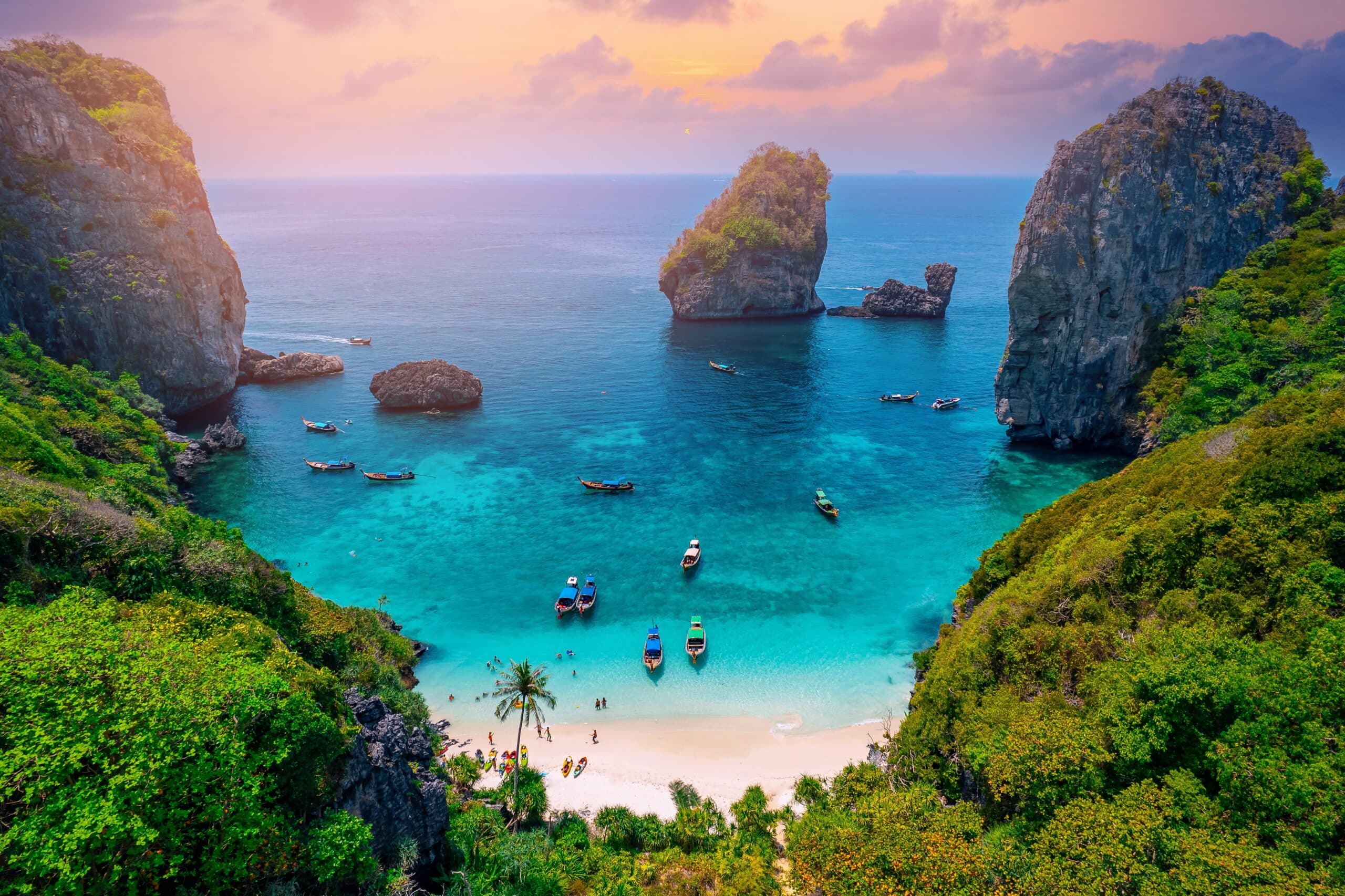
6. Koh Phi Phi
Koh Phi Phi lies in the Andaman Sea between Phuket and Krabi Province. Geography here is limestone-karst and insular, defined by steep cliffs rising directly from turquoise waters.
The main islands, Phi Phi Don and Phi Phi Leh, are mountainous with minimal flat terrain. Geography reinforces concentrated settlement on narrow sandy isthmuses.
Sheer limestone formations dominate the skyline. Geography binds marine ecosystems to coral reefs and sheltered bays formed by eroded rock walls.
Monsoon patterns alternate between southwest and northeast seasons, influencing wave exposure. Geography requires adaptation to seasonal sea conditions and coastal erosion risks.
Access depends entirely on boat transport. Geography emphasizes maritime connectivity rather than land infrastructure.
Koh Phi Phi inspires through vertical rock formations and enclosed lagoons. The land teaches endurance through adaptation to limited freshwater sources and restricted buildable space, showing how resilience develops where human activity fits within fragile island ecosystems.
Endurance here is coastal and ecological. Geography requires reef conservation, slope stability management, and protection against storm surge. Stability depends on maintaining marine biodiversity and limiting environmental strain.
Koh Phi Phi reflects a Thailand shaped by Andaman limestone geology and tropical maritime forces. Visitors encounter a landscape where resilience emerges from coexistence between towering karst cliffs and surrounding sea.
5. Kanchanaburi
Kanchanaburi lies in western Thailand near the Myanmar border. Geography here is riverine and mountainous, shaped by the confluence of the Khwae Noi and Khwae Yai rivers.
The city stands at the meeting point of these waterways. Geography reinforces settlement at river junctions and fertile banks.
Surrounding terrain transitions into forested hills and limestone ranges. Geography binds watershed stability to upland forest cover.
Monsoon rains increase river flow and influence agricultural cycles. Geography requires flood awareness and erosion management in adjacent highlands.
Road and rail routes extend westward through mountain passes. Geography emphasizes valley corridors over rugged upland routes.
Kanchanaburi inspires through river confluence and mountainous backdrop. The land teaches endurance through adaptation to fluvial change and forested terrain, showing how resilience develops where rivers carve through hills.
Endurance here is hydrological and ecological. Geography requires responsible forest management and river system protection. Stability depends on balancing watershed preservation with development.
Kanchanaburi reflects a Thailand shaped by western highlands and converging river systems. Visitors encounter a landscape where resilience emerges from coexistence between flowing water and rising limestone ridges.
4. Koh Lanta
Koh Lanta lies off the Andaman coast in Krabi Province. Geography here is elongated and insular, characterized by forested hills running north to south.
The island’s western coast features long sandy beaches facing the open sea. Geography reinforces wave exposure during southwest monsoon months.
Interior terrain rises gently into wooded hills. Geography binds freshwater streams and soil stability to upland vegetation.
Seasonal rainfall alternates with dry periods. Geography requires adaptation to fluctuating water availability and coastal erosion.
A single primary road follows the island’s length. Geography emphasizes linear development constrained by narrow coastal plains.
Koh Lanta inspires through extended shoreline continuity and gradual topographic rise. The land teaches endurance through adaptation to monsoon cycles and limited insular resources, showing how resilience develops where elongated islands meet open sea.
Endurance here is coastal and ecological. Geography requires mangrove protection, beach preservation, and freshwater conservation. Stability depends on safeguarding fragile coastal ecosystems.
Koh Lanta reflects a Thailand shaped by Andaman coastal geography and tropical climate rhythms. Visitors encounter a landscape where resilience emerges from coexistence between forested hills and expansive beaches.
3. Hua Hin
Hua Hin lies along the western shore of the Gulf of Thailand in Prachuap Khiri Khan Province. Geography here is coastal and gently contoured, shaped by long beaches bordered by low hills.
The shoreline extends in a smooth arc facing east. Geography reinforces exposure to seasonal monsoon winds and tidal variation.
Behind the coast, modest limestone hills rise intermittently. Geography binds settlement to flat coastal plains while upland ridges define natural boundaries.
The climate alternates between dry and wet monsoon seasons. Geography requires adaptation to coastal erosion and periodic heavy rainfall.
Road and rail links connect Hua Hin northward to Bangkok and southward along the peninsula. Geography emphasizes linear transport along the Gulf shoreline.
Hua Hin inspires through open horizons and gradual transitions between sea and hills. The land teaches endurance through adaptation to coastal forces and seasonal climate rhythms, showing how resilience develops where shoreline and upland terrain meet.
Endurance here is coastal and environmental. Geography requires shoreline stabilization, mangrove conservation, and water resource management. Stability depends on balancing marine exposure with sustainable land use.
Hua Hin reflects a Thailand shaped by Gulf coastline geography and monsoon cycles. Visitors encounter a landscape where resilience emerges from coexistence between sandy shores and modest limestone elevations.
2. Khao Sok National Park
Khao Sok National Park lies in Surat Thani Province in southern Thailand. Geography here is rainforest and karst, characterized by limestone mountains rising above dense tropical forest.
The park’s terrain is rugged and steep. Geography reinforces watershed formation and biodiversity concentration within forested valleys.
Cheow Lan Lake occupies a central basin surrounded by cliffs. Geography binds freshwater systems to mountainous catchment areas.
Heavy monsoon rainfall sustains dense vegetation. Geography requires adaptation to saturated soils and seasonal river fluctuations.
Access roads approach from coastal lowlands but interior zones remain limited to boat or foot travel. Geography emphasizes natural barriers over extensive infrastructure.
Khao Sok inspires through vertical limestone formations and rainforest canopy depth. The land teaches endurance through adaptation to humid climate and rugged relief, showing how resilience develops where forest ecosystems anchor mountainous terrain.
Endurance here is ecological and hydrological. Geography requires preservation of rainforest cover and protection of freshwater basins. Stability depends on maintaining biodiversity and watershed integrity.
Khao Sok National Park reflects a Thailand shaped by southern rainforest geography and monsoon intensity. Visitors encounter a landscape where resilience emerges from coexistence between limestone peaks and dense tropical forest.
1. Sukhothai
Sukhothai lies in north-central Thailand within a fertile river plain. Geography here is lowland and alluvial, framed by distant hills and irrigated agricultural fields.
The Yom River flows nearby, contributing to soil fertility. Geography reinforces agricultural settlement and water-based land management.
Flat terrain allows expansive cultivation. Geography binds economic activity to predictable seasonal flood cycles.
Monsoon rainfall influences river levels and crop timing. Geography requires adaptation to both drought and flood variability.
Road networks connect Sukhothai to northern and central provinces across relatively open plains. Geography emphasizes ease of inland connectivity.
Sukhothai inspires through expansive flatland symmetry and distant mountain silhouettes. The land teaches endurance through adaptation to river cycles and seasonal rainfall, showing how resilience develops where fertile plains meet reliable water sources.
Endurance here is agricultural and hydrological. Geography requires irrigation systems and floodplain management. Stability depends on preserving river health and soil productivity.
Sukhothai reflects a Thailand shaped by central plains geography and monsoon-fed rivers. Visitors encounter a landscape where resilience emerges from coexistence between open farmland and gently rising highlands.