
Laos lies in the heart of mainland Southeast Asia, bordered by China to the north, Vietnam to the east, Cambodia to the south, Thailand to the west, and Myanmar to the northwest. It is the only landlocked country in the region. Geography defines Laos through mountains, river valleys, and dense forest coverage.
The Mekong River forms the country’s dominant geographic spine. Flowing from north to south, it shapes settlement, agriculture, and transportation. Most population centers align along the Mekong corridor and its tributaries. Geography reinforces river-based living patterns and fertile floodplains.
Northern Laos is mountainous, with rugged terrain and steep slopes. The Annamite Range stretches along the eastern border with Vietnam. Geography binds watershed formation to monsoon rainfall, creating numerous streams that feed into the Mekong basin.
Central Laos transitions into rolling plateaus and valley systems. Southern Laos widens into broader river plains and elevated basalt plateaus. Geography emphasizes vertical contrast between uplands and lowlands.
Climate follows tropical monsoon patterns. Rainy and dry seasons strongly influence agricultural cycles and river levels. Geography requires adaptation to seasonal shifts in water flow and soil moisture.
Laos inspires through natural continuity and spatial openness. The land teaches endurance through adaptation to elevation, forest ecology, and river systems. Resilience here emerges from harmony with terrain rather than domination of it.
Endurance in Laos is ecological and hydrological. Stability depends on forest conservation, watershed protection, and sustainable river management.
Laos reflects a country shaped by mountains and rivers more than urban concentration. Visitors encounter a landscape where resilience develops through coexistence with terrain, water, and seasonal rhythm.
19. Luang Prabang
Luang Prabang lies in northern Laos at the confluence of the Mekong and Nam Khan rivers. Geography here is riverine and mountainous, with settlement positioned between flowing water and forested hills.
The city occupies a narrow peninsula formed by river convergence. Geography reinforces defensive positioning and natural boundaries created by water on three sides. Hills rise immediately behind the urban core.
The Mekong provides longitudinal flow, while the Nam Khan curves around the eastern edge. Geography binds urban development to elevated ground slightly above seasonal flood levels.
Surrounding terrain consists of steep slopes and dense vegetation. Geography emphasizes compact settlement shaped by limited flat land.
Rainfall influences river levels and seasonal greenery. Geography requires infrastructure aligned with slope gradients and flood cycles.
Luang Prabang inspires through river harmony and topographic enclosure. The land teaches endurance through adaptation to narrow terrain and hydrological rhythm, showing how resilience develops where settlement fits natural contours.
Endurance here is watershed-based. Geography requires riverbank stability, erosion management, and forest protection in surrounding hills. Stability depends on maintaining ecological balance between upland runoff and river systems.
Luang Prabang reflects a Laos shaped by river convergence and mountain enclosure. Visitors encounter a landscape where resilience emerges through coexistence between water, elevation, and seasonal flow.
18. Vientiane
Vientiane lies along a broad bend of the Mekong River in central Laos, directly opposite Thailand. Geography here is defined by low floodplains, river terraces, and gently rising hinterland.
The Mekong shapes the western boundary of the city. Geography reinforces linear expansion parallel to the river rather than vertical growth. Wide alluvial plains support agriculture and settlement.
Unlike the mountainous north, Vientiane stands on relatively flat terrain. Geography binds urban form to open space and broad horizons. Seasonal flooding influences riverbank stabilization and land use planning.
Inland areas gradually transition into rolling hills. Geography emphasizes gentle elevation change compared to more rugged provinces.
Climate follows the tropical monsoon cycle. Geography requires adaptation to rainy-season water levels and dry-season heat.
Vientiane inspires through openness and river continuity. The land teaches endurance through adaptation to floodplain geography and seasonal hydrology, showing how resilience develops where urban settlement aligns with a major river corridor.
Endurance here is fluvial and infrastructural. Geography requires careful flood management and riverbank protection. Stability depends on maintaining ecological balance along the Mekong.
Vientiane reflects a Laos shaped by lowland river geography and gradual expansion across fertile plains. Visitors encounter a landscape that reinforces endurance as coexistence between settlement and river rhythm.
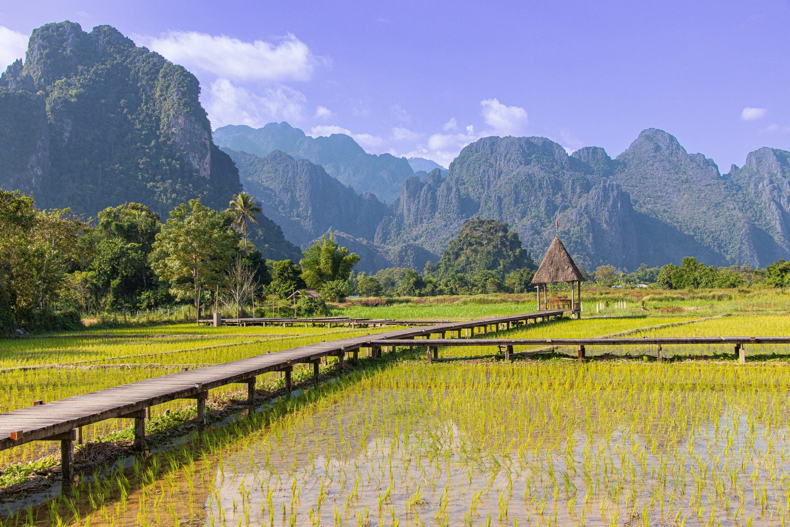
17. Vang Vieng
Vang Vieng lies in central Laos along the Nam Song River. Geography here is dramatic and karstic, defined by limestone mountains rising abruptly from flat agricultural valleys.
Towering limestone formations dominate the skyline. Geography reinforces vertical contrast between jagged peaks and fertile floodplain fields.
The Nam Song River flows gently through the valley. Geography binds settlement to riverbanks and flat land suitable for cultivation.
Karst geology produces caves, sinkholes, and underground drainage systems. Geography emphasizes porous limestone terrain shaped by erosion over millennia.
The valley floor remains relatively narrow. Geography requires adaptation to limited flat space between steep formations.
Vang Vieng inspires through geological contrast and vertical drama. The land teaches endurance through adaptation to karst topography, showing how resilience develops where communities align with valley systems beneath towering rock.
Endurance here is geological and watershed-based. Geography requires preservation of limestone ecosystems and careful land management to prevent erosion.
Vang Vieng reflects a Laos shaped by karst landscapes and river valleys. Visitors encounter a landscape where resilience emerges from coexistence between fertile plains and dramatic limestone peaks.
16. Pakse
Pakse lies in southern Laos at the confluence of the Mekong and Xe Don rivers. Geography here is river-based and transitional, connecting upland plateaus with lowland floodplains.
The Mekong forms the western edge, while the Xe Don flows from eastern highlands. Geography reinforces Pakse’s role as a gateway between plateau and plain.
South and east of the city rises the Bolaven Plateau. Geography binds rainfall patterns and fertile volcanic soils to highland agriculture.
The immediate urban area sits on relatively flat ground above typical flood levels. Geography emphasizes confluence positioning and watershed integration.
Transport routes extend toward plateau elevations and along the Mekong corridor. Geography shapes Pakse as a connective node between diverse terrains.
Pakse inspires through convergence and transition. The land teaches endurance through adaptation to river junctions and upland access, showing how resilience develops where multiple landscapes meet.
Endurance here is hydrological and agricultural. Geography requires management of riverbanks and plateau runoff. Stability depends on balancing upland soil conservation with lowland settlement needs.
Pakse reflects a Laos shaped by confluence geography and plateau proximity. Visitors encounter a landscape where resilience emerges from coexistence between rivers, uplands, and fertile plains.
15. Phonsavan
Phonsavan lies in northeastern Laos on the Xiangkhoang Plateau. Geography here is elevated and expansive, defined by rolling grasslands, scattered hills, and broad open skies.
The plateau stands significantly higher than the Mekong lowlands. Geography reinforces cooler temperatures and seasonal variation distinct from river valleys.
Undulating terrain surrounds the settlement. Geography binds habitation to relatively flat stretches within a wider upland basin.
The region’s soils support pasture and limited agriculture. Geography emphasizes openness rather than dense forest cover common in other provinces.
Seasonal monsoon rains influence vegetation cycles. Geography requires adaptation to periods of heavy rainfall followed by extended dry conditions.
Phonsavan inspires through highland vastness and spatial clarity. The land teaches endurance through adaptation to elevation and seasonal shifts, showing how resilience develops in upland plateau environments.
Endurance here is climatic and agricultural. Geography requires soil management and watershed stability to prevent erosion across open grasslands. Stability depends on preserving plateau ecosystems.
Phonsavan reflects a Laos shaped by upland geography rather than riverine concentration. Visitors encounter a landscape where resilience emerges from coexistence between elevation, open terrain, and seasonal rhythm.
14. Nong Khiaw
Nong Khiaw lies in northern Laos along the Nam Ou River. Geography here is defined by steep limestone mountains enclosing a narrow river valley.
The Nam Ou flows between sharply rising karst formations. Geography reinforces settlement along limited flat ground adjacent to the riverbanks.
Towering peaks frame the horizon on both sides. Geography binds habitation to valley corridors carved by water through resistant limestone.
River flow patterns determine agricultural activity. Geography emphasizes the importance of floodplain soils within otherwise rugged terrain.
Access routes follow the river’s course. Geography requires adaptation to limited transportation corridors shaped by mountainous barriers.
Nong Khiaw inspires through vertical enclosure and river continuity. The land teaches endurance through adaptation to confined valleys and karst landscapes, showing how resilience develops where communities align with narrow but fertile river systems.
Endurance here is hydrological and geological. Geography requires slope stability, forest preservation, and riverbank protection. Stability depends on maintaining ecological balance between upland runoff and valley agriculture.
Nong Khiaw reflects a Laos shaped by mountain-river interaction. Visitors encounter a landscape where resilience emerges from coexistence between steep limestone walls and flowing water.
13. Savannakhet
Savannakhet lies in central-southern Laos along the Mekong River. Geography here is characterized by broad plains, river terraces, and gently rolling hinterland.
The Mekong forms the western boundary. Geography reinforces linear settlement aligned with the river corridor.
Extensive flatlands extend eastward. Geography binds agriculture and infrastructure to fertile soils deposited by seasonal flooding.
The region’s elevation is modest compared to northern provinces. Geography emphasizes accessibility and gradual transitions rather than steep relief.
Seasonal rainfall shapes cropping cycles. Geography requires adaptation to wet-season river expansion and dry-season heat.
Savannakhet inspires through spatial openness and agricultural continuity. The land teaches endurance through adaptation to floodplain ecology, showing how resilience develops where settlement harmonizes with a major river system.
Endurance here is fluvial and agricultural. Geography requires careful floodplain management and soil conservation. Stability depends on maintaining river health and protecting productive farmland.
Savannakhet reflects a Laos shaped by lowland geography and Mekong continuity. Visitors encounter a landscape where resilience emerges from coexistence between wide plains and river rhythm.
12. Muang Ngoi
Muang Ngoi lies in northern Laos along the Nam Ou River, upstream from Nong Khiaw. Geography here is defined by isolation, steep limestone mountains, and a narrow river corridor.
The Nam Ou provides the primary access route. Geography reinforces river dependency, as surrounding mountains restrict overland travel.
Sheer karst cliffs rise abruptly from the valley floor. Geography binds settlement to a limited strip of flat land between water and rock.
Dense forest covers much of the surrounding slopes. Geography emphasizes watershed preservation and slope stability in a fragile mountain environment.
Seasonal monsoon rains influence river levels and access conditions. Geography requires adaptation to fluctuating water flow and potential landslides on steep terrain.
Muang Ngoi inspires through remoteness and enclosure. The land teaches endurance through adaptation to geographic isolation, showing how resilience develops where communities align entirely with a river-based corridor.
Endurance here is hydrological and logistical. Geography requires careful resource management and sustainable land use. Stability depends on maintaining forest cover and protecting the river ecosystem.
Muang Ngoi reflects a Laos shaped by mountain confinement and river reliance. Visitors encounter a landscape where resilience emerges from coexistence between towering limestone walls and a single waterway lifeline.
11. Champasak
Champasak lies in southern Laos along the Mekong River, south of Pakse. Geography here is riverine and transitional, connecting fertile lowlands with the Bolaven Plateau hinterland.
The Mekong defines the western boundary. Geography reinforces agricultural activity along its floodplain soils.
Eastward, terrain gradually rises toward upland plateaus. Geography binds settlement to the interface between lowland riverbanks and higher volcanic soils.
Seasonal flooding shapes land use patterns. Geography emphasizes adaptation to annual water cycles.
The surrounding region includes forest patches and cultivated land. Geography requires soil conservation to protect against erosion from plateau runoff.
Champasak inspires through geographic balance between river and upland. The land teaches endurance through adaptation to confluence landscapes, showing how resilience develops where floodplain agriculture meets plateau ecology.
Endurance here is fluvial and agrarian. Geography requires sustainable irrigation practices and watershed protection. Stability depends on maintaining equilibrium between Mekong flow and upland drainage.
Champasak reflects a Laos shaped by river connectivity and plateau proximity. Visitors encounter a landscape where resilience emerges from coexistence between expansive floodplains and rising highlands.
10. Vieng Xai
Vieng Xai lies in northeastern Laos near the Vietnamese border. Geography here is mountainous and cavernous, defined by limestone formations and narrow valleys.
Steep karst mountains dominate the region. Geography reinforces isolation and limited valley settlement.
Natural caves are widespread due to limestone geology. Geography binds habitation and shelter to cavern-rich terrain.
Valleys between mountains provide small pockets of arable land. Geography emphasizes confinement and watershed dependency.
Rainfall patterns influence slope vegetation and river flow. Geography requires adaptation to steep gradients and limited flat ground.
Vieng Xai inspires through rugged enclosure and geological complexity. The land teaches endurance through adaptation to mountainous confinement, showing how resilience develops where communities align with protected valleys and limestone shelter.
Endurance here is geological and hydrological. Geography requires forest preservation and slope stabilization. Stability depends on managing upland runoff and preventing erosion.
Vieng Xai reflects a Laos shaped by karst mountains and enclosed valleys. Visitors encounter a landscape where resilience emerges from coexistence between towering limestone formations and narrow fertile corridors.
9. Thakhek
Thakhek lies in central Laos along the Mekong River opposite Thailand. Geography here is defined by riverfront plains and nearby limestone formations extending eastward into mountainous terrain.
The Mekong shapes the western edge of the town. Geography reinforces linear settlement along elevated riverbanks safe from seasonal flooding.
To the east, karst landscapes rise abruptly from flat plains. Geography binds agricultural activity to fertile river terraces while limestone hills limit inland expansion.
Seasonal monsoon rainfall influences river levels and soil moisture. Geography requires adaptation to wet-season flooding and dry-season heat.
Transport routes follow the Mekong corridor and curve into the limestone interior. Geography emphasizes connectivity between river lowlands and mountainous hinterland.
Thakhek inspires through contrast between calm riverfront and rugged uplands. The land teaches endurance through adaptation to floodplain geography and karst proximity, showing how resilience develops where fertile soil meets geological elevation.
Endurance here is fluvial and geological. Geography requires riverbank stabilization and slope protection. Stability depends on preserving both floodplain fertility and upland forest cover.
Thakhek reflects a Laos shaped by the meeting of major river systems and limestone terrain. Visitors encounter a landscape where resilience emerges from coexistence between wide plains and dramatic karst formations.
8. Bolaven Plateau
Bolaven Plateau lies in southern Laos east of Pakse. Geography here is elevated and volcanic, characterized by fertile basalt soils, rolling highlands, and numerous waterfalls.
The plateau stands higher than surrounding Mekong lowlands. Geography reinforces cooler temperatures and increased rainfall relative to adjacent plains.
Volcanic soil supports diversified agriculture. Geography binds productivity to mineral-rich earth formed through ancient eruptions.
Rivers originate across the plateau and descend sharply toward the Mekong. Geography emphasizes watershed formation and waterfall development where elevation drops suddenly.
Dense vegetation thrives due to heavy monsoon rainfall. Geography requires soil conservation to prevent erosion along slopes.
Movement across the plateau follows winding roads tracing undulating terrain. Geography emphasizes gradual ascent from lowlands into cooler uplands.
The Bolaven Plateau inspires through elevation and ecological richness. The land teaches endurance through adaptation to highland climate and volcanic soil conditions, showing how resilience develops where altitude shapes agriculture and water systems.
Endurance here is agricultural and hydrological. Geography requires forest preservation and careful water management. Stability depends on protecting plateau ecosystems that feed downstream river basins.
The Bolaven Plateau reflects a Laos shaped by volcanic history and highland fertility. Visitors encounter a landscape where resilience emerges from coexistence between elevation, rainfall, and fertile soil.
7. Si Phan Don
Si Phan Don lies in southern Laos near the Cambodian border. Geography here is fluvial and archipelagic, defined by the Mekong River widening into multiple braided channels and islands.
The name means “Four Thousand Islands,” reflecting extensive river fragmentation. Geography reinforces settlement on stable islands above typical flood levels.
During the rainy season, water spreads across channels and submerges smaller sandbanks. Geography binds habitation to higher ground shaped by sediment accumulation.
The surrounding terrain remains flat, with minimal elevation change. Geography emphasizes river dynamics rather than mountain relief.
River flow is powerful in certain channels, forming rapids and waterfalls where bedrock interrupts sediment layers. Geography requires adaptation to fluctuating water levels.
Si Phan Don inspires through river multiplicity and seasonal transformation. The land teaches endurance through alignment with shifting waterways, showing how resilience develops where communities adapt to island-based living.
Endurance here is sedimentary and hydrological. Geography requires careful riverbank management and protection of aquatic ecosystems. Stability depends on maintaining natural flow patterns across the Mekong basin.
Si Phan Don reflects a Laos shaped by river expansion and island formation. Visitors encounter a landscape where resilience emerges from coexistence between braided waterways and low-lying islands.
6. Phongsali
Phongsali lies in the far north of Laos near the Chinese and Vietnamese borders. Geography here is mountainous and elevated, defined by steep ridgelines and cool highland climate.
The town sits at over 1,400 meters above sea level. Geography reinforces cooler temperatures compared to lowland Laos and frequent mist along mountain slopes.
Surrounding terrain consists of layered hills and narrow valleys. Geography binds settlement to limited flat ridges and terraced hillsides.
Monsoon rainfall influences slope stability and river formation. Geography emphasizes watershed protection in upland regions feeding downstream basins.
Agriculture adapts to elevation through terrace cultivation. Geography requires soil conservation to prevent erosion on steep gradients.
Road access winds through mountain passes. Geography reinforces isolation and seasonal vulnerability during heavy rains.
Phongsali inspires through altitude and remoteness. The land teaches endurance through adaptation to mountain confinement, showing how resilience develops where communities align with highland climate and terrain.
Endurance here is climatic and topographical. Geography requires forest preservation and careful land management. Stability depends on protecting upland ecosystems that regulate water flow toward major rivers.
Phongsali reflects a Laos shaped by northern highlands and borderland geography. Visitors encounter a landscape where resilience emerges from coexistence between cool mountain air and steep, forested slopes.
5. Savannakhet
Savannakhet lies in central-southern Laos along the Mekong River opposite Thailand. Geography here is characterized by broad plains and riverine connectivity.
The Mekong forms the western boundary. Geography reinforces linear development along elevated riverbanks safe from annual floods.
The surrounding terrain is relatively flat compared to northern Laos. Geography binds agriculture to expansive lowland soils enriched by seasonal flooding.
Savannakhet occupies a strategic mid-point between northern and southern Laos. Geography emphasizes its role as a transport corridor along the river plain.
Monsoon cycles influence soil moisture and water levels. Geography requires adaptation to seasonal hydrological change.
Inland areas transition gradually into forest and low hills. Geography reinforces a balance between cultivated land and remaining woodland.
Savannakhet inspires through openness and spatial continuity. The land teaches endurance through adaptation to floodplain conditions, showing how resilience develops where settlement follows major river corridors.
Endurance here is fluvial and agricultural. Geography requires riverbank protection and soil management. Stability depends on sustaining both farmland productivity and watershed health.
Savannakhet reflects a Laos shaped by river plains and cross-border connectivity. Visitors encounter a landscape where resilience emerges from coexistence between expansive lowlands and the steady flow of the Mekong.
4. Nong Khiaw
Nong Khiaw lies in northern Laos along the Nam Ou River. Geography here is dramatic and vertical, defined by towering limestone mountains and a narrow river valley.
The Nam Ou bisects the settlement. Geography reinforces village development along both riverbanks connected by a bridge spanning the waterway.
Karst peaks rise sharply from the valley floor. Geography binds habitation to limited flat land between steep rock faces and river edges.
Dense vegetation covers surrounding slopes. Geography emphasizes biodiversity and watershed regulation in mountainous terrain.
Seasonal rainfall affects river flow and slope stability. Geography requires adaptation to monsoon conditions and potential landslides.
Transport routes follow the valley’s natural corridor. Geography reinforces movement constrained by mountains.
Nong Khiaw inspires through scale and enclosure. The land teaches endurance through adaptation to confined valley geography, showing how resilience develops where communities align with both river systems and limestone formations.
Endurance here is geological and hydrological. Geography requires forest conservation and slope stabilization. Stability depends on maintaining ecological balance between upland runoff and river flow.
Nong Khiaw reflects a Laos shaped by karst landscapes and river corridors. Visitors encounter a landscape where resilience emerges from coexistence between towering limestone peaks and a winding mountain river.
3. Bokeo Nature Reserve
Bokeo Nature Reserve lies in northwestern Laos near the Thai border. Geography here is mountainous and forested, defined by dense canopy, rugged terrain, and river valleys feeding the Mekong basin.
The reserve sits within upland hills shaped by tectonic uplift. Geography reinforces biodiversity through varied elevation and intact forest cover.
River systems cut through steep slopes, creating layered valleys. Geography binds ecological diversity to watershed protection in mountainous terrain.
Heavy monsoon rainfall nourishes evergreen forests. Geography emphasizes moisture retention within dense vegetation and fertile forest soils.
Human settlement is limited due to steep gradients. Geography requires conservation strategies aligned with slope stability and erosion prevention.
Trails follow ridgelines and forest clearings shaped by natural contours. Geography reinforces minimal-impact movement within protected ecosystems.
Bokeo inspires through elevation and ecological density. The land teaches endurance through forest resilience and watershed balance, showing how stability develops where mountains sustain biodiversity and water systems simultaneously.
Endurance here is ecological and geological. Geography requires strict forest preservation to maintain slope integrity and river quality. Stability depends on safeguarding upland habitats that regulate downstream environments.
Bokeo Nature Reserve reflects a Laos shaped by mountain forests and ecological preservation. Visitors encounter a landscape where resilience emerges from coexistence between highland terrain and dense tropical canopy.
2. Nam Et–Phou Louey National Park
Nam Et–Phou Louey National Park lies in northeastern Laos along the Vietnamese border. Geography here is mountainous and expansive, characterized by forested ridges, deep valleys, and significant elevation change.
The park encompasses one of Laos’s largest protected upland areas. Geography reinforces ecological continuity across mountainous terrain.
Rivers originate within forested slopes and descend into valley systems. Geography binds watershed stability to intact forest cover.
Elevation influences temperature variation and habitat diversity. Geography emphasizes vertical zoning within mountain ecosystems.
Monsoon rains shape river flow and slope conditions. Geography requires conservation aligned with seasonal hydrological cycles.
Settlement density remains low due to steep terrain. Geography reinforces preservation through limited agricultural expansion.
Nam Et–Phou Louey inspires through scale and remoteness. The land teaches endurance through ecological adaptation across altitude gradients, showing how resilience develops where forest systems protect water and soil integrity.
Endurance here is climatic and environmental. Geography requires sustained forest management and watershed protection. Stability depends on maintaining uninterrupted habitat corridors across mountainous landscapes.
The park reflects a Laos shaped by northeastern highlands and biodiversity preservation. Visitors encounter a landscape where resilience emerges from coexistence between elevation, rainfall, and forest continuity.
1. Khammouane Limestone Forest
Khammouane Limestone Forest lies in central Laos east of the Mekong. Geography here is dominated by extensive karst formations, underground river systems, and forested limestone mountains.
Towering limestone cliffs define the region. Geography reinforces dramatic vertical relief shaped by long-term erosion.
Caves and subterranean rivers cut through porous rock. Geography binds water systems to underground channels typical of karst environments.
Surface vegetation clings to rocky slopes and narrow valleys. Geography emphasizes adaptation of plant life to thin soils and mineral-rich substrate.
Seasonal rainfall filters rapidly through limestone, influencing groundwater systems. Geography requires protection of fragile karst hydrology.
Human habitation concentrates in limited valley floors. Geography reinforces spatial restriction due to steep and rugged terrain.
Khammouane inspires through geological complexity. The land teaches endurance through adaptation to porous rock and vertical landscapes, showing how resilience develops where water and stone interact over millennia.
Endurance here is geological and hydrological. Geography requires safeguarding cave systems and maintaining forest cover to prevent erosion. Stability depends on protecting both surface ecosystems and underground waterways.
Khammouane Limestone Forest reflects a Laos shaped by karst processes and ecological adaptation. Visitors encounter a landscape where resilience emerges from coexistence between towering limestone peaks and hidden river systems.