
Cambodia lies in mainland Southeast Asia between Thailand, Laos, and Vietnam, with a southern coastline along the Gulf of Thailand. Geography here is river-centered and basin-shaped. Much of the country consists of low plains structured around the Mekong River and the Tonle Sap system.
The Mekong flows from north to south, crossing eastern Cambodia before entering Vietnam’s delta. Geography binds national life to this river corridor. The Tonle Sap Lake, positioned centrally, expands and contracts dramatically with seasonal monsoon flow.
Mountain ranges frame the plains. The Cardamom Mountains rise in the southwest, while the Dangrek Mountains form a northern boundary. Geography reinforces a bowl-like configuration, with water draining toward central lowlands.
Seasonal monsoon cycles dominate climate patterns. Geography shapes agriculture through predictable wet and dry periods, supporting rice cultivation across fertile floodplains.
Settlement and movement historically followed river routes. Geography emphasizes water-based connectivity over rugged overland passage. The Mekong and Tonle Sap together create one of Southeast Asia’s most dynamic freshwater systems.
Cambodia inspires through hydrological rhythm. The land teaches endurance through adaptation to seasonal expansion and retreat of water. Resilience here develops through alignment with flood cycles rather than resistance to them.
Endurance is fluvial and seasonal. Geography binds agricultural productivity to river pulse and lake reversal. Stability depends on preserving watershed balance upstream and floodplain integrity downstream.
Cambodia reflects a Southeast Asian nation whose resilience emerges from river basin geography shaped by monsoon and sediment. Visitors encounter a landscape that reinforces endurance as coexistence between expansive plains, inland water systems, and framing mountain barriers.
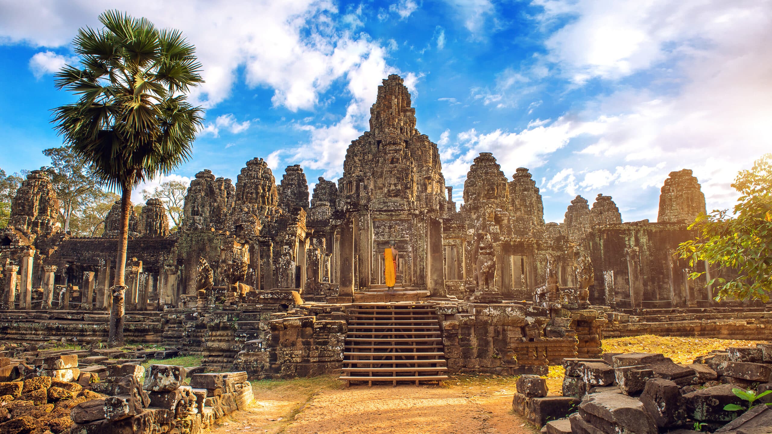
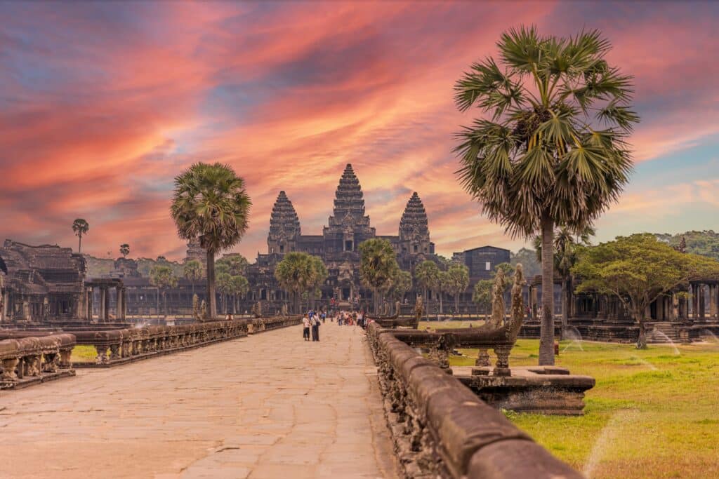
19. Angkor
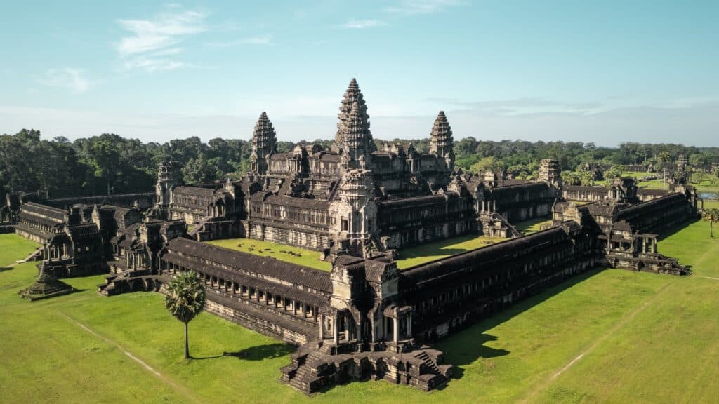
Angkor lies northwest of the Tonle Sap Lake near present-day Siem Reap. Geography here is alluvial and forest-edged. The region occupies gently sloping land between lake basin and low hills.
The ancient city developed within a fertile plain enriched by seasonal flooding. Geography enabled construction of extensive reservoirs and canals designed to manage monsoon water. Barays and moats integrated directly into the terrain.
The proximity to Tonle Sap allowed agricultural expansion supported by predictable flood cycles. Geography reinforced large-scale rice production through controlled irrigation.
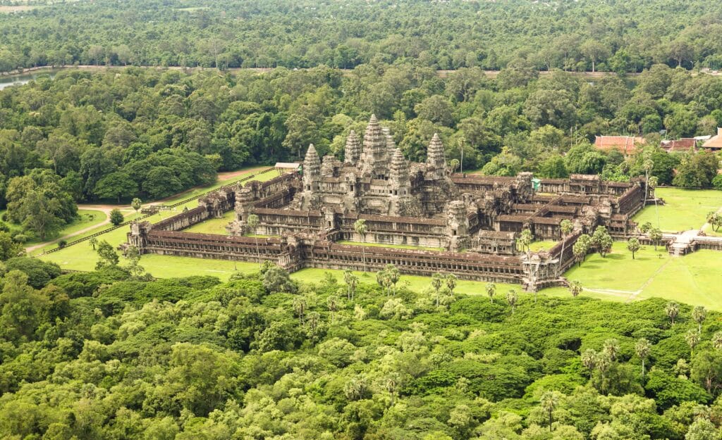
Low sandstone hills nearby provided construction material. Geography shaped architectural scale through accessible natural resources and relatively flat building surfaces.
Movement across Angkor follows broad causeways aligned with cardinal directions. Geography emphasizes horizontal expansion across plain rather than vertical adaptation to elevation.
Angkor inspires through engineered alignment with environment. The land teaches endurance through water management, showing how resilience develops when seasonal flow is organized into stable infrastructure.
Endurance here is hydraulic and structural. Geography required continuous maintenance of reservoirs and canals to sustain urban concentration. Stability depended on synchronizing human engineering with monsoon timing.
Angkor reflects a Cambodia where resilience once manifested through integration of architecture and hydrology. Visitors encounter a landscape that reinforces endurance as balance between monumental construction and surrounding plain shaped by seasonal water.
18. Phnom Penh
Phnom Penh lies at the confluence of the Mekong, Tonle Sap, and Bassac rivers in south-central Cambodia. Geography here is fluvial and low-lying. The city occupies one of the most strategic river junctions in mainland Southeast Asia.
The Tonle Sap River reverses direction seasonally, flowing northward into the lake during monsoon and southward toward the Mekong during dry months. Geography reinforces Phnom Penh’s role as a hydrological crossroads.
The surrounding terrain is predominantly flat, allowing expansion across floodplain. Geography shapes urban planning through levees and elevated construction to mitigate seasonal inundation.
Riverbanks form natural corridors for transportation and trade. Geography historically favored boat-based movement linking inland settlements with coastal outlets.
Rainfall concentration during monsoon months influences drainage systems. Geography binds infrastructure resilience to careful management of rising water levels.
Phnom Penh inspires through convergence. The land teaches endurance through coexistence with powerful river forces, showing how resilience develops at meeting points of major waterways.
Endurance here is confluence-based and sedimentary. Geography requires balancing river traffic, flood risk, and floodplain fertility. Stability depends on preserving river flow integrity upstream.
Phnom Penh reflects a Cambodia shaped by the intersection of its primary rivers. Visitors encounter a landscape that reinforces endurance as adaptation within one of Southeast Asia’s most dynamic river junctions.
17. Battambang
Battambang lies in northwestern Cambodia between the Tonle Sap basin and the Thai border. Geography here is agricultural and gently undulating. The province occupies part of Cambodia’s fertile northwest plain, shaped by sediment deposited through seasonal flooding.
Low hills rise gradually westward toward the Cardamom foothills. Geography reinforces agricultural productivity through nutrient-rich soil and accessible irrigation. Rice cultivation dominates the surrounding landscape, supported by canals and small rivers.
The Sangker River flows through the city, connecting inland fields to the Tonle Sap Lake. Geography binds settlement patterns to this watercourse, reinforcing riverbank concentration and fertile floodplain development.
Seasonal monsoon rains replenish soil but also require flood management. Geography shapes settlement through elevation adjustments and drainage adaptation.
Movement through Battambang follows relatively straight road corridors across flat terrain. Geography emphasizes horizontal expansion rather than vertical limitation.
Battambang inspires through agricultural continuity. The land teaches endurance through alignment with seasonal water cycles, showing how resilience forms where soil fertility depends on annual renewal.
Endurance here is sedimentary and agrarian. Geography requires careful maintenance of irrigation systems to sustain productivity. Stability depends on balancing flood control with natural soil replenishment.
Battambang reflects a Cambodia where resilience emerges from fertile plains shaped by monsoon and river flow. Visitors encounter a landscape that reinforces endurance as coexistence between cultivated land and seasonal inundation.
16. Kampot
Kampot lies in southern Cambodia near the Gulf of Thailand. Geography here is coastal and riverine. The Kampot River flows from inland hills toward the sea, creating fertile lowland zones along its banks.
The Elephant Mountains rise to the west, forming a protective barrier that influences rainfall distribution. Geography reinforces a transition zone between mountainous terrain and coastal plain.
Salt flats and estuarine systems characterize parts of the shoreline. Geography shapes agriculture and aquaculture through brackish water interaction.
Seasonal monsoon patterns bring substantial rainfall, especially along the mountain slopes. Geography binds freshwater availability to upland watershed health.
Movement through Kampot follows river channels and coastal roads linking inland settlements to maritime routes. Geography emphasizes gradual descent from highland to sea.
Kampot inspires through transition. The land teaches endurance through adaptation to changing terrain—from mountain slope to estuary—showing how resilience develops across ecological gradients.
Endurance here is estuarine and climatic. Geography requires balance between freshwater flow and coastal salinity. Stability depends on protecting both upstream forests and downstream wetlands.
Kampot reflects a Cambodia where resilience forms at the intersection of river, mountain, and sea. Visitors encounter a landscape that reinforces endurance as coexistence between elevated watershed and coastal plain.
15. Koh Rong
Koh Rong lies off Cambodia’s southwestern coast in the Gulf of Thailand. Geography here is insular and maritime. The island consists of forested hills surrounded by sandy beaches and shallow turquoise waters.
The interior rises gently from the shoreline, with tropical vegetation covering most slopes. Geography reinforces ecological separation from the mainland, shaped by marine currents and seasonal wind patterns.
Rainfall varies throughout the year, with monsoon winds influencing wave exposure and coastal erosion. Geography binds freshwater availability to small interior streams and rainfall collection.
Movement across Koh Rong follows limited roadways and footpaths. Geography emphasizes peripheral access along beaches while maintaining a relatively undisturbed interior.
Koh Rong inspires through maritime isolation. The land teaches endurance through adaptation to seasonal weather shifts, showing how resilience develops within a contained island system.
Endurance here is coastal and ecological. Geography requires preservation of forest cover to prevent erosion and maintain freshwater balance. Stability depends on careful stewardship of marine ecosystems.
Koh Rong reflects a Cambodia where resilience emerges from island geography shaped by sea and monsoon wind. Visitors encounter a landscape that reinforces endurance as balance between forested elevation and surrounding ocean.
14. Kep
Kep lies along Cambodia’s southern coastline near the border with Vietnam. Geography here is coastal and gently elevated. Low hills rise directly from the shoreline, creating a distinctive transition between sea and upland terrain.
The coastline curves into shallow bays protected from strong offshore currents. Geography reinforces relatively calm waters suitable for small-scale fishing and maritime activity. Mangrove pockets and tidal flats appear along certain stretches, shaping ecological diversity.
Inland, the Kep National Park hill mass rises modestly above sea level. Geography influences rainfall distribution and drainage patterns, channeling freshwater toward the coast. Short streams descend rapidly from the hills, feeding estuarine systems.
Seasonal monsoon winds affect wave intensity and shoreline erosion. Geography binds coastal stability to vegetation cover and natural barriers such as reefs and mangroves.
Movement through Kep follows coastal roads contouring the hillside. Geography emphasizes scenic elevation above sea level rather than broad inland plains.
Kep inspires through coastal intimacy. The land teaches endurance through adaptation to maritime climate and seasonal weather shifts, showing how resilience develops where hill and sea converge.
Endurance here is coastal and climatic. Geography requires careful preservation of upland forest to prevent erosion and protect shoreline integrity. Stability depends on maintaining balance between hillside vegetation and marine environment.
Kep reflects a Cambodia where resilience emerges from compact coastal geography shaped by hill mass and tidal flow. Visitors encounter a landscape that reinforces endurance as coexistence between elevated terrain and tranquil sea.
13. Preah Vihear
Preah Vihear lies in northern Cambodia along the Dangrek Mountain range near the Thai border. Geography here is elevated and escarpment-based. The temple complex stands atop a dramatic cliff overlooking vast plains below.
The Dangrek Mountains form a natural boundary ridge. Geography reinforces strategic positioning through steep gradients and expansive visibility across lowlands. The escarpment drops sharply toward Cambodia’s interior plain.
Rock formations consist largely of sandstone plateaus. Geography shapes both construction material and structural orientation. The temple aligns along a north-south axis following the ridge’s natural contour.
Rainfall varies seasonally, with upland areas receiving moderate monsoon precipitation. Geography binds drainage patterns to cliff-edge runoff flowing toward surrounding plains.
Movement to the summit involves ascending steep roads and stairways. Geography emphasizes vertical progression and panoramic perspective.
Preah Vihear inspires through elevation and exposure. The land teaches endurance through adaptation to ridge-top conditions, showing how resilience develops where high ground meets open horizon.
Endurance here is topographic and climatic. Geography requires preservation of escarpment stability and careful management of hillside erosion. Stability depends on maintaining vegetation cover to protect fragile slopes.
Preah Vihear reflects a Cambodia where resilience rises from highland boundary geography shaped by ridge and plain contrast. Visitors encounter a landscape that reinforces endurance as coexistence between elevated sanctuary and expansive lowland vista.
12. Kratie
Kratie lies along the Mekong River in northeastern Cambodia. Geography here is river-centered and gently undulating. The town occupies a stretch of the Mekong characterized by broad channels and scattered river islands.
The riverbank slopes gradually toward fertile floodplain terraces. Geography reinforces agricultural activity through sediment deposition during seasonal floods.
Water levels fluctuate significantly between dry and wet seasons. Geography binds settlement patterns to slightly elevated ground above peak flood lines.
River islands form mid-channel sandbars and vegetated patches. Geography shapes biodiversity and supports freshwater ecosystems dependent on stable flow cycles.
Movement through Kratie follows riverside roads and boat routes. Geography emphasizes linear alignment along the Mekong corridor rather than expansive inland spread.
Kratie inspires through fluvial continuity. The land teaches endurance through alignment with river rhythm, showing how resilience develops where seasonal flooding renews soil and sustains ecosystems.
Endurance here is hydrological and sedimentary. Geography requires maintaining river integrity and preventing upstream disruption that could alter flow patterns. Stability depends on protecting watershed health across the broader Mekong basin.
Kratie reflects a Cambodia where resilience emerges from steady river geography shaped by seasonal pulse and fertile plains. Visitors encounter a landscape that reinforces endurance as coexistence between settlement and one of Southeast Asia’s great waterways.
11. Sihanoukville
Sihanoukville lies along Cambodia’s southwestern coast on the Gulf of Thailand. Geography here is peninsular and maritime. The city occupies a series of headlands and bays separated by rocky outcrops and sandy beaches.
Low hills rise directly from the shoreline, creating natural vantage points over the sea. Geography reinforces varied coastal morphology, with coves sheltered from prevailing winds and others exposed to open-water currents. This alternating coastline shapes both settlement and maritime activity.
Offshore islands moderate wave intensity and influence sediment movement. Geography binds coastal stability to reef systems and seasonal monsoon patterns. Heavy rains during wet months increase runoff from surrounding hills, affecting nearshore water clarity.
The interior terrain slopes gently upward before transitioning toward the Cardamom foothills further inland. Geography emphasizes a gradient from sea level to forested upland within short distance.
Movement through Sihanoukville follows coastal roads contouring the peninsulas. Geography shapes urban layout around bays and port facilities, reinforcing the city’s maritime orientation.
Sihanoukville inspires through openness to sea. The land teaches endurance through adaptation to maritime climate and seasonal storms, showing how resilience develops where coastline meets monsoon wind.
Endurance here is coastal and infrastructural. Geography requires balancing shoreline development with erosion control and watershed protection. Stability depends on preserving upland vegetation to safeguard marine ecosystems.
Sihanoukville reflects a Cambodia where resilience emerges from dynamic coastal geography shaped by sea, slope, and seasonal rainfall. Visitors encounter a landscape that reinforces endurance as coexistence between peninsular terrain and open gulf waters.
10. Ratanakiri
Ratanakiri lies in northeastern Cambodia near the borders with Laos and Vietnam. Geography here is highland and volcanic in origin. The province consists of rolling red-earth plateaus interspersed with forested hills.
Elevations rise gradually compared to Cambodia’s central plains. Geography reinforces ecological diversity through cooler upland climate and dense forest cover. Volcanic soil contributes to distinctive coloration and agricultural variation.
Lakes formed in volcanic craters punctuate the terrain. Geography shapes hydrology through smaller river systems that eventually feed into the Mekong basin.
Rainfall levels are relatively high due to upland positioning. Geography binds water availability to forest preservation and watershed health.
Movement through Ratanakiri follows winding roads across undulating terrain. Geography emphasizes slower transit compared to flat plains, reinforcing regional isolation.
Ratanakiri inspires through elevation and remoteness. The land teaches endurance through adaptation to forested highland conditions, showing how resilience develops where upland ecosystems remain largely intact.
Endurance here is ecological and topographic. Geography requires maintaining forest integrity to prevent soil erosion and protect river systems. Stability depends on balancing land use with environmental preservation.
Ratanakiri reflects a Cambodia where resilience emerges from upland plateau geography shaped by volcanic formation and dense forest. Visitors encounter a landscape that reinforces endurance as coexistence between elevated terrain and intact ecosystems.
9. Mondulkiri
Mondulkiri lies in eastern Cambodia along the border with Vietnam. Geography here is elevated and expansive. The province consists of rolling hills and broad plateaus rising higher than much of the country.
The terrain undulates across grasslands and forested areas. Geography reinforces a cooler climate relative to central plains due to increased elevation.
Numerous rivers originate in these uplands before flowing westward toward the Mekong. Geography binds watershed stability to forest conservation and rainfall absorption.
Monsoon precipitation supports dense vegetation while shaping erosion patterns on slopes. Geography emphasizes natural drainage systems across broad valleys.
Movement through Mondulkiri follows long, curving roads that trace hill contours. Geography limits straight-line travel and reinforces spatial separation between settlements.
Mondulkiri inspires through spacious highland openness. The land teaches endurance through adaptation to elevated terrain and seasonal rainfall, showing how resilience develops where hills absorb and release water gradually.
Endurance here is watershed-based and climatic. Geography requires preserving forest cover to stabilize slopes and regulate river flow. Stability depends on protecting upland ecosystems that feed downstream plains.
Mondulkiri reflects a Cambodia where resilience emerges from highland geography shaped by plateau and river source systems. Visitors encounter a landscape that reinforces endurance as coexistence between elevated grasslands and flowing headwaters.
8. Pursat
Pursat lies in western Cambodia between the Tonle Sap basin and the eastern foothills of the Cardamom Mountains. Geography here transitions from floodplain to upland slope. The province stretches from the fertile lowlands near Tonle Sap Lake toward rugged forested highlands in the southwest.
The northeastern portion consists of flat alluvial plains shaped by seasonal overflow from Tonle Sap. Geography reinforces rice cultivation through nutrient-rich sediment deposits and predictable flood cycles.
Toward the southwest, elevation gradually increases. Geography binds watershed systems to the Cardamom range, where rivers originate and flow toward the plains. These waterways regulate water supply and shape settlement distribution.
Rainfall intensifies closer to the mountains. Geography influences vegetation density, with thicker forest cover appearing in higher elevations.
Movement through Pursat follows river corridors and highways that connect lowland agriculture with upland forest regions. Geography emphasizes longitudinal alignment between lake basin and mountain slope.
Pursat inspires through transition. The land teaches endurance through adaptation to changing elevation and hydrological conditions, showing how resilience develops where plain meets highland.
Endurance here is watershed-based and ecological. Geography requires preserving upland forest to prevent flooding and soil degradation downstream. Stability depends on protecting both mountain sources and lowland agricultural systems.
Pursat reflects a Cambodia where resilience emerges from transitional geography shaped by lake basin and rising terrain. Visitors encounter a landscape that reinforces endurance as coexistence between fertile plains and protective highlands.
7. Kampong Thom
Kampong Thom lies in central Cambodia between Phnom Penh and Siem Reap. Geography here is primarily lowland and river-centered. The province occupies part of the Tonle Sap floodplain crossed by tributaries of the Mekong system.
Flat terrain dominates much of the landscape. Geography reinforces agriculture through wide expanses of fertile soil replenished by seasonal floodwaters.
The Stung Sen River flows through the province toward Tonle Sap Lake. Geography binds settlement and farming patterns to river proximity and flood management.
Seasonal monsoon rains significantly influence water levels. Geography shapes drainage networks and determines agricultural timing throughout the year.
In the northern sections, slight upland rises interrupt the plain. Geography emphasizes subtle variation rather than dramatic elevation change.
Movement across Kampong Thom follows straight roadways adapted to flat topography. Geography encourages broad connectivity and agricultural expansion.
Kampong Thom inspires through continuity. The land teaches endurance through synchronization with flood cycles, showing how resilience develops where water defines livelihood.
Endurance here is hydrological and agricultural. Geography requires maintaining river integrity and managing seasonal inundation responsibly. Stability depends on safeguarding wetland ecosystems linked to Tonle Sap.
Kampong Thom reflects a Cambodia where resilience emerges from expansive floodplain geography shaped by river flow and seasonal renewal. Visitors encounter a landscape that reinforces endurance as coexistence between water rhythm and agricultural life.
6. Kampong Cham
Kampong Cham lies along the Mekong River in eastern Cambodia. Geography here is fluvial and gently rolling. The province stretches along broad riverbanks with fertile terraces rising gradually inland.
The Mekong dominates the landscape. Geography reinforces settlement along elevated banks safe from peak flooding while benefiting from nutrient-rich sediment deposits.
Inland areas consist of mild hills and agricultural plains. Geography binds crop diversity to soil variation and river proximity.
Seasonal changes in water level shape river islands and sandbanks. Geography influences transportation and small-scale river commerce.
Bridges and ferries connect both sides of the Mekong. Geography emphasizes linear settlement aligned with the river corridor rather than deep inland expansion.
Kampong Cham inspires through river continuity. The land teaches endurance through adaptation to annual flood cycles, showing how resilience develops where settlement harmonizes with powerful waterways.
Endurance here is sedimentary and infrastructural. Geography requires riverbank stabilization and watershed protection upstream. Stability depends on preserving the Mekong’s natural flow regime.
Kampong Cham reflects a Cambodia where resilience emerges from fluvial geography shaped by river terraces and seasonal variation. Visitors encounter a landscape that reinforces endurance as coexistence between human settlement and one of Southeast Asia’s great rivers.
5. Kratie
Kratie lies along the eastern stretch of the Mekong River in northeastern Cambodia. Geography here is strongly fluvial, defined by broad river channels, seasonal sandbanks, and gently elevated river terraces. The province occupies a transitional zone between central floodplains and upland plateaus further east.
The Mekong dominates the landscape. Geography reinforces settlement patterns aligned with higher natural levees that reduce flood vulnerability while maintaining access to water and fertile sediment. During the rainy season, river levels rise substantially, reshaping islands and riverbanks.
Away from the main river, the terrain becomes slightly undulating. Geography binds agricultural activity to both riverine soil fertility and upland rain-fed cultivation. Forest patches appear inland, contributing to watershed stability.
Movement across Kratie follows the longitudinal axis of the Mekong corridor. Geography emphasizes linear settlement along transport routes that parallel the river.
Kratie inspires through river continuity and openness. The land teaches endurance through adaptation to shifting water levels and sediment patterns, showing how resilience develops where communities align with seasonal hydrology.
Endurance here is hydrological and ecological. Geography requires preservation of riverine habitats and careful management of erosion along banks. Stability depends on balancing river use with ecosystem protection.
Kratie reflects a Cambodia where resilience emerges from life shaped by one of Southeast Asia’s major waterways. Visitors encounter a landscape that reinforces endurance as coexistence between settlement and the natural rhythm of the Mekong.
4. Preah Vihear
Preah Vihear lies in northern Cambodia along the Dangrek mountain range bordering Thailand. Geography here is elevated and escarpment-based, characterized by sandstone plateaus and forested slopes.
The Dangrek Mountains form a natural boundary. Geography reinforces defensive positioning and highland settlement historically oriented toward elevated ridgelines rather than lowland plains.
Cliffs and escarpments dominate the landscape. Geography binds soil composition to sandstone formations shaped by long-term erosion. Seasonal rainfall feeds small streams descending toward interior basins.
Lower elevations south of the range transition gradually into rolling plains. Geography emphasizes contrast between high plateau and lowland agriculture.
Access routes climb steadily toward elevated terrain. Geography requires adaptation to slope and drainage variation.
Preah Vihear inspires through elevation and geological endurance. The land teaches resilience through stability rooted in ancient rock formations, showing how permanence develops from uplift and erosion over millennia.
Endurance here is geological and watershed-based. Geography requires forest preservation to prevent slope instability and erosion. Stability depends on maintaining ecological balance between upland forests and downstream plains.
Preah Vihear reflects a Cambodia where resilience emerges from escarpment geography shaped by tectonic uplift and climatic forces. Visitors encounter a landscape that reinforces endurance as coexistence between elevation and environmental continuity.
3. Stung Treng
Stung Treng lies in far northeastern Cambodia at the confluence of the Mekong and Sekong rivers. Geography here is defined by river junctions, wetlands, and lightly forested uplands.
The meeting of major rivers shapes the province. Geography reinforces floodplain formation, island development, and sediment redistribution across wide channels.
Flat lowlands dominate much of the area. Geography binds seasonal inundation to agriculture and fisheries. Inland sections gradually rise into modest hills covered with forest.
Rainfall patterns significantly influence river volume. Geography emphasizes dynamic water movement and ecological connectivity.
Settlement follows riverbanks and elevated ground above peak flood levels. Geography encourages dispersed communities adapted to hydrological cycles.
Stung Treng inspires through confluence and flow. The land teaches endurance through cooperation with shifting waterways, showing how resilience develops where rivers meet and redefine terrain.
Endurance here is fluvial and ecological. Geography requires protection of wetland systems and watershed forests. Stability depends on maintaining river health across international boundaries.
Stung Treng reflects a Cambodia where resilience emerges from confluence geography shaped by major river systems. Visitors encounter a landscape that reinforces endurance as coexistence between water, forest, and settlement.
2. Ratanakiri
Ratanakiri lies in northeastern Cambodia near the borders of Laos and Vietnam. Geography here is elevated and volcanic, defined by rolling highlands, basaltic soils, crater lakes, and forested plateaus. The province stands apart from Cambodia’s central floodplains through its higher altitude and rugged terrain.
The land rises gradually from western lowlands into upland hills and dense forest. Geography reinforces watershed formation, with numerous streams flowing westward toward the Mekong basin. Volcanic history contributes to fertile red soils that support diversified agriculture.
Seasonal rainfall sustains thick vegetation. Geography binds settlement patterns to plateau clearings and river valleys rather than expansive plains. Roads curve around hills and follow natural contours.
The terrain is less densely populated compared to central Cambodia. Geography emphasizes ecological continuity and upland forest coverage, creating a landscape of broad horizons and cooler elevations.
Ratanakiri inspires through elevation and ecological resilience. The land teaches endurance through adaptation to highland isolation and variable terrain, showing how resilience develops where communities align with forested plateaus and volcanic soils.
Endurance here is geological and environmental. Geography requires protection of forest cover to prevent erosion and watershed degradation. Stability depends on maintaining upland ecosystems that feed downstream river systems.
Ratanakiri reflects a Cambodia where resilience emerges from highland geography shaped by volcanic history and forest continuity. Visitors encounter a landscape that reinforces endurance as coexistence between elevation, ecology, and water systems.
1. Mondulkiri
Mondulkiri lies in eastern Cambodia along the country’s largest upland plateau. Geography here is expansive, elevated, and gently rolling, defined by grasslands, forested hills, and river valleys that descend toward the Mekong basin.
Unlike Cambodia’s low central plains, Mondulkiri stands at higher altitude. Geography reinforces cooler temperatures and distinct vegetation patterns compared to the tropical lowlands.
The plateau slopes gradually toward western river systems. Geography binds watershed development to seasonal rainfall, sustaining streams and waterfalls that carve through forested valleys.
Large tracts of forest remain intact. Geography emphasizes spatial openness and ecological scale, with settlements dispersed across broad upland expanses.
Movement through Mondulkiri follows winding roads adapted to rolling terrain. Geography requires infrastructure that respects slope gradients and drainage channels.
Mondulkiri inspires through openness and quiet elevation. The land teaches endurance through adaptation to highland conditions and seasonal rhythms, showing how resilience develops where communities balance grassland and forest ecosystems.
Endurance here is plateau-based and hydrological. Geography requires forest conservation to protect water sources and prevent soil erosion. Stability depends on safeguarding upland biodiversity and maintaining natural drainage systems.
Mondulkiri reflects a Cambodia where resilience emerges from plateau geography shaped by elevation and watershed integrity. Visitors encounter a landscape that reinforces endurance as coexistence between highland expanses and environmental balance.