
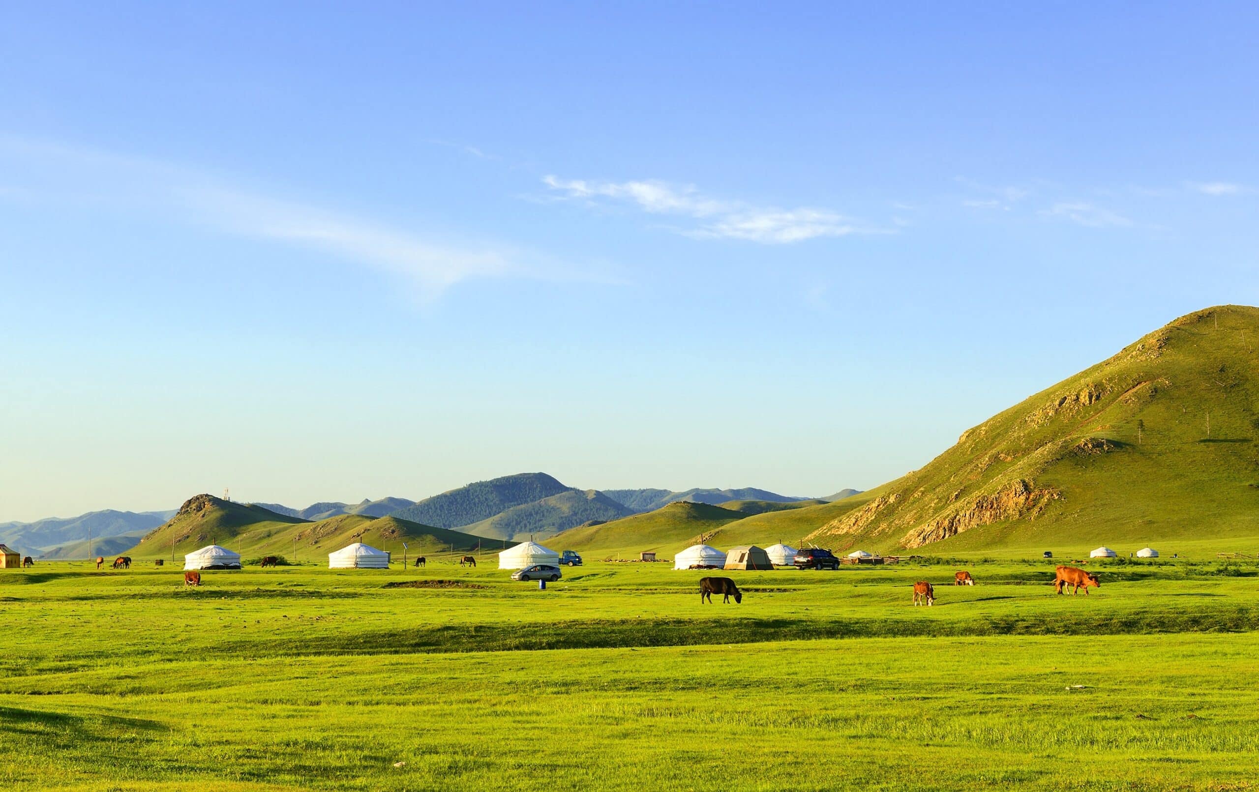
Mongolia is a vast, landlocked nation in East and Central Asia, bordered by Russia to the north and China to the south. Despite its relatively small population, it is one of the largest countries in the world by area, defined by immense open landscapes and dramatic continental extremes.
Geographically, Mongolia is dominated by steppe grasslands, deserts, and mountain ranges. The Altai Mountains rise in the west, with peaks exceeding 4,000 meters, while forested highlands and volcanic fields stretch across the north and center. In the south lies the Gobi Desert, a cold desert characterized by rocky plains, sand dunes, and sparse vegetation.
Much of Mongolia sits on a high plateau averaging around 1,500 meters above sea level. Rivers such as the Selenge flow northward into Lake Baikal in Russia, while inland basins and salt lakes punctuate arid regions. The country’s geology reflects ancient tectonic activity, with folded mountain belts, mineral-rich formations, and volcanic remnants shaped over hundreds of millions of years.
Mongolia experiences a harsh continental climate. Winters are long and intensely cold, with temperatures dropping below –30°C in many areas, while summers can be short but hot. Precipitation is generally low, especially in the desert south, making much of the landscape semi-arid.
The geography of Mongolia is defined by space and elevation — open horizons, sweeping grasslands, alpine peaks, and desert expanses. Settlement patterns remain sparse, with nomadic pastoralism historically shaped by climate and terrain.
In the chapters ahead, Mongolia will be explored through its capital, mountain systems, desert regions, lakes, and steppe ecosystems.
18. Ulaanbaatar
Ulaanbaatar lies in north-central Mongolia along the Tuul River, surrounded by forested mountains. Geography here is high-altitude river valley enclosed by upland terrain.
The city sits at approximately 1,350 meters above sea level within a basin formed by tectonic uplift and long-term erosion. Hills composed of granite and metamorphic rock encircle the valley, influencing airflow and seasonal temperature patterns.
The Tuul River, a tributary of the Selenge system, flows westward and ultimately drains toward Lake Baikal in Russia. Alluvial deposits along its banks created relatively stable ground for settlement.
Ulaanbaatar has one of the most extreme continental climates of any capital city. Winters are long and severely cold, often dropping below –30°C, while summers are short but warm. Low precipitation and clear skies characterize much of the year.
Geologically, the region reflects ancient tectonic collisions that formed the Central Asian Orogenic Belt. Mineral-rich formations surround the city.
Endurance here is climatic. Urban infrastructure must withstand severe cold, seasonal river freezing, and occasional dust storms.
Ulaanbaatar reflects Mongolia’s high plateau geography — elevated, river-centered, and enclosed by resilient uplands.
17. Gobi Desert
Gobi Desert spans southern Mongolia and northern China. Geography here is cold desert plateau rather than continuous sand dunes.
Unlike tropical deserts, the Gobi consists mainly of gravel plains, rocky outcrops, and sparse vegetation. Sand dunes exist in specific areas, but much of the terrain is bare stone and hard-packed earth.
The desert lies at elevations between 900 and 1,500 meters. It formed through rain-shadow effects from surrounding mountain ranges that block moisture-bearing winds.
The climate is extreme continental: summers can exceed 40°C, while winters plunge well below freezing. Strong winds contribute to dust storms and ongoing erosion.
Geologically, the Gobi contains sedimentary basins rich in fossils and minerals. Tectonic activity and ancient inland seas shaped parts of the landscape millions of years ago.
Endurance here is arid and wind-driven. Sparse vegetation and low rainfall limit soil development.
The Gobi Desert reflects Mongolia’s southern plateau geography — elevated, dry, and shaped by continental climate extremes.
16. Altai Mountains
Altai Mountains rise in western Mongolia near the borders with Russia and China. Geography here is high alpine terrain formed by tectonic uplift.
The range contains some of Mongolia’s highest peaks, including Khüiten Peak at over 4,300 meters. Glaciers persist at the highest elevations, feeding rivers that flow into inland basins.
The mountains consist primarily of metamorphic and igneous rock shaped by ancient continental collisions. Over time, glaciation carved valleys and sharp ridgelines.
The climate varies with altitude. Lower slopes experience steppe conditions, while higher elevations remain cold and snow-covered much of the year.
Geologically, the Altai are part of the Central Asian Orogenic Belt, reflecting complex plate interactions over hundreds of millions of years.
Endurance here is alpine and glacial. Freeze-thaw cycles and seasonal snowmelt shape valleys and slopes.
The Altai Mountains reflect western Mongolia’s uplifted geography — rugged, glaciated, and climatically stratified by elevation.
15. Lake Khövsgöl
Lake Khövsgöl lies in northern Mongolia near the Russian border, positioned within a tectonic basin associated with the Baikal Rift system. Geography here is alpine freshwater depression surrounded by taiga-covered mountains.
The lake sits at approximately 1,645 meters above sea level and reaches depths of over 260 meters, making it one of the deepest lakes in Central Asia. It formed through crustal stretching and subsidence linked to regional rifting processes. Over time, meltwater and mountain runoff filled the basin, creating a vast freshwater reservoir that holds a significant proportion of Mongolia’s surface freshwater.
The surrounding terrain consists largely of ancient crystalline rocks — granites and metamorphic formations shaped by long-term uplift and erosion. Forests of larch and pine dominate the slopes, marking a transition zone between Siberian taiga and Mongolian steppe ecosystems.
The climate is sharply continental. Winters are long and severe, with the lake surface freezing solid for several months. Ice thickness can exceed one meter. Summers are short and cool, with moderate precipitation feeding inflowing streams.
Hydrologically, the lake drains southward through the Egiin Gol River, which eventually connects to the Selenge River system flowing toward Lake Baikal.
Endurance here is tectonic and climatic. Freeze-thaw cycles shape shoreline rock, while seasonal snowmelt regulates water levels.
Lake Khövsgöl reflects northern Mongolia’s rift-valley geography — elevated, freshwater-rich, forest-bordered, and climatically extreme.
14. Orkhon Valley
Orkhon Valley stretches across central Mongolia along the Orkhon River, forming a broad fluvial corridor through steppe and volcanic terrain. Geography here is river-carved valley set within a high plateau.
The Orkhon River originates in the Khangai Mountains and flows northward, gradually carving a wide valley through layers of basalt and sedimentary rock. Ancient volcanic activity in central Mongolia produced lava flows that solidified into basalt plateaus, later dissected by river erosion.
Over thousands of years, alluvial deposits accumulated along the valley floor, creating fertile grasslands suitable for pastoral grazing. The surrounding hills remain gently rolling rather than sharply mountainous, reflecting prolonged erosion rather than recent tectonic uplift.
The region experiences a harsh continental climate, with cold winters and warm summers. Annual precipitation is relatively low, but summer rains support seasonal grass growth across the steppe.
Geologically, the valley illustrates interaction between volcanism and fluvial processes. Basalt cliffs and small waterfalls mark sections where resistant rock layers remain exposed.
Endurance here is fluvial. Seasonal flooding and snowmelt shape the riverbanks and replenish valley soils.
The Orkhon Valley reflects central Mongolia’s plateau-steppe geography — erosion-shaped, pasture-dominated, and historically structured by river systems cutting through ancient volcanic terrain.
13. Khongoryn Els
Khongoryn Els are towering sand dunes located within the southern Mongolian sector of the Gobi Desert. Geography here is aeolian dune system formed by sustained wind activity across an arid plateau.
The dunes extend roughly 100 kilometers in length and reach heights exceeding 300 meters in some sections. Unlike much of the Gobi, which consists primarily of gravel plains and rocky desert, Khongoryn Els represents a true sand accumulation zone.
The dunes formed from fine sediments eroded from surrounding mountain ranges and ancient lakebeds. Persistent winds transported and deposited these particles into linear ridges aligned with prevailing wind directions. Over time, the dunes grew through repeated deposition cycles.
The climate is extremely continental. Summer temperatures can exceed 40°C, while winter conditions drop well below freezing. Strong winds are frequent and continuously reshape dune crests, producing shifting slopes and sharp ridgelines.
Geologically, the underlying basin consists of sedimentary layers deposited over millions of years when parts of the region were influenced by inland seas and river systems. Today, aridity dominates.
Endurance here is wind-driven. Aeolian processes constantly redistribute sand, preventing stabilization except where limited vegetation anchors lower slopes.
Khongoryn Els reflects southern Mongolia’s desert plateau geography — elevated, wind-sculpted, climatically extreme, and continuously reshaped by atmospheric forces.
12. Terelj National Park
Gorkhi-Terelj National Park lies northeast of Ulaanbaatar in the Khentii Mountain range. Geography here is alpine-granite highland shaped by tectonic uplift and long-term weathering.
The park sits at elevations averaging around 1,600 meters above sea level. Its terrain consists largely of exposed granite bedrock that has fractured and eroded into rounded formations and dramatic rock outcrops. Freeze-thaw cycles play a major role in shaping these formations, widening cracks and gradually breaking apart exposed surfaces.
River systems, including tributaries of the Tuul River, cut through the landscape, creating narrow valleys bordered by forested slopes. Alluvial deposits accumulate along valley floors, supporting grassland meadows between rocky ridges.
The climate is sharply continental. Winters are long and severely cold, while summers are short and relatively mild. Precipitation is moderate compared to southern Mongolia, allowing mixed forest-steppe vegetation to develop.
Geologically, the region is part of the Central Asian Orogenic Belt, formed through ancient continental collisions. The resistant granite massifs reflect deep crustal processes that occurred hundreds of millions of years ago.
Endurance here is climatic and erosional. Seasonal temperature extremes and snowmelt influence slope stability and river flow.
Terelj reflects northeastern Mongolia’s mountain-steppe geography — uplifted, granite-dominated, and defined by seasonal climatic contrast.
11. Karakorum
Karakorum lies in central Mongolia within the Orkhon Valley. Geography here is steppe basin surrounded by low volcanic uplands.
Situated near the Orkhon River, the area developed on gently sloping terrain shaped by fluvial erosion and sediment deposition. The valley floor consists of alluvial soils accumulated over thousands of years.
Surrounding hills reveal basalt formations from ancient volcanic eruptions that once covered parts of central Mongolia with lava flows. Over time, erosion dissected these plateaus into rolling uplands.
The climate is strongly continental, with severe winters and warm summers. Precipitation remains limited but sufficient to sustain grasslands used for pastoral activity.
Geologically, the region illustrates the interaction of volcanism and river processes. Resistant basalt layers contrast with softer sedimentary deposits in valley floors.
Endurance here is fluvial and climatic. Snowmelt and seasonal rainfall regulate river discharge and soil moisture.
Karakorum reflects central Mongolia’s high plateau geography — river-fed, volcanic-influenced, and defined by open steppe expanses.
10. Uvs Lake
Uvs Lake lies in northwestern Mongolia within a large inland basin near the Russian border. Geography here is endorheic depression surrounded by desert-steppe and mountain ranges.
Uvs Lake sits at approximately 759 meters above sea level and has no outlet to the ocean. Rivers and streams flow into the basin, but water leaves only through evaporation, resulting in saline conditions.
The surrounding terrain includes the Tannu-Ola and Altai mountain systems, composed primarily of ancient metamorphic and igneous rock. These mountains supply runoff that sustains seasonal wetlands near the lake’s margins.
The climate is among the most extreme in Mongolia. Summers can be hot and dry, while winters are intensely cold, reflecting the region’s continental isolation.
Geologically, the basin formed through tectonic subsidence combined with long-term erosion. Sediments carried by inflowing rivers accumulate along the lake’s perimeter.
Endurance here is hydrological and climatic. Fluctuating water levels respond to evaporation rates and seasonal inflow.
Uvs Lake reflects western Mongolia’s basin geography — landlocked, saline, and shaped by the balance between runoff and evaporation under continental climate extremes.
9. Khangai Mountains
Khangai Mountains occupy central Mongolia, forming a broad upland massif between the Gobi Desert to the south and forested northern regions. Geography here is ancient uplifted plateau shaped by erosion and past volcanic activity.
The Khangai range averages between 2,000 and 3,000 meters in elevation, though its peaks are generally rounded rather than sharply jagged. This reflects prolonged weathering over millions of years rather than recent tectonic uplift. The mountains consist largely of granitic and metamorphic rock intruded by volcanic formations from earlier geological periods.
Numerous rivers originate in the Khangai highlands, including tributaries of the Orkhon and Selenge systems. Snowmelt and seasonal rainfall feed these rivers, making the region a hydrological core of Mongolia.
The climate is continental but slightly more moderate than the Gobi due to higher precipitation levels. Winters remain severe, while summers are short and cool. Forest-steppe vegetation dominates slopes, transitioning to alpine meadows at higher elevations.
Geologically, the Khangai represent part of the Central Asian Orogenic Belt, formed by ancient continental collisions. Subsequent erosion smoothed the terrain into rolling uplands.
Endurance here is climatic and fluvial. Seasonal freeze-thaw cycles and river incision continue to shape valleys and slopes.
The Khangai Mountains reflect central Mongolia’s elevated heartland — water-generating, erosion-rounded, and climatically transitional between desert and taiga zones.
8. Flaming Cliffs
Bayanzag, commonly known as the Flaming Cliffs, lie in the southern Gobi Desert. Geography here is sedimentary badlands shaped by wind and erosion.
The cliffs are composed primarily of red sandstone and siltstone deposited during the Late Cretaceous period, when the region supported river systems and semi-arid floodplains. Over millions of years, wind and water erosion sculpted the soft sedimentary layers into steep ridges and gullies.
The vivid red coloration becomes especially pronounced at sunset, when low-angle sunlight intensifies the iron-rich rock tones. The terrain consists of eroded escarpments rising abruptly from relatively flat desert plains.
The climate is extremely continental and arid. Rainfall is minimal, while temperature variation between summer and winter is dramatic. Wind erosion remains a dominant shaping force.
Geologically, the site is globally significant for fossil discoveries, including dinosaur eggs and skeletal remains embedded within the sedimentary layers. These fossils indicate that the area once supported diverse prehistoric ecosystems.
Endurance here is aeolian and erosional. Ongoing wind abrasion continues to reshape cliff faces and transport fine sediment.
The Flaming Cliffs reflect southern Mongolia’s badlands geography — arid, sedimentary, wind-carved, and colored by iron-rich strata exposed under desert skies.
7. Khar Nuur
Khar Nuur lies in western Mongolia within a series of interconnected inland basins. Geography here is semi-arid lake system bordered by desert-steppe and mountain foothills.
Unlike saline Uvs Lake to the north, Khar Nuur contains freshwater fed by mountain runoff and seasonal rivers descending from the Altai range. The lake sits within a shallow tectonic depression shaped by subsidence and sediment accumulation.
Surrounding terrain consists of gravel plains and low ridges composed of ancient crystalline rock. River inflow brings sediment that forms small deltas along parts of the shoreline.
The climate is sharply continental. Summers are warm and dry, while winters are long and extremely cold. Evaporation rates are high during warmer months, influencing seasonal water levels.
Geologically, the basin reflects tectonic fragmentation of western Mongolia’s crust, combined with erosion from adjacent highlands. Sedimentary deposits accumulate gradually along the lake margins.
Endurance here is hydrological. The balance between inflow and evaporation determines lake size and salinity stability.
Khar Nuur reflects western Mongolia’s basin-steppe geography — inland, runoff-fed, and shaped by the interplay between mountain water sources and arid plateau climate.
6. Khustain Nuruu National Park
Khustain Nuruu National Park lies west of Ulaanbaatar within central Mongolia’s forest-steppe transition zone. Geography here is rolling upland steppe bordered by low mountains shaped by ancient tectonic uplift.
The park occupies elevations between roughly 1,100 and 1,800 meters above sea level. Its terrain consists of gently rounded ridges composed primarily of granitic and metamorphic rock formed during the Paleozoic era. Long-term erosion has softened the landscape into broad valleys and sloping hills.
Seasonal streams flow through the park, feeding into the Tuul River basin. Alluvial deposits accumulate along valley floors, supporting grasses and scattered forest patches. The region marks a transitional ecological belt between open steppe and northern taiga influences.
The climate is sharply continental. Winters are long and severely cold, while summers are short and moderately warm. Annual precipitation is higher than in the Gobi but still limited, falling mostly during summer months.
Geologically, Khustain Nuruu reflects the structural complexity of the Central Asian Orogenic Belt. Ancient continental collisions uplifted the bedrock, later reshaped by weathering and erosion.
Endurance here is climatic and erosional. Freeze-thaw cycles influence soil stability, while seasonal rainfall regulates vegetation growth.
Khustain Nuruu reflects central Mongolia’s transitional geography — upland steppe, forest-edged, and shaped by ancient crustal formation processes.
5. Tsagaan Suvarga
Tsagaan Suvarga is a striking escarpment located in the Middle Gobi region of southern Mongolia. Geography here is sedimentary cliff system shaped by erosion of ancient seabed deposits.
The formation rises abruptly from relatively flat desert terrain, resembling the remains of a massive white city wall. It consists primarily of limestone and clay sediments deposited millions of years ago when the region lay beneath shallow inland seas.
Over time, tectonic uplift exposed these sedimentary layers. Wind and water erosion carved the cliff face into vertical ridges and gullies, revealing bands of white, pink, and rust-colored rock.
The climate is arid and strongly continental. Precipitation is low, and temperature extremes between summer and winter are significant. Wind erosion remains a dominant shaping force in the area.
Geologically, Tsagaan Suvarga illustrates Mongolia’s marine past. Fossilized marine organisms have been discovered within some limestone layers, confirming ancient seabed origins.
Endurance here is erosional and wind-driven. The soft sedimentary rock continues to weather under desert conditions.
Tsagaan Suvarga reflects southern Mongolia’s uplifted seabed geography — marine-born, desert-exposed, and gradually sculpted by wind and time.
4. Ikh Nart Nature Reserve
Ikh Nart Nature Reserve lies in southeastern Mongolia along the transition between steppe and semi-desert. Geography here is rocky outcrop landscape rising from dry grassland plains.
The reserve is characterized by dramatic granite formations and isolated rocky ridges that stand above surrounding flat terrain. These formations result from ancient crystalline bedrock exposed through long-term erosion of overlying sediments.
Seasonal streams cut shallow channels through the steppe, though water flow is irregular due to limited rainfall. Alluvial soils develop in depressions where moisture collects.
The climate is semi-arid and continental. Summers are hot and dry, while winters are cold and windy. Precipitation is sparse and highly seasonal.
Geologically, the region consists mainly of Precambrian granitic rock, part of Mongolia’s ancient crustal foundation. Weathering processes have produced fractured rock faces and talus slopes at the base of outcrops.
Endurance here is climatic and erosional. Wind abrasion and temperature fluctuations gradually shape exposed stone.
Ikh Nart reflects southeastern Mongolia’s rocky-steppe geography — crystalline bedrock exposed under arid skies and shaped by long-term continental weathering.
3. Buir Lake
Buir Lake lies in eastern Mongolia near the border with China. Geography here is lowland freshwater basin situated within expansive steppe plains.
The lake rests at approximately 583 meters above sea level, making it one of Mongolia’s lower-elevation water bodies. It forms part of a hydrological system connected to the Khalkh River, which supplies most of its inflow. Unlike many western Mongolian lakes, Buir Lake contains freshwater due to continuous river input and partial outflow.
The surrounding terrain consists of flat grassland underlain by sedimentary deposits accumulated through long-term fluvial processes. Seasonal flooding spreads nutrient-rich sediments across the plains, supporting steppe vegetation.
The climate is strongly continental. Winters are long and cold, while summers are warm and relatively wetter compared to western desert regions. Wind exposure across the open plains influences wave activity and shoreline erosion.
Geologically, the basin developed through tectonic subsidence combined with sediment accumulation from river systems. The shallow lake floor consists largely of fine-grained deposits.
Endurance here is hydrological and climatic. Water levels fluctuate depending on precipitation and river discharge.
Buir Lake reflects eastern Mongolia’s steppe-basin geography — low-lying, river-fed, and shaped by sediment transport across vast grassland plains.
2. Otgon Tenger
Otgon Tenger is the highest peak of the Khangai Mountains in central Mongolia. Geography here is alpine summit rising from an ancient volcanic massif.
The mountain reaches approximately 4,008 meters above sea level. Unlike the rounded uplands typical of the Khangai range, Otgon Tenger features steeper slopes and glacial remnants near its summit.
The peak consists primarily of granite intrusions formed deep within the Earth’s crust, later exposed through uplift and erosion. Small glaciers and permanent snowfields persist at higher elevations, feeding seasonal meltwater streams.
The climate varies sharply with altitude. Lower slopes experience forest-steppe conditions, while upper elevations remain cold and snow-covered for much of the year. Strong winds are common near the summit.
Geologically, Otgon Tenger reflects both tectonic uplift and ancient volcanic activity that shaped central Mongolia’s highlands. Freeze-thaw processes continue to fracture exposed rock faces.
Endurance here is alpine and glacial. Snow accumulation and melt influence downstream hydrology.
Otgon Tenger reflects Mongolia’s elevated heartland geography — high, granite-formed, and climatically stratified by altitude.
1. Great Gobi B Strictly Protected Area
Great Gobi B Strictly Protected Area occupies a vast expanse of southwestern Mongolia near the Chinese border. Geography here is desert basin enclosed by rugged mountain ranges.
The protected area lies within the Dzungarian Gobi, characterized by gravel plains, rocky ridges, and isolated mountain systems. Elevations vary widely, from low desert basins to peaks exceeding 2,000 meters.
The terrain consists largely of sedimentary rock and ancient crystalline formations exposed through erosion. Wind abrasion dominates surface shaping, producing desert pavements and sparse sand accumulations.
The climate is among the harshest in Mongolia. Summers are extremely hot, while winters are intensely cold. Precipitation is minimal and irregular.
Geologically, the region reflects tectonic fragmentation associated with Central Asian plate movements. Sedimentary basins alternate with uplifted mountain blocks.
Endurance here is arid and wind-driven. Limited vegetation and high evaporation rates define ecological conditions.
The Great Gobi B region reflects southwestern Mongolia’s extreme continental desert geography — expansive, tectonically varied, and shaped by climatic severity.