
Ecuador is a country defined by extraordinary geographic compression. Within a territory smaller than many U.S. states, it contains Pacific coastlines, Andean highlands, Amazon rainforest, and the Galápagos archipelago. This vertical and horizontal diversity shapes every aspect of life, from climate and agriculture to culture and settlement patterns.
The Andes divide Ecuador into distinct regions, creating dramatic elevation changes over short distances. Temperature is governed primarily by altitude rather than latitude, allowing tropical heat, temperate valleys, and alpine conditions to coexist. Rivers descend rapidly from the mountains, feeding fertile valleys and sustaining agriculture and urban centers. These same rivers also link the Andes to the Amazon basin, integrating ecological systems across regions.
Along the coast, warm currents, mangroves, and fertile plains support fishing, agriculture, and trade, while the Pacific influences weather patterns and economic activity. To the east, the Amazon rainforest dominates, harboring immense biodiversity and Indigenous cultures whose livelihoods remain closely tied to the land and rivers.
Ecuador’s geography has historically shaped Indigenous civilizations, colonial settlement, and modern development. Cities tend to cluster in valleys or along coasts, while remote highlands and rainforest areas preserve traditional ways of life. The result is a nation where environmental variation underpins cultural diversity and regional identity.
Understanding Ecuador requires viewing it not as a single landscape, but as an interconnected system of contrasting environments. This guide explores the country region by region, highlighting how geography defines daily life, economic systems, and cultural continuity across one of South America’s most diverse nations.
18. Quito and the Inter-Andean Corridor
Quito sits high in Ecuador’s northern Andes at approximately 2,850 meters above sea level, occupying a long and narrow basin within the Inter-Andean Corridor. The city is framed by steep ridges and active and dormant volcanoes, which shape both its dramatic scenery and its spatial development. Because of its elevation, Quito experiences cool, spring-like temperatures throughout the year, with minimal seasonal variation and frequent cloud cover drifting across surrounding peaks.
The fertile volcanic soils of the valley have supported human settlement for thousands of years. Indigenous societies cultivated maize, potatoes, and quinoa on terraced slopes long before Spanish colonization. Today, peri-urban agriculture continues in surrounding valleys, supplying vegetables and grains to the city. Rivers descending from nearby mountains provide water but also create challenges related to flooding, erosion, and landslide risk.
Urban growth in Quito is strongly linear, extending north and south along the valley floor while being constrained east and west by steep terrain. This geography has shaped transportation corridors, land use patterns, and population density. Modern infrastructure must adapt to seismic activity, limited space, and environmental protection of nearby slopes and watersheds.
As Ecuador’s political and cultural capital, Quito combines colonial heritage with modern institutions, universities, and industries. Its historic center, preserved within the valley’s confines, reflects the deep connection between geography and cultural continuity.
Quito exemplifies Andean urban adaptation, where elevation, geology, and climate dictate city form, economic activity, and daily life within one of South America’s most distinctive highland capitals.
17. Northern Highlands and Otavalo
The northern highlands of Ecuador, centered around Otavalo, are characterized by rolling hills, fertile intermontane valleys, and temperate climates moderated by altitude. Elevations typically range between 2,000 and 2,800 meters, creating ideal conditions for agriculture and long-established Indigenous settlement. Volcanic soils enrich the land, supporting diverse crops and pasture.
Otavalo and surrounding communities are renowned for their strong Indigenous identity, visible in traditional clothing, markets, and agricultural practices. Maize, beans, potatoes, and quinoa are cultivated on small plots, often irrigated by mountain streams and managed communally. Livestock grazing occurs on higher slopes, complementing crop production in valley floors.
Settlement patterns are compact and rural, with towns centered around plazas, markets, and communal lands. Weekly markets function as economic and social hubs, linking highland farmers with regional trade networks. Handwoven textiles form a significant economic activity, deeply tied to cultural continuity and landscape-based livelihoods.
Environmental stewardship remains essential, as erosion, water management, and climate variability affect agricultural productivity. Traditional knowledge, including crop rotation and terracing, continues to play a role in sustainable land use.
The northern highlands illustrate the enduring relationship between Andean geography and Indigenous culture, where fertile valleys, moderate climates, and community-based land management sustain one of Ecuador’s most distinctive regional identities.
16. Avenue of the Volcanoes
The Avenue of the Volcanoes stretches southward from Quito through Ecuador’s central Andes, forming one of the country’s most iconic landscapes. Towering volcanic peaks rise above broad high-altitude plains and fertile basins, creating a dramatic corridor shaped by tectonic activity. Elevations vary widely, producing sharp climatic contrasts over short distances.
Volcanic soils along the corridor are exceptionally fertile, supporting agriculture in sheltered valleys. Potatoes, grains, and vegetables are cultivated at higher elevations, while livestock graze on expansive páramo grasslands. Rivers originating from glaciers and snowmelt provide essential water resources but also pose risks through flooding and lahars during periods of volcanic activity.
Human settlement is concentrated in valleys and basins where terrain allows farming and infrastructure development. Towns and transport routes follow natural corridors between mountains, reflecting the influence of topography on mobility and trade. The region has long served as a north–south spine for economic and cultural exchange.
Seismic and volcanic hazards are an ever-present concern, requiring land-use planning, monitoring, and disaster preparedness. National parks protect fragile high-altitude ecosystems that regulate water supplies for downstream communities.
The Avenue of the Volcanoes exemplifies Ecuador’s geological dynamism, where active earth processes directly shape landscapes, livelihoods, and settlement patterns, highlighting the intimate link between natural forces and human adaptation in the Andes.
15. Cotopaxi Region
The Cotopaxi region is dominated by the near-perfect cone of Cotopaxi volcano, one of the highest active volcanoes in the world. Rising above vast high-altitude plains, the region sits mostly above 3,000 meters and is characterized by cold temperatures, strong winds, and expansive páramo grasslands. These grasslands play a crucial role in water regulation for central Ecuador.
Agriculture is adapted to extreme elevation. Lower slopes support hardy crops such as potatoes, barley, and legumes, while higher areas are used primarily for grazing cattle, sheep, and llamas. Volcanic soils enhance fertility, but frost and ashfall present ongoing challenges for farmers.
The Cotopaxi National Park protects fragile ecosystems, glaciers, and headwaters of major rivers. These water sources supply irrigation, drinking water, and hydroelectric power to densely populated regions downstream. Conservation efforts balance tourism, livestock use, and ecosystem preservation.
Settlement is sparse, with small communities and haciendas scattered across the plains. Roads and infrastructure must account for seismic risk and harsh weather conditions.
The Cotopaxi region illustrates the relationship between high-altitude ecology, volcanic activity, and human resilience, demonstrating how communities adapt livelihoods to one of Ecuador’s most extreme yet vital landscapes.
14. Tungurahua and Baños
The Tungurahua region centers on the active Tungurahua volcano and the town of Baños, located at the eastern edge of the Andes where mountains descend toward the Amazon basin. This transitional zone features steep slopes, deep valleys, and abundant water resources fed by rainfall and glacial runoff.
Baños benefits from a warm, humid climate compared to higher Andean regions, allowing cultivation of fruits, sugarcane, and coffee alongside traditional highland crops. Volcanic soils enhance fertility, while waterfalls and thermal springs support a thriving tourism economy. Agriculture, small-scale industry, and eco-tourism coexist within a compact landscape.
Volcanic activity has periodically disrupted settlement and farming, requiring evacuation plans and land-use restrictions. Despite these risks, communities remain resilient, adapting infrastructure and livelihoods to an active geological environment.
Rivers descending from Tungurahua supply hydroelectric power and irrigation, linking the region economically to both the highlands and the Amazon lowlands. Transportation routes follow river valleys, reinforcing Baños’ role as a gateway between regions.
The Tungurahua and Baños area exemplifies Ecuador’s ecological transition zones, where volcanic energy, water abundance, and human ingenuity converge to shape a dynamic and resilient regional landscape.
13. Central Highlands and Riobamba
The central highlands of Ecuador are defined by broad intermontane basins and high-altitude plains, with Riobamba positioned at approximately 2,750 meters above sea level. Surrounded by major volcanic peaks, including Chimborazo, the region experiences cool temperatures, intense sunlight, and strong winds. These environmental conditions shape both agriculture and settlement patterns.
Riobamba lies within a fertile basin formed by volcanic activity, producing soils well suited for crops such as potatoes, barley, wheat, and legumes. Livestock farming, particularly sheep and cattle, complements crop cultivation on surrounding grasslands. Traditional farming techniques, including crop rotation and terracing, remain common in rural communities.
The city serves as a regional transportation and commercial hub, linking northern and southern highlands as well as routes toward the coastal and Amazonian lowlands. Roads and rail corridors follow natural valleys, reflecting the influence of topography on mobility and trade. Markets in Riobamba distribute agricultural products across the region, reinforcing its economic role.
Environmental challenges include frost, soil erosion, and water scarcity during dry seasons. Rivers originating from nearby glaciers provide irrigation and drinking water but are vulnerable to climate change and glacial retreat.
The central highlands and Riobamba exemplify Ecuador’s high-altitude agricultural heartland, where volcanic geology, climate extremes, and human adaptation combine to sustain productive landscapes and resilient communities.
12. Chimborazo Region
The Chimborazo region is dominated by Mount Chimborazo, Ecuador’s highest peak and one of the most prominent mountains on Earth when measured from the planet’s center. Rising above expansive páramo grasslands, the region reaches elevations exceeding 6,000 meters, creating extreme alpine conditions and sparse vegetation.
At lower elevations, Indigenous communities practice pastoralism, grazing llamas, alpacas, sheep, and cattle on high-altitude grasslands. Limited crop cultivation occurs in sheltered valleys, focusing on hardy varieties such as potatoes and grains. Water sources originating from Chimborazo’s glaciers are vital, feeding rivers that supply agriculture and urban centers far beyond the region.
The Chimborazo Fauna Production Reserve protects fragile ecosystems and endemic species, including vicuñas and Andean birds. Conservation efforts aim to balance grazing, tourism, and ecosystem preservation. Climate change poses a significant threat, as glacial retreat affects water availability and ecosystem stability.
Settlement is sparse and adapted to harsh conditions, with scattered villages and long distances between communities. Infrastructure development is limited by terrain, cold temperatures, and seismic risk.
The Chimborazo region represents Ecuador’s extreme highlands, where altitude, climate, and geology impose strict limits on human activity while providing critical water resources and ecological value to the nation.
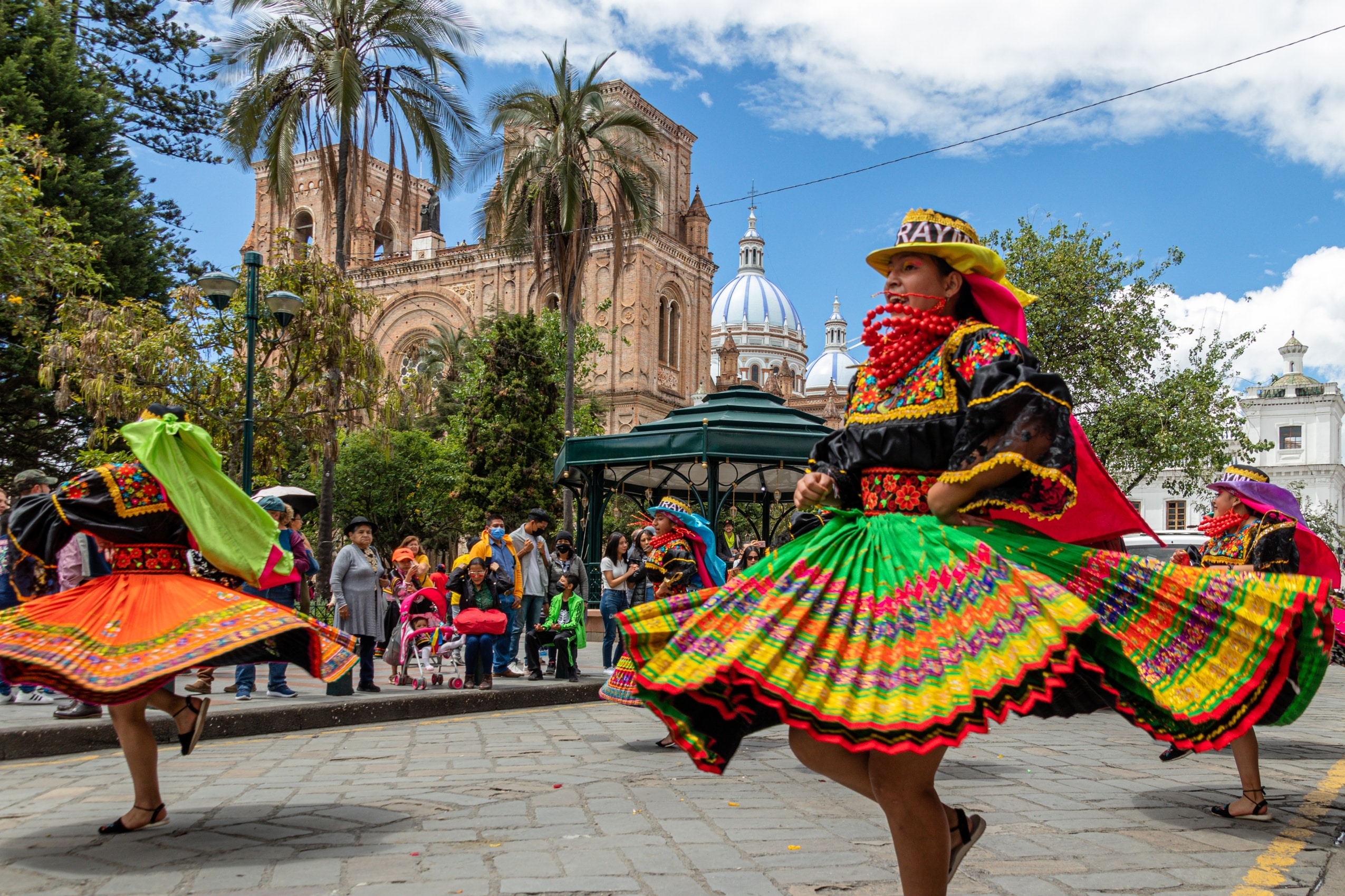
11. Southern Highlands – Cuenca
Cuenca is situated in Ecuador’s southern highlands at approximately 2,560 meters above sea level, occupying a broad basin intersected by four rivers. The city enjoys a mild, temperate climate and fertile alluvial soils that have supported continuous settlement since pre-Columbian times.
Agriculture in the surrounding region includes maize, potatoes, grains, and vegetables, cultivated on terraced slopes and valley floors. Livestock farming complements crop production, while irrigation systems channel river water to fields throughout the basin. The rivers also provide drinking water and contribute to flood regulation.
Cuenca functions as a cultural and administrative center, renowned for its historic architecture, artisan traditions, and educational institutions. Urban development balances preservation with modernization, guided by the basin’s geography and hydrology.
Transportation routes connect Cuenca with coastal lowlands and Amazonian foothills, reinforcing its role as a regional hub. Environmental management focuses on watershed protection, waste treatment, and sustainable urban growth.
The southern highlands and Cuenca illustrate Ecuador’s Andean balance between fertile landscapes, cultural continuity, and environmentally conscious urban development.
10. Loja Highlands
The Loja highlands occupy Ecuador’s southernmost Andean region, characterized by rolling hills, intermontane valleys, and a comparatively drier climate than much of the central Andes. Elevations range from 1,800 to 2,500 meters, producing temperate conditions suited to diverse agricultural activities.
Coffee cultivation is a defining feature, thriving on mid-altitude slopes with moderate rainfall. Maize, beans, sugarcane, and fruit trees are grown in valleys, while cattle grazing occurs on higher ground. The region’s relative isolation has preserved traditional farming practices and distinct cultural expressions.
Settlement patterns are dispersed, with small towns and rural communities connected by winding mountain roads. Loja serves as a regional center for education, music, and commerce, maintaining strong cultural traditions shaped by geographic isolation.
Environmental challenges include water scarcity during dry seasons and soil erosion on slopes. Sustainable land management practices, such as agroforestry and terracing, are increasingly emphasized.
The Loja highlands exemplify Ecuador’s southern Andean landscapes, where moderate climates, agricultural diversity, and cultural individuality define a distinctive regional identity.
9. Pacific Coastal Lowlands
Ecuador’s Pacific coastal lowlands extend along the western edge of the country, characterized by flat plains, river deltas, mangroves, and estuaries. The region experiences warm tropical temperatures and seasonal rainfall influenced by ocean currents and atmospheric patterns.
Agriculture dominates the landscape, with bananas, cacao, rice, and oil palm cultivated on fertile alluvial soils. Large river systems provide irrigation and transport, linking rural production zones with coastal ports. Aquaculture and fishing contribute significantly to the regional economy.
Human settlement is concentrated in low-lying towns and agricultural centers, often vulnerable to flooding during heavy rains or El Niño events. Infrastructure development prioritizes drainage, flood control, and coastal protection.
Mangrove ecosystems play a crucial role in coastal stability, fisheries, and biodiversity. Conservation efforts aim to protect these habitats while supporting local livelihoods.
The Pacific coastal lowlands demonstrate Ecuador’s tropical agricultural engine, where fertile soils, river systems, and coastal ecosystems sustain economic productivity while requiring careful environmental management.
8. Guayaquil and the Guayas Basin
Guayaquil is Ecuador’s largest city and principal port, located within the expansive Guayas River basin along the Pacific lowlands. The basin is one of the most fertile and economically significant regions in the country, shaped by broad floodplains, tidal rivers, and tropical climatic conditions. Temperatures remain warm year-round, with pronounced wet and dry seasons influencing agriculture and urban life.
The Guayas River and its tributaries form an extensive network that supports irrigation, transportation, and fisheries. Fertile alluvial soils enable large-scale cultivation of bananas, rice, cacao, sugarcane, and tropical fruits, making the basin a cornerstone of Ecuador’s export economy. Aquaculture, particularly shrimp farming, is also widespread in coastal and estuarine zones.
Guayaquil developed as a strategic trading hub due to its navigable waterways and proximity to the Pacific Ocean. Urban expansion has followed riverbanks and reclaimed lowlands, requiring extensive flood control, drainage systems, and levees. Seasonal flooding and rising sea levels pose ongoing challenges for infrastructure and public health.
Mangroves and wetlands surrounding the city provide natural flood mitigation and biodiversity habitats but face pressure from urbanization and industrial development. Conservation initiatives increasingly emphasize restoration and sustainable resource management.
Guayaquil and the Guayas basin illustrate the dynamic interaction between tropical river systems, economic productivity, and urban growth, highlighting the opportunities and vulnerabilities of Ecuador’s coastal heartland.
7. Manabí Coast
The Manabí coast stretches along Ecuador’s central Pacific shoreline, characterized by sandy beaches, rocky headlands, dry tropical forests, and fertile coastal plains. Unlike the wetter southern coast, Manabí experiences a semi-arid climate with pronounced dry seasons, shaped by ocean currents and regional wind patterns.
Agriculture in Manabí is adapted to limited rainfall, relying on seasonal rivers and reservoirs. Maize, peanuts, coffee, and cacao are cultivated alongside fruit trees and subsistence crops. Fishing and small-scale aquaculture support coastal communities, while artisanal practices remain culturally significant.
Settlement patterns are dispersed, with small towns and fishing villages spread along the coast and interior valleys. Infrastructure development must account for water scarcity, soil erosion, and vulnerability to seismic activity, as the region lies near major tectonic boundaries.
The coastline is ecologically diverse, supporting marine life, seabirds, and mangrove ecosystems in sheltered bays. Tourism has grown steadily, centered on beaches, surf culture, and nature reserves, contributing to economic diversification.
The Manabí coast reflects Ecuador’s climatic and ecological diversity, where dry coastal environments foster resilient agricultural systems, maritime traditions, and distinctive cultural identities shaped by land and sea.
6. Esmeraldas Province
Esmeraldas Province occupies Ecuador’s northern Pacific coast and is one of the country’s most biologically rich regions. Dense tropical rainforests, mangrove-lined estuaries, and high rainfall define the landscape, creating lush environments shaped by river systems flowing from the western Andes.
Agriculture focuses on cacao, bananas, oil palm, and subsistence crops grown on fertile but erosion-prone soils. Rivers serve as vital transportation routes, linking remote communities to coastal ports and markets. Fishing and forestry also contribute to local livelihoods.
Settlement is concentrated along rivers and the coast, with communities adapted to humid conditions and frequent flooding. Infrastructure challenges include road maintenance, water management, and access to services in remote rainforest areas.
Esmeraldas is culturally distinctive, with strong Afro-Ecuadorian heritage expressed through music, cuisine, and social traditions. This cultural landscape is deeply connected to the region’s geography and historical isolation.
Environmental conservation is critical, as deforestation, mining, and agricultural expansion threaten ecosystems. Protected areas aim to preserve biodiversity while supporting sustainable development.
Esmeraldas Province exemplifies Ecuador’s tropical rainforest coast, where ecological abundance, cultural richness, and environmental vulnerability coexist.
5. Amazonian Foothills
Ecuador’s Amazonian foothills form a transitional zone between the Andes and the Amazon basin, marked by steep slopes, dense forests, and high rainfall. Elevations decrease rapidly from mountain ridges into lowland rainforests, creating diverse microclimates and ecosystems.
Rivers originating in the Andes cut through the foothills, supplying water, nutrients, and transportation routes. These waterways support subsistence agriculture, fishing, and small-scale commerce in Indigenous and rural communities. Crops such as plantains, cassava, cacao, and fruits thrive in humid conditions.
Settlement is dispersed and often closely tied to river systems, as dense forests and rugged terrain limit road construction. Infrastructure development must balance accessibility with environmental protection, as landslides and flooding are common.
The foothills are biologically rich, hosting high levels of species diversity and endemism. They also serve as buffers protecting Amazonian lowlands from upstream environmental impacts.
The Amazonian foothills highlight Ecuador’s ecological gradients, where Andean geology transitions into rainforest systems, shaping livelihoods, biodiversity, and land-use challenges.
4. Amazon Basin – Upper Oriente
The Upper Oriente encompasses Ecuador’s portion of the Amazon basin, characterized by lowland rainforests, winding rivers, and year-round high humidity. Elevations generally remain below 500 meters, with flat terrain punctuated by floodplains and oxbow lakes.
The region’s rivers are central to transportation, subsistence, and ecological processes. Indigenous communities rely on fishing, hunting, and shifting cultivation, growing crops such as cassava, maize, and plantains. Traditional knowledge guides sustainable use of forest resources.
Biodiversity in the Upper Oriente is among the highest globally, supporting complex ecosystems and countless species. Protected areas and Indigenous territories aim to safeguard habitats and cultural heritage.
Economic activity includes oil extraction and limited agriculture, creating tensions between development and environmental conservation. Pollution risks, deforestation, and infrastructure expansion pose significant challenges.
The Upper Oriente represents Ecuador’s Amazonian frontier, where global ecological importance, Indigenous stewardship, and development pressures intersect within one of the planet’s most sensitive environments.
3. Galápagos Islands
The Galápagos Islands lie approximately 1,000 kilometers west of mainland Ecuador and form one of the world’s most significant natural laboratories for evolutionary science. Volcanic in origin, the archipelago consists of rugged islands shaped by lava flows, shield volcanoes, and barren basaltic landscapes. Their isolation and varied microclimates have produced extraordinary levels of endemism.
The climate is influenced by ocean currents, resulting in relatively mild temperatures compared to equatorial norms. Nutrient-rich waters support abundant marine life, including fish, seabirds, marine iguanas, and sea lions. Terrestrial ecosystems range from arid lowlands with cactus forests to humid highland zones with mosses and endemic trees.
Human settlement is limited and carefully regulated. Small towns concentrate economic activity around tourism, conservation, and scientific research. Strict environmental controls govern land use, fishing, and visitor access to protect fragile ecosystems.
Tourism provides vital revenue but requires continuous management to minimize ecological impact. Conservation institutions and international cooperation play central roles in preserving biodiversity.
The Galápagos Islands exemplify Ecuador’s global environmental importance, where volcanic geology, oceanic systems, and conservation policy converge to protect one of Earth’s most unique ecological treasures.
2. Coastal Mangroves and Estuaries
Ecuador’s coastal mangroves and estuaries form complex ecosystems along sheltered bays and river mouths of the Pacific coast. These environments are shaped by tidal flows, sediment deposition, and brackish waters that support high biological productivity.
Mangroves serve as nurseries for fish and crustaceans, supporting local fisheries and coastal food security. They also stabilize shorelines, reduce erosion, and buffer communities from storm surges and flooding. Estuarine zones link inland river systems with marine environments, facilitating nutrient exchange.
Human use includes fishing, shellfish harvesting, and limited aquaculture. In some areas, mangroves have been cleared for shrimp farming, prompting conservation responses to restore degraded habitats.
Protected areas and community-led management initiatives aim to balance economic livelihoods with ecosystem preservation. Education and sustainable practices increasingly guide coastal development.
Ecuador’s mangroves and estuaries highlight the ecological and economic value of transitional coastal environments, emphasizing the need for integrated conservation strategies.
1. Cloud Forests of the Western Andes
The cloud forests of Ecuador’s western Andean slopes form one of the most biologically diverse ecosystems in the world. Persistent mist, high rainfall, and moderate temperatures create lush forests rich in epiphytes, orchids, and moss-covered trees.
These forests act as critical water regulators, capturing moisture from clouds and releasing it gradually into rivers supplying coastal and highland regions. Biodiversity is exceptionally high, with numerous endemic plant and animal species.
Human settlement is limited but expanding, often linked to agriculture, eco-tourism, and conservation initiatives. Shade-grown crops such as coffee and cacao coexist with forest preservation efforts.
Deforestation and land conversion pose ongoing threats, prompting the establishment of reserves and sustainable land-use programs.
The cloud forests represent Ecuador’s ecological bridge between Andes and coast, underscoring the importance of conservation in maintaining biodiversity and water security.