

South Korea occupies the southern half of the Korean Peninsula in East Asia, bordered by the Yellow Sea to the west, the East Sea (Sea of Japan) to the east, and the Korea Strait to the south. Though relatively compact in size, the country’s terrain is diverse — dominated by mountains, river valleys, and deeply indented coastlines.
Approximately 70% of South Korea is mountainous. The Taebaek Mountains run along the eastern side of the peninsula, creating a steep, narrow coastal strip facing the East Sea and broader plains toward the west. Rivers such as the Han, Nakdong, and Geum flow from upland regions toward western and southern lowlands, depositing fertile alluvial soils that support agriculture and urban development.
The peninsula sits near tectonic boundaries but is less seismically active than neighboring Japan. Most of South Korea’s landscape consists of ancient crystalline rock shaped by uplift and long-term erosion rather than active volcanism, though volcanic features are present on Jeju Island.
The climate is temperate with four distinct seasons. Winters are cold and dry under continental air masses from Siberia, while summers are hot and humid due to the East Asian monsoon. Late summer typhoons occasionally affect southern coastal areas.
South Korea’s geography reflects strong contrasts: rugged interior highlands, broad western river plains, intricate southern archipelagos, and dramatic eastern cliffs. The interaction between mountains and sea has shaped settlement patterns, transportation routes, and economic development.
In the chapters ahead, South Korea will be explored through its mountains, coastal cities, volcanic islands, river basins, and historic urban centers.
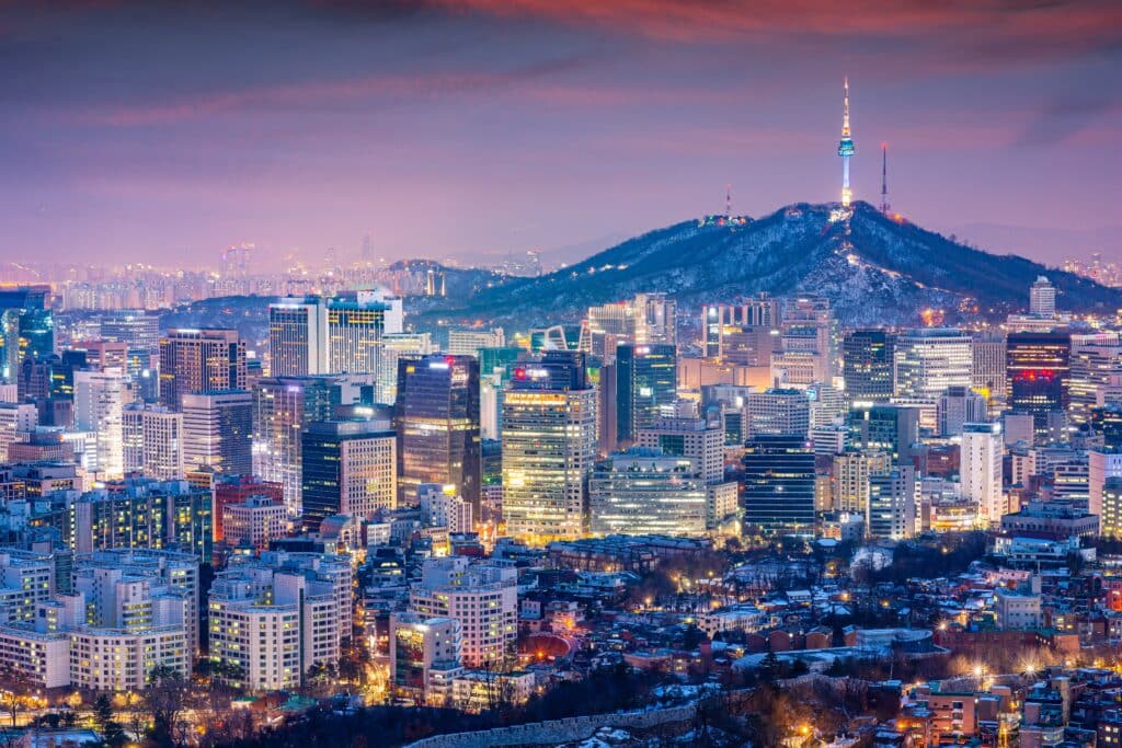
15. Seoul
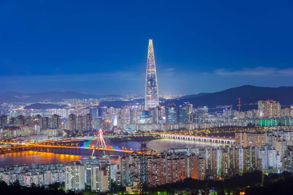
Seoul lies in the northwestern part of South Korea along the Han River. Geography here is river-basin terrain enclosed by low granite mountains.
The city developed within a broad valley carved by the Han River and its tributaries. Over centuries, sediment deposition created flat alluvial plains suitable for settlement and agriculture. Surrounding peaks such as Bukhansan and Namsan consist primarily of ancient granite uplifted and weathered over millions of years.
Seoul’s location near the Yellow Sea allowed maritime access while remaining inland enough for protection. The Han River continues westward into a tidal estuary, linking the city to coastal systems.
The climate is humid continental, influenced by monsoonal patterns. Summers are hot and rainy, while winters are cold and dry due to Siberian air masses. Seasonal rainfall plays a significant role in river flow and flood management.
Geologically, Seoul rests on Precambrian crystalline rock overlain by river sediments. Although the region is less seismically active than Japan, minor earthquakes occasionally occur.
Endurance here is fluvial and climatic. Flood-control systems along the Han River and slope stabilization in surrounding hills are essential for urban resilience.
Seoul reflects northwestern South Korea’s basin geography — river-centered, mountain-framed, and seasonally influenced by monsoon dynamics. Visitors encounter a city where granite peaks and broad waterways define both skyline and structure.
14. Busan
Busan sits on the southeastern coast along the Korea Strait. Geography here is mountainous coastline combined with deep natural harbors.
The city occupies narrow valleys and coastal flats between steep hills composed largely of granite and metamorphic rock. Rivers descending from inland highlands empty into the sea, forming small deltas and estuaries.
Busan’s port benefits from protected bays and proximity to major maritime routes linking East Asia. The coastline includes rocky headlands, sandy beaches, and reclaimed waterfront areas.
The climate is humid subtropical, milder than inland regions due to maritime influence. Typhoons occasionally impact the area during late summer.
Geologically, Busan rests on ancient crystalline rock shaped by long-term erosion. While tectonically stable compared to Japan, the broader peninsula remains influenced by distant plate interactions.
Endurance here is coastal and climatic. Harbor engineering and shoreline management are central to maintaining the city’s maritime role.
Busan reflects southeastern South Korea’s harbor geography — mountain-backed, sea-facing, and strategically positioned along international shipping lanes. Visitors encounter dramatic coastal contrasts between steep hills and open ocean.
13. Jeju Island
Jeju Island lies south of the Korean Peninsula in the Korea Strait. Geography here is volcanic island terrain dominated by a central shield volcano.
The island formed through repeated eruptions over millions of years. Basaltic lava flows created broad plateaus and gently sloping terrain radiating from Hallasan, South Korea’s highest peak.
Unlike mainland South Korea’s granite mountains, Jeju consists primarily of volcanic rock. Lava tubes, crater cones, and basalt cliffs define much of the landscape.
The coastline features rocky formations, sea cliffs, and small sandy beaches shaped by wave erosion and volcanic geology.
The climate is subtropical, warmer than mainland regions, with mild winters and humid summers. The island is occasionally affected by typhoons.
Geologically, Hallasan is considered dormant but remains monitored. The volcanic origin distinguishes Jeju from the largely non-volcanic mainland.
Endurance here is volcanic and marine. Coastal erosion and weather exposure continually reshape parts of the island.
Jeju Island reflects southern South Korea’s volcanic geography — basalt-built, ocean-surrounded, and climatically milder than the peninsula. Visitors encounter lava fields and crater landscapes that contrast sharply with mainland mountain systems.
12. Gyeongju
Gyeongju lies in southeastern South Korea within a broad inland basin near the East Sea. Geography here is valley-and-lowland terrain surrounded by gentle mountains.
The city developed on fertile plains formed by sediment from rivers descending out of the Taebaek mountain range. Over time, alluvial deposition created stable agricultural land within the basin.
Low mountains composed largely of granite and metamorphic rock enclose the region, shaping settlement patterns and transportation routes. The nearby coastline features rocky shores and small bays.
The climate is humid subtropical, with hot summers and relatively mild winters compared to northern regions. Seasonal monsoon rains influence river flow and agricultural cycles.
Geologically, the area rests on ancient crystalline rock weathered through long-term erosion. While South Korea is less tectonically active than Japan, minor seismic events occasionally occur.
Endurance here is fluvial and climatic. River management and seasonal rainfall adaptation remain central to land use.
Gyeongju reflects southeastern South Korea’s basin geography — sediment-built, mountain-framed, and seasonally influenced. Visitors encounter wide plains transitioning to soft uplands that illustrate the peninsula’s inland terrain.
11. Incheon
Incheon sits along the northwestern coast facing the Yellow Sea. Geography here is tidal mudflat coastline and low coastal plain shaped by strong tidal variation.
The Yellow Sea experiences some of the highest tidal ranges in East Asia. As a result, extensive mudflats form along Incheon’s shoreline, creating dynamic intertidal ecosystems.
The city developed on reclaimed land and riverine deposits from streams flowing toward the sea. Offshore islands dot the coastal waters, formed by uplifted and eroded rock.
The climate is humid continental, with cold winters influenced by Siberian air masses and warm, humid summers under monsoonal conditions.
Geologically, the region consists primarily of granite and metamorphic rock overlain by sedimentary deposits. Continuous tidal movement shapes coastal morphology.
Endurance here is tidal and coastal. Land reclamation, sea walls, and drainage systems are essential to managing fluctuating sea levels.
Incheon reflects northwestern South Korea’s mudflat geography — tide-dominated, sediment-rich, and sea-facing. Visitors encounter expansive tidal zones that contrast with the steeper eastern coastline of the peninsula.
10. Seoraksan National Park
Seoraksan National Park lies in northeastern South Korea along the Taebaek Mountain range. Geography here is rugged granite mountain terrain shaped by uplift and erosion.
The park’s peaks rise sharply above surrounding valleys, formed primarily from ancient granite that has resisted erosion. Over millions of years, weathering carved steep cliffs, narrow gorges, and rocky outcrops.
The Taebaek Mountains run parallel to the East Sea, creating a narrow coastal plain on the eastern side and broader interior valleys to the west.
The climate is temperate with significant seasonal variation. Winters bring snow to higher elevations, while summers are warm and influenced by monsoon rainfall.
Rivers originate in the mountains and flow toward both the East Sea and inland basins. Seasonal runoff contributes to ongoing landscape change.
Geologically, Seoraksan reflects long-term tectonic uplift followed by erosion rather than active volcanism. The granite composition distinguishes it from volcanic regions like Jeju.
Endurance here is climatic and erosional. Freeze-thaw cycles and heavy rainfall gradually reshape cliffs and slopes.
Seoraksan National Park reflects eastern South Korea’s mountain geography — granite-built, sharply elevated, and seasonally snow-covered. Visitors encounter dramatic peaks that highlight the peninsula’s rugged eastern spine.
9. Daegu
Daegu lies in southeastern South Korea within a broad inland basin surrounded by low mountain ranges. Geography here is enclosed valley terrain shaped by river systems and long-term erosion.
The city sits in the Nakdong River basin, where tributaries descending from surrounding hills deposit sediment across flat valley floors. This alluvial plain has historically supported agriculture and settlement.
Encircling mountains consist primarily of granite and metamorphic rock formed during ancient tectonic events. Over millions of years, weathering and erosion reduced once higher peaks into rounded uplands.
The basin topography influences Daegu’s climate. Summers are especially hot due to limited airflow and heat retention within the enclosed valley, while winters are comparatively dry and cool.
The broader region is tectonically stable relative to neighboring Japan, though minor seismic activity can occur due to distant plate interactions.
Geologically, Daegu rests on sedimentary deposits over crystalline bedrock. Seasonal monsoon rains influence river discharge and occasional flooding.
Endurance here is fluvial and climatic. Drainage systems and heat adaptation are central to urban planning.
Daegu reflects inland South Korea’s basin geography — river-formed, mountain-enclosed, and seasonally intense in temperature variation. Visitors encounter wide valley landscapes framed by gently rising ridgelines.
8. Daejeon
Daejeon is located in central South Korea where several river valleys converge. Geography here is transitional terrain between western plains and eastern mountains.
The city developed along the Geum River basin, where sediment deposition created pockets of fertile lowland amid rolling hills. Surrounding terrain consists largely of ancient granite and metamorphic rock uplifted through tectonic processes.
Daejeon’s central position places it at a crossroads of inland transportation corridors that follow river valleys through mountainous terrain.
The climate is humid continental, with hot summers influenced by monsoon rainfall and cold winters under continental air masses.
Geologically, the region reflects long-term uplift and erosion rather than active volcanism. River incision continues to shape valleys and slopes.
Endurance here is fluvial. Seasonal rains require effective watershed management to control runoff and maintain river stability.
Daejeon reflects central South Korea’s transition geography — valley-linked, moderately elevated, and structurally defined by ancient rock formations. Visitors encounter rolling terrain that connects coastal plains with interior highlands.
7. Gangneung
Gangneung lies on the eastern coast along the East Sea. Geography here is narrow coastal plain bordered immediately by the Taebaek Mountains.
The mountains rise steeply west of the city, composed primarily of granite and metamorphic rock. Rivers descend quickly from upland slopes, forming short valleys before reaching the sea.
The coastline features sandy beaches, rocky headlands, and shallow bays shaped by wave action and sediment transport. Unlike the tidal mudflats of the Yellow Sea, the East Sea coastline experiences lower tidal variation.
The climate is temperate with maritime influence. Winters can bring snowfall from cold air masses crossing the East Sea, while summers are warm and humid.
Geologically, the eastern mountain range reflects ancient uplift and erosion. The steep gradient between mountains and sea creates dramatic elevation change over short distances.
Endurance here is coastal and climatic. Storm surges and winter weather patterns influence shoreline stability.
Gangneung reflects eastern South Korea’s mountain-to-sea geography — steep, compact, and directly ocean-facing. Visitors encounter a striking contrast between granite ridges and open shoreline, illustrating the peninsula’s narrow eastern coastal belt.
6. Suwon
Suwon lies just south of Seoul within the greater Han River basin. Geography here is lowland plain transitioning into rolling hills.
The city developed on alluvial land formed by tributaries of the Han River. Over centuries, sediment deposition created fertile agricultural plains that later supported urban expansion.
Surrounding terrain consists of modest granite hills shaped by long-term erosion of ancient crystalline rock. Unlike the steeper Taebaek Mountains to the east, this region features gentler elevation changes.
The climate is humid continental, similar to Seoul, with hot, monsoon-influenced summers and cold, dry winters.
Geologically, Suwon rests on Precambrian bedrock overlain by Quaternary sediments. While not highly seismic, the area remains within the broader tectonic framework of the peninsula.
Endurance here is fluvial and urban. Flood control and watershed management are essential due to seasonal rainfall.
Suwon reflects northwestern South Korea’s basin-edge geography — sediment-built, moderately elevated, and integrated within the Han River system.
5. Ulsan
Ulsan sits on the southeastern coast along the East Sea. Geography here combines industrial coastal plain with surrounding low mountains.
The city occupies river-fed lowlands formed by sediment carried from inland highlands. The Taehwa River flows through Ulsan before entering the sea, creating a modest estuary.
Behind the coastal plain, granite and metamorphic hills rise gently, remnants of ancient tectonic uplift and erosion.
The climate is humid subtropical, with warm summers and relatively mild winters compared to inland regions. Typhoons occasionally affect the coastline.
Geologically, Ulsan rests on crystalline basement rock overlain by coastal sediments. Marine processes continue shaping beaches and estuarine zones.
Endurance here is coastal and industrial. Port facilities require ongoing shoreline stabilization and storm preparedness.
Ulsan reflects southeastern South Korea’s harbor geography — river-connected, sea-facing, and shaped by both natural and engineered coastal systems.
4. Andong
Andong lies in central eastern South Korea along the upper Nakdong River. Geography here is inland river valley enclosed by forested mountains.
The city developed in a basin carved by the Nakdong River and its tributaries. Sediment deposition created fertile land along riverbanks, while surrounding hills consist mainly of granite and metamorphic rock.
The terrain reflects long-term erosion of uplifted crust rather than active volcanism. Rolling mountains and narrow valleys characterize much of the region.
The climate is humid continental, with distinct seasonal variation. Summers are warm and humid under monsoon influence, while winters are cold and dry.
Geologically, Andong rests on ancient crystalline formations shaped by tectonic uplift millions of years ago. River incision continues to define valley structure.
Endurance here is fluvial and climatic. River management and slope stability are key environmental considerations.
Andong reflects inland eastern South Korea’s river-valley geography — mountain-enclosed, sediment-fed, and seasonally defined by monsoon cycles.
3. Pohang
Pohang lies on the eastern coast along the East Sea, north of Busan. Geography here is narrow coastal plain bordered closely by the Taebaek mountain range.
The city developed where rivers descending from inland hills meet the sea, forming small deltas and estuarine lowlands. These flat areas contrast sharply with the granite mountains that rise just inland.
Unlike the tidal mudflats of the Yellow Sea, the East Sea coastline features relatively low tidal variation but stronger wave action. Rocky headlands and sandy stretches define the shoreline.
The climate is humid temperate, with cold winters influenced by continental air masses and warm summers shaped by monsoon rainfall. Occasional winter snowfall occurs due to moisture crossing the East Sea.
Geologically, Pohang sits on sedimentary and metamorphic formations influenced by long-term tectonic uplift and erosion. Offshore, the East Sea basin reflects deeper marine geological processes.
Endurance here is coastal and climatic. Shoreline protection and river management remain central to long-term stability.
Pohang reflects eastern South Korea’s compressed mountain-to-sea geography — steep, narrow, and ocean-facing.
2. Mokpo
Mokpo sits on the southwestern coast along the Yellow Sea. Geography here is archipelago-dotted shoreline shaped by tidal forces.
The southwestern coast is characterized by numerous small islands formed from uplifted and eroded rock. Between them lie shallow channels and tidal flats exposed during low tide.
Mokpo developed on low coastal terrain formed by river sediment and marine deposition. The region experiences strong tidal variation typical of the Yellow Sea.
The climate is humid subtropical, milder than inland regions, with warm summers and relatively moderate winters. Seasonal monsoons influence rainfall and coastal currents.
Geologically, the area consists mainly of ancient crystalline rock overlain by coastal sediments. Ongoing tidal action continues to reshape mudflats and inlets.
Endurance here is tidal and maritime. Harbor design and coastal management are essential due to fluctuating sea levels.
Mokpo reflects southwestern South Korea’s island-strewn geography — sediment-rich, tide-influenced, and intricately coastal.
1. Hallasan
Hallasan rises at the center of Jeju Island and is the highest peak in South Korea. Geography here is volcanic shield mountain formed by repeated basaltic eruptions.
Hallasan was built through successive lava flows that gradually created a broad, gently sloping mountain. At its summit lies a crater lake formed after volcanic activity subsided.
The surrounding landscape consists of lava fields, parasitic cones, and porous basalt formations. Numerous lava tubes and caves reflect the island’s volcanic origin.
The climate varies with elevation. Lower slopes experience subtropical conditions, while the summit sees cooler temperatures and occasional winter snowfall.
Geologically, Hallasan is considered dormant but remains monitored due to its volcanic history. Its basalt composition contrasts with the granite mountains dominating mainland South Korea.
Endurance here is volcanic and climatic. Erosion and vegetation growth gradually alter the mountain’s slopes.
Hallasan reflects southern South Korea’s volcanic geography — lava-built, ocean-surrounded, and climatically layered by elevation.